
Widespread, life-threatening considerable flash flooding is expected in south-central Texas through at least Friday. Catastrophic river flooding and rapid rises on small streams, arroyos, and typically dry washes are expected in the Texas Hill Country. Wildfire smoke is impacting air quality across much of the Great Lakes region into the Northeast U.S. with Air Quality Alerts in effect. Read More >
Overview
A very robust storm system produced a nearly 24-hour long severe weather event in our area that lasted from late morning on May 8th until the morning of May 9th. There were numerous reports of damaging winds and large hail with some of these reports being very significant and fairly rare in our forecast area. Several places saw extreme straight line winds estimated to be in excess of 90 mph in some places. One fatality also resulted in Claiborne County due to a tree that fell on a car. One EF-1 tornado was confirmed in Cherokee County, NC. There were also several reports of flash flooding, especially by the morning of May 9th with many places receiving in excess of 3" of rain.
Tornadoes:
|
Tornado - 4 E of Murphy to 5 SSE of Marble
Track Map 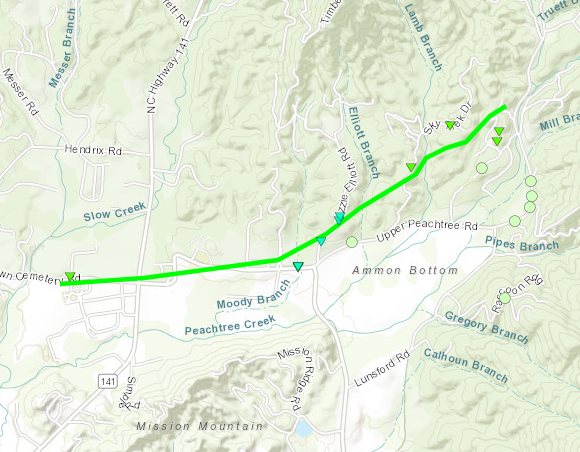 
|
||||||||||||||||
The Enhanced Fujita (EF) Scale classifies tornadoes into the following categories:
| EF0 Weak 65-85 mph |
EF1 Moderate 86-110 mph |
EF2 Significant 111-135 mph |
EF3 Severe 136-165 mph |
EF4 Extreme 166-200 mph |
EF5 Catastrophic 200+ mph |
 |
|||||
Wind & Hail Photos:
Wind
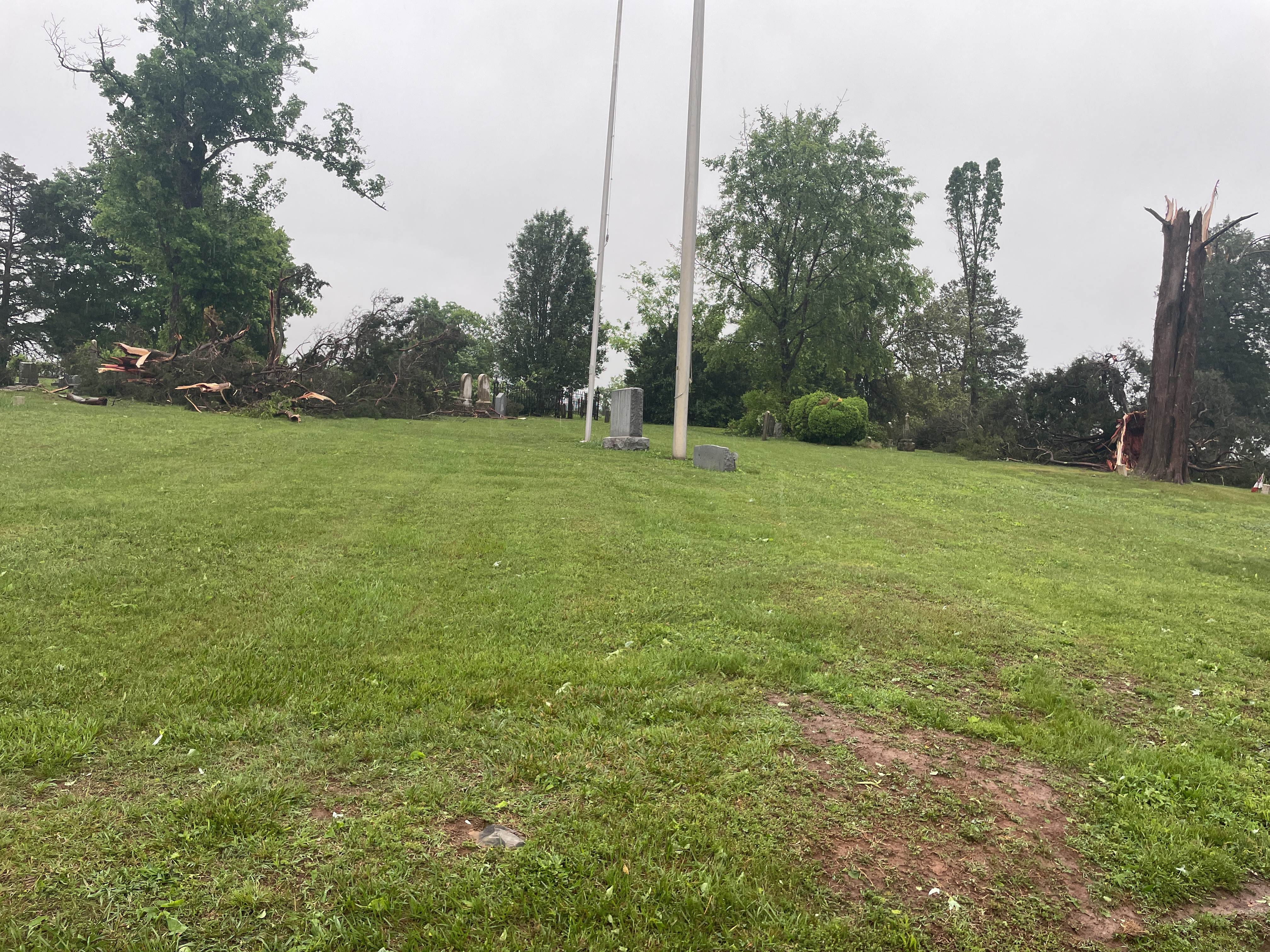
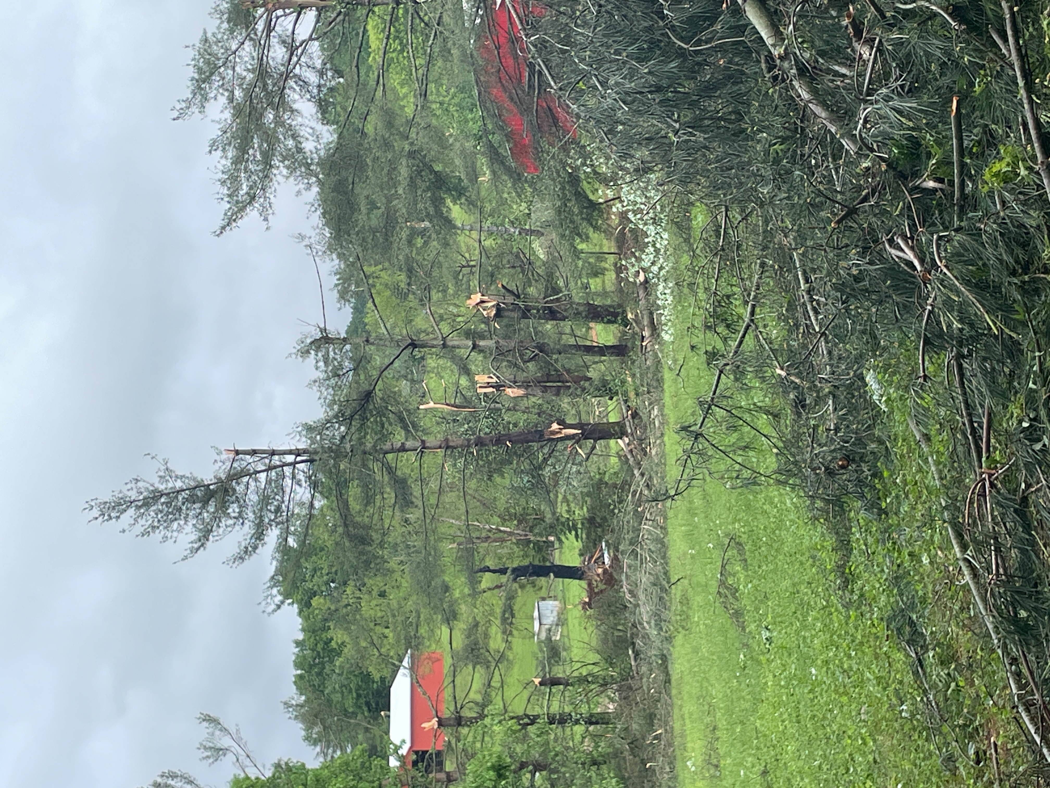
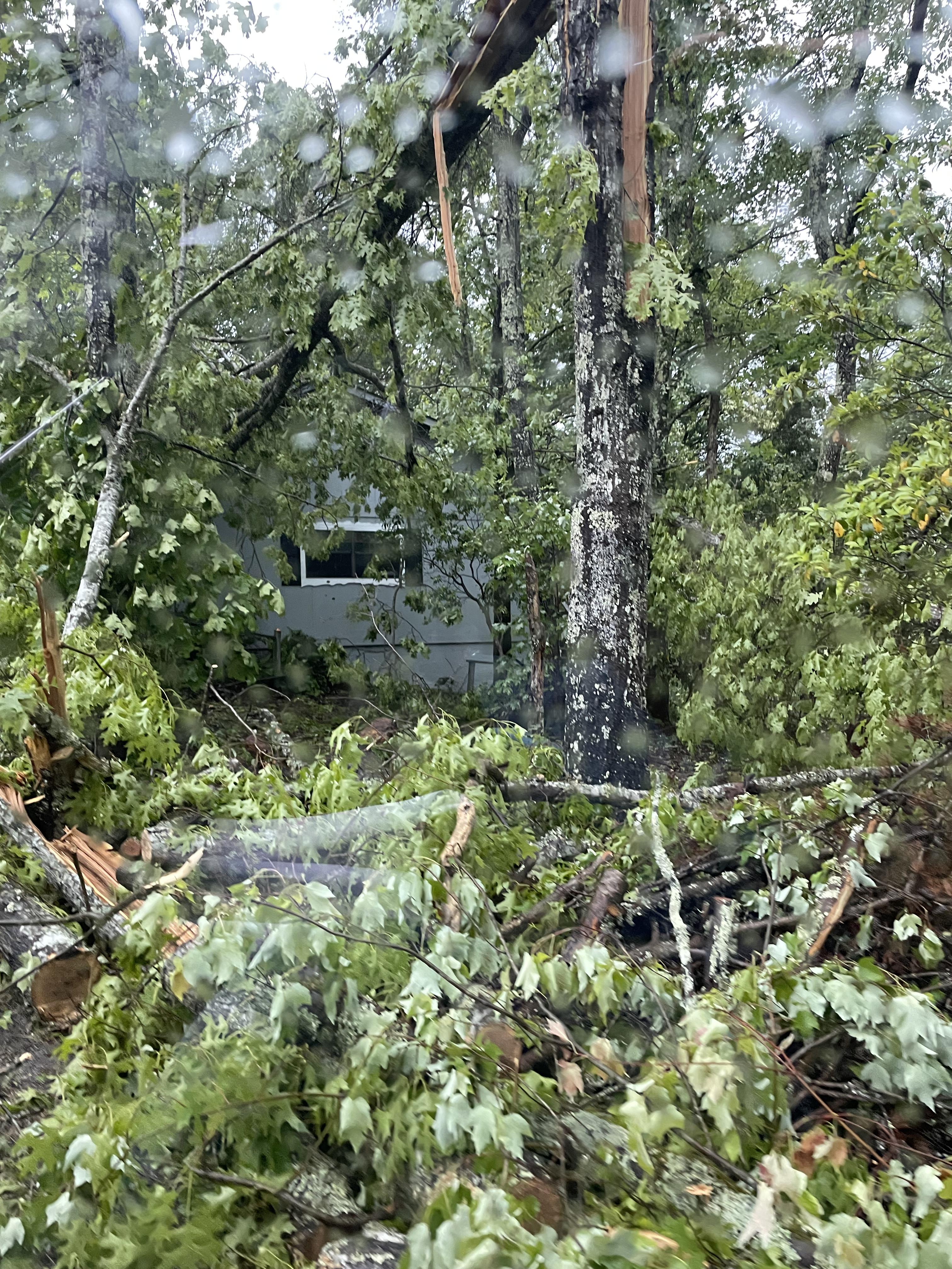
Significant damage occurred as a result of extreme straight line winds that were estimated to be in excess of 90 mph and to the same level as the EF-1 tornado that occurred in eastern Cherokee County, NC. Many other places saw less intense severe winds, but the photos below show the most significant winds from the event.
 |
 |
 |
| Straight line winds in association with a severe supercell thunderstorm rated at 88 mph snapped several trees within the Hamblen Memorial Gardens. | Several trees were snapped after winds up to 93 mph occurred during a severe supercell thunderstorm in eastern Hamblen County between Morristown and Russellville | Straight line winds up to 95 mph in association with a tornadic thunderstorm felled several large trees along the right flank of the tornado path in eastern Cherokee County, NC |
Hail
Several instances of large hail occurred across the area with the ones shown below near the size of a baseball. Hail to this size is very rare in our region.
 |
 |
| Large hail fell in Bean Station and west to Rutledge, with the largest hailstones approaching 2.5 inches in diameter! Photo used with permission: Anna B. Bean Station, TN. | Large hail fell in Bean Station and west to Rutledge, with the largest hailstones approaching 2.5 inches in diameter! Photo used with permission: Anna B. Bean Station, TN. |
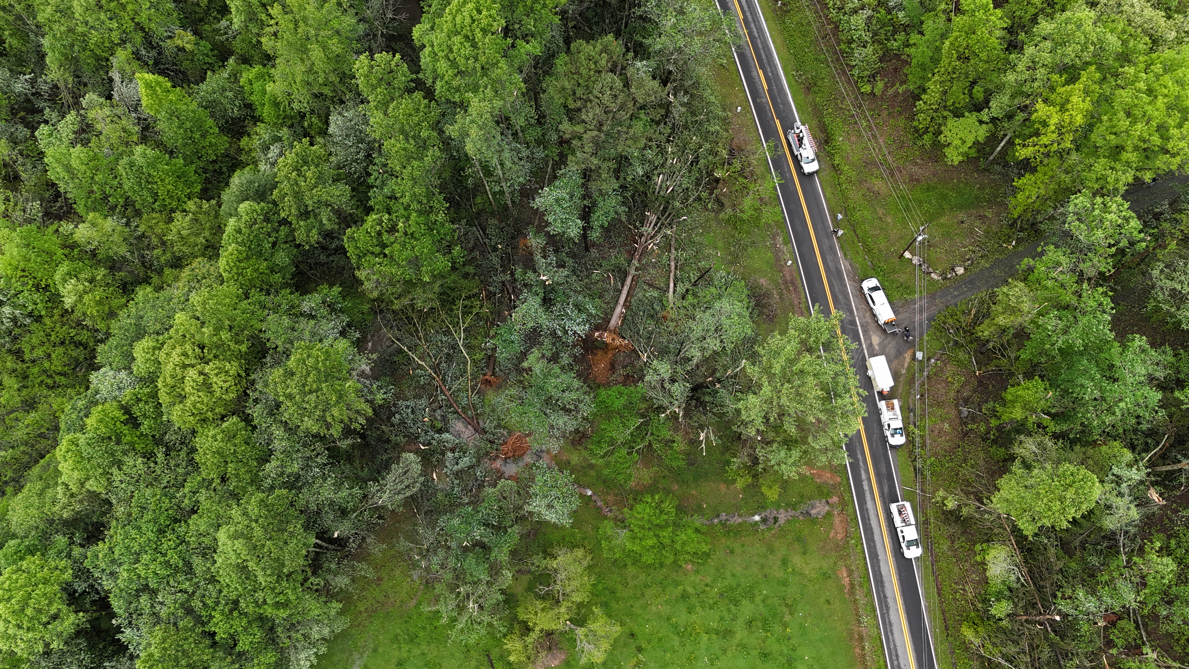
Tornado Damage Photos
 |
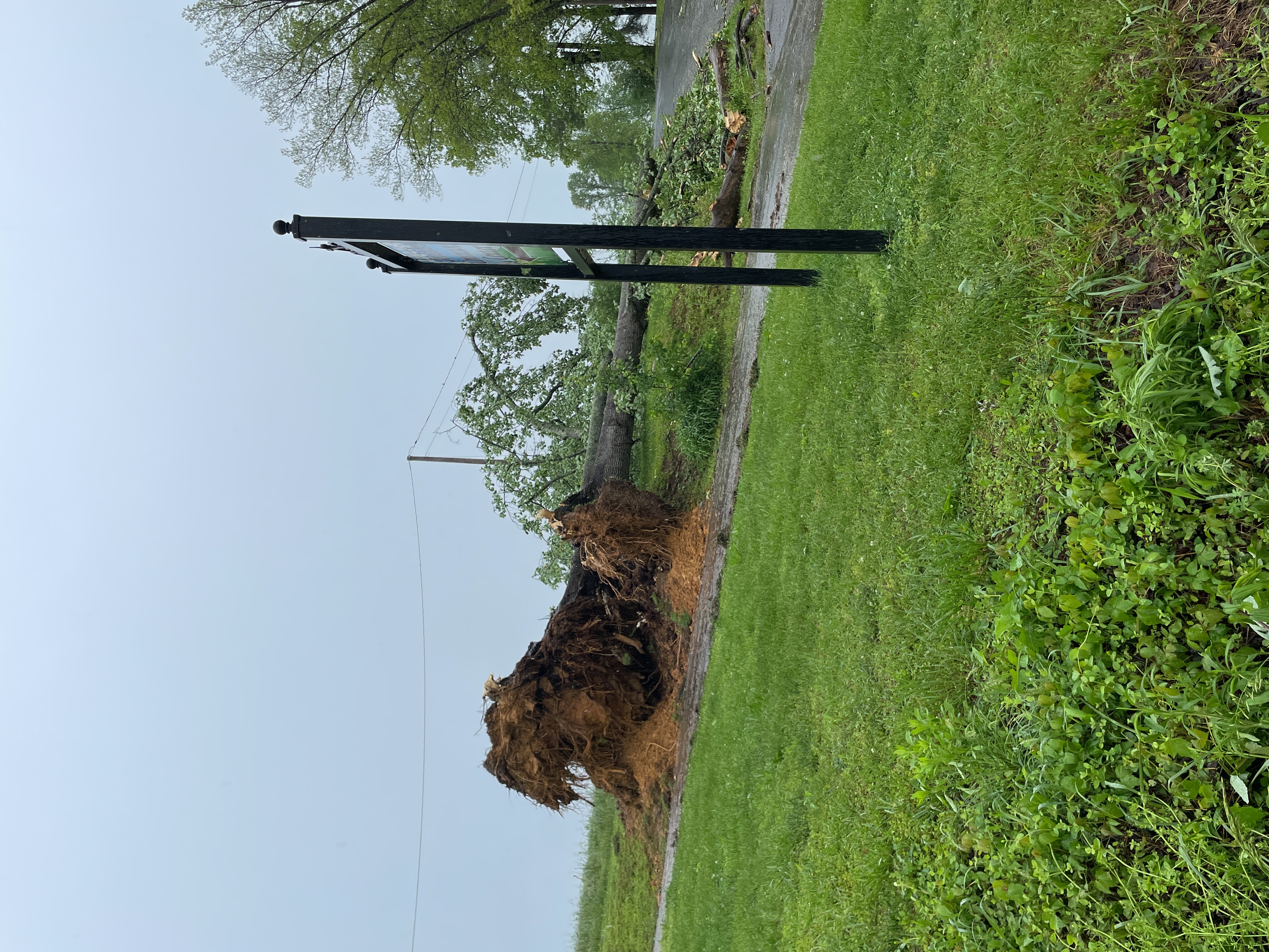 |
| An EF-1 Tornado felled a few large hardwood and softwood trees along a 2.5 mile long path with winds estimated up to 95 mph. | A very large tree uprooted along the same path |
Radar
*All images in this section are from May 8th
 |
| Animation of Base Reflectivity, Base Velocity, Storm Relative Velocity, and Correlation Coefficient |
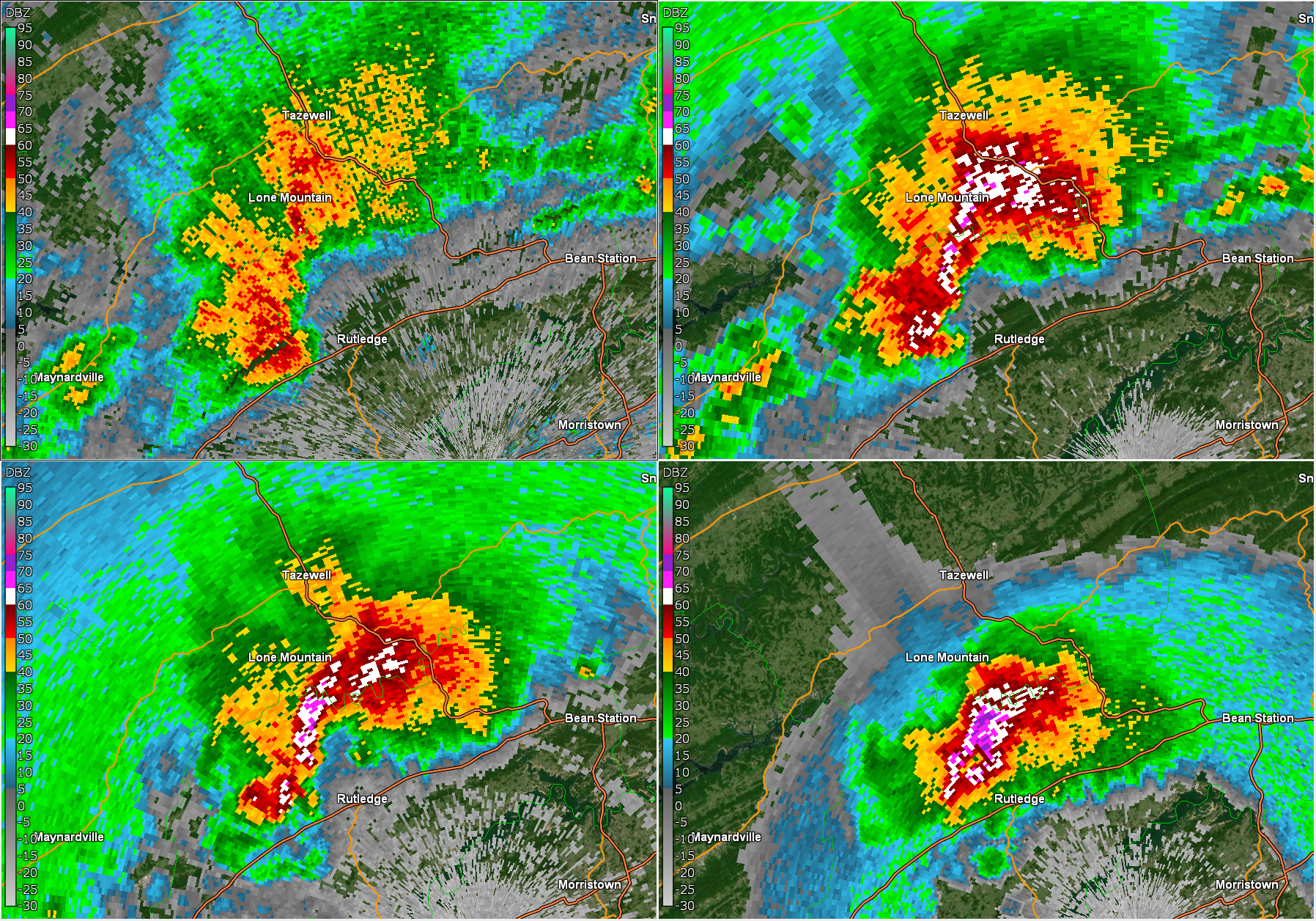
A supercell thunderstorm tracked from the northern Cumberland Plateau through Morristown and east to Greeneville during the morning hours of May 8. This animation shows the period when the storm was at its strongest, between Rutledge and Mosheim. It is rare to have such a strong and well-defined supercell storm move so close to the Morristown radar, and may interesting features were detected by our radar. The storm produced very large hail, damaging wind, and a funnel cloud, but a tornado did not reach the ground.
 |
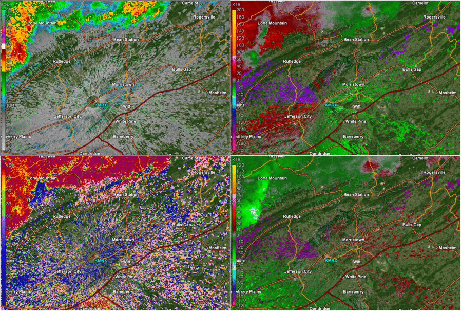
| 4-Panel of Base Reflectivity, Storm Relative Velocity, Base Velocity, and Correlation Coefficient at 10:12 AM EDT |
The lower right panel of this image shows base velocity, with the bright green colors indicating strong winds moving toward the radar (labeled KMRX in the lower right of all panels). The maximum wind speed detected by the radar is 70 mph near Washburn. A few minutes after this image, the Severe Thunderstorm Warning was updated to indicate that this was a destructive storm with 80 mph winds possible. There was some extensive wind damage reported near Rutledge and Bean Station as the storm continued east. Notice that there is a narrow line where radar data are missing, aligned from southwest to northeast between Washburn and Rutledge. This is where the radar beam is encountering the top of the Clinch Mountains.
 |
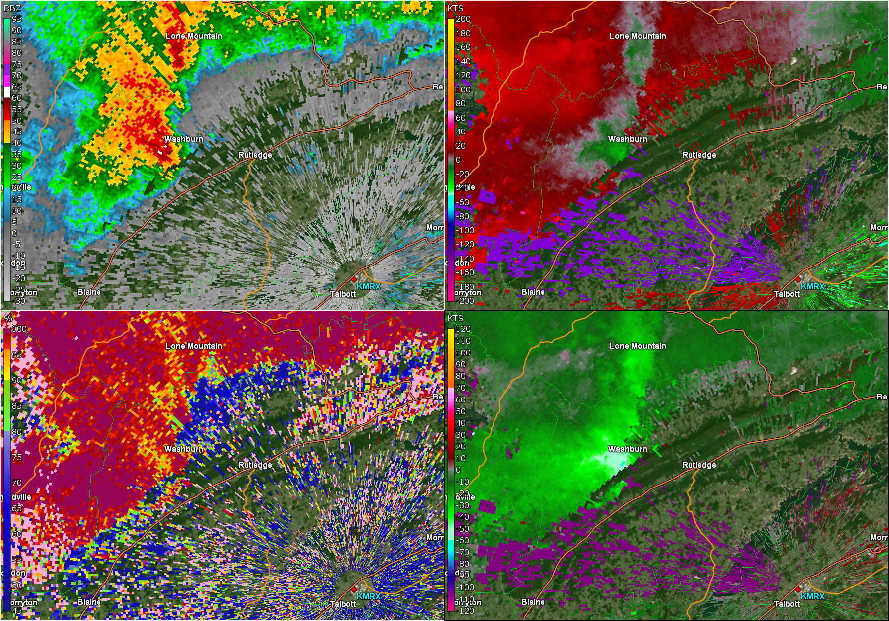
| Base Reflectivity Tilts at 10:15 AM EDT |
This image shows reflectivity at different levels of the storm. The upper left panel is the lowest slice, then the upper right shows a higher slice, followed by the lower left and the lower right. The highest slice in the lower right panel shows very high reflectivity (pink to violet colors). The radar sends out a beam of energy, which encounters objects in the atmosphere, and a portion of that energy gets reflected back to the radar. A large object reflects more energy than a small object, so the high reflectivity values here indicate very large hail in this storm. Another interesting feature in this image is the low reflectivity (gray colors) located behind the storm, west of Tazewell. This feature is called a Three Body Scatter Spike (TBSS). It appears when part of the radar’s energy beam reflects off hail toward the ground, reflects off the ground and back to the hail, and then reflects off the hail to the radar. The extra time that it takes this energy to travel (only a fraction of a millisecond) results in the radar plotting this returned energy behind the storm. A TBSS as large as this one indicates very large hail in the storm, and 2.5-inch diameter hail was observed in Rutledge about 5 minutes after the time of this image.
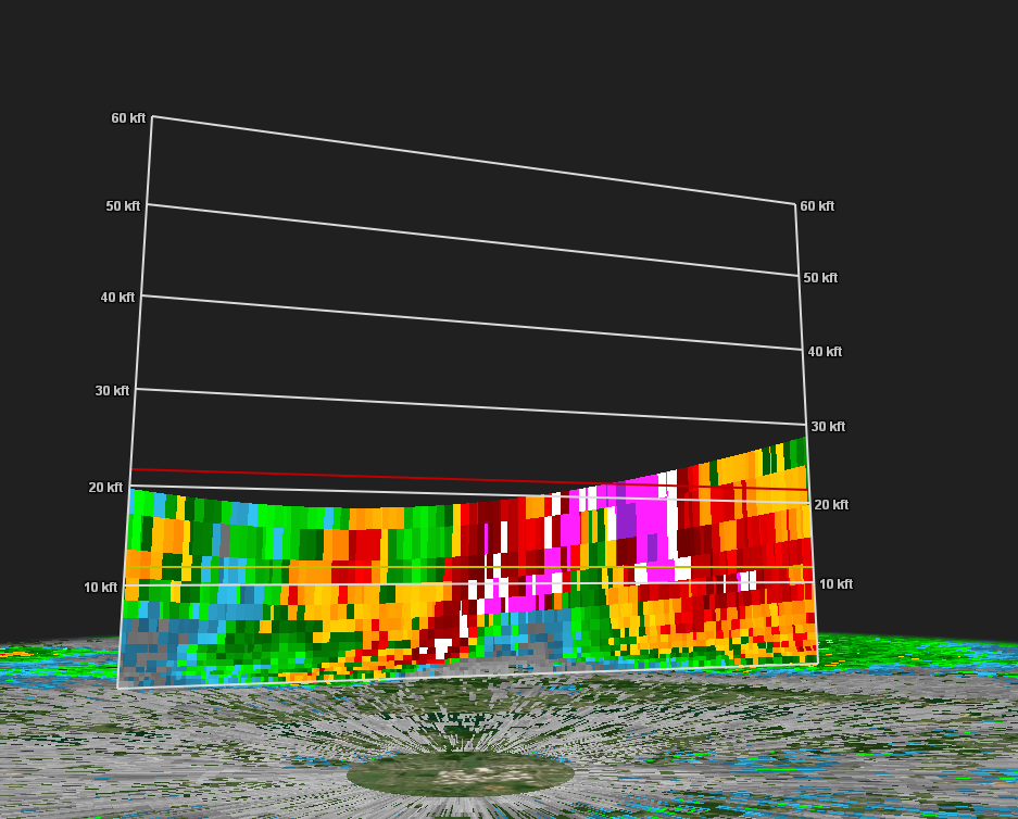 |
| Base Reflectivity Cross-Section at 10:18 AM EDT |
This image is a cross section through the storm when it was over Rutledge, looking from the radar toward the northwest. The vertical scale is thousands of feet, and since the storm is so close to the radar, we can only see the storm up to around 20,000 ft. The interesting feature to note is the column of weak reflectivity (green colors) from just below 10,000 ft to 20,000 ft, surrounded by very high reflectivity (pink, violet, and white colors) on either side. This feature is called a Bounded Weak Echo Region. It is caused by a very strong, rotating updraft. The updraft is a rising column of air that suspends precipitation high in the storm, and prevents it from falling in this area. The rising, rotating column of air pushes hail higher in the storm and outside of the updraft area. This is a key feature of supercell thunderstorms, because it allows the updraft to persist by separating the rising air from the descending air.
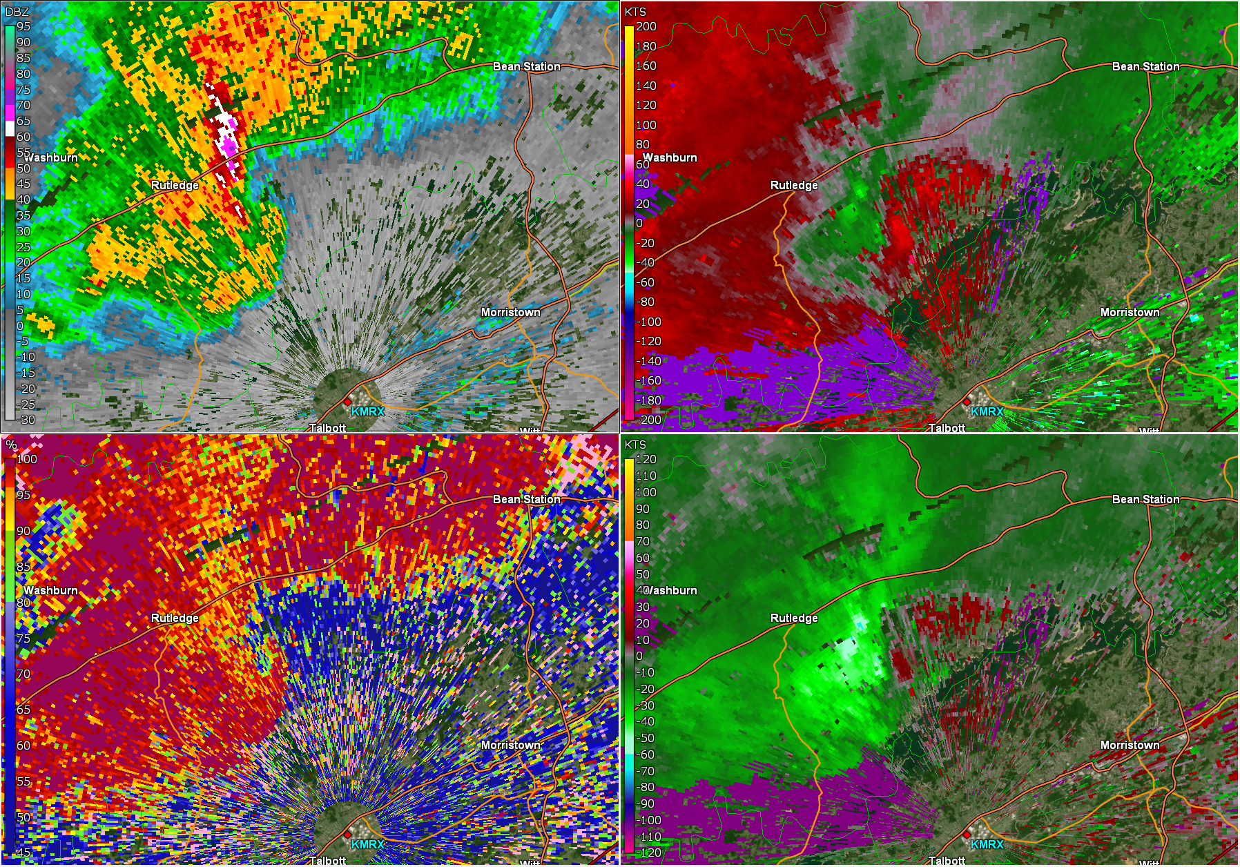 |
| 4-Panel of Base Reflectivity, Storm Relative Velocity, Base Velocity, and Correlation Coefficient at 10:25 AM EDT |
A Tornado Warning was issued around the time of this image for Grainger and Hamblen counties. As the storm crossed the Clinch Mountains, it developed a hook echo (seen in the reflectivity in the upper left panel) and counter-clockwise rotation (seen in the storm-relative velocity image in the upper right panel, southeast of Rutledge). Sometimes, as storms move past ridges and downslope, rotation can intensify due to winds strengthening as they move down the side of a mountain. That appears to be what occurred with this storm, and although there was some scattered wind damage southeast of Rutledge, there was no tornado on the ground. The damage was likely caused by straight-line winds from a downdraft, which can be seen by the strong winds moving toward the radar (bright green colors) in the lower right panel.
 |
| 4-Panel of Base Reflectivity, Storm Relative Velocity, Base Velocity, and Correlation Coefficient at 10:48 AM EDT |
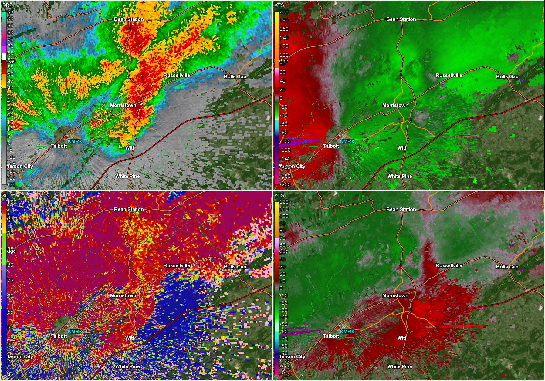
Around the time of this radar image, there were reports and videos of a rotating funnel cloud on the east side of Morristown. The reflectivity image in the upper left panel shows a well-defined hook echo where the funnel cloud was spotted, but the storm-relative velocity image in the upper right panel shows only very weak rotation. A storm damage survey confirmed that there was no tornado on the ground. The wind damage that occurred around Russellville Elementary School and the Morristown Memorial Gardens Mausoleum was determined to be caused by straight-line winds.
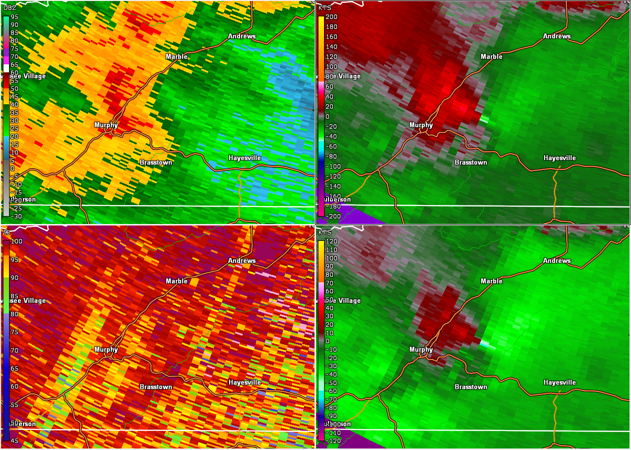 |
| 4-Panel of Base Reflectivity, Storm Relative Velocity, Base Velocity, and Correlation Coefficient at 11:39 PM EDT |
In contrast to the storm that crossed Grainger and Hamblen counties, this storm was far from the radar, in Cherokee County, NC. At that distance, due to the earth’s curvature, the lowest that the radar can detect is around 5,500 feet above the ground. The radar beam also gets wider as it gets farther from the radar, so resolution is reduced. In this image, the reflectivity shown in the upper left panel does not show a pretty hook echo, but it does exhibit a “L”shape. The storm-relative velocity in the upper right shows strong rotation (bright green next to red) east of Murphy, but this is occurring 5,500 ft above the ground. This rotation indicates a mesocyclone, or a rotating updraft within the storm, but it is not detecting the actual tornado near the ground. Sometimes, rotation aloft precedes a tornado on the ground, but not always. Because of this rotation signature, a Tornado Warning was issued near the time of this image, and a tornado touched down a few minutes later in the Peachtree community east of Murphy.
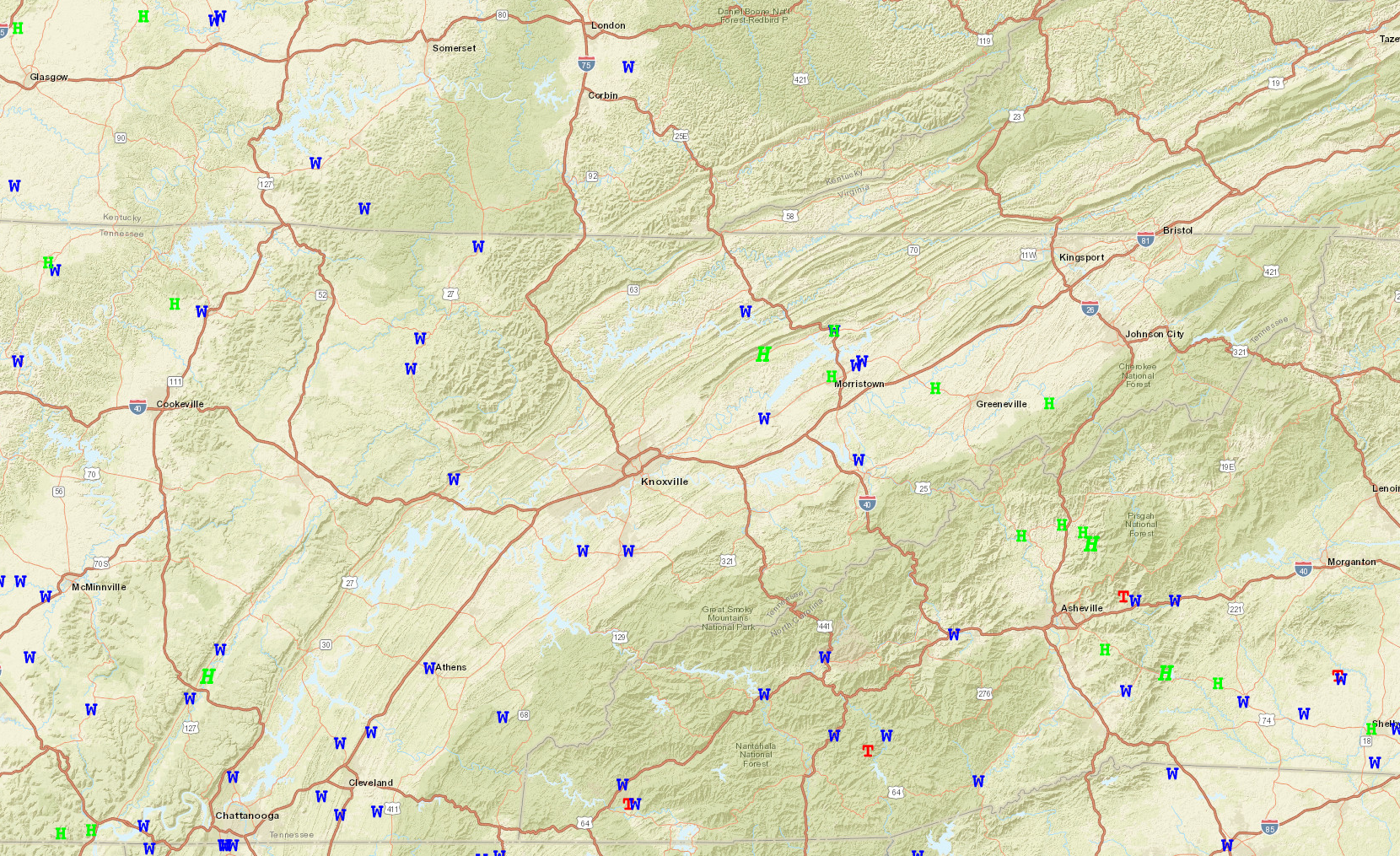
Storm Reports
W - Wind
H - Hail
T - Tornado
Public Information Statement
National Weather Service Morristown TN
432 PM EDT Wed May 8 2024 /332 PM CDT Wed May 8 2024/

...Hamblen County Tennessee Damage Survey Results from 5/8/2024...

The NWS Morristown office surveyed the damage that occurred late
this morning in Russellville, Tennessee. It was determined to be
caused by a downburst centered near East Andrew Johnson Highway,
Bethesda and Old Kentucky Road. The winds were estimated to be 80
to 90 mph. Radar estimates show this occurred just before 11 am EDT.

Significant roof damage occurred to the Russellville Elementary and
subsequent water intrusion into several classrooms and gymnasium.
Other structural roof damage occurred to some homes and several tree
trunks were snapped with just a few trees uprooted. The Morristown
Memorial Gardens Mausoleum also sustained roof damage. The Bethesda
Cemetery sustained numerous trees snapped. The total area affected
was roughly two square miles.
Public Information Statement
National Weather Service Morristown TN
1154 AM EDT Fri May 10 2024 /1054 AM CDT Fri May 10 2024/

...NWS Damage Survey for 05/08/24 Tornado Event - Update #2...

.Update...Additional information was analyzed and the path width
and length have been updated.

..Cherokee North Carolina Tornado near Peachtree...


Rating:                 EF1
Estimated Peak Wind:    95 mph
Path Length /statute/:  2.42 miles
Path Width /maximum/:   40 yards
Fatalities:             0
Injuries:               0

Start Date:             05/08/2024
Start Time:             11:41 PM EDT
Start Location:         4 E Murphy / Cherokee County / NC
Start Lat/Lon:          35.0918 / -83.9532

End Date:               05/08/2024
End Time:               11:42 PM EDT
End Location:           5 SSE Marble / Cherokee County / NC
End Lat/Lon:            35.1043 / -83.9149

Survey Summary:
Pockets of extensive tree damage were noted near and around the
Peachtree community. The tornado likely developed near Greenlawn
Cemetery Road and Memory Lane. It continued east across Upper
Peachtree Road causing some tree damage on Lizzie Elliot Road.
The tornado took a slight northeast jog and was non-continuous
throughout its life cycle. It crossed Sky Trek Drive and Shadow
Pond Road. The tornado lifted before crossing Upper Peachtree
Road again. Numerous trees were either uprooted or snapped along
the path. It was noted that large limbs were also downed. Other
significant tree damage was found where Upper Peachtree Road
turns north just past Trinity Drive close to Boyd Ridge Drive.
However, this damage was associated with straightline winds in
excess of 70 mph.

&&

EF Scale: The Enhanced Fujita Scale classifies tornadoes into the
following categories:

EF0.....65 to 85 mph
EF1.....86 to 110 mph
EF2.....111 to 135 mph
EF3.....136 to 165 mph
EF4.....166 to 200 mph
EF5.....>200 mph

NOTE:
The information in this statement is preliminary and subject to
change pending final review of the event and publication in
NWS Storm Data.


..TIME...   ...EVENT...      ...CITY LOCATION...     ...LAT.LON...
..DATE...   ....MAG....      ..COUNTY LOCATION..ST.. ...SOURCE....
            ..REMARKS..

0750 AM     Flash Flood      Oakdale                 35.99N 84.56W
05/09/2024                   Morgan             TN   911 Call Center

            Car partially submerged in the Oakdale City
            Park parking lot.

0745 AM     Flash Flood      2 SW Elgin              36.31N 84.63W
05/09/2024                   Scott              TN   911 Call Center

            Highway 27 in Glenmary is flooded; mudslide
            on River Road near Helenwood.

0650 AM     Flash Flood      Dunlap                  35.37N 85.39W
05/09/2024                   Sequatchie         TN   911 Call Center

            Numerous reports of flooding.

0615 AM     Tstm Wnd Dmg     2 NNE Flint Springs     35.06N 84.90W
05/09/2024                   Bradley            TN   Broadcast Media

            Several trees down across the southern
            portion of the county. Relayed to us by
            amateur radio operator from public radio.

0610 AM     Tstm Wnd Dmg     2 W Charleston          35.28N 84.80W
05/09/2024                   Bradley            TN   Dept of Highways

            Trees down.

0550 AM     Tstm Wnd Dmg     4 WSW Middle Valley     35.16N 85.25W
05/09/2024                   Hamilton           TN   Public

            Several large trees have been blown down
            with multiple power outages in the area.

0530 AM     Tstm Wnd Dmg     Dunlap                  35.37N 85.39W
05/09/2024                   Sequatchie         TN   911 Call Center

            Numerous reports of trees down across the
            county. Time estimated by radar.

1145 PM     Tstm Wnd Dmg     Marble                  35.18N 83.92W
05/08/2024                   Cherokee           NC   911 Call Center

            Reports of trees and powerlines down across
            the county. Also, an amateur radio operator
            reported a wind gust to 50 mph in the Marble
            area.
1141 PM     Tornado          4 E Murphy              35.09N 83.96W
05/08/2024                   Cherokee           NC   NWS Storm Survey

            A survey found EF-1 tornado damage, with
            peak winds of 95 mph. Path length was 2.42
            miles, path width was 40 yards. Pockets of
            extensive tree damage were noted near and
            around the Peachtree community. The tornado
            likely developed near Greenlawn Cemetery
            Road and Memory Lane. It continued east
            across Upper Peachtree Road causing some
            tree damage on Lizzie Elliot Road. The
            tornado took a slight northeast jog and was
            non-continuous throughout its life cycle. It
            crossed Sky Trek Drive and Shadow Pond Road.
            The tornado lifted before crossing Upper
            Peachtree Road again. Numerous trees were
            either uprooted or snapped along the path.
            It was noted that large limbs were also
            downed. Other significant tree damage was
            found where Upper Peachtree Road turns north
            just past Trinity Drive close to Boyd Ridge
            Drive. However, this damage was associated
            with straight line winds in excess of 70
            mph.
1125 PM     Tstm Wnd Dmg     3 SW Marble             35.14N 83.98W
05/08/2024                   Cherokee           NC   911 Call Center

            Trees down county-wide with time estimated
            from radar.

1105 PM     Tstm Wnd Dmg     2 WSW Jefferson City    36.11N 83.52W
05/08/2024                   Jefferson          TN   NWS Employee

            Couple of trees blown down on either side of
            New Market, TN. Time estimated by radar.

1055 PM     Tstm Wnd Dmg     4 NE Bullet Creek       35.32N 84.37W
05/08/2024                   Monroe             TN   911 Call Center

            One tree down.

1045 PM     Tstm Wnd Dmg     1 NE Maryville          35.76N 83.96W
05/08/2024                   Blount             TN   911 Call Center

            Trees and powerlines down across the county.
            Much of downtown Maryville is without power.
            Also, a tree caught on fire due to downed
            powerlines.

1030 PM     Tstm Wnd Dmg     Haletown (guild)        35.03N 85.54W
05/08/2024                   Marion             TN   Dept of Highways

            Trees down.

1030 PM     Tstm Wnd Dmg     1 E Friendsville        35.76N 84.11W
05/08/2024                   Blount             TN   911 Call Center

            Trees and powerlines down along Vinegar
            Valley Road.

1025 PM     Tstm Wnd Dmg     4 NW Oldfort            35.07N 84.78W
05/08/2024                   Bradley            TN   Dept of Highways

            Trees down.

1025 PM     Hail             South Pittsburg         35.02N 85.71W
05/08/2024  E1.50 Inch       Marion             TN   Public


1015 PM     Tstm Wnd Dmg     3 NE Palio              35.50N 85.29W
05/08/2024                   Bledsoe            TN   911 Call Center

            Trees down across the county with time
            estimated from radar.

1015 PM     Flash Flood      2 NE Palio              35.49N 85.29W
05/08/2024                   Bledsoe            TN   911 Call Center

            Flooding along U.S. 127 in multiple
            different locations in Bledsoe County.

1011 PM     Hail             3 SE South Pittsburg    34.99N 85.68W
05/08/2024  E1.00 Inch       Marion             TN   Public

            Report from mPING: Quarter (1.00 in.).

1010 PM     Tstm Wnd Dmg     1 E Mcdonald            35.11N 84.96W
05/08/2024                   Bradley            TN   Dept of Highways

            Trees down.

1010 PM     Tstm Wnd Dmg     Athens                  35.45N 84.61W
05/08/2024                   McMinn             TN   911 Call Center

            Trees down close to Athens. Location
            approximate. Time estimated by radar.

1010 PM     Rain             5 SE Decatur            35.48N 84.73W
05/08/2024  M4.30 Inch       McMinn             TN   Public

            Reported by Trained Spotter. Rainfall
            measured by WX station in Idlewild, TN area
            so far today.

1000 PM     Tstm Wnd Dmg     Kingston                35.87N 84.51W
05/08/2024                   Roane              TN   911 Call Center

            Trees and powerlines down county-wide.

0955 PM     Hail             Orme                    35.01N 85.81W
05/08/2024  M1.00 Inch       Marion             TN   Trained Spotter

            Emergency manager reported hail from a
            trained spotter.

0950 PM     Tstm Wnd Dmg     1 N Hopewell            35.25N 84.90W
05/08/2024                   Bradley            TN   Dept of Highways

            Trees down.

0950 PM     Tstm Wnd Dmg     2 NE Harriman           35.95N 84.53W
05/08/2024                   Roane              TN   911 Call Center

            Trees down on Highway 61. Time estimated by
            radar.

0943 PM     Hail             3 S Palio               35.43N 85.33W
05/08/2024  E3.00 Inch       Bledsoe            TN   Public

            Report from mPING: Tea Cup (3.00 in.).

0915 PM     Tstm Wnd Dmg     2 WSW Elgin             36.32N 84.64W
05/08/2024                   Scott              TN   911 Call Center

            Trees down on Nydeck Trail that have
            resulted in powerlines being knocked down.
            Location approximate and timing based on
            radar.

0240 PM     Flash Flood      Paint Rock              35.74N 84.52W
05/08/2024                   Roane              TN   Trained Spotter

            .

1210 PM     Tstm Wnd Dmg     3 NNW Newport           36.00N 83.21W
05/08/2024                   Cocke              TN   911 Call Center

            Few trees down.

1148 AM     Hail             2 ENE Liberty           36.15N 82.59W
05/08/2024  M1.25 Inch       Washington         TN   Public


1115 AM     Hail             Mosheim                 36.19N 82.96W
05/08/2024  M1.50 Inch       Greene             TN   Emergency Mngr


1055 AM     Tstm Wnd Dmg     Russellville            36.26N 83.20W
05/08/2024                   Hamblen            TN   Amateur Radio

            Roof, window, and other structural damage to
            Russellville Intermediate School.

1045 AM     Tstm Wnd Dmg     Russellville            36.26N 83.20W
05/08/2024                   Hamblen            TN   NWS Employee

            Large Trees Down.

1045 AM     Tstm Wnd Dmg     2 NE Morristown         36.24N 83.27W
05/08/2024                   Hamblen            TN   911 Call Center

            Tree on house on Old Liberty Hill Rd.

1045 AM     Tstm Wnd Dmg     2 NE Morristown         36.24N 83.27W
05/08/2024                   Hamblen            TN   Amateur Radio

            Tree down on home on Quillen Drive.

1044 AM     Hail             Morristown              36.22N 83.30W
05/08/2024  M1.00 Inch       Hamblen            TN   NWS Employee


1035 AM     Hail             Bean Station            36.34N 83.29W
05/08/2024  E1.50 Inch       Grainger           TN   Public


1025 AM     Tstm Wnd Dmg     Bean Station            36.34N 83.29W
05/08/2024                   Grainger           TN   911 Call Center

            Trees and power lines down countywide.

1020 AM     Hail             Rutledge                36.28N 83.52W
05/08/2024  E2.50 Inch       Grainger           TN   Broadcast Media


0955 AM     Tstm Wnd Dmg     1 WSW Russellville      36.25N 83.22W
05/08/2024                   Hamblen            TN   Emergency Mngr

            Roof damage to the mausoleum at Hamblen
            Memory Gardens.

0955 AM     Tstm Wnd Dmg     1 ENE Lone Mountain     36.39N 83.58W
05/08/2024                   Claiborne          TN   Emergency Mngr

            *** 1 FATAL ***
            Trees down. Home destroyed. Tree fell on car
            killing the occupant at the intersection of
            Lone Mountain Rd, and Jennings Lane.

0950 AM     Tstm Wnd Dmg     Sunbright               36.24N 84.67W
05/08/2024                   Morgan             TN   911 Call Center

            Trees down.

0855 AM     Tstm Wnd Dmg     Winfield                36.56N 84.45W
05/08/2024                   Scott              TN   Dept of Highways

            Trees down.
Environment
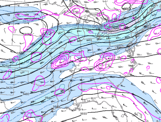
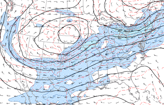
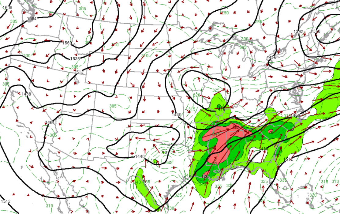
An upper level jet across from the southern Plains to the Ohio and Tennessee valleys was dominated by strong west to southwest flow aloft with a series of jet streaks (short-waves) moving quickly across the region. These waves produced a series of thunderstorm complexes that moved across the Tennessee valley from the morning of May 8th until the morning of May 9th.
Each upper level jet streak produced large-scale forcing over the Tennessee valley into the southern Appalachians with the 300mb analysis showed divergence aloft which aided in the development of storms.
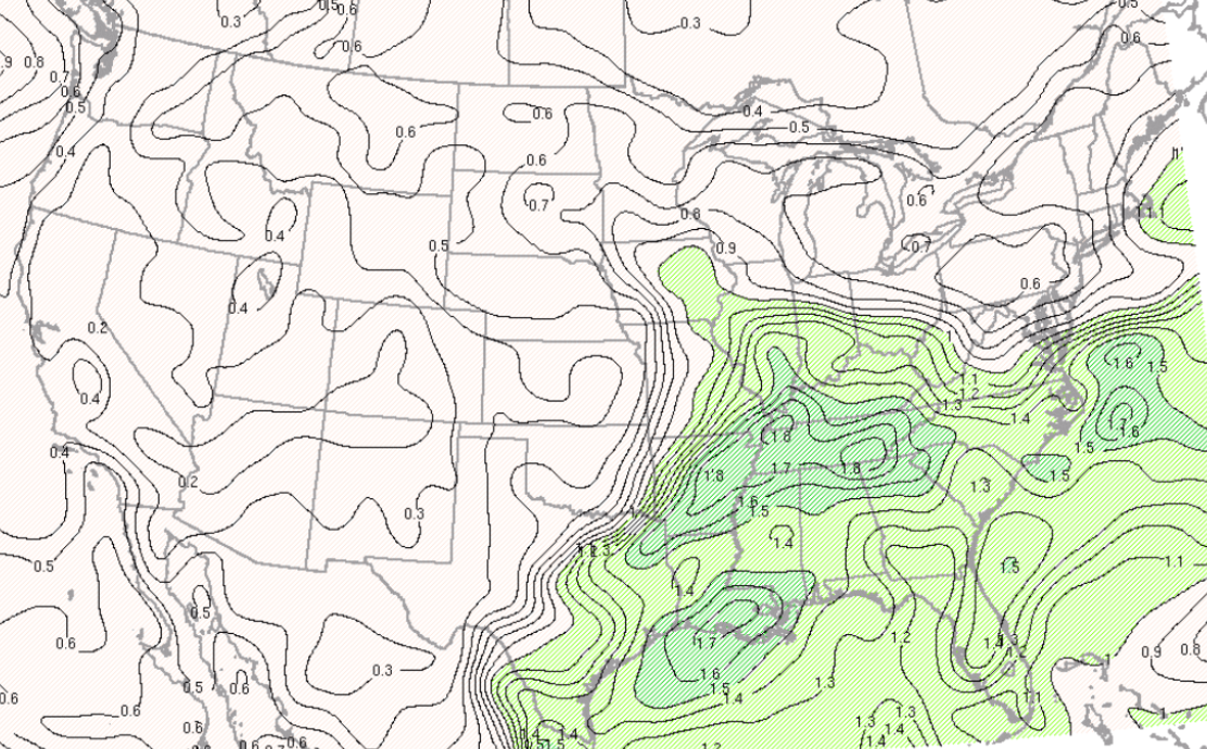
The upper forcing enhanced the boundary layer jet over the Mississippi and Tennessee valleys with southwest winds increasing to 30-40 kts. This low level jet pulled abundant moisture and instability northward into the region.
 |
 |
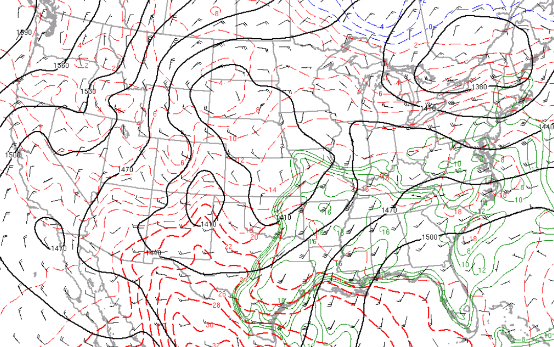 |
Figure 1: 300mb Heights, Divergence, and Winds at 1800 UTC, 08 May 2024 |
Figure 2: 500mb Heights, Temperature, and Winds at 1800 UTC, 08 May 2024 | Figure 3: 850mb Heights, Temperature, and Winds at 1800 UTC, 08 May 2024 |
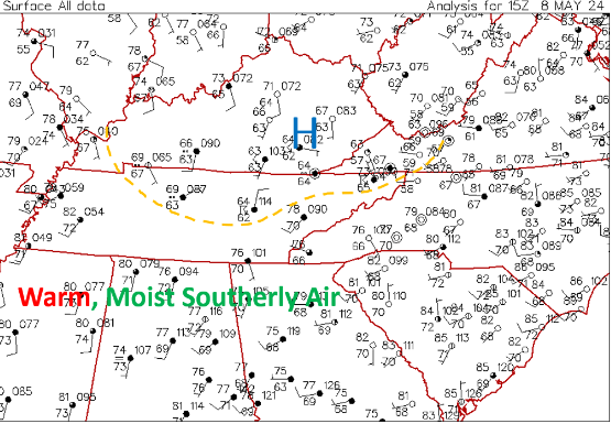
The surface analysis from 1500 UTC, 08 May 2024 to 0800 UTC, 09 May 2024 depicted an outflow boundary from a series of storm complexes. Initially this boundary was located in close proximity from the northern Plateau to near Morristown Tennessee. Warm and moist air mass ahead of this boundary produced a series of severe storms the morning of May 8th 2024 that produced very large hail and damaging winds. A funnel cloud was observed near Morristown Tennessee.
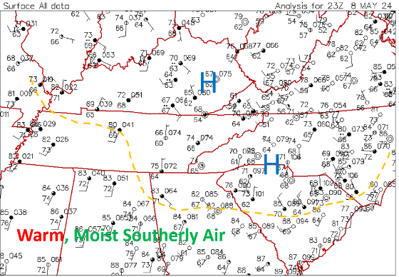
This boundary continued to move slowly south during the day and became nearly stationary across middle Tennessee to extreme southeast Tennessee and southwest North Carolina into the night. Warm and moist conditions continued to pull northward into this boundary producing rounds of thunderstorm complexes.
 |
 |
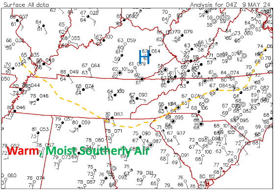 |
| Figure 4: Surface Station Plot at 1500 UTC, 08 May 2024 | Figure 5: Surface Station Plot at 2300 UTC, 08 May 2024 | Figure 6: Surface Station Plot at 0400 UTC, 09 May 2024 |
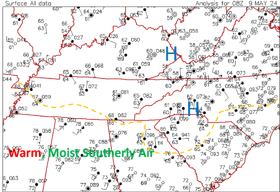 |
| Figure 7: Surface Station Plot at 0800 UTC, 09 May 2024 |
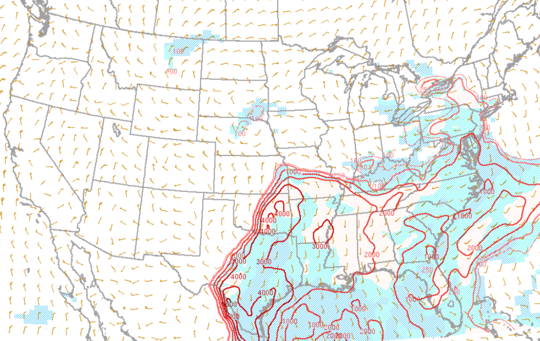
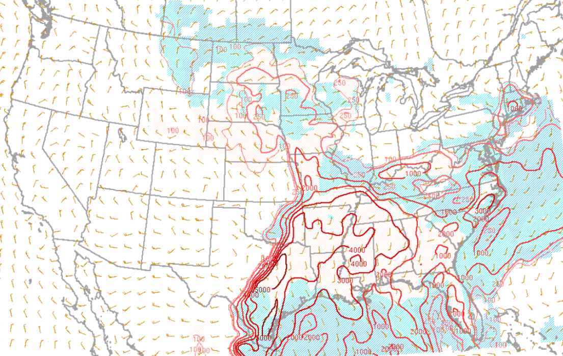
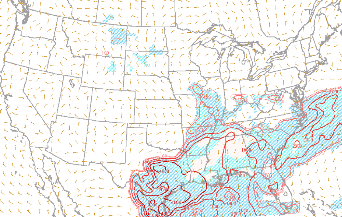
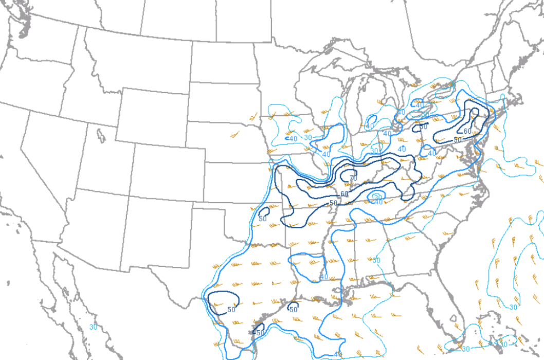
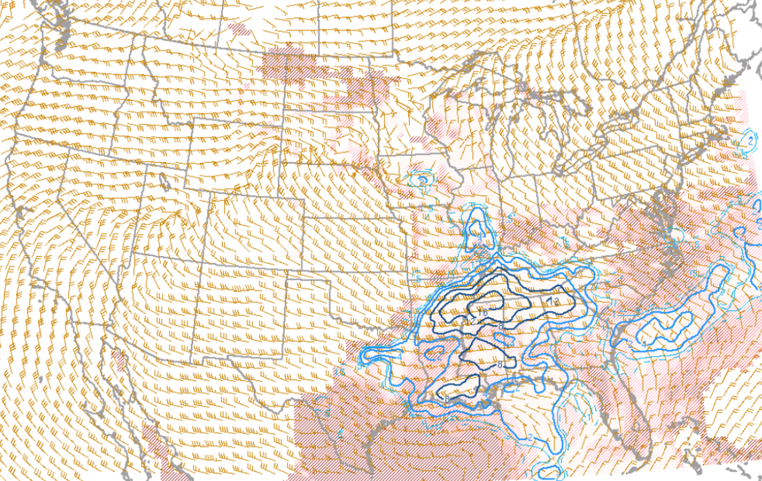
The SPC mesoanalysis depicted an unstable environment with MLCAPES of 1000-2000 J/Kg. As noted above the 0-3 km MLCAPE was quite high with values of 100-150.
Hail CAPES of 700-900 J/Kg and effective storm scale shear in the 50s produced an environment favorable for large hail growth and resident time for severe hail. These environmental factors during the morning of May 8th 2024 produced hail in excess of baseball size across Grainger and Hamblen counties in Tennessee.
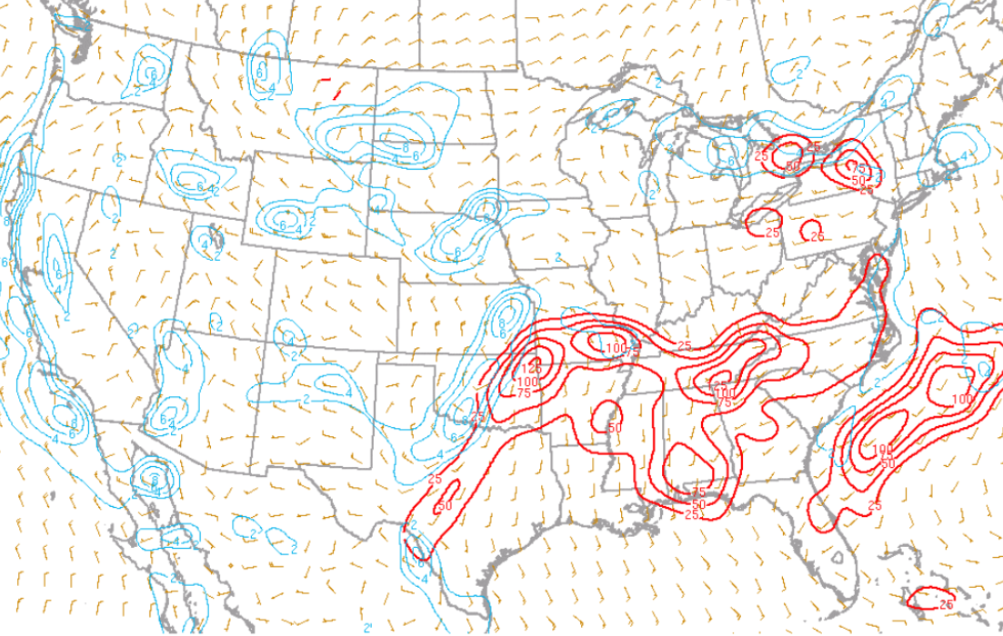
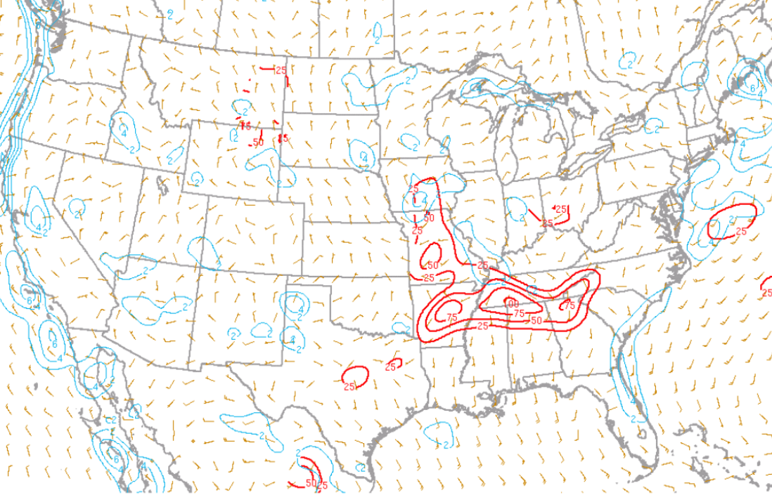
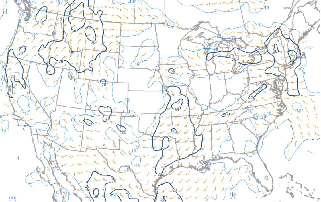
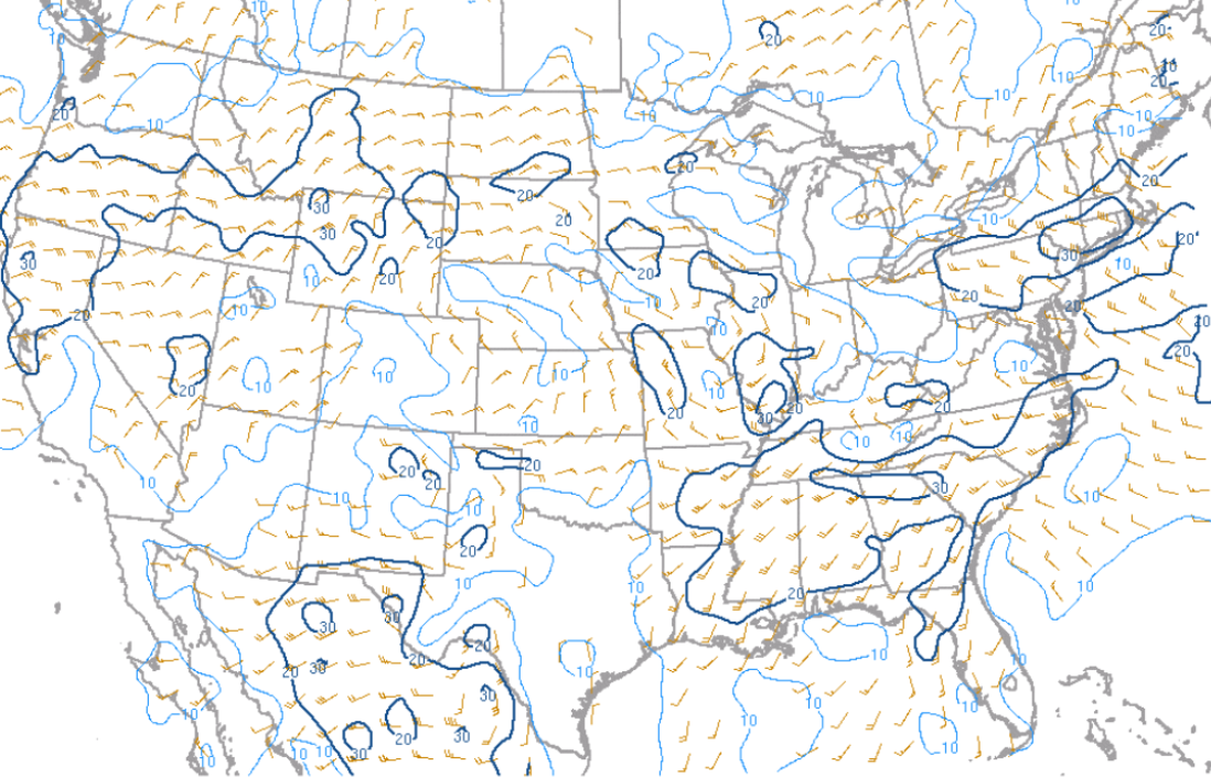
The Supercell Composite Parameter (SCP) and Significant Tornado Parameter depicted an overall favorable environment for rotating storms across northern Tennessee in the morning of May 8th and southeast Tennessee and southwest North Carolina early morning hours of May 9th. The main question was the location of the southward moving boundary across the region. These boundaries are often the focus for tornadogenesis.
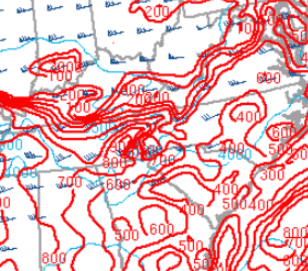
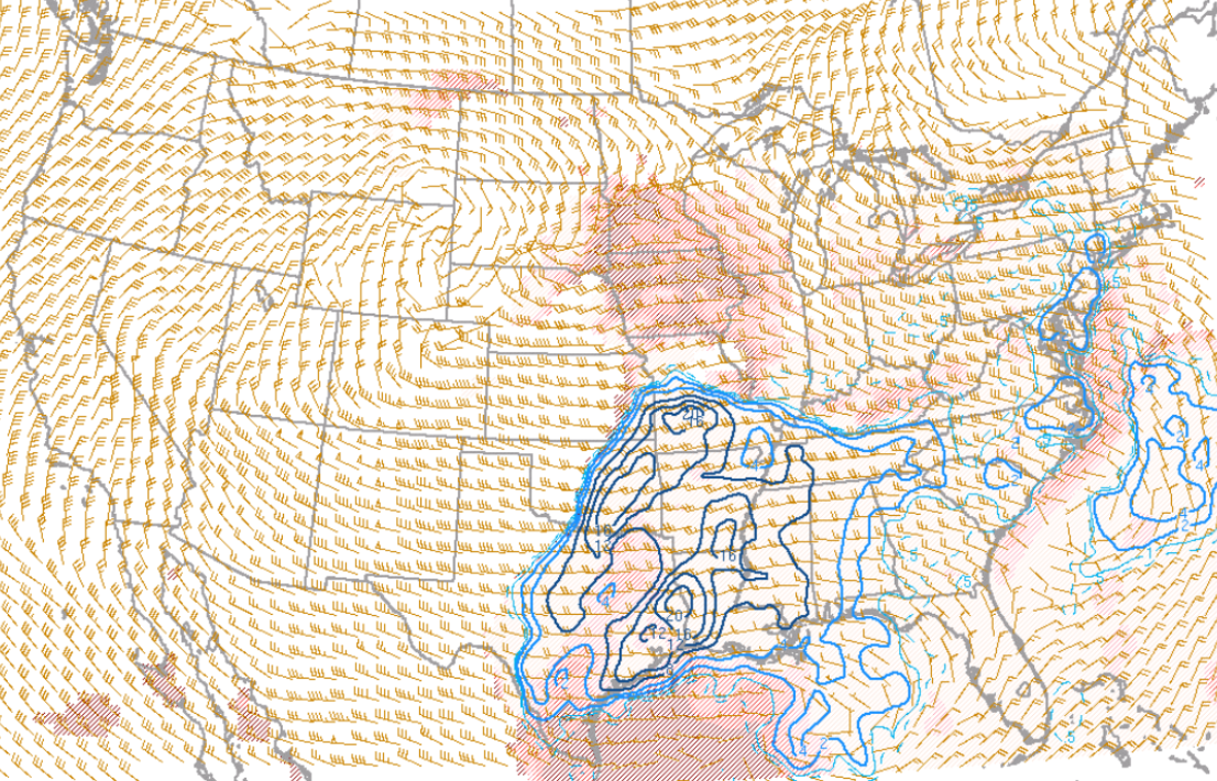
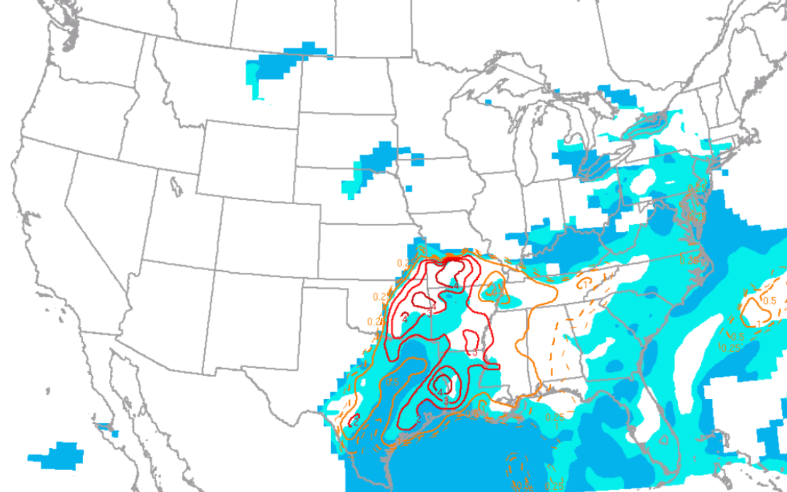
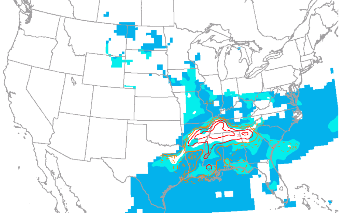
Besides the severe storm potential, there were several factors that contributed to the potential of heavy rainfall and flash flooding. The Precipitable Water values increased to 1.8 inches or more across parts of the area which is near the maximum ever recorded across the area for early May. The unseasonably high moisture content of the air mass combined with strong moisture transport into the Tennessee valley set the stage for heavy rainfall. The thunderstorms with torrential rains trained along this nearly stationary boundary produced flash flooding.
 |
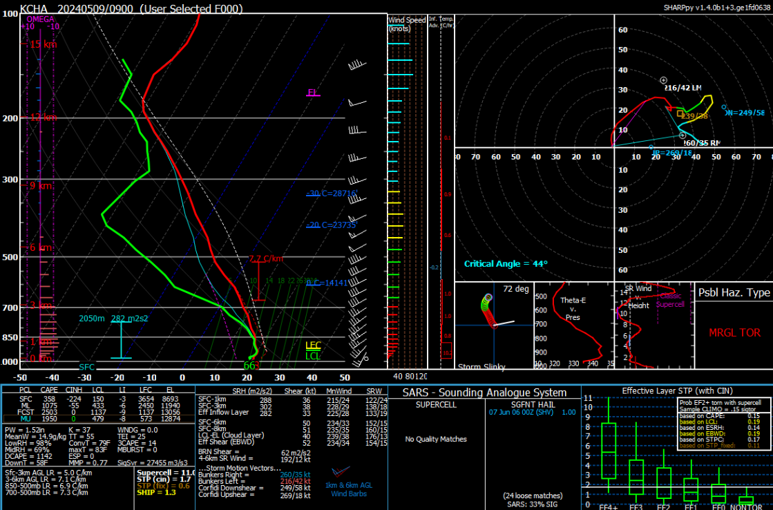 |
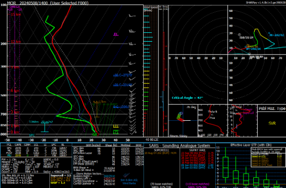
 |
| Figure 8: RAP Initialization Sounding at KMOR (Morristown, TN) at 1400 UTC, 08 May 2024 | Figure 9: RAP Initialization Sounding at KCHA (Chattanooga, TN) at 0900 UTC, 09 May 2024 | Figure 10: MLCAPE and CIN at 1500 UTC, 08 May 2024 |
 |
 |
 |
| Figure 11: MLCAPE and CIN at 2300 UTC, 08 May 2024 | Figure 12: MLCAPE and CIN at 0800 UTC, 09 May 2024 | Figure 13: 0-3 km MLCAPE and Surface Vorticity at 1500 UTC, 08 May 2024 |
 |
 |
 |
| Figure 14: 0-3 km MLCAPE and Surface Vorticity at 0500 UTC, 09 May 2024 | Figure 15: CAPE (-10 to -30 C), Freezing Level, and 0-6 km Shear at 1500 UTC, 08 May 2024 | Figure 16: Effective Shear at 1500 UTC, 08 May 2024 |
|
 |
 |
| Figure 17: Effective Shear at 0400 UTC, 09 May 2024 | Figure 18: 0-1 km Shear at 1500 UTC, 08 May 2024 | Figure 19: 0-1 km Shear at 0600 UTC, 09 May 2024 |
 |
 |
 |
| Figure 20: Supercell Composite Parameter (SCP) (effective layer with muCIN) and Bunkers Storm Motion at 1500 UTC, 08 May 2024 | Figure 21: Supercell Composite Parameter (SCP) (effective layer with muCIN) and Bunkers Storm Motion at 0500 UTC, 09 May 2024 | Figure 22: Significant Tornado Parameter (effective layer) and MLCIN at 1500 UTC, 08 May 2024 |
 |
 |
 |
| Figure 23: Significant Tornado Parameter (effective layer) and MLCIN at 0500 UTC, 09 May 2024 | Figure 24: Precipitable Water (inches) at 0500 UTC, 09 May 2024 | Figure 25: 850mb Moisture Transport (fill and vector), height (black), and theta-e (dashed green) at 0800 UTC, 09 May 2024 |
 |
Media use of NWS Web News Stories is encouraged! Please acknowledge the NWS as the source of any news information accessed from this site. |
|


 Local Radar
 Huntsville Radar
 Regional Satellite
 Graphical Forecast
 Weather Map