
Unseasonably warm temperatures continue through the weekend across the Southwest and southern U.S., with more than 100 record or near record maximum temperatures forecast through the rest of the week and over the weekend. Elevated to critical fire weather conditions will persist across the Plains and Southeast U.S. this weekend. Read More >
 |
||||||||
 |
||||||||
| An ominous looking sky signals the onset of severe, damaging winds and large hail in Knoxville, TN as the squall line moves into toward the Fort Sanders Medical Center. Photo credit: Jeff Weaver. | ||||||||
 |
||||||||
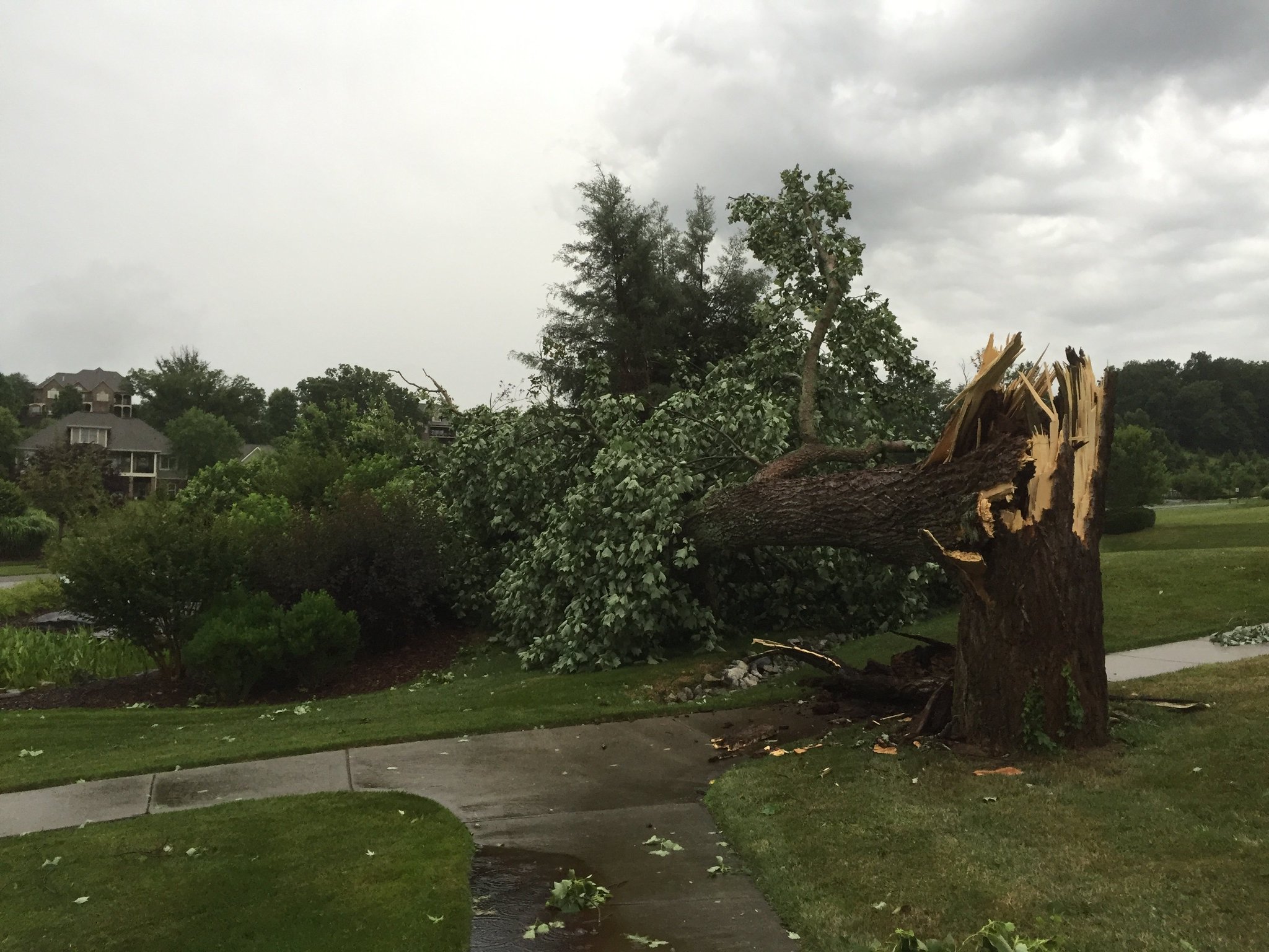
| A very large, mature tree completely blown over in the Highland Ridge subdivision of Johnson City, TN. Winds that knocked down these this large tree were likely in excess of 70 mph! Photo credit: Merritt McKinney. | ||||||||
 |
||||||||
| Convective outlook issued by the Storm Prediction Center on the afternoon of July 8, 2016. The orange area, donoted, the "enhanced" risk area for widespread damaging winds. This correleated well to most of the more extreme wind damage which generally occurred along and north of the Interstate 40 corridor. | ||||||||
| What is a derecho (Pronounced day-RAY-cho)? According to the National Weather Service's official definition, a derecho is a widespread and usually fast-moving windstorm associated with convection. Derechos include any family of downburst clusters produced by a MCS (Mesoscale Convective Complex -- also known as a large squall line), and can produce damaging straight-line winds over areas hundreds of miles long and more than 100 miles across. | ||||||||
 |
||||||||
| Image from the Morristown (KRMX) radar taken at 6:07 PM EDT on July 8, 2016. Despite a break in the center, note the length of this complex storms, extending from near Wytheville in the Central Appalachians of Virginia through the Tri-Cities and Knoxville metros and back along the Interstate 40 corridor into Middle Tennessee near Cookeville. This entire complex of storms was capable of producing 60-70 mph straight-line wind gusts, localized intense 80+ mph downbursts, large hail, and a tremendous amount of lightning. This long-lived complex of storms produced widespread damage throughout our area and into the Carolinas! The Image is courtesy of GR-2 Analyst Level Viewer. | ||||||||
| A long-level, intense complex of severe thunderstorms impacted the region on the afternoon and evening hours of Friday, July 8, 2016, bringing widespread, significant straight-line damaging wind damage to a majority of the counties across the National Weather Service in Morristown's County Warning Area (CWA). A moist, very unstable environment developed across the eastern Tennessee Valley and Southern Appalachian region by the early afternoon. In addition, a weak frontal boundary was draped just north of the region across southern Kentucky back into northern Middle Tennessee. This frontal boundary would serve as a focus, or trigger for the thunderstorms later that afternoon. Aloft, strong 40-50 kts of west to northwest wind shear set the stage for an organized complex of thunderstorms with intense updrafts. This wind shear help to sustain (and even strengthen) this complex of storms as it moved into East Tennessee. Additionally, the presence of some drier air aloft also played a role in the strength of the downdrafts within these thunderstorms as they descended to the ground. Overall, this derecho event likely produced the most widespread, intense straight-line wind damage observed across the region in nearly four years (July 5, 2012). It was also another important (and sobering) reminder that damaging straight-line winds can be just as deadly and produce just as much damage as weak EF-0 to EF-1 tornadoes. | ||||||||
 |
||||||||
| Sounding data obtained from Nashville, TN during the evening of July 8, 2016. This data indicated a fairly unstable atmosphere, moderately strong wind shear, and some drier air aloft. These ingredients helped to create a favorable environment for the intensity and sustainment of this derecho, specifically with respect to the wet microbursts (downbursts) that were observed. Image courtesy of the University of Wyoming. | ||||||||
 |
||||||||
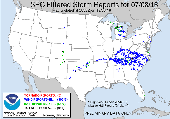
| Map of all the storm reports from July 8, 2016 across the nation. Note the high density of wind damage and hail reports across our area in the eastern Tennessee Valley and Southern Appalachians! | ||||||||
| Clusters of severe thunderstorms began to develop across Central Kentucky along a weak frontal boundary during the late morning and track southeast ward toward the Kentucky/Tennessee border over the course of the early to mid-afternoon. As this activity travelled south and east, it encountered a much more unstable environment. The stronger wind shear values in place helped these storms to an organized into a broad squall line as it crossed the state border into east Tennessee and southwest Virginia around 4:30 PM EDT. The thunderstorms intensified further as they began to accelerate further to the southeast, and widespread, significant wind damage was reported across numerous counties from Claiborne County, TN through Sullivan, Washington, Hancock, Greene, and Carter Counties. This damage included structural damage to homes and businesses in each county, as well as widespread tree damage from a series of wet downbursts that occurred (in addition to these straight-line winds). The most widespread and intense damage across northeast Tennessee occurred in Carter County. In addition to the numerous trees that were knocked down across the county, an intense downburst, with winds of 80+ mph completely destroyed structures a marina and a nearby camping area in Watauga Lake and the surrounding Cherokee National Forest. Additionally, several homes across the county sustained partial or significant roof damage. Tragically, there were two fatalities that occurred from trees that fell on them in a wooded area near the lake. Additional information on this part of the event can be found below. | ||||||||
 |
||||||||
| 6:26 PM EDT doppler radar image of the downburst that occurred over Watauga Lake in Carter County, TN. Note the bow shape in the radar reflectively indicating the presence of intense, straight-line winds. | ||||||||
 |
||||||||
| Significant tree damage observed near the shores of Watauga Lake in Carter County, TN from a downburst. Note the large spatial area of tree damage and the uniform direction that they were knocked down (rather than a narrow, twisting path). These are classic damage indicators of a downburst. Eastimated winds at this location were estimated to be in excess of 80 mph. | ||||||||
| Here is a link to an incredible video capuring this downburst event over Watauga Lake. The persons involved were very fortunate to have escaped in without major injury. Click here to watch this video! The video is courtesy of WJHL-TV in Bristol/Johnson City, TN. | ||||||||
 |
||||||||
| In addition to trees being snapped or knocked over in the forest, numerous structures across Carter, Hawkins, Washington, and Sullivan Counties were damaged or destroyed from falling trees or the strength of the winds that blew off roofs to these building. The image on the left shows large trees down on the Fish Springs Marina in Carter County, TN. The image on the right shows significant damage to a house from a large tree near the Fall Branch community in Washington County. Images are courtesy of WCYB and WJHL. | ||||||||
| Around 6:00 PM EDT, the large complex of storms split into two intense squall lines (see the radar image at the top of the page). The eastern portion of the line impacted far northeast Tennessee and southwest Virginia (discussed in the section above). The western portion of the line impacted Middle Tennessee, northern and central portions of the Cumberland Plateau, and much of the central and southern Valley through the late evening hours of 9:00 PM to 10:00 PM EDT. Widespread damaging winds to trees and structures were reported from Scott and Morgan County between 4:00 to 6:00 PM EDT and into Roane, Knox, Blount, and Sevier Counties later that evening between 6:00 to 8:00 PM EDT. Tragically, a fatality occurred in Knox County from a tree falling on person in their backyard during this time. This activity then tracked into Loudon, Monroe, and McMinn Counties after sunset, causing scattered tree damage and a few isolated cases of structural damage before exiting into western North Carolina between 9:00 to 10:00 PM EDT. The most significant, intense damage occurred from a very strong downburst over the Seymour community in far eastern Knox and western Sevier County. Within a two to three square mile area, numerous trees were knocked down and several buildings were damaged (or in the case of a few weaker structures, mostly destroyed). Winds from this downburst were estimated to be in excess of 80 mph. | ||||||||
 |
||||||||
| 6:26 PM EDT doppler radar image of the downburst that occurred over Seymour, TN in far eastern Knox and western Sevier Counties. Note the bow shape in the radar reflectively indicating the presence of intense, straight-line winds directly over the city. | ||||||||
 |
||||||||
| A roof was peeled off a Dollar General store in Seymour, TN around 6:30 PM EDT. Some of this debris struck and damaged vehicles in the parking lot. Other nearby structures including a fast food restaurant and church were heavily damaged, and a barn was completely destroyed. Thankfully, there were no injuries reported in this area. The winds associated with this downburst were estimated to be in excess of 80 mph! Photo Credit: WATE. | ||||||||
 |
||||||||
| Debris from the roof of the Dollar General in Seymour, TN penetrated the siding and window of a Honda CR-V SUV in the parking lot. The brick siding and steeple of a church on the Chapman Highway (US-Hwy 441) was blown off during the downburst. Widespread damage occurred in many areas across town. Photo credit: WATE and WBIR. | ||||||||
 |
||||||||
| Shattered windows, damaged roofs, and downed trees on houses were a common sight across Knox County and in several other areas across the region on the evening of July 8, 2016. Photo credit: WBIR. | ||||||||
| An additional squall line formed across Middle Tennessee late in the evening and moved into the Cumberland Plateau and Central and Southern Valleys from 11 PM to 2 AM EDT. By this time the atmosphere had been worked over and so this activity was not as strong as the first round earlier in the afternoon and evening. However, a great deal of lightning was observed with this line of storms as it moved south through the region through the overnight hours, making for some spectacular displays across the sky. | ||||||||


 Local Radar
 Huntsville Radar
 Regional Satellite
 Graphical Forecast
 Weather Map