
A couple of frontal boundaries will move east and south from the Plains to the Gulf and Atlantic coastlines. These boundaries will focus showers and thunderstorms through the weekend, with scattered severe thunderstorms from the Southern Plains and across the Gulf Coast states. Locally heavy rainfall may also occur, which may be welcome news across drought areas. Meanwhile, heat spreads westward. Read More >
Overview
Late on September 26, Hurricane Helene made landfall in the Big Bend region of Florida. With a forward speed of over 20 mph, it quickly progressed into Georgia and then over the Southern Appalachians on September 27 before gradually dissipating to the northwest by September 29. The storm brought record-breaking rainfall to portions of the area, which was worsened by antecedent rainfall on September 26. Historic flooding and devastation occurred along portions of the far eastern Tennessee mountains with even more widespread impacts to our east. In addition to the rainfall, the storm brought winds of 40 to 60 mph, which led to extensive and long-lasting power outages. This event summary page reviews the meteorological aspects of this devastating event, including radar/wind data and rainfall records that were broken. Additionally, the Tennessee State Climate Office at East Tennessee State University has published a StoryMap of the event that can be found at this link: https://bit.ly/tnhelene24.
Radar
 |
 |
 |
 |
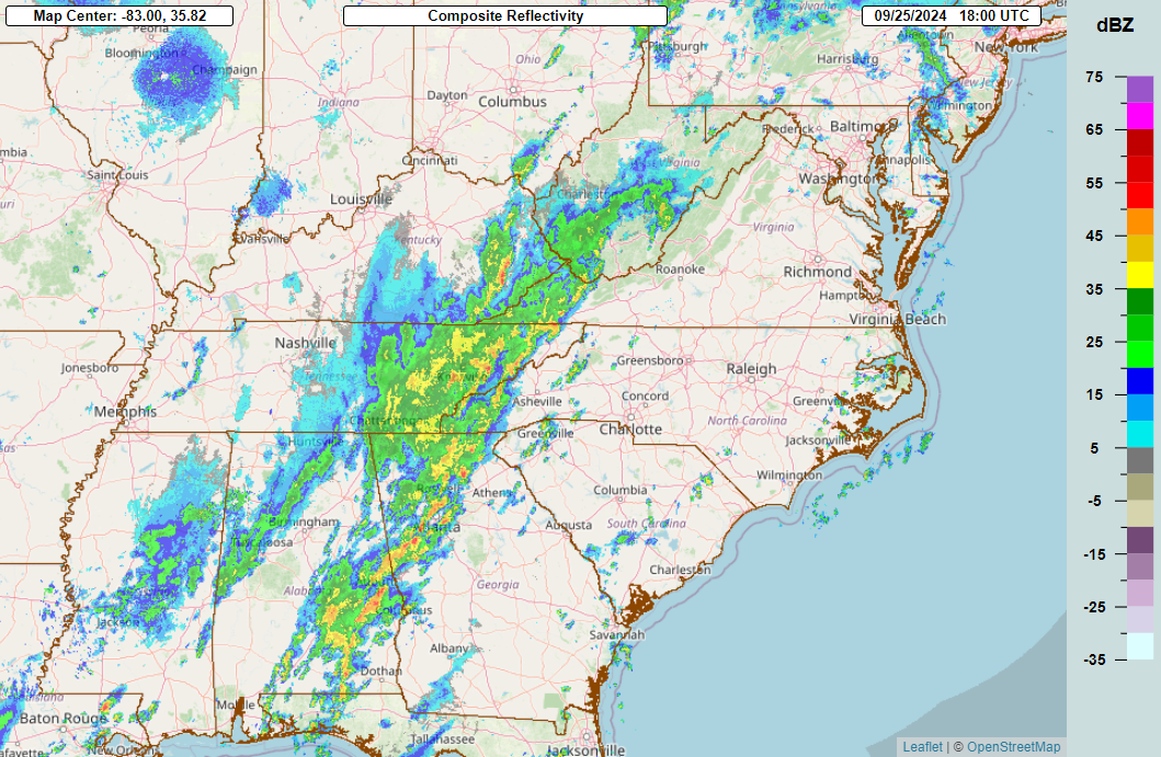
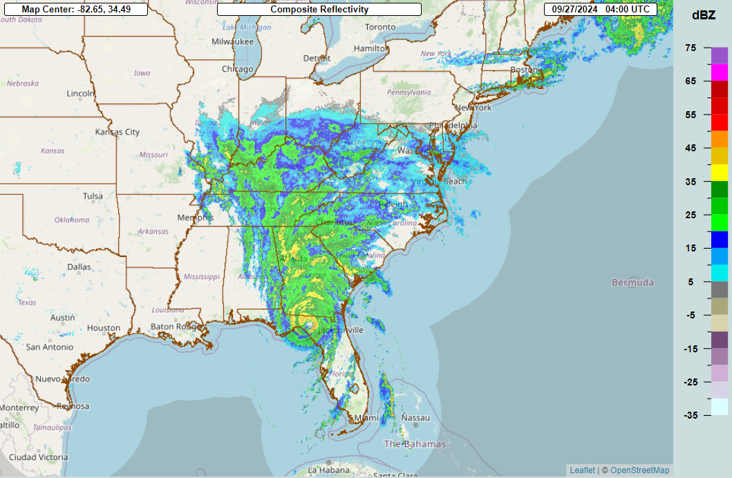
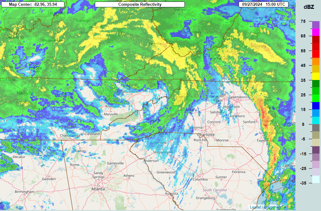
| Heavy rainfall began across the Tennessee Valley and southern Appalachian Mountains on September 25, associated with a slow-moving front | The front stalled across the mountains by midnight on September 26, with a plume of deep moisture spreading northward along the front from the Gulf of America. | Radar estimates of rainfall amounts indicate that 2 to 5 inches of rain had already fallen in East Tennessee and western North Carolina by midnight on September 26, with some locations in North Carolina receiving 5 to 7 inches of rain. | On the afternoon of September 26, radar shows Helene off the west coast of Florida, tracking northward. Meanwhile, moderate rainfall continued across western North Carolina and East Tennessee, associated with the stalled front. |
 |
 |
 |
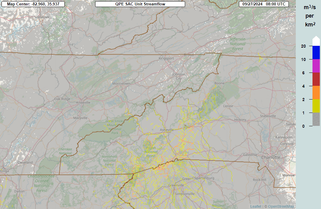 |
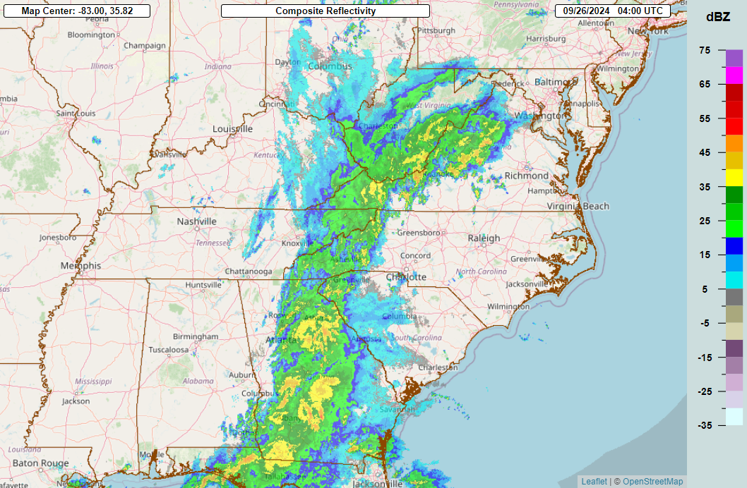
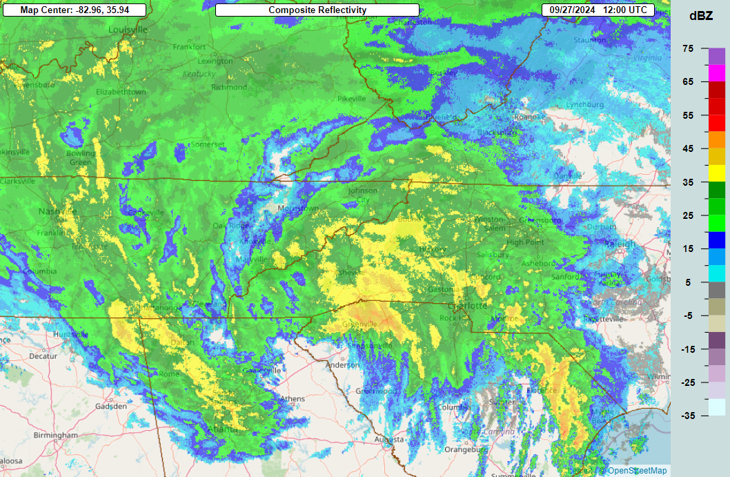
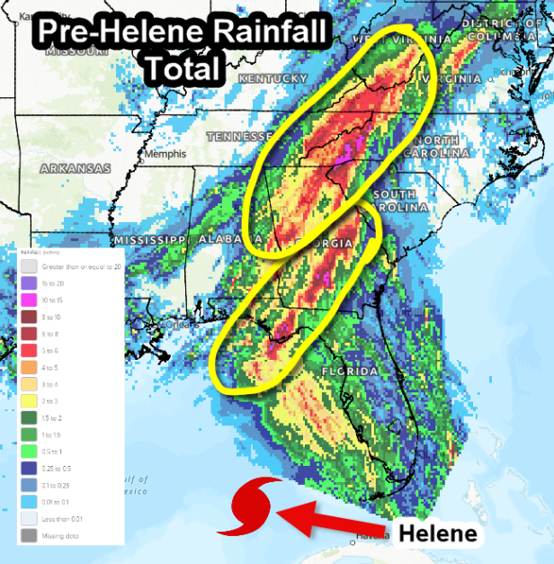
| Just before midnight on September 27, Helene made landfall in the Big Bend region of Florida. Some outer rain bands of Helene appear to be spreading across the Carolinas and Georgia at this time. | Total rainfall estimated by rainfall ahead of Helene was in the range of 6 to 10 inches in the upslope areas of western North Carolina by midnight of September 27. A strengthening easterly flow on the east side of the stalled front and north of Helene encountered the mountains, causing the very moist air to rise and locally enhance rainfall on the eastward facing slopes of the Blue Ridge. | Bands of heavy rainfall associated with Helene spread into western North Carolina on the morning of September 27. | These images are an estimate of the amount of water flowing through rivers and streams based on a radar estimate of rainfall. Rivers and streams in western North Carolina were already running high (yellow and orange) at the start of the animation at midnight on September 27. The streamflow jumps rapidly later that morning as bands of heavy rain associated with Helene spread into the area. |
 |
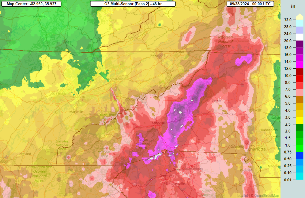 |
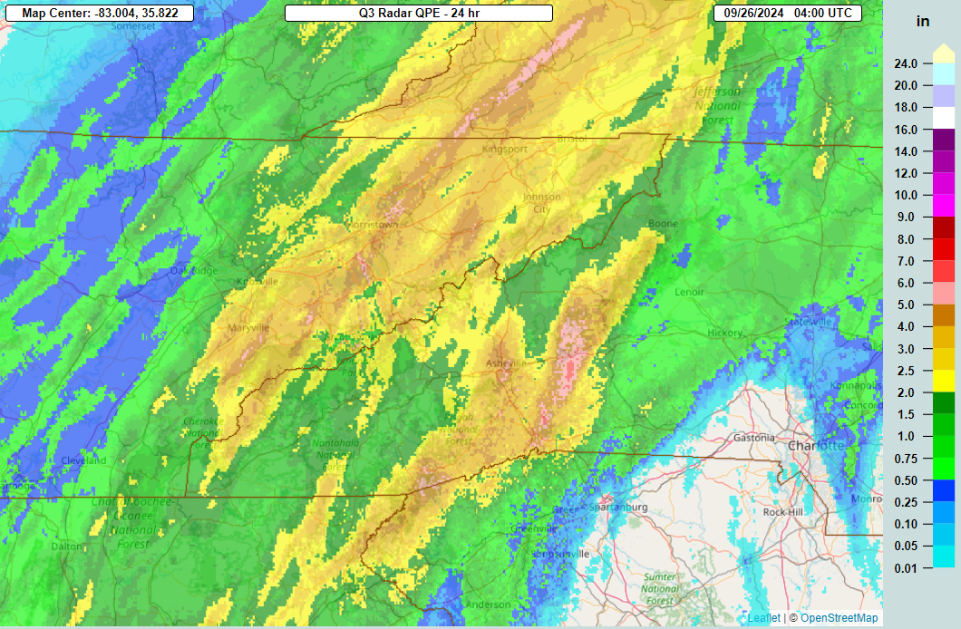
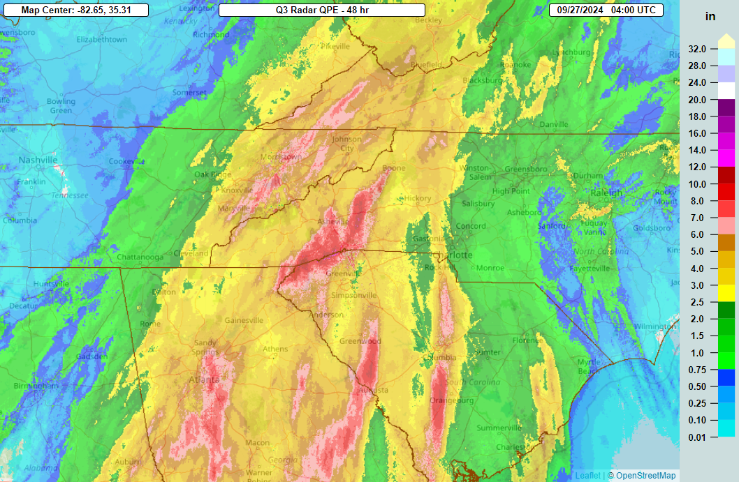
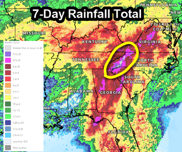
| Even as the center of Helene moves away from the mountains, a band of moderate to heavy rain continues across western North Carolina and northeast Tennessee. | Total 2-day rainfall estimates by radar ending in the evening of September 27 were in the range of 12 to 20 inches in a large swath of western North Carolina, with a few places estimated to be over 20 inches. Many rivers west of the Blue Ridge feed into East Tennessee, so although rainfall amounts were lower there, the flooding was extreme along these rivers. |
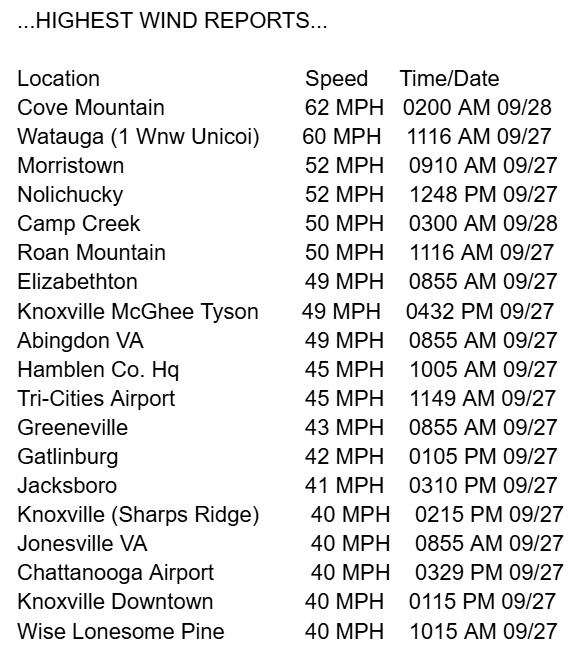
Record Rainfall and Wind Reports
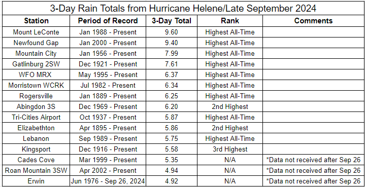
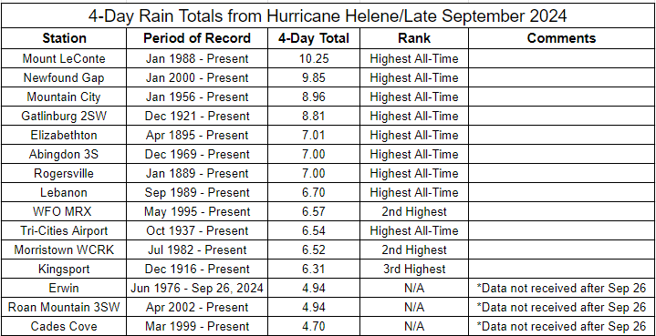
Below are tables with confirmed rainfall reports for 3-day and 4-day periods associated with this event. It should be noted that some reports are missing data because of the extent of devastation. This has been noted in the comments sections. Beyond the rainfall records, there is another table showing the peak wind gust reports.
Environment
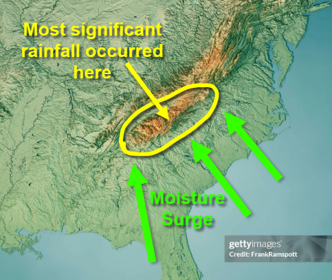
Hurricane Helene produced catastrophic flooding across parts of the Appalachian mountain region of the CONUS. The hardest hit areas were in northeast Tennessee, western North Carolina, and southwest Virginia.
Catastrophic flooding requires a combination of flooding that is exceptionally heavy and exceptionally long-lasting. As Helene interacted with an anomalous closed low over the mid Mississippi valley, moisture feeding towards a stalled cold front across southwest Virginia and east Tennessee allowed a remarkably persistent predecessor rain event.
As Helene was unusually large, intense, and fast-moving, the prolific rain of the storm's extratropical transitioning core was able to follow the Predecessor Rain Event (PRE) with extreme short-duration rain that increased the flash flooding potential. This all happened atop the southern Appalachians mountains, some of the most complex topography in the eastern US; rain intensity was tropical in nature and the heavy rainfall was contributed by the topographical orographic lift.
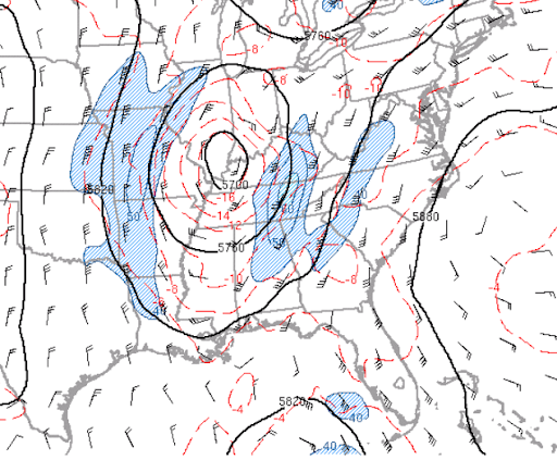 |
 |
 |
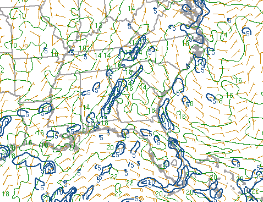
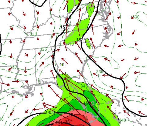
| Figure 1: 500mb Height, Temperature, and Wind at 0000 UTC, September 26th 2024 | Figure 2: 700mb Height, Temperature, Wind and 700-500mb mean Relative Humidity at 0000 UTC, September 26th 2024 | Figure 3: 850mb Height, Temperature, Wind and Dewpoint at 0000 UTC, September 26th 2024 |
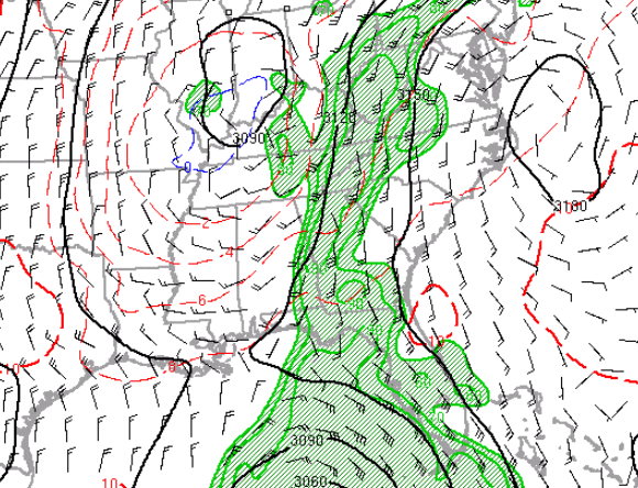
 |
 |
 |
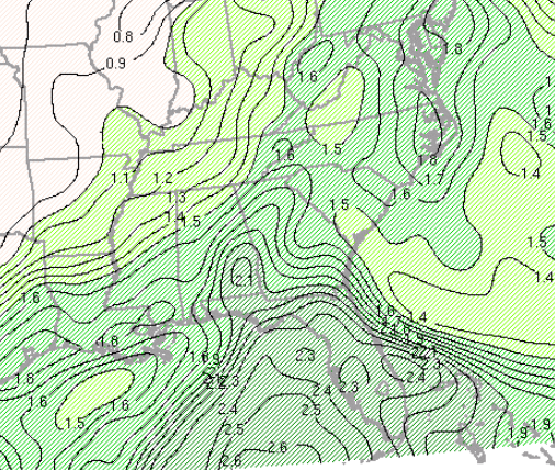
| Figure 4: Surface Moisture Convergence and Mixing Ratio at 0000 UTC, September 26th 2024 | Figure 5: Precipitable Water in the lowest 400mb at 0000 UTC, September 26th 2024 | Figure 6: 850mb Moisture Transport, Height, and Theta-e at 0000 UTC, September 26th 2024 |
PREs are coherent mesoscale regions of heavy rainfall, with rainfall rates ≥4” in 24 hours that can occur approximately 1000 km poleward of recurving tropical cyclones (Cote, 2007). The basic driver of a PRE is that the approaching tropical cyclone interacts with the upper-level wind field and creates a localized area of enhanced upper-level diffluence. There is usually an upper-level moisture plume in-place, and low-level moisture is surged north by the landfalling tropical cyclone. These systems interact, resulting in the extreme rainfall event. Below is a schematic of PREs from Cote’s initial study:
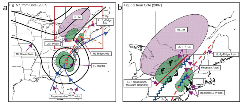 |
The first notable difference between the “typical PRE” schematic a and what took place last week is that the upper level jet was a closed off low and not an open-wave area of troughing. This enhanced the upper-level diffluence, and thus increased the potential for a heavy rainfall event. Worsening the situation was the topography and orientation of both systems in-relation to the topography. Most of the extreme rainfall occurred in the Appalachian Mountains. So not only did you have the upper levels becoming extremely favorable for a heavy rainfall event, but you had a significant “jolt” of vertical motion from the mountains as the tropical moisture surge inland from the southeast and aligned nearly perpendicular to the mountain chain. Schematic B notes an idealized LL wind field relative to mountain chains and the upper-level jet. This event was near “textbook” in that regard.
 |
Both the hurricane and the upper low were responsible for the extreme rainfall that occurred over North Carolina, since either one by themselves would not have resulted in such an extreme event.
The amount of moisture available with Helene was historical To my eye, this was less a case of perfect parameters than well-aligned synoptics, as rain needn't have been extremely heavy at any one time to cause severe flooding given its persistence. Here's a loop of the Wednesday evening GFS from Levi Cowan's Tropical Tidbits, showing a PRE and TC core evolution that was essentially reflected in reality over the following 60 hours.
 |
This is the observed map for September 26th (2 days before Helene’s landfall) when the hurricane was in the Gulf of America, 600-700 miles away. However, there was still a significant amount of rain that fell over the Appalachians and Georgia.
 |
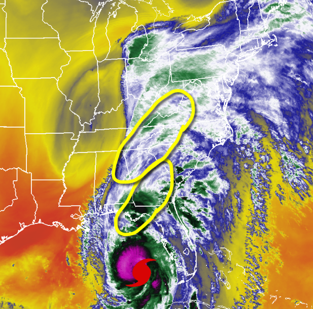
Below is the WV satellite on the 26th. The areas with the heaviest rainfall are circled on the satellite image. It’s easy to identify the hurricane, but note the upper low centered over the Midwest:
 |
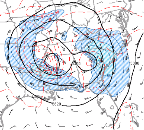
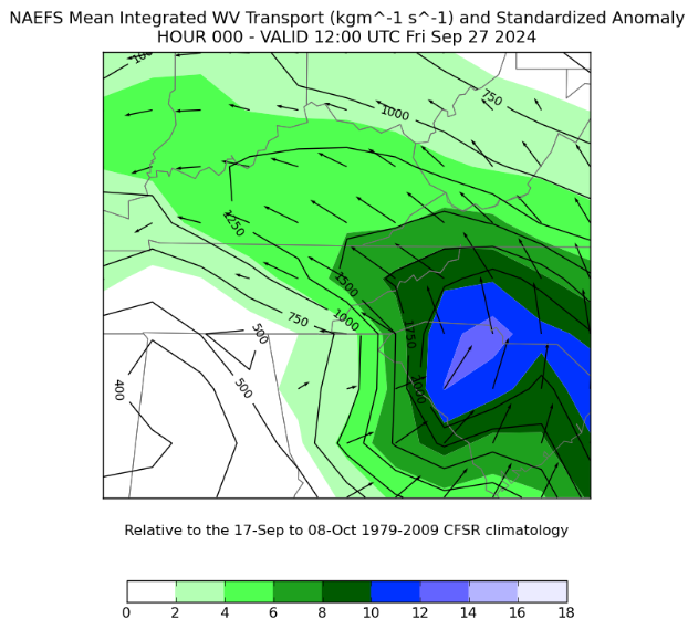
Hurricane Helene Environment
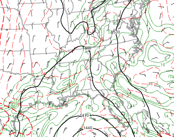
 |
 |
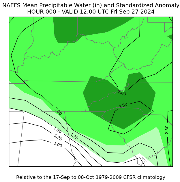 |
| 500mb Height, Temperature, and Wind at 0900 UTC, September 27th 2024 | NAEFS Mean Integrated WV Transport and Standardized Anomaly at 1200 UTC, September 27th 2024 | NAEFS Mean Precipitable Water (in) and Standardized Anomaly at 1200 UTC, September 27th 2024 |
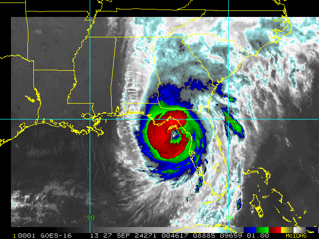 |
| GOES-16 IR Satellite Loop of Hurricane Helene |
 |
Media use of NWS Web News Stories is encouraged! Please acknowledge the NWS as the source of any news information accessed from this site. |
|


 Local Radar
 Huntsville Radar
 Regional Satellite
 Graphical Forecast
 Weather Map