
Severe thunderstorms will be possible over parts of the northern Plains today through Thursday which could bring large hail, damaging winds, and possible tornadoes. Thunderstorms with heavy to excessive rainfall may continue to produce flooding over parts of the southern and northern Plains today. Read More >
Overview
On February 6, 2025, multiple rounds of severe weather occurred across the region, the first being focused further north earlier in the day. By the evening, convection moved into the area from the west ahead of an approaching frontal boundary. Strong shear and sufficient instability allowed for many storms to rotate with two of them producing rare early February tornadoes. The first occurred in western Morgan County, TN near the community of Deer Lodge at EF-2 strength and a track of almost 14 miles. Two people tragically lost their lives, and at least two others were injured. This tornado was the first confirmed February tornado in the Morgan County and the strongest February tornado in our area since 1993. The 2nd tornado occurred in Grainger County, TN near the community of Thorn Hill. It was a high-end EF-1 tornado that tracked nearly 4 miles. For Grainger County, this was only the 4th confirmed tornado in recorded history. These tornadoes were the first February tornadoes in our area since 2011 with only 12 having ever been recorded in that month. Aside from the tornadoes, many areas saw straight line wind damage, hail, and flooding.
Tornadoes:
|
Tornado - Deer Lodge, TN
Track Map 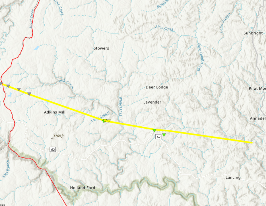 
Downloadable KMZ File |
||||||||||||||||
|
Tornado - Thorn Hill, TN
Track Map 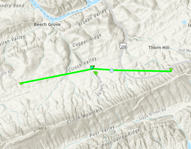
Downloadable KMZ File |
||||||||||||||||
The Enhanced Fujita (EF) Scale classifies tornadoes into the following categories:
| EF0 Weak 65-85 mph |
EF1 Moderate 86-110 mph |
EF2 Significant 111-135 mph |
EF3 Severe 136-165 mph |
EF4 Extreme 166-200 mph |
EF5 Catastrophic 200+ mph |
 |
|||||
Photos & Video
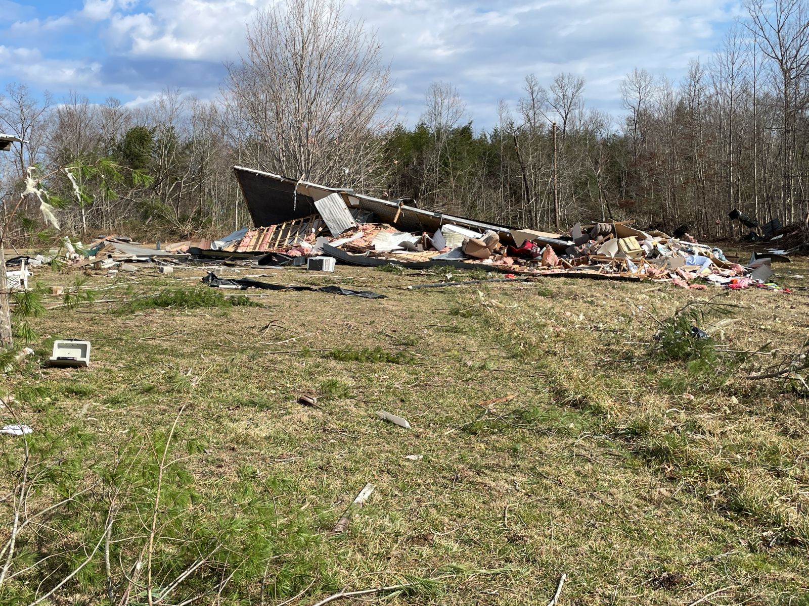
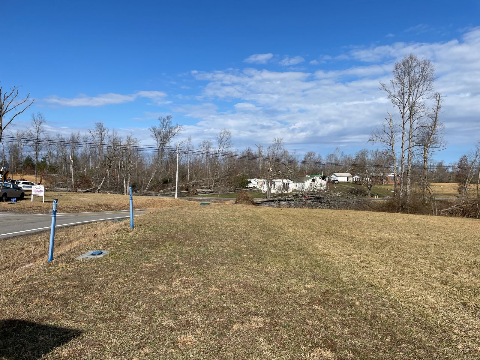
Deer Lodge EF-2
 |
 |
 |
 |
| Manufactured Home Completely Destroyed (NWS Morristown Damage Survey) |
Foundation of Completely Destroyed Manufactured Home (NWS Morristown Damage Survey) |
Complete Destruction of Roof and Walls of another Manufactured Home (NWS Morristown Damage Survey) |
Tree Damage South of Deer Lodge (NWS Morristown Damage Survey) |
 |
| Widespread Tree Damage South of Deer Lodge (NWS Morristown Damage Survey) |
Thorn Hill EF-1
 |
 |
 |
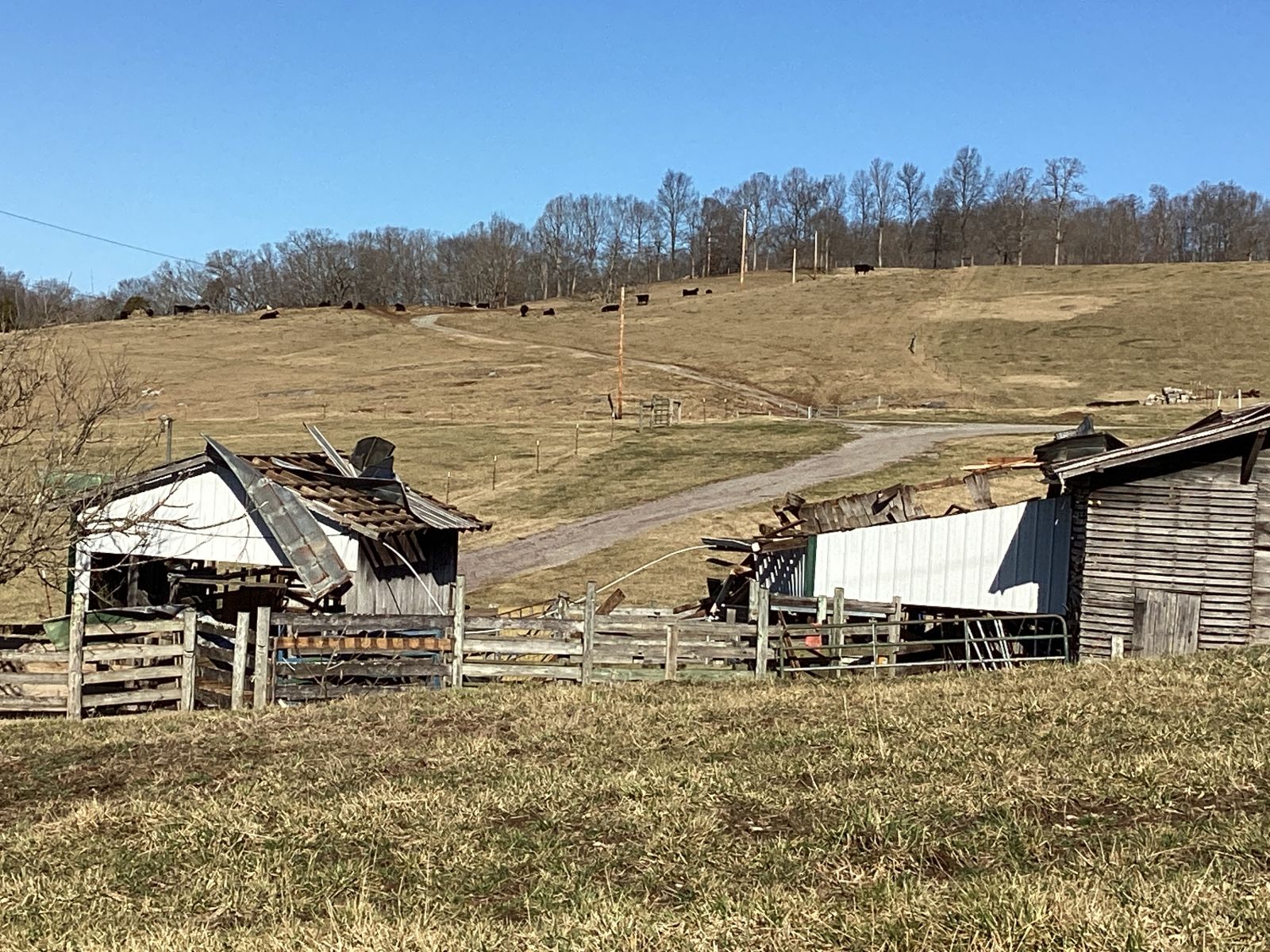
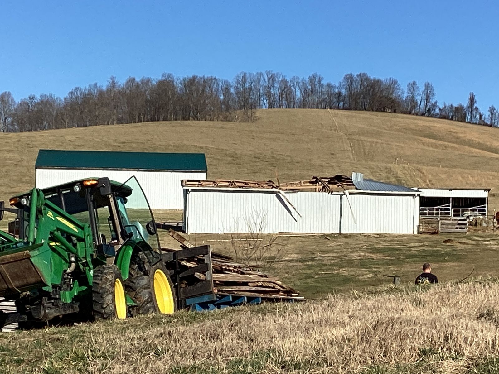
| Damage to Outbuildings (NWS Morristown Damage Survey) |
Damage to Outbuildings (NWS Morristown Damage Survey) |
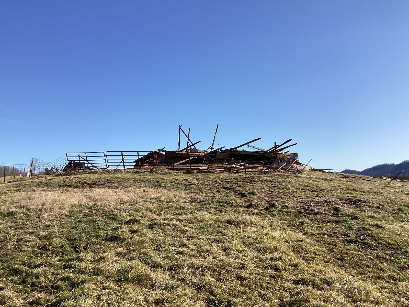
Complete Destruction of Outbuilding (NWS Morristown Damage Survey) |
Hail, Wind Damage, and Flooding
 |
 |
 |
 |
| Hail in Kodak, TN (Courtesy: WATE-TV) |
Hail in Kodak, TN (Courtesy: WATE-TV) |
Wind Damage in Sevier County (Courtesy: WATE-TV) |
Flooding in Kodak, TN
(Courtesy: WATE-TV)
|
Radar
 |
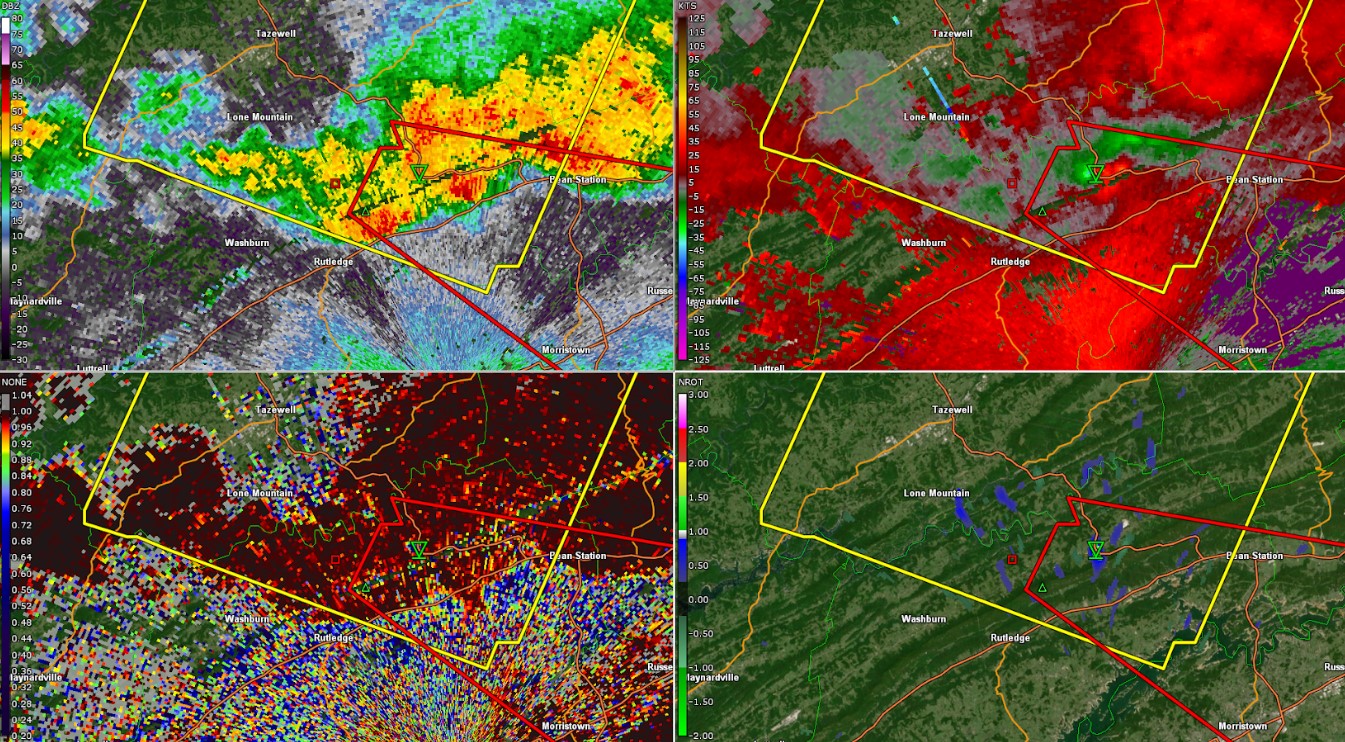 |
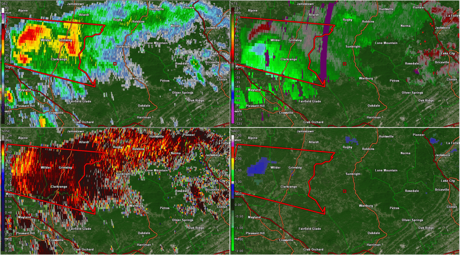 |
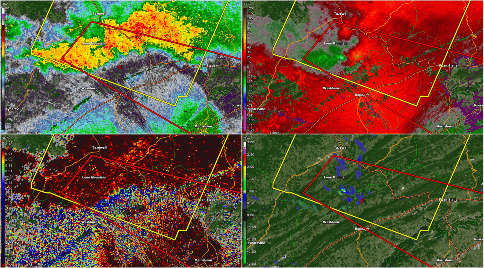 |
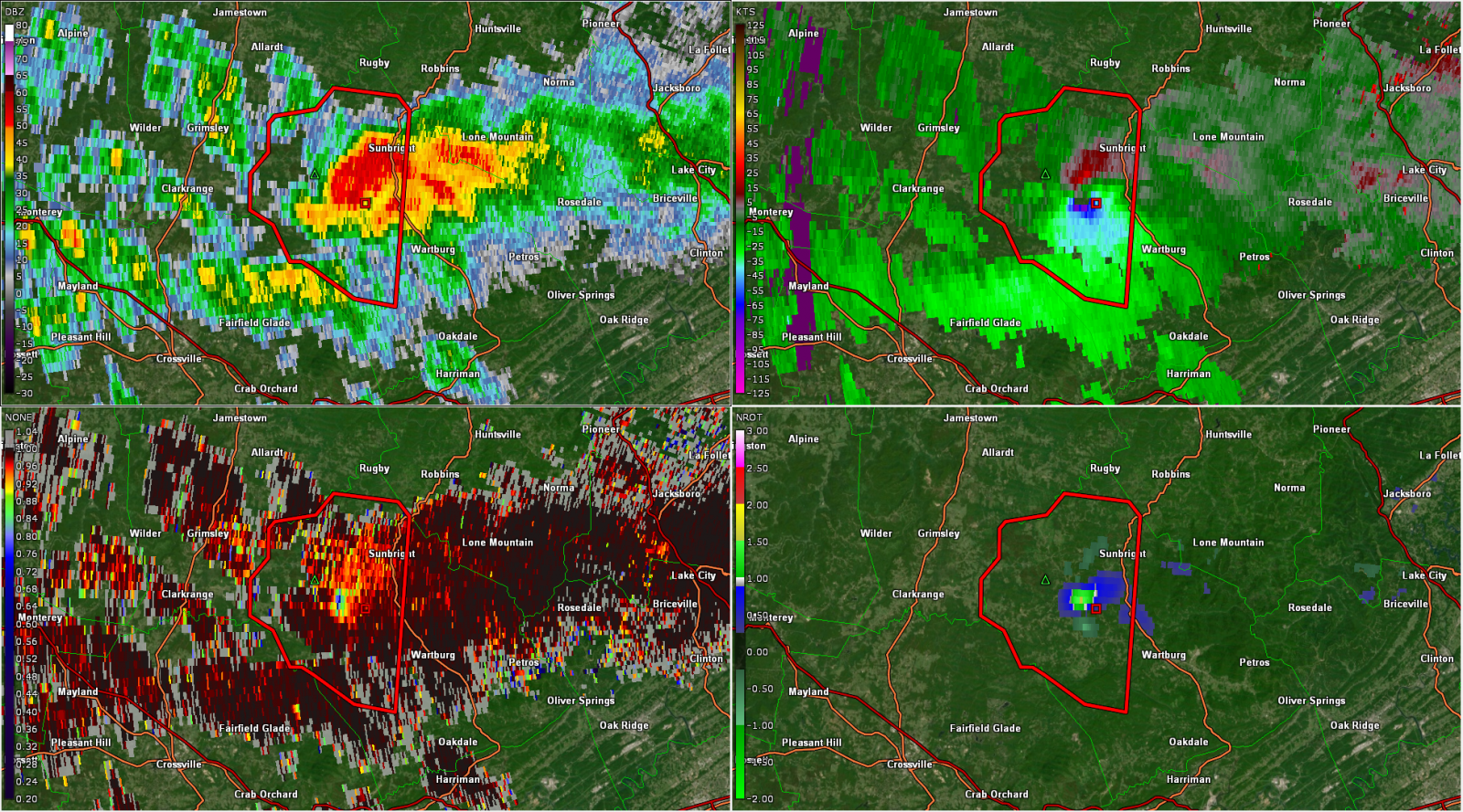
| (From Top-Left Clockwise): Base Reflectivity, Velocity, Normalized Rotation, and Correlation Coefficient at 8:17 PM EST | (From Top-Left Clockwise): Base Reflectivity, Velocity, Normalized Rotation, and Correlation Coefficient at 9:29 PM EST | Radar Loop of the Deer Lodge Tornado | Radar Loop of the Thorn Hill Tornado |
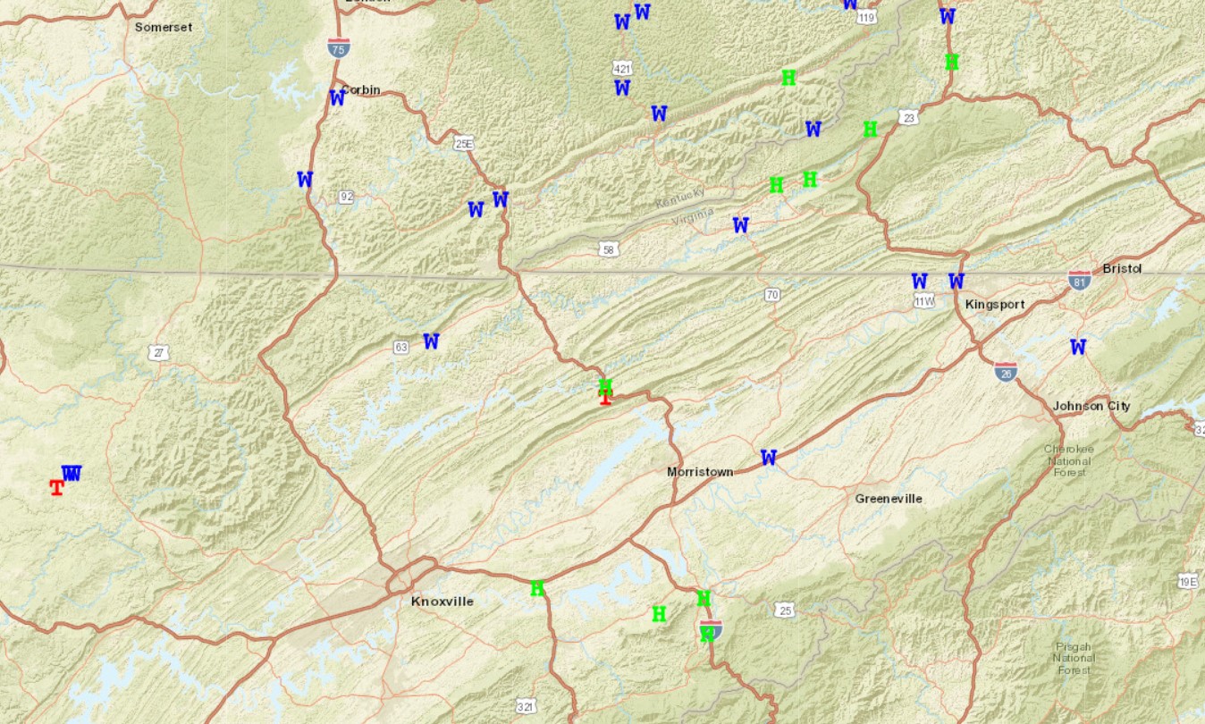
Storm Reports
Preliminary Local Storm Report...Summary
National Weather Service Morristown TN
1035 AM EST Fri Feb 7 2025
..TIME... ...EVENT... ...CITY LOCATION... ...LAT.LON...
..DATE... ....MAG.... ..COUNTY LOCATION..ST.. ...SOURCE....
..REMARKS..
1155 PM Flash Flood 4 SSE Newport 35.90N 83.16W
02/06/2025 Cocke TN Law Enforcement
Several roadways are flooded across southern
Cocke county.
1102 PM Hail 5 NNW Hartford 35.88N 83.19W
02/06/2025 E1.00 Inch Cocke TN Public
1100 PM Flash Flood 1 NNE Kodak 35.99N 83.62W
02/06/2025 Sevier TN Emergency Mngr
Sevier County EM reported instances of flash
flooding near Snyder and Hardin roads as
well as along western portions of Douglass
Dam road. Time estimated by radar.
1100 PM Flash Flood 4 E Kodak 35.97N 83.56W
02/06/2025 Sevier TN Emergency Mngr
Sevier County EM reports multiple instances
of flash flooding on SR 139 along Douglas
Lake as well standing water on an athletic
field at Northview Academy just off Winfield
Dunn Parkway. Time estimated by radar.
1050 PM Flash Flood 3 N Kodak 36.02N 83.64W
02/06/2025 Sevier TN Law Enforcement
Several roadways are flooded across northern
Sevier county near Kodak.
1029 PM Tstm Wnd Dmg 1 SSW Bluff City 36.45N 82.28W
02/06/2025 Sullivan TN Public
A few trees down.
1000 PM Hail 1 SSW Newport 35.95N 83.20W
02/06/2025 E1.75 Inch Cocke TN Public
Social media photo of large hail that caused
vehicle damage, estimated at least golf ball
sized and time estimated from radar.
0955 PM Tstm Wnd Dmg 2 NNE Mohawk 36.23N 83.04W
02/06/2025 Greene TN Law Enforcement
Several trees down.
0950 PM Tstm Wnd Dmg 4 NNW Kingsport 36.58N 82.58W
02/06/2025 Sullivan TN Public
Social media photo of a tree that fell on a
car in northern Kingsport. Time is estimated
from radar.
0950 PM Hail 2 SE Chestnut Hill 35.92N 83.31W
02/06/2025 M1.00 Inch Jefferson TN Public
Time estimated from radar.
0940 PM Hail 1 E Kodak 35.97N 83.61W
02/06/2025 E1.75 Inch Sevier TN Public
Social media photo of large hail estimated
to be at least golf ball sized. Time
estimated from radar.
0935 PM Tstm Wnd Dmg 1 NNW Mount Carmel 36.58N 82.67W
02/06/2025 Hawkins TN Law Enforcement
Several trees down.
0926 PM Tornado 1 WSW Thorn Hill 36.35N 83.44W
02/06/2025 Grainger TN NWS Storm Survey
The tornado began near McAnally Rd and Campground Rd before
moving east along Highway 131. There were several barns and outbuildings
with roof damage, and numerous snapped trees. The most significant
damage was to a large barn on Highway 131 that was completely destroyed.
Damage continued to around Clinch River Hardwoods and Thorn Hill Church.
A large tanker trailer was overturned, and the church had some light
damage to siding and windows. The path ended where trees were snapped
on the side of Clinch Mountain near Highway 25E.
0925 PM Hail 1 NW Thorn Hill 36.37N 83.44W
02/06/2025 E1.25 Inch Grainger TN Public
Several trees down as well.
0910 PM Tstm Wnd Dmg Jonesville 36.69N 83.11W
02/06/2025 Lee VA Public
Several trees down.
0847 PM Tstm Wnd Dmg Speedwell 36.46N 83.87W
02/06/2025 Claiborne TN Public
A few trees down.
0840 PM Tstm Wnd Dmg 2 SSE Pound 37.10N 82.60W
02/06/2025 Wise VA Public
Several trees down.
0825 PM Tstm Wnd Dmg 1 E Deerlodge 36.20N 84.75W
02/06/2025 Morgan TN Public
Several homes damaged and trees down.
Possible tornado.
0804 PM     Tornado          2 SW Deerlodge          36.17N 84.79W
02/06/2025                   Morgan             TN   NWS Storm Survey

            *** 2 FATAL, 2 INJ ***
            Tornado may have started in southeast
            Fentress County (pending OHX survey) before
            tracking into forested areas of Morgan
            County that were inaccessible to the survey
            team. The tornado moved southeast where it
            produced EF-2 damage, destroyed two mobile
            homes, and damaged multiple barns and
            outbuildings near the intersection of Twin
            Bridge Rd and Thurman Lavender Rd. As the
            tornado continued southeast, it snapped the
            top of trees consistent with EF-1 damage
            near the convergence of Highway 62 and Deer
            Lodge Highway. The tornado continued
            southeast into forested areas inaccessible
            to the survey team before dissipating prior
            to Highway 27.
0535 PM     Hail             2 NNW Wise              37.01N 82.59W
02/06/2025  E1.50 Inch       Wise               VA   Law Enforcement


0530 PM     Hail             Dryden                  36.78N 82.94W
02/06/2025  M1.50 Inch       Lee                VA   Law Enforcement


0520 PM     Hail             Pennington Gap          36.77N 83.02W
02/06/2025  E1.25 Inch       Lee                VA   Public

            Corrects previous hail report from 2 S
            Appalachia.
Storm Reports Map
W - Damaging Winds
H - Hail
T - Tornado
Environment
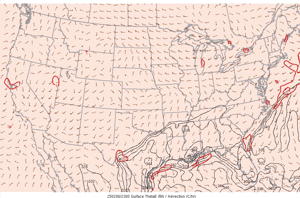
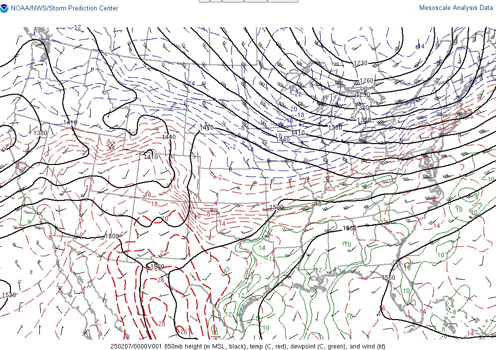
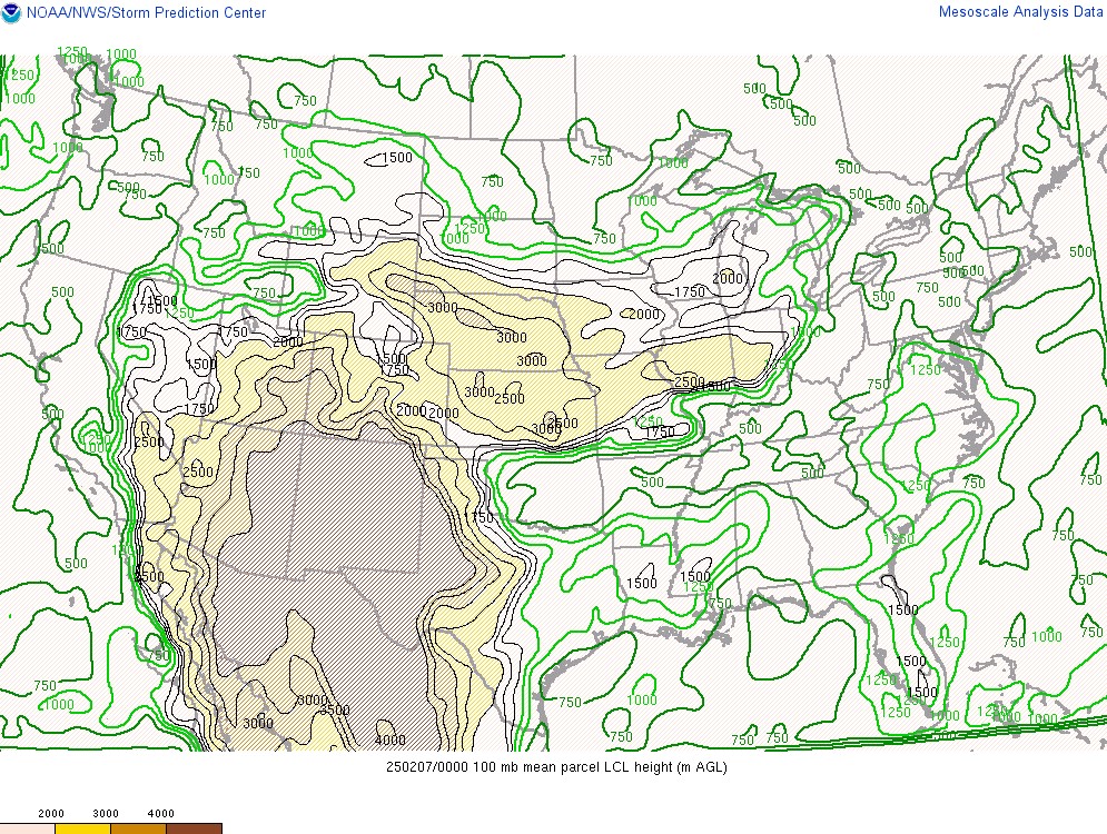
The environment across the Mid-South region featured a cold front across Kentucky that was moving southward (Figure 1). Above the surface at 850 mb, a southwesterly low level jet of 30-50 kt was across Middle Tennessee and the Cumberland Plateau (Figure 2). This low level jet brought enhanced moisture transport into Middle and East Tennessee (Figure 3). Because of this low level moisture transport, the LCL height (lifted condensation level) was low, 500 m or less, which is favorable for tornadoes (Figure 4).
 |
 |
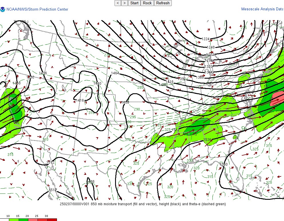 |
| Figure 1: Theta-E and Surface Winds at 6:00 PM EST | Figure 2: 850mb Heights, Winds, Temperatures and Dew Points at 7:00 PM EST | Figure 3: 850mb Moisture Transport at 7:00 PM EST |
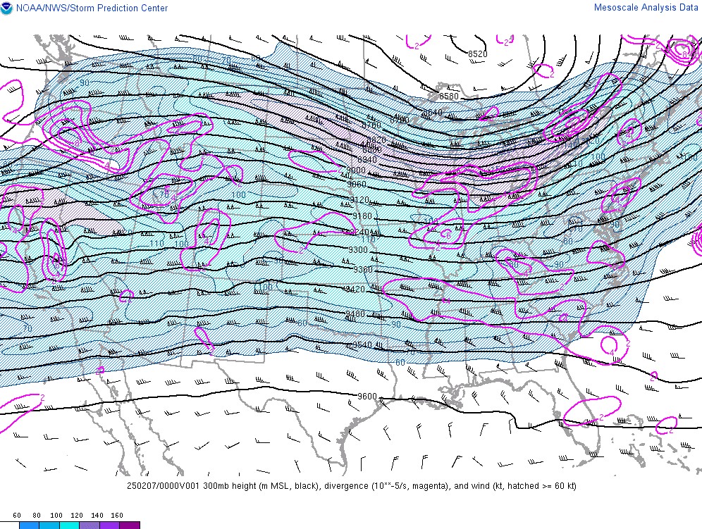
Higher in the atmosphere, there were not a lot of notable features, with a broad trough across the eastern United States. Winds were divergent in the upper levels at 300 mb (Figure 5), which likely helped support storm development and intensification.
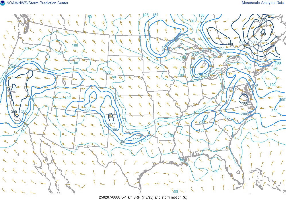
Shear was plentiful in southern Kentucky, Middle Tennessee, and western portions of East Tennessee, with bulk shear values of 50 kt (Figure 6) supporting rotating updrafts. Low level (0-1 km) storm-relative helicity values also indicated an environment capable of producing tornadoes (Figure 7).
 |
 |
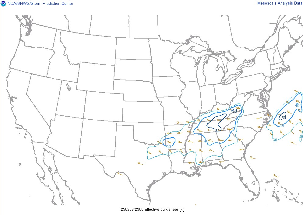 |
| Figure 4: LCL Heights at 7:00 PM EST | Figure 5: 300mb Heights, Winds, and Divergence at 7:00 PM EST | Figure 6: Effective Bulk Shear at 6:00 PM EST |
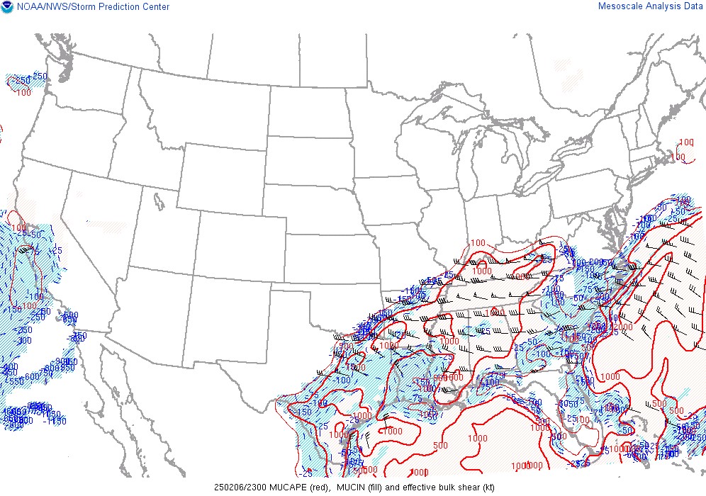
In February, it is rare to get high levels of instability in the atmosphere, measured by CAPE (Convective Available Potential Energy). CAPE on this day was higher than we would typically expect for early February, in the range of 500-1000 J/kg in East and Middle Tennessee, with just over 1000 J/kg in eastern Kentucky (Figure 8). CAPE in the lowest levels of the atmosphere (0-3 km) was particularly high, above 50 J/kg, and it aligned in the same area as the high shear values (Figure 9).
 |
 |
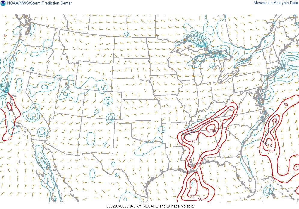 |
| Figure 7: 0-1km Storm-Relative Helicity at 6:00 PM EST | Figure 8: MUCAPE and Effective Shear at 6:00 PM EST | Figure 9: 0-3km CAPE and Surface Vorticity at 6:00 PM EST |
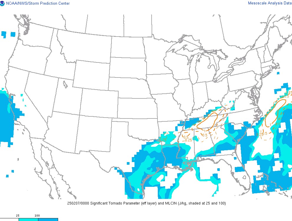
Several composite parameters pointed toward an environment favorable for large hail and tornadoes. Composite parameters combine different elements of the atmosphere, like instability and shear, into one parameter to help diagnose different weather threats, like tornadoes. The Significant Tornado Parameter (STP) was over 1, suggesting that EF2 tornadoes or stronger were possible (Figure 10).
Large hail was also a threat this day, as indicated by instability in the midlevels of the atmosphere. By looking at CAPE at the height where hail forms (between -10 C to -30 C), we can tell if large hail will be a threat. On this day, these CAPE values in that layer were favorable for hail, between 400 and 500 J/kg. With these values overlapping with high shear, large hail was able to form in the strong, rotating updrafts of the storms (Figure 11).
 |
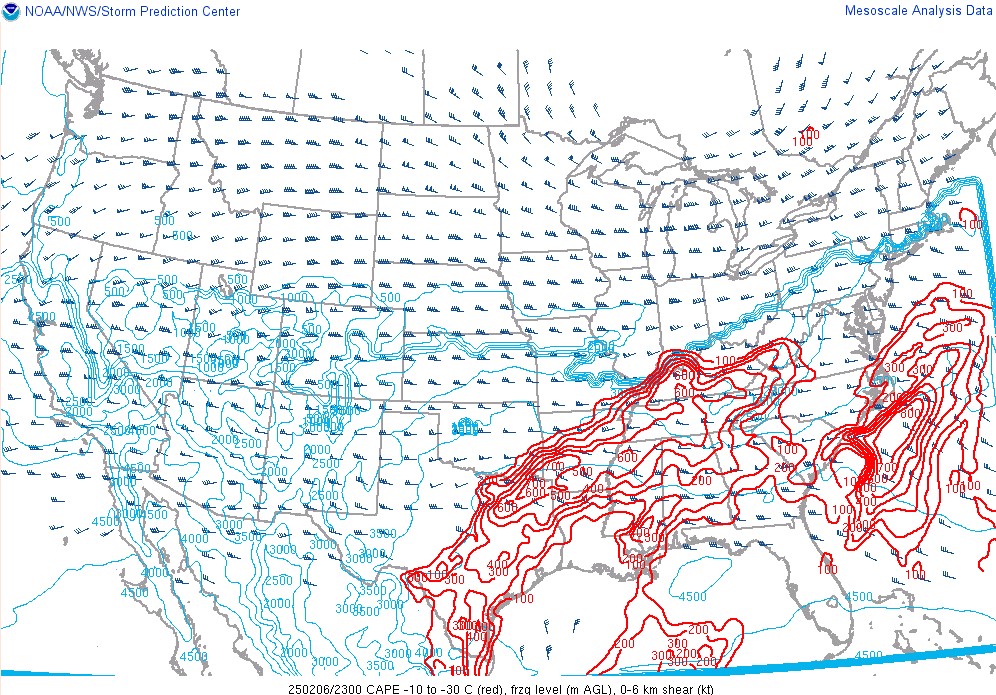 |
| Figure 10: STP at 7:00 PM EST | Figure 11: CAPE from the -10C to -30C Level |
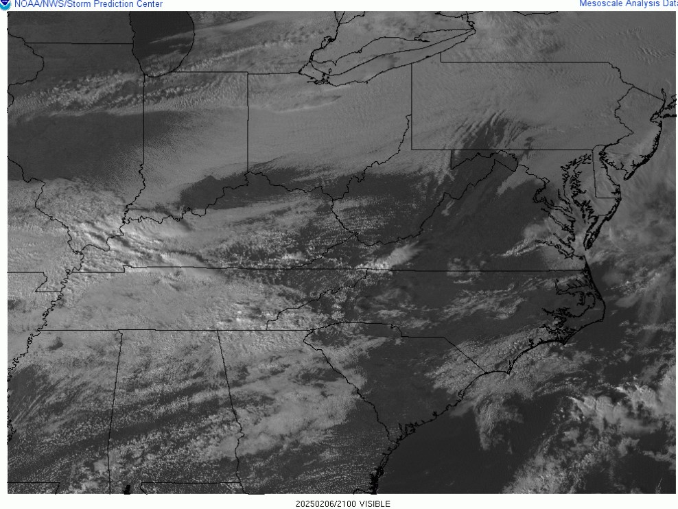
An important feature in East and Middle Tennessee was a boundary that was formed due to differential cloud cover across the area. In the satellite image below (Figure 12), there is a large area of overcast clouds from around Clarksville, southeast to around Knoxville. North of this cloud cover, it is mostly sunny with scattered cumulus clouds, indicating an unstable low level atmosphere. Storms are starting to develop in southeast Kentucky at this time (4 PM EST), and in western Kentucky.
Surface observations at 4 PM EST showed the difference in temperature between the area of cloud cover and the mostly sunny area. Temperatures in Kentucky and northern East Tennessee were in the lower 70s, while areas under the cloud cover in Middle Tennessee were in the mid to upper 60s. The boundary location is indicated by the red dashed line (Figure 13). Later in the evening, the storms in western Kentucky would ride along this boundary, including the long-lived supercell thunderstorm that produced the Morgan County tornado and large hail in Kodak and Newport.
 |
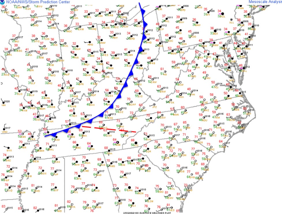 |
| Figure 12: Visible Satellite at 4 PM EST | Figure 13: Surface Observations at 4 PM EST |
 |
Media use of NWS Web News Stories is encouraged! Please acknowledge the NWS as the source of any news information accessed from this site. |
|


 Local Radar
 Huntsville Radar
 Regional Satellite
 Graphical Forecast
 Weather Map