TROPICAL PRODUCTS
TROPICAL CYCLONE PUBLIC ADVISORY (TCP)
-Issued by the National Hurricane Center
-Provides critical hurricane warning and forecast information (i.e., current position and motion, maximum sustained winds, minimum pressure, storm tides, tornado and flash flood potential).
TROPICAL CYCLONE DISCUSSION (TCD)
-Issued by the National Hurricane Center
-Provides reasoning for analysis and forecast of the tropical cyclone.
TROPICAL CYCLONE MARINE ADVISORY (TCM)
-Issued by the National Hurricane Center
-Provides detailed hurricane track and wind field information (i.e., wind radii for 12, 24, 36, 48 and 72 hours).
TROPICAL CYCLONE UPDATE (TCU)
-Issued by the National Hurricane Center
-Highlights significant changes in a hurricane that occur between advisories.
TROPICAL WEATHER OUTLOOK (TWO)
-Issued by the National Hurricane Center
-Discussion of significant areas of disturbed weather and potential for development out to 5 days.
HURRICANE LOCAL STATEMENT (HLS)
-Issued by National Weather Service Mobile/Pensacola
-Gives greater detail on how the storm will impact the local area.
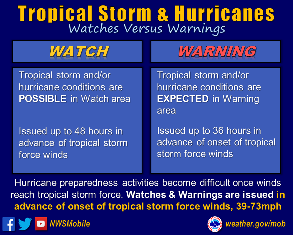
TROPICAL STORM WATCH
-Issued by National Weather Service Mobile/Pensacola
-Tropical Storm conditions are POSSIBLE in the specified area of the Watch, usually within 48 hours.
TROPICAL STORM WARNING
-Issued by National Weather Service Mobile/Pensacola
-Tropical Storm conditions are EXPECTED in the specified are of the Warning, usually within 36 hours.
HURRICANE WATCH
-Issued by National Weather Service Mobile/Pensacola
-Hurricane conditions are POSSIBLE within the specified area of the Watch. Because hurricane preparedness activities become difficult once winds reach tropical storm force, the Watch is issued 48 hours in advance of the onset of tropical storm force winds.
-Prepare to take immediate action to protect your family and property in case a Hurricane Warning is issued.
HURRICANE WARNING
-Issued by National Weather Service Mobile/Pensacola
-Hurricane conditions are EXPECTED somewhere within the specified area of the Warning. Because hurricane preparedness activities become difficult once winds reach tropical storm force, the Warning is issued 36 hours in advance of the onset of tropical storm force winds.
-Hurricane Warnings can remain in effect when dangerously high water and waves continue, even though winds may be less than hurricane force.
-Complete all storm preparations and evacuate if directed by local officials.
INLAND HURRICANE WARNING
-Issued by National Weather Service Mobile/Pensacola
-When hurricane force winds are EXPECTED to occur beyond coastal areas outside the traditional hurricane warning area (along the immediate coast).
EXTREME WIND WARNING (EWW)
-Issued by National Weather Service Mobile/Pensacola
-Extreme sustained surface winds of 115 mph (110 knots) or greater from a MAJOR HURRICANE (Category 3, 4 or 5) are EXPECTED within the hour.
-Usually associated with the eyewall of a hurricane.
-Take shelter in an interior portion of your initial hurricane shelter
NEW!! STORM SURGE WATCH/WARNING
-Experimental prototype storm surge graphics: 2015 season
-Experimental Watch/Warning: 2016 season
-Operational Watch/Warning: 2017 season
Storm Surge WATCH
-The possibility of life-threatening inundation from rising water moving inland from the shoreline somewhere within the specified area of the Watch, generally within 48 hours.
-Watch may be issued earlier when other conditions, such as the onset of tropical-storm-force winds are expected to limit the time available to take protective actions for surge (e.g., evacuations).
Storm Surge WARNING
-The danger of life-threatening inundation from rising water moving inland from the shoreline somewhere within the specified area of the Warning, generally within 36 hours.
-Warning may be issued earlier when other conditions, such as the onset of tropical-storm-force winds are expected to limit the time available to take protective actions for surge (e.g., evacuations).
-Warning can be issued for locations not expected to receive life-threatening inundation but which could potentially be isolated by inundation in adjacent areas.
SHORT TERM WATCHES and WARNINGS
-Provide detailed information on specific hurricane threats, such as severe thunderstorms, tornadoes and flash flooding.
For further explanations, go to the National Hurricane Center page on
Tropical Cyclone Text Product Descriptions.


