Hurricane Flossy - September 24, 1956
 Flossy began as a well-developed circulation over the Yucatan Peninsula on September 21st. The disturbance continued to organize and grow as it moved northward into the Gulf. By the 22nd of September, Flossy strengthened into a tropical storm. Flossy continued to strengthen and gained hurricane status on the 23rd of September in 1956.
As Flossy strengthened, it began to turn to the east-northeast and clipped the mouth of the Mississippi River in the early morning hours on the 24th of September. Flossy made a second landfall as a Category 1 Hurricane near Fort Walton Beach and Destin in far southeastern Okaloosa County, FL late in the evening on September 24th, 1956.
Hurricane Flossy was the only hurricane to make landfall in the contiguous United States during the 1956 Atlantic Hurricane Season. After making landfall, Flossy quickly weakened to a tropical storm and then extratropical as it progressed east-northeast out of the area. A map of the track of Flossy and accompanying observations along the path and boundary of hurricane force winds can be seen in the graphic below (courtesy of NOAA AOML/HRD).
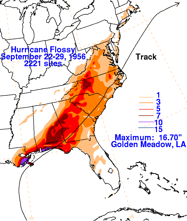
Since Flossy moved along the coast before making landfall, heavy rainfall was the biggest impact across the region, which can be seen in the storm total rainfall image to the right (courtesy of NOAA WPC). An estimated 10-15 inches (with isolated higher amounts) occurred across Mobile and Baldwin Counties in Alabama and across Escambia, Santa Rosa, and Okaloosa Counties in northwest Florida. The highest rainfall amount reported across the area was 16.30 inches in Gulf Shores, AL.
Additional Information
RESEARCH
The Transformation of Hurricane Flossy into an Extratropical Cyclone, September 25-29, 1956 - Monthly Weather Review
Authors: D.A. Richter and E.A. DiLoreto (National Weather Analysis Center
WPC Archive
Monthly Weather Review - Atlantic Hurricane Season of 1956
NOAA Digital Coast - Hurricane Flossy Track
Acknowledgements: Page created by Morgan Barry (forecaster).
LAST UPDATED: September 2018