The National Weather Service (NWS) office in Mobile-Pensacola will be implementing changes to the Coastal Waters Forecast (CWF) product on December 5, 2017, coincident on the same day that the new marine zone configuration is scheduled to take effect. Users of the CWF product will notice the following changes:
1. References of wave state (smooth, light chop, choppy, etc.) in the bays, sounds, and coastal waterways marine zones will be replaced with wave height information. The associated marine zones that will be affected by this change include: Northern Mobile Bay (GMZ630), Southern Mobile Bay (GMZ631), Mississippi Sound east of Pascagoula (GMZ632), Perdido Bay (GMZ633), Pensacola Bay System (GMZ634), Western Choctawhatchee Bay (GMZ635), and Eastern Choctawhatchee Bay (GMZ636).
2. Dominant wave period and swell direction will be added to the Alabama and northwest Florida panhandle coastal Gulf waters out 60 nautical miles. The affected marine zones include: Coastal Waters From Pensacola FL to Pascagoula MS out 20 NM (GMZ650), Coastal Waters From Okaloosa-Walton County Line FL to Pensacola FL out 20 NM (GMZ655), Coastal Waters From Pensacola FL to Pascagoula MS 20 to 60 NM out (GMZ670), and Coastal Waters From Okaloosa-Walton County Line FL to Pensacola FL from 20 to 60 NM (GMZ675).
Figure 1 below displays a map of the new NWS Mobile-Pensacola marine zone configuration that will be implemented on December 5, 2017.
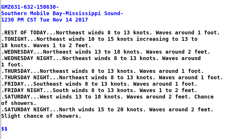
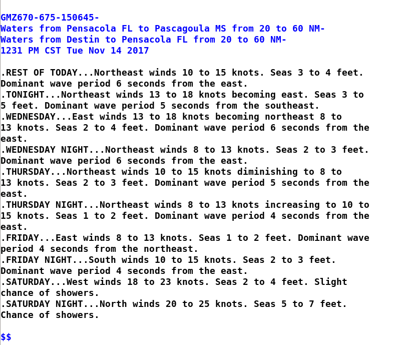
Examples of the new CWF format for bays, sounds, and coastal waterways and the offshore coastal waters marine zones are also provided in Figures 2 and 3 below.

Figure 1: Map of the new NWS Mobile-Pensacola marine zone configuration slated to become effective December 5, 2017. Bays, sounds, and coastal waterways marine zones include: Northern Mobile Bay (GMZ630), Southern Mobile Bay (GMZ631), Mississippi Sound east of Pascagoula (GMZ632), Perdido Bay (GMZ633), Pensacola Bay System (GMZ634), Western Choctawhatchee Bay (GMZ635), and Eastern Choctawhatchee Bay (GMZ636). The offshore marine zones include: Coastal Waters From Pensacola FL to Pascagoula MS out 20 NM (GMZ650), Coastal Waters From Okaloosa-Walton County Line FL to Pensacola FL out 20 NM (GMZ655), Coastal Waters From Pensacola FL to Pascagoula MS 20 to 60 NM out (GMZ670), and Coastal Waters From Okaloosa-Walton County Line FL to Pensacola FL from 20 to 60 NM (GMZ675).

Figure 2: Example of the updated Coastal Waters Forecast format for the bays, sounds, and coastal waterways marine zones that will take effect on December 5, 2017. Forecast information will include wind direction and speed, wave height, and significant weather (fog, chance of precipitation, etc.). Wave state wording (smooth, light chop, choppy) will be replaced with wave height information.

Figure 3: Example of the updated Coastal Waters Forecast format for one of the offshore coastal waters marine zones scheduled to take effect on December 5, 2017. Forecast information will include wind direction and speed, significant wave height, significant weather (fog, chance of precipitation, etc.), dominant wave period and swell direction.
Questions and comments regarding these changes are welcome. Please contact:
Jeffrey Medlin, Meteorologist in Charge - Jeff.Medlin@noaa.gov or
Cody Lindsey, Marine Program Leader - Cody.Lindsey@noaa.gov
(251) 633-6443