September 2022 Climate Summaries
Mobile Alabama and Pensacola Florida Area
National Weather Service Mobile Alabama
October 3, 2022
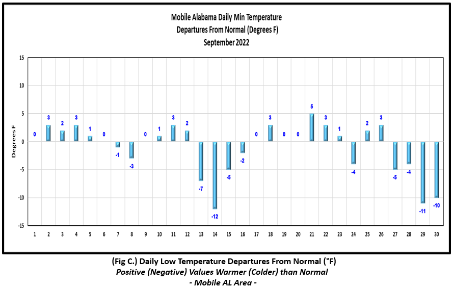
September 2022 in Review - Following an excessively wet, well above normal monthly rainfall from August, September's rainfall story was on the other side of the spectrum being unseasonably dry for the month. As far as temperatures, September started off near seasonal on highs and lows the first of the week then a brief "cool" down was experienced entering the second week with the first noticeable touch of Fall occurring on the morning of the 14th when lows dipped down to 7° and 12° below normal respectively at Mobile and Pensacola. Following, as is common on the Gulf coast, a swing back to above normal temperatures ensued to open up the latter half of the month where daily highs averaged 3 to 6° above normal between the 15th and 26th. A new daily record high was set during the period at both Mobile and Pensacola. Then, as major Hurricane Ian moved north northeast across the southern and central Florida peninsula to close out the month combined with the passage of a strong cold front, temperatures tumbled the last few days of the month bringing another round of Fall like temperatures to the central Gulf coast. Morning lows on the 29th and 30th dipped into the mid to upper 50's, or near 10° below average at both Mobile and Pensacola.
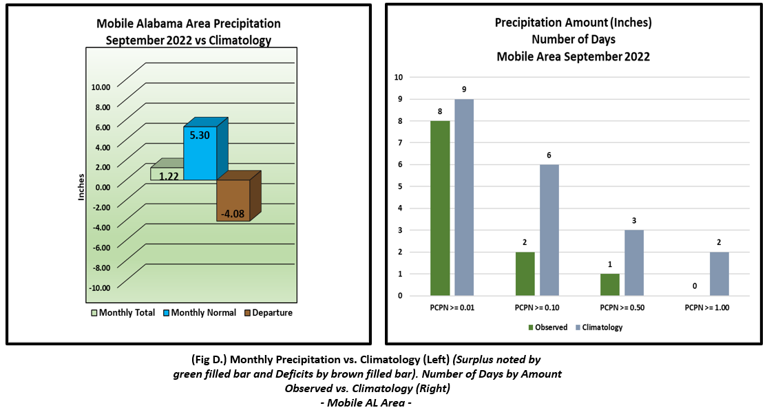
As mentioned earlier, monthly total precipitation for September was way down; monthly values collected in the rain gauge were less than 2.25" at both sites, shy by several inches off the normals. Of note, September 2022 rainfall for the Mobile area was just outside making it into the top 10 driest Septembers on record. Despite the excessive monthly rains observed in August, the lengthy dry spell in September has brought about some concerns for developing drought conditions over the central Gulf coast.
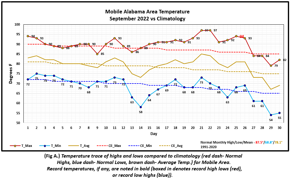
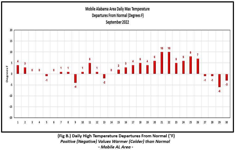
Mobile Alabama Area [Climate Normal Period 1991-2020, Climate Record Period 1872 to Present]- The average monthly high of 89.8° was 2.3° above normal. The average monthly low was 67.8° or 1.0° below normal. The average monthly temperature of 78.8° was 0.7° above normal. The highest temperature for the month was 97° on both the 21st and 22nd or 10° above the normal for these dates. A new record high, 94°, occurred on the afternoon of the 25th which tied the last occurrence set on this date back in 1961. The lowest temperature for the month was a cool 54° on the 29th, 11.0° below normal for this date. (Fig. A) shows a graphical representation of how the Mobile area temperatures compared to the seasonal normal daily highs and lows, which are shown by the colored dashed lines. Bar graphs reflecting the daily high/low temperature departures from normal are provided in the table below (Figs. B and C). Rain was minimal, with gauge catch at 1.22" (Fig. D), 4.08 " below the monthly normal. This also stands at 11th place for driest Septembers on record. The Mobile area has lost ground on annual rainfall made up by August excessive rains by sinking back into negative territory by a few inches. (Fig. E)
September top records for the month during the Period of Record for the Mobile Area:
Click on the Mobile Alabama area climate graphics below to expand:
|
|
|
|
|
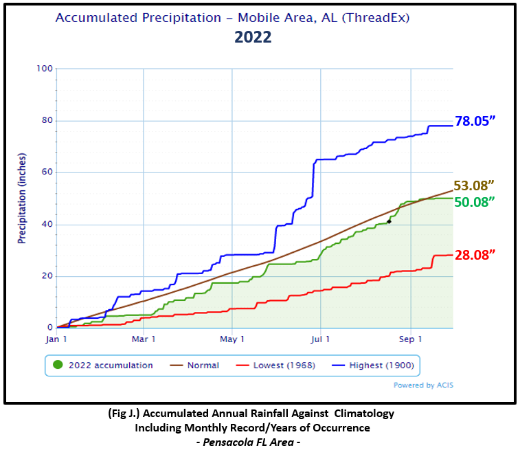
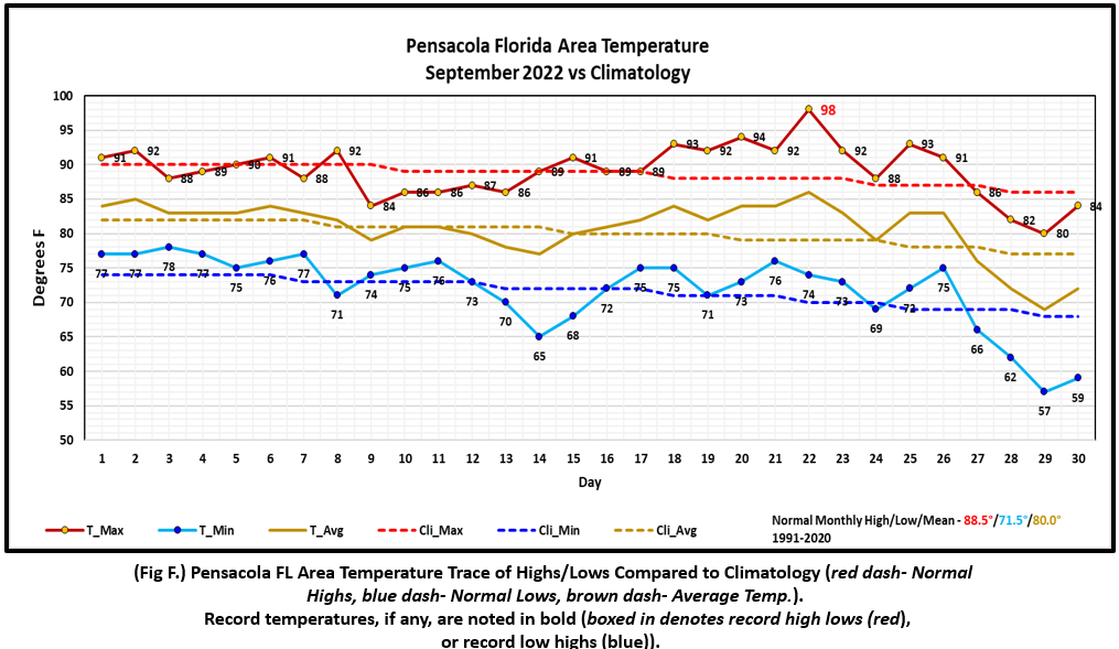
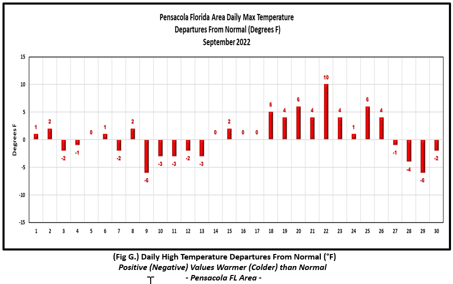
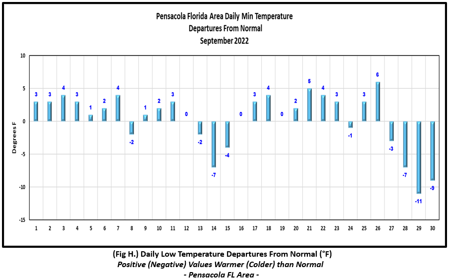
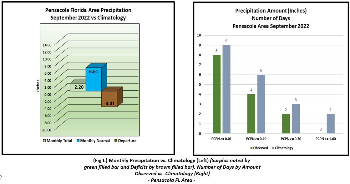
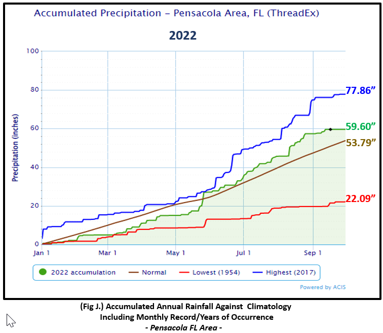
Pensacola Florida Area [Climate Normal Period 1991-2020, Climate Record Period 1879 to Present] - The average monthly high of 89.1° was 0.6° above normal. The average monthly low was 71.9° or 0.4° above normal. The average monthly temperature of 80.5° was 0.5° above normal. The highest temperature for the month, 98° on the 22nd was 10° above the normal daily high temperature and also set a new record high for this date. The previous record high was 96°, set in both 1990 and 1925. The lowest temperature for the month was a cool, 57° on the 29th, 11° below the normal daily low temperature for this date. (Fig. F) shows a graphical representation of how the Pensacola area temperatures compared to the seasonal normal daily highs and lows, which are shown by the colored dashed lines. (Figs. G and H) shows the daily high/low temperature departures from normal. A little more rain occurred in Pensacola with a gauge catch at 2.20" (Fig. I), or 4.41" below the monthly normal. Due to a dry September, the Pensacola area has lost some ground on it's annual surplus, which now stands at less than six inches above normal to date. (Fig. J).
September top records for the month during the Period of Record for the Pensacola Area:
Click on the Pensacola Florida area climate graphics below to expand:
|
|
|
|
|
Additional September 2022 Climatology and Topics
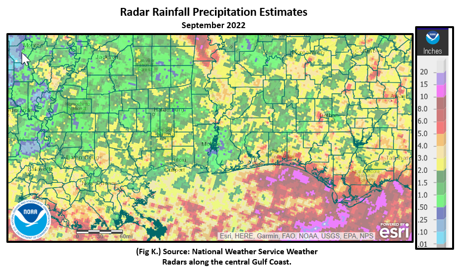
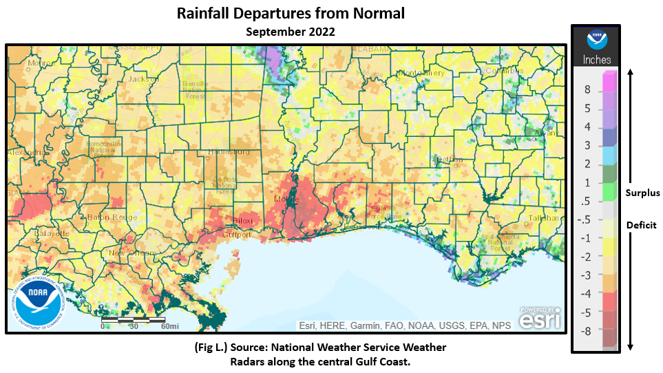
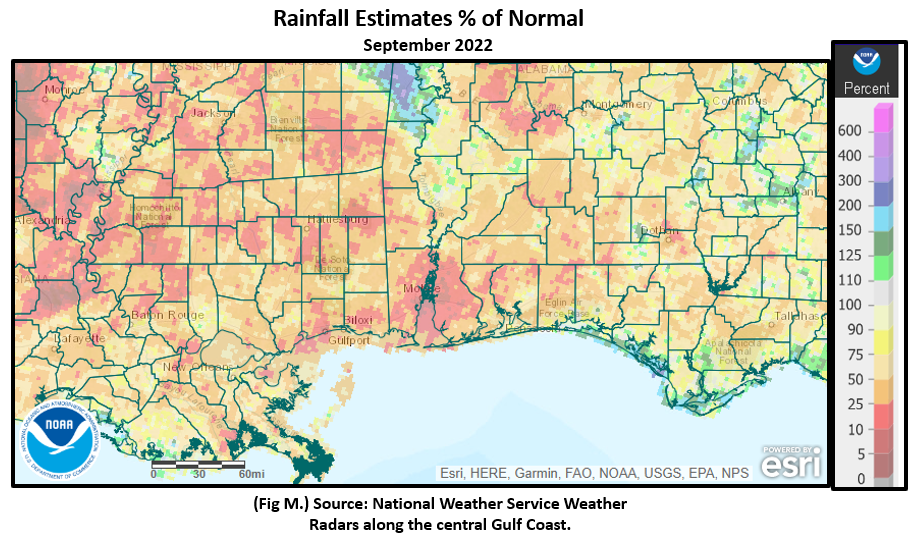
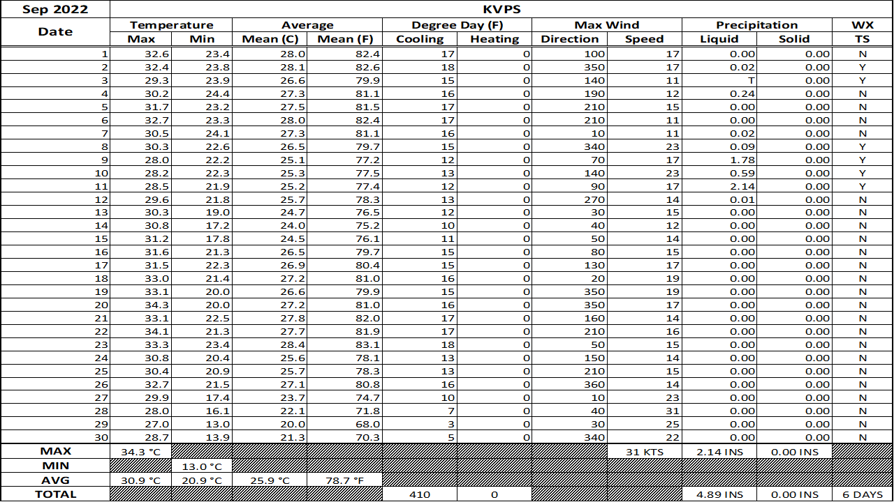
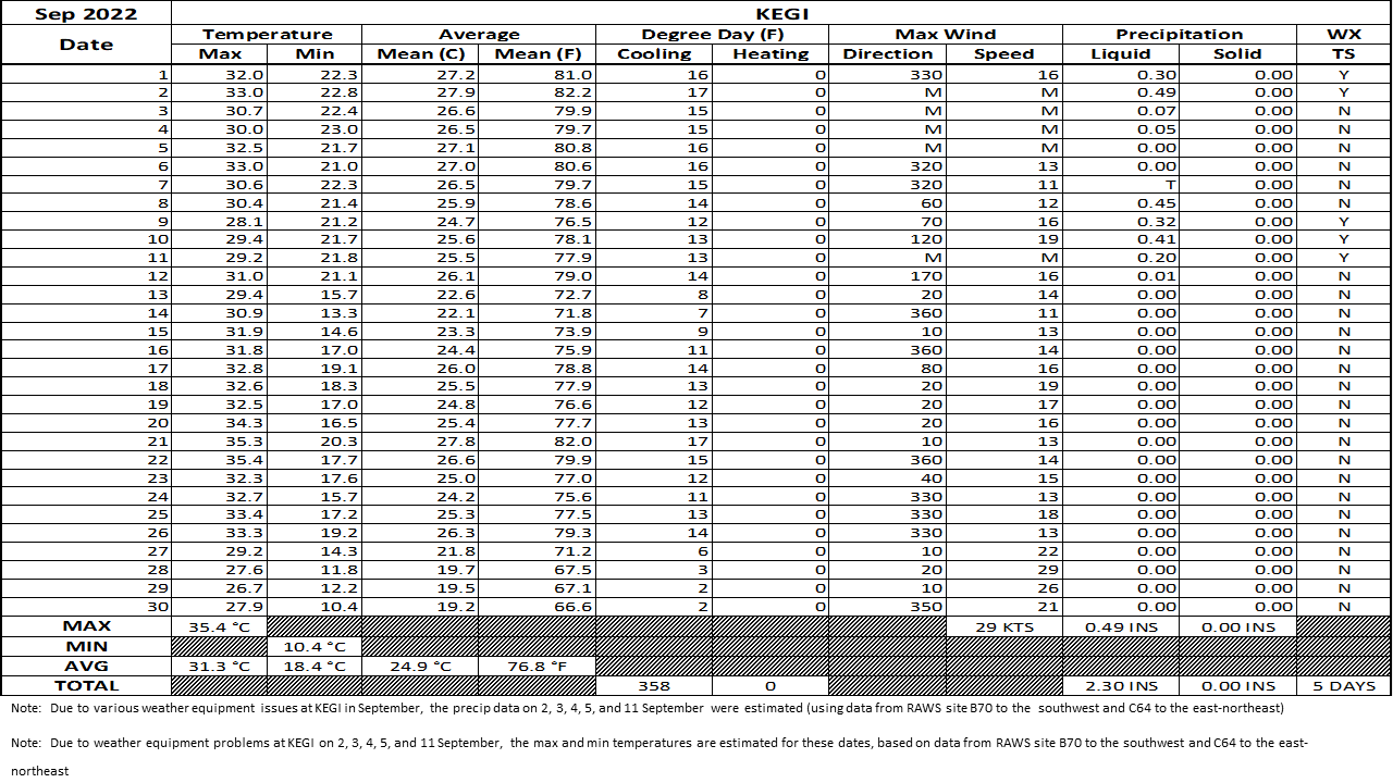
What a difference a month makes on precipitation with a yo-yo in occurrence from excessive, well above normal rains in August going into this month which was lacking. Much of the central Gulf coast saw monthly rainfall deficits by several inches and less than 50% of normal. The driest locations were interior southeast MS and the I-10 corridor of Mobile and Baldwin counties where 5 to 25% of monthly rain was observed. Fig. K shows the areal monthly rainfall total, Fig. L shows the areal rainfall departures from normal and Fig. M, the areal percent of normal rainfall. The September 2022 monthly summary for Eglin Air Force Base (AFB) - KVPS and Duke Field - KEGI has also been received and provided in the table below. The temperatures in the daily tables consists of numbers both in °F/°C. Data courtesy of Mr. David Biggar, Staff Meteorologist, 96th Weather Squadron. Provided by permission.
|
|
|

|
|
|
October 2022 Climatology, Seasonal Climatology and Outlooks:
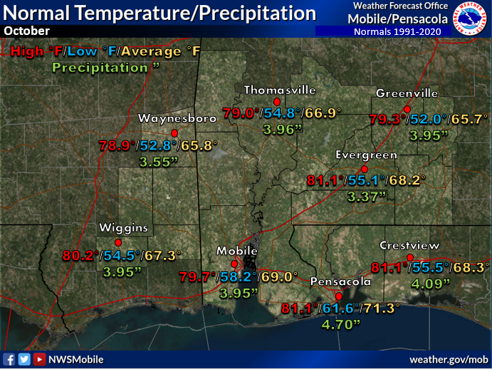
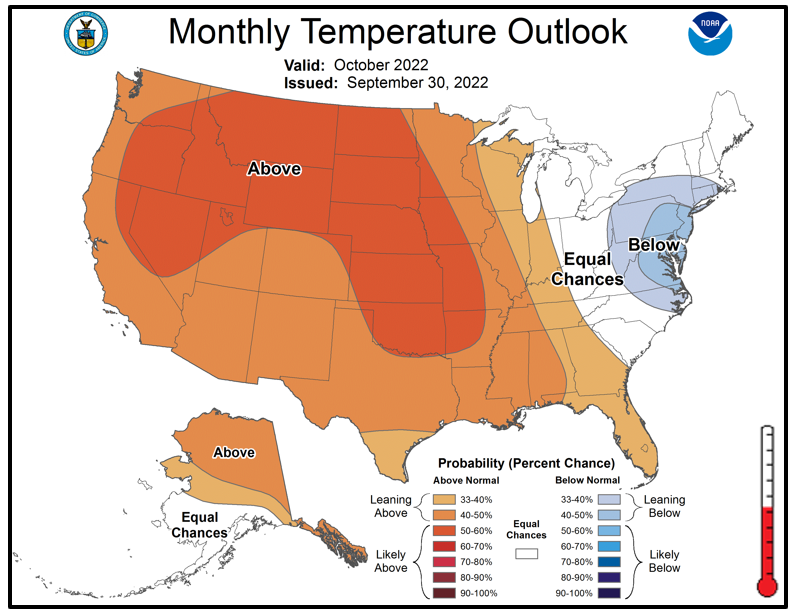
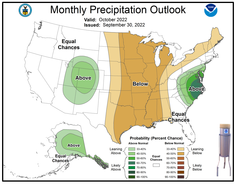
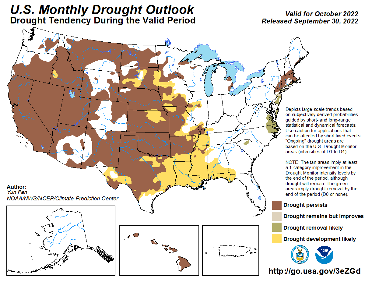
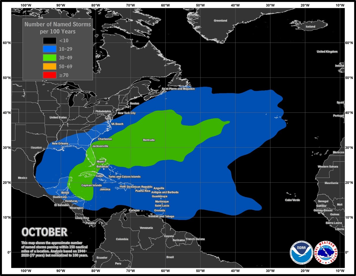
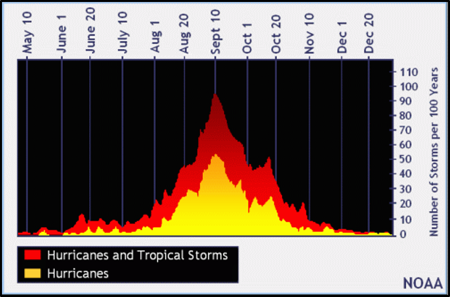
Looking ahead to October, the south central US is favored to see temperatures leaning above normal and precipitation leaning below normal. With September coming in well below normal on precipitation, October is outlooked to see drought development likely, expanding eastward from the Lower MS River Valley to across the coastal plain. As of now, the impacts look to be short term and focused on agriculture and grasslands. The National Weather Service in Mobile will be monitoring for any increase in drought intensity during the month of October which may require the issuance of drought information statements. To see the latest drought information click here. Although we have moved out of the climatological peak of hurricane season, take note that October does see a climatological spike in tropical cyclone occurrences while the points of origin primarily shift westward from the northwest Caribbean, Gulf and off the southeast US coast. NOAA's outlook can be seen here. It's highly encouraged to review your hurricane preparedness. Click on the Preparedness Tab on the NWS Mobile Tropical Webpage.
Click on the snap shots below to expand:
 October Normals October Normals |
|
Outlook |
|

|
|
|

|
Additional Climate Links:
The links below are intended to provide additional climate information, education and outlooks. The National Weather Service Mobile Alabama's Climate and Past Weather page provides climate data at your fingertips for many observation points in the local forecast area by accessing the NOWData tab as well as many other climate resources. The Climate Prediction Center Link provides short and longer range climatic outlooks and education about the larger scale global circulations that impact temperatures and weather. With the large agriculture and farming presence along the central Gulf coast, the Drought Monitor link provides updates on drought trends and impacts. Another very helpful resource is the Community Collaborative Rain Hail and Snow (CoCoRaHS) network, which is a large group of volunteers working together to measure and map precipitation (rain, hail and snow). The aim of CoCoRaHS is to provide the highest quality data for natural resource, education and research applications. You can be a part of the CoCoRaHS team by becoming a volunteer rainfall observer. To learn more click on the CoCoRaHS link below.
National Weather Service Mobile AL Climate and Past Weather
Climate Prediction Center (CPC)
CoCoRaHS Network Water Year Summaries


