October 2024 Climate Summaries
Mobile Alabama and Pensacola Florida Area
National Weather Service Mobile Alabama
November 1, 2024
October 2024 in Review - Similar to this time last year, the top story in the weather headlines is persistent drought. Although October is one of the driest times of the year for the central Gulf coast, the large rainfall deficits to well below the typical October normal has resulted in moderate to severe drought intensity maintaining a firm grip over the deep south.
Temperatures averaged above normal in all three metrics => highs, lows and means for both Mobile and Pensacola. The first third of the month saw temperatures mostly above normal. A cold front settled southward to out over the northern Gulf during the middle of the month with a reinforcing surge of cooler air bringing a substantial dip in temperatures to well below the means. The coolest period for Mobile, from a minimum temperature standpoint, was the 16th to the 22nd when numbers in the mid 40's to lower 50's during the period averaged 11.6° below normal. Thereafter, temperatures rebounded. The latter third of the month, high temperatures surged to Un-October like levels with daytime highs averaging 11.4° above normal from the 21st to the 31st. During this span, Mobile saw four consecutive days of record highs, three broken and one tied. Considering the warmth, Mobile's average high for October 2024 reached a new all-time warmest.
At Pensacola, the first third of the month also saw temperatures mostly above normal. The coolest period, was the 16th to the 18th when low temperatures dipped to a range of the upper 40's to lower 50's during the short period and averaged 11.3° below normal. Thereafter, temperatures rebounded with the warmest daily highs averaging 10.8° above normal observed from the 23rd to the 31st. Only one record high was reached and tied at Pensacola late in the month.
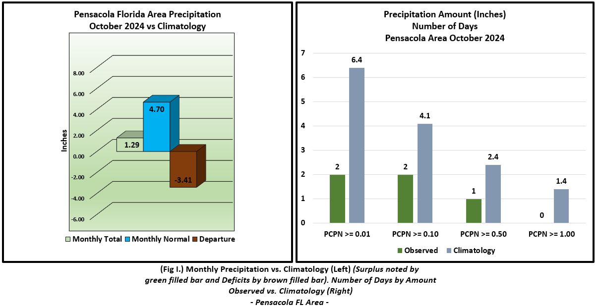
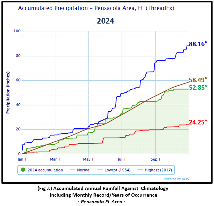
Rainfall for the month fell far short of typically normal October rainfall amounts by nearly 3.50" at Mobile and Pensacola. Year to date rainfall deficits are well over 4" and 5" below normal for the Mobile and Pensacola areas respectively at the close of October.
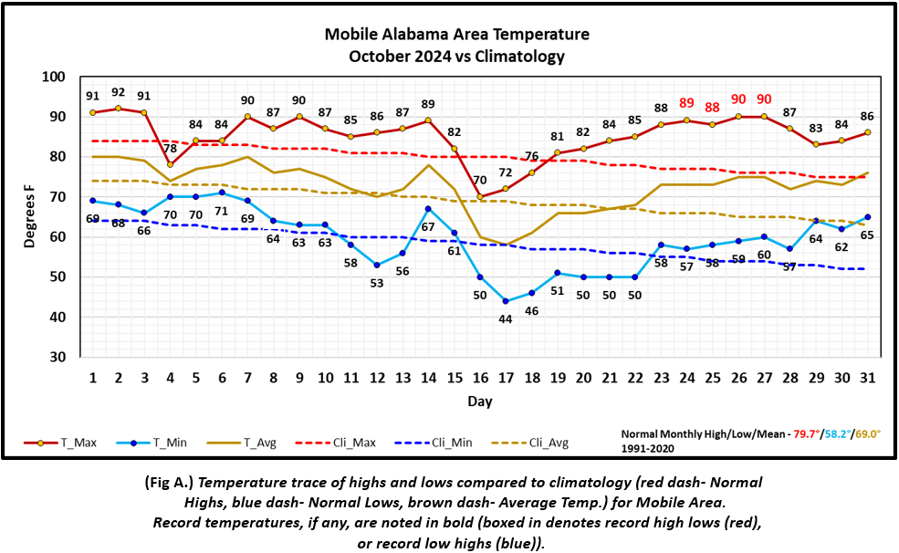
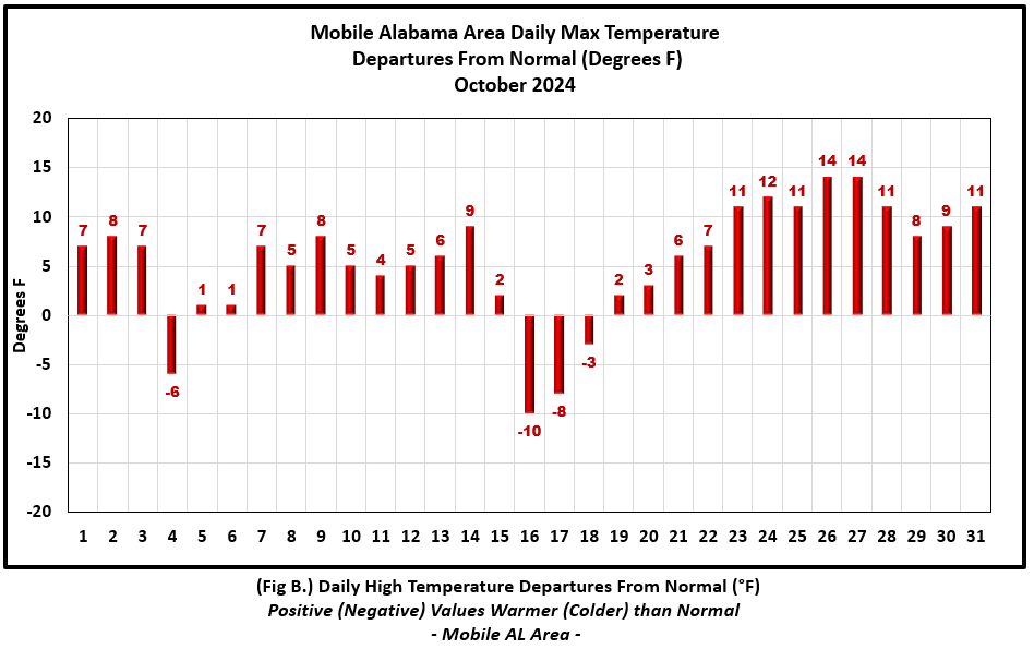
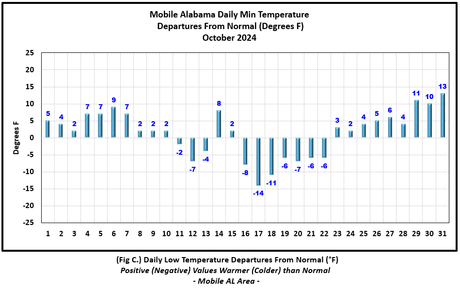
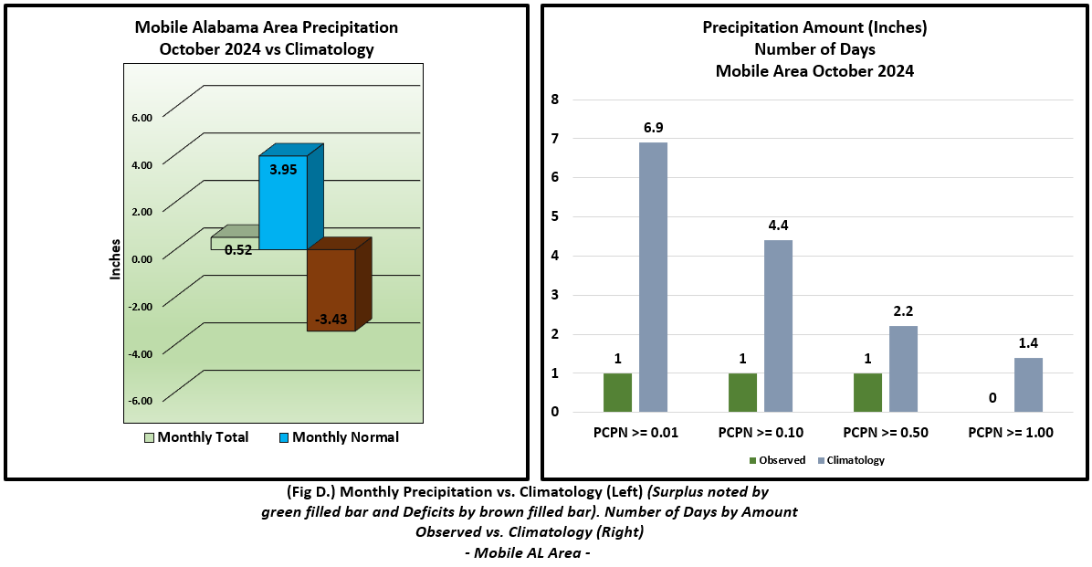
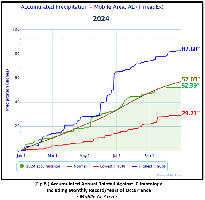
Mobile Alabama Area [Climate Normal Period 1991-2020, Climate Record Period 1872 to Present]- The average monthly high of 85.1° was 5.4° above normal and stands as the warmest Octobers on record for the average high. The average monthly low was 59.6° or 1.4° above normal. The average monthly temperature of 72.4° was 3.4° above normal. The highest temperature for the month was 92° on the 2nd or 8° above the normal for the date. The lowest temperature for the month was a chilly 44° on the morning of the 17th, or 14.0° below normal for this date. Four record highs were observed on the 24th, 25th, 26th and 27th. Please see the link to the Mobile Area October 2024 Temperature Records for details. There were seven days with high temperatures equaling 90°or higher, well above the typical October normal of only one day. (Fig. A) shows a graphical representation of how the Mobile area temperatures compared to the seasonal normal daily highs and lows, which are shown by the colored dashed lines. Bar graphs reflecting the daily high/low temperature departures from normal are provided in the table below (Figs. B and C). Very little rain for the month with only 0.52" (Fig. D) collected in the rain gauge and occurring on one day, the 4th. This was 3.43" below the monthly October normal. Annual rainfall remains in deficit to now 4.64" below normal for the Mobile area. (Fig. E)
October top records for the month during the Period of Record for the Mobile Area:
Click on the Mobile Alabama area climate graphics below to expand:
|
|
|
|
|
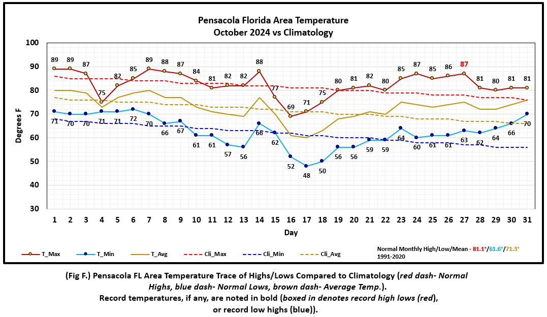
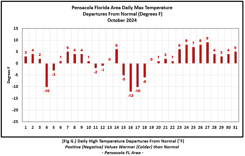
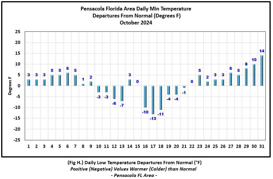
Pensacola Florida Area [Climate Normal Period 1991-2020, Climate Record Period 1879 to Present] - The average monthly high of 82.5° was 1.4° above normal. The average monthly low of 62.6° was 1.0° above normal. The average monthly temperature of 72.5° was 1.2° above normal. The highest temperature for the month was 89° and occurred on three days, the 1st, 2nd and the 7th, 3°, 4°, and 5° above normal on each respective date in order. The lowest temperature for the month was a cool 48° on the 17th, 13° below the normal daily low temperature for this date. Only one record high was reached and that occurred on the 27th when the thermometer reached 87° which matched the previous record occurrence on this date back in 2010. (Fig. F) shows a graphical representation of how the Pensacola area temperatures compared to the seasonal normal daily highs and lows, which are shown by the colored dashed lines. (Figs. G and H) shows the daily high/low temperature departures from normal. Monthly rain was greatly lacking with a gauge catch totaling only 1.29" (Fig. I), or 3.41" below the monthly normal. The deficit in annual rainfall at Pensacola is now 5.64" below normal. (Fig. J).
October top records for the month during the Period of Record for the Pensacola Area:
Click on the Pensacola Florida area climate graphics below to expand:
|
|
|
|
|
Additional October 2024 Climatology and Topics
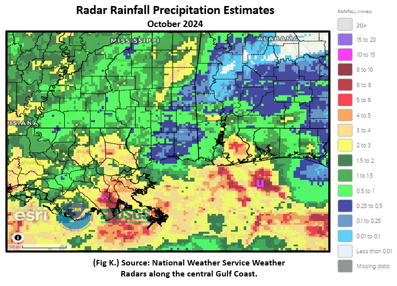
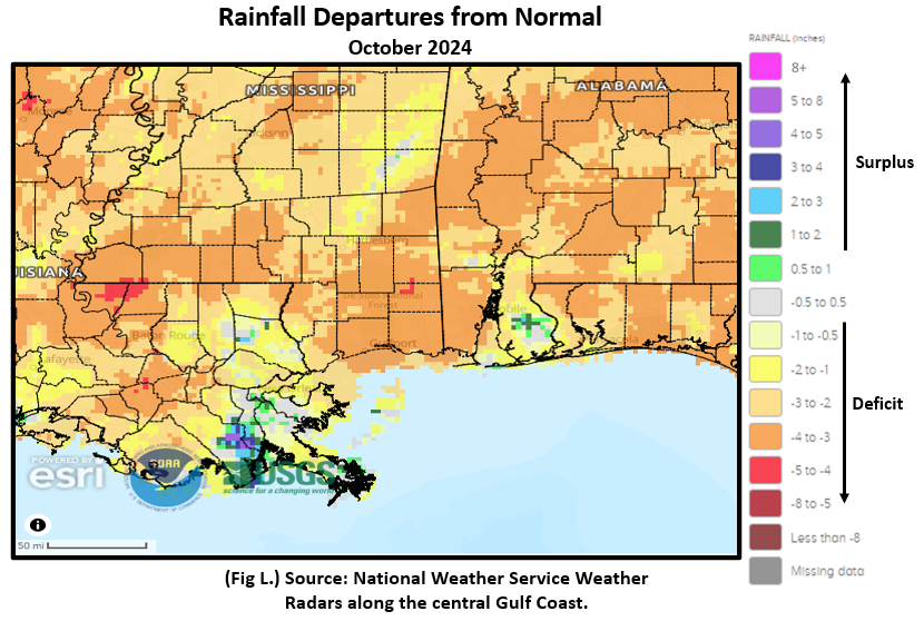
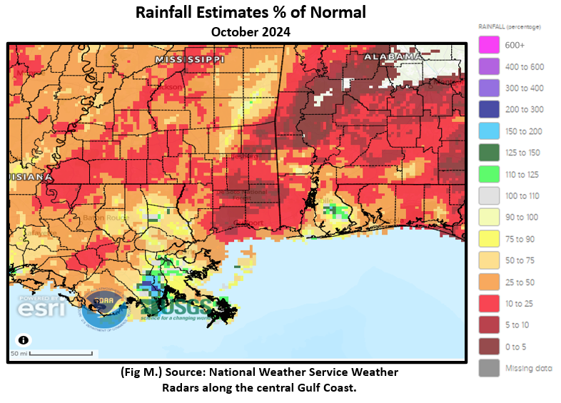
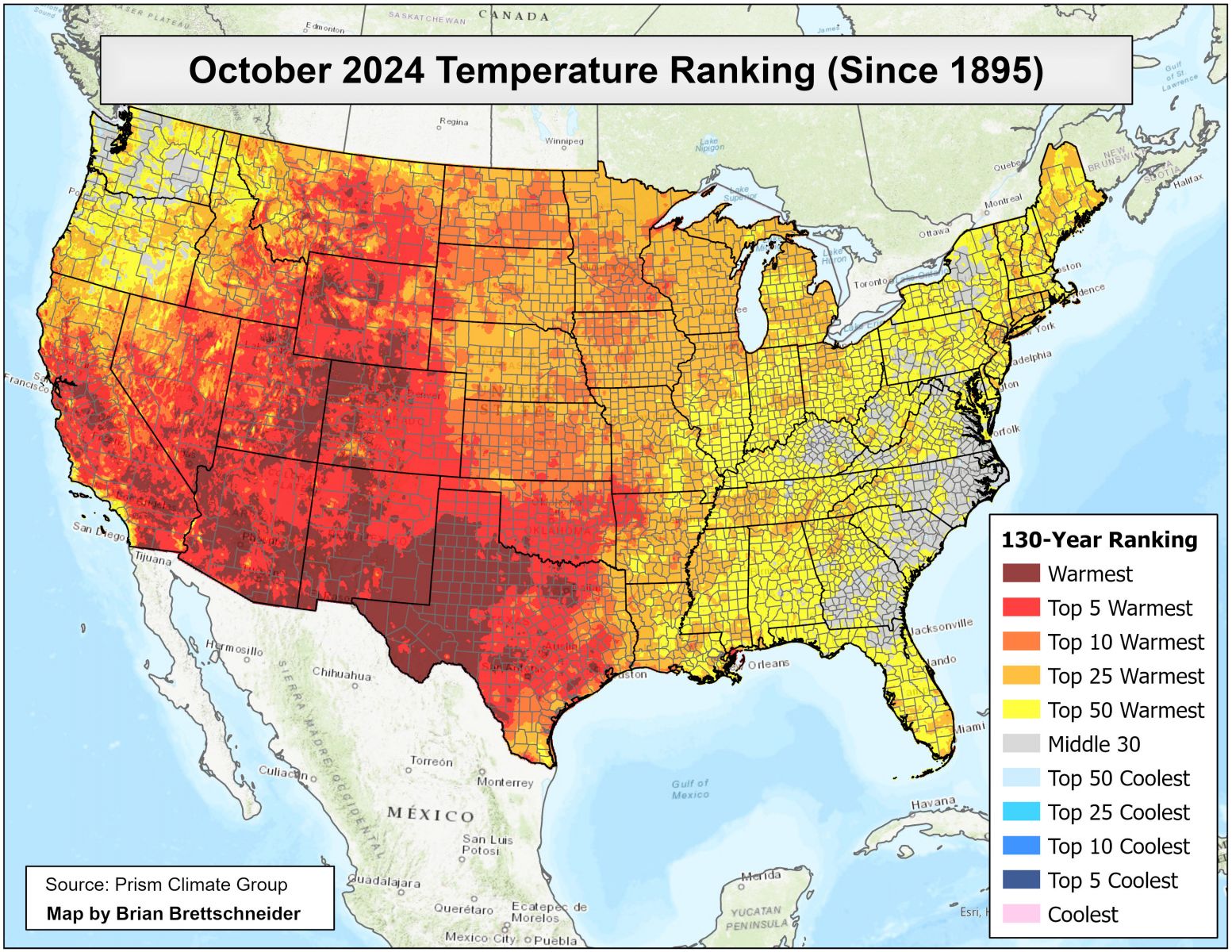
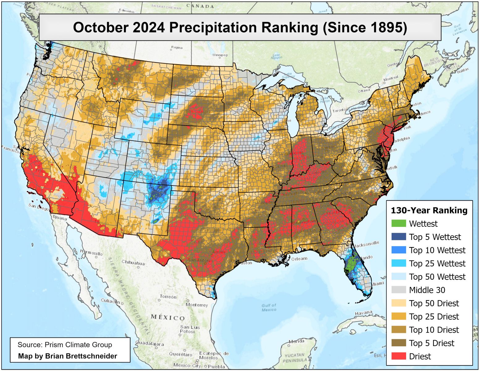
Rainfall was in very short supply with a majority of the coastal plain receiving 10 to 25% of normal monthly rain or less, to less than 10% of normal over a significant coverage of the local area as well, mostly interior. There was only a small area of south central Baldwin county that saw appreciable rains. Fig. K shows the areal monthly rainfall total, Fig. L shows the areal rainfall departures from normal and Fig. M, the areal percent of normal rainfall. (Figs. N and O) are national quick glance maps of October temperature and precipitation respectively and how the October 2024 warmth and dryness compares to the period of record dating back to 1895 from (unofficial) Prism climate data, courtesy of Brian Brettschneider, NOAA.
The latest October 2024 Monthly Climate Summary for Eglin Air Force Base (KVPS) and Duke Field (KEGI) has been provided courtesy of Mr. David Biggar, Staff Meteorologist, 96th Weather Squadron. Provided by permission.
|
|
|
|
|
November 2024 Climatology, Seasonal Climatology and Outlooks:
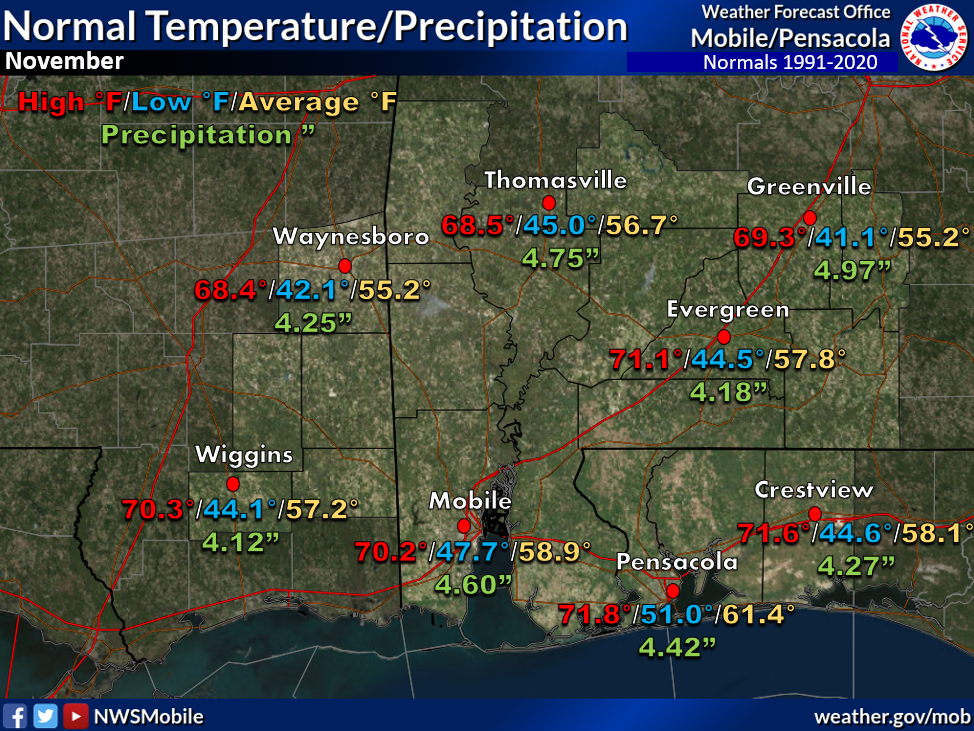
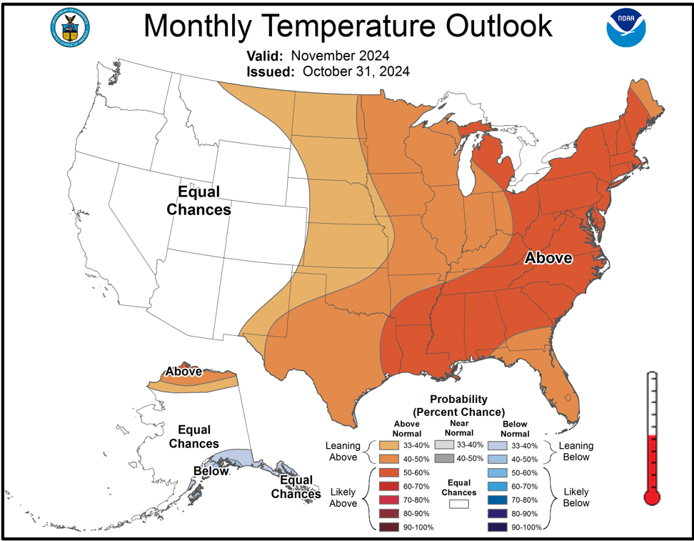
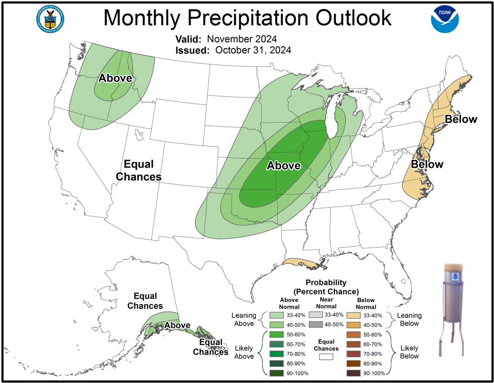
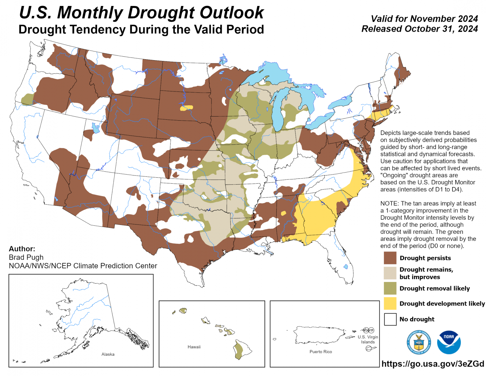
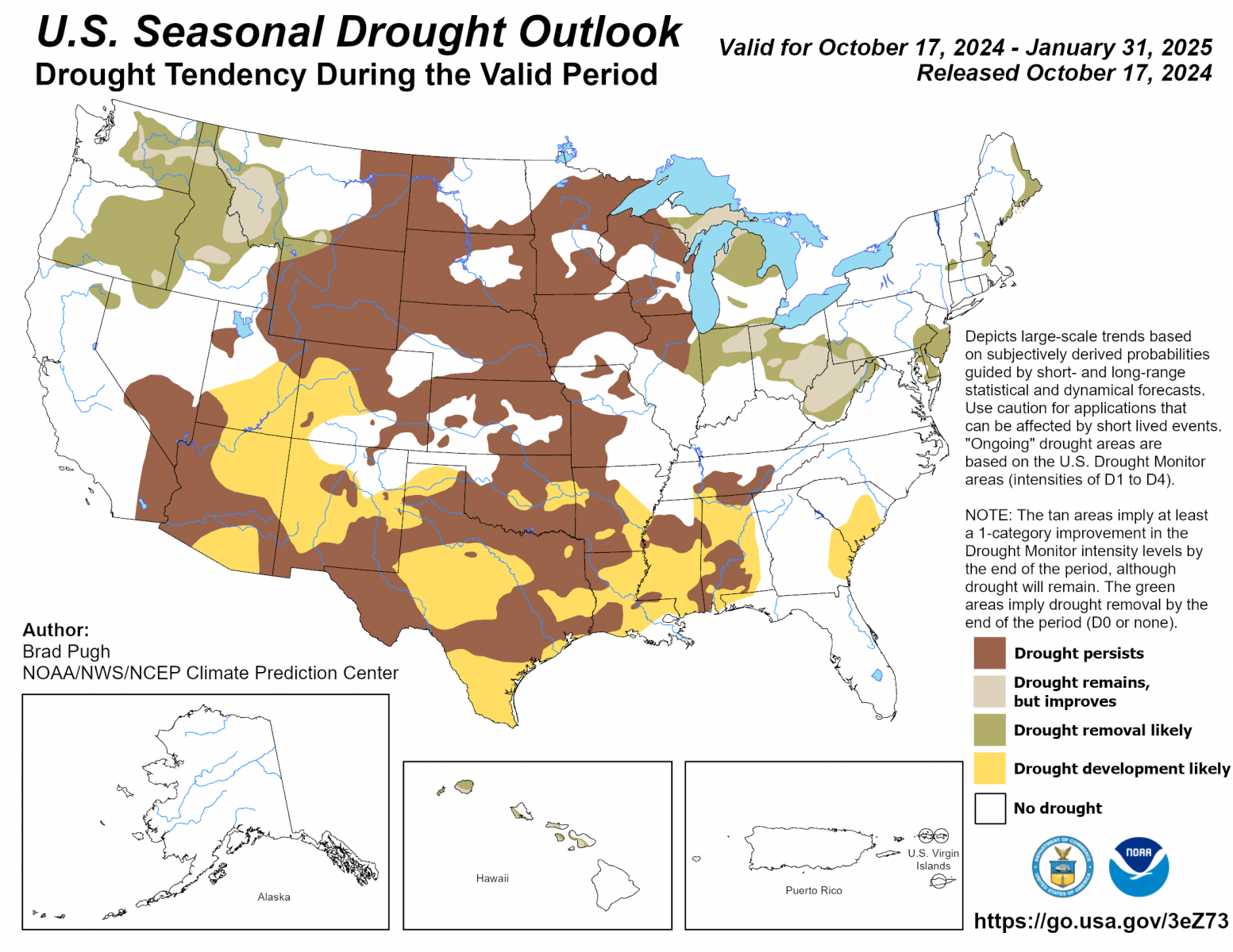
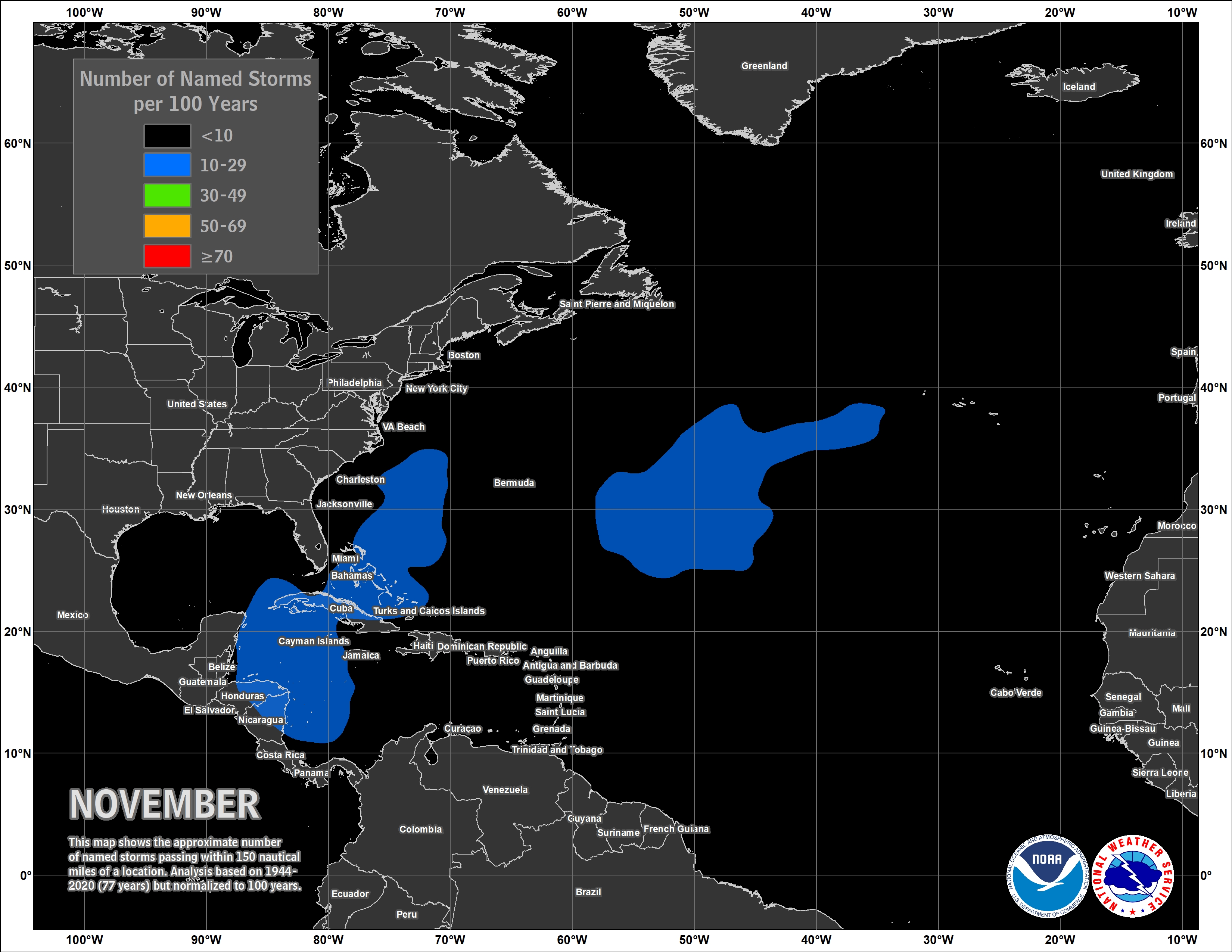
Looking ahead to November, the deep south is favored to see temperatures likely above normal while there is equal chances of seeing above or below normal precipitation. Unfortunately, the longer term outlook regarding drought does not appear too good with drought forecast to persist for a large portion of the local area. The greater local drought impacts continues to focus on wildfire and agriculture. On October 30th, the Alabama Forestry Commission issued a Fire Danger Advisory for ALL Alabama counties. Dead pines in area forests which have been devastated by southern pine beetles over the summer are adding to the increased wildfire potential, as well as challenges to containment efforts. Over the month of October, 246 wildfires in AL have burned nearly 3000 acres. In the driest of areas, poor to very poor crop condition, widespread crop disease, insect damage and stress on livestock is common. Please visit the National Integrated Drought Information System (NIDIS) for the latest updates on local and regional drought statements, impacts and outlooks. We are now moving into the last official month of the Atlantic Basin hurricane season with the points of origin for late season storms focused over the northwest Caribbean to off the southeast US coast. NOAA issued its Winter Weather Outlook October 17th.
Click on the snap shots below to expand:
 November Normals November Normals |
|
Outlook |
|
|
|
Additional Climate Links:
The National Weather Service Mobile Alabama's Climate and Past Weather page provides climate data at your fingertips for many observation points in the local forecast area by accessing the NOWData tab as well as many other climate resources. The Climate Prediction Center Link provides short and longer range climatic outlooks and education about the larger scale global circulations that impact temperatures and weather. With the large agriculture and farming presence along the central Gulf coast, the Drought Monitor link provides updates on drought trends and impacts. Another very helpful resource is the Community Collaborative Rain Hail and Snow (CoCoRaHS) network, which is a large group of volunteers working together to measure and map precipitation (rain, hail and snow). The aim of CoCoRaHS is to provide the highest quality data for natural resource, education and research applications. You can be a part of the CoCoRaHS team by becoming a volunteer rainfall observer.