October 2022 Climate Summaries
Mobile Alabama and Pensacola Florida Area
National Weather Service Mobile Alabama
November 1, 2022
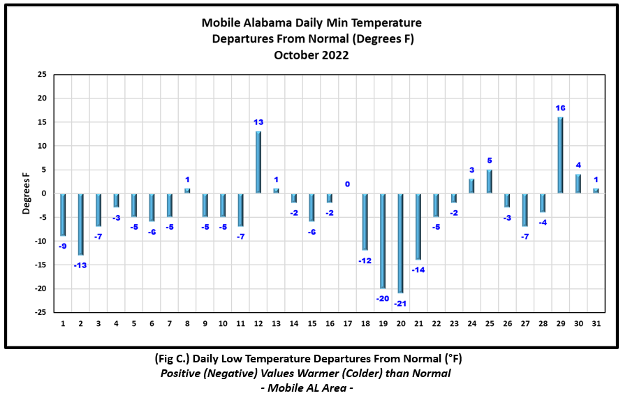
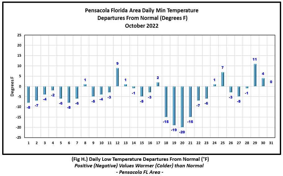
October 2022 in Review - Average high temperatures for the month were fairly close to normal with average lows showing more of a departure, coming in just shy of 4.0° below normal at both Mobile and Pensacola. Assisting in the below normal monthly lows was the passage of Fall's first substantial cold front which surged through the central Gulf coast on Monday October 17th. Following the passage of the front, overnight lows plunged on the 18th through the 21st where numbers averaged 16.7° and 17.2° below normal at Mobile and Pensacola respectively. During this span, a new record low was broken at Mobile on the morning of the 19th at a chilly 37°.
Precipitation, or the lack thereof, continues to make weather headlines over the central Gulf coast where the local area has closed out the month of October finding moderate to severe drought conditions taking a foothold. The most notable and beneficial rains did not come until the latter few days of October, but even with that, the monthly totals were shy of normal. In fact, Pensacola saw monthly deficits by a little over 3.5" below normal.
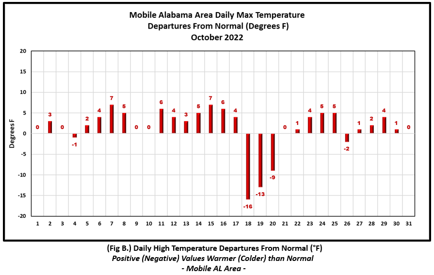
Mobile Alabama Area [Climate Normal Period 1991-2020, Climate Record Period 1872 to Present]- The average monthly high of 80.9° was 1.2° above normal. The average monthly low was 54.4° or 3.8° below normal. The average monthly temperature of 67.7° was 1.3° below normal. The highest temperature for the month was 90° on the 7th or 7° above the normal for the date. Mobile saw a record high low temperature reached on the 12th, 73° which tied the previous occurrence on this date set back in 1969. The lowest temperature for the month was a crisp 36° on the morning of the 20th, or a phenomenal 21.0° below normal for this date. The day prior, a new record low was reached on the morning of the 19th, 37° which broke the previous record of 38° set on this date in 1989. (Fig. A) shows a graphical representation of how the Mobile area temperatures compared to the seasonal normal daily highs and lows, which are shown by the colored dashed lines. Bar graphs reflecting the daily high/low temperature departures from normal are provided in the table below (Figs. B and C). Rain was minimal yet again for the month and although a late month storm system brought a beneficial rain to the Mobile area, the monthly total gauge catch at 3.21" (Fig. D) was shy of normal by 0.74". Annual rainfall remains in deficit by shy of four inches. (Fig. E)
October top records for the month during the Period of Record for the Mobile Area:
Click on the Mobile Alabama area climate graphics below to expand:

|
|
|

|

|
Pensacola Florida Area [Climate Normal Period 1991-2020, Climate Record Period 1879 to Present] - The average monthly high of 80.4° was 0.7° below normal. The average monthly low was 57.9° or 3.7° below normal. The average monthly temperature of 69.2° was 2.1° below normal. The highest temperature for the month was 89° on both the 2nd and the 7th, 4 and 5° above the normal daily high temperature for these dates respectively. The lowest temperature for the month was a chilly, 40° on the 20th, or a substantial 20° below the normal daily low temperature for this date. Considering the strength of the arctic air during the middle of the month, surprisingly, no record highs or lows were reached at Pensacola. (Fig. F) shows a graphical representation of how the Pensacola area temperatures compared to the seasonal normal daily highs and lows, which are shown by the colored dashed lines. (Figs. G and H) shows the daily high/low temperature departures from normal. Monthly rain was lacking with a gauge catch totaling only 1.15" (Fig. I), or 3.55" below the monthly normal. Due to an extension of the prolonged dry spell carrying over from September into October, the Pensacola area's annual surplus continues to shrink, which now stands at a little over two inches above normal to date. (Fig. J).
October top records for the month during the Period of Record for the Pensacola Area:
Click on the Pensacola Florida area climate graphics below to expand:

|

|
|

|

|
Additional October 2022 Climatology and Topics
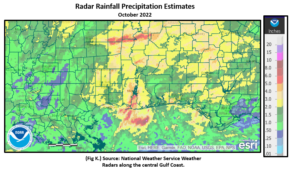
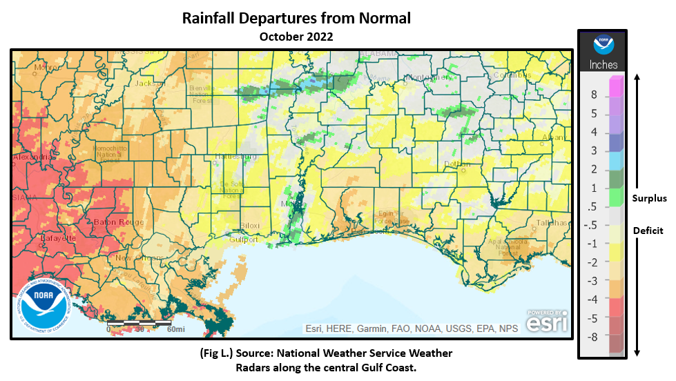
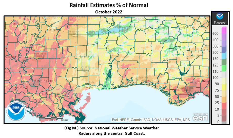
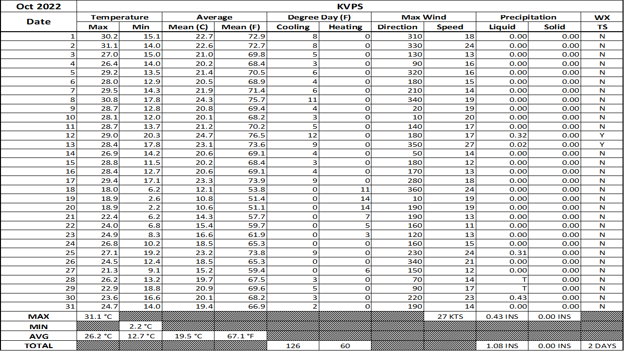
A substantial lack in precipitation over a two month span from September to October across the coastal plain is causing an uptick in drought intensity. Outside of a few pockets over the Mobile, Tensaw, Tombigbee and Alabama River Delta's, much of the local area has seen deficits in October rain ranging mostly 25 to 75% off the normal pace. Fig. K shows the areal monthly rainfall total, Fig. L shows the areal rainfall departures from normal and Fig. M, the areal percent of normal rainfall. The October 2022 monthly summary for Eglin Air Force Base (AFB) - KVPS and Duke Field - KEGI has also been received and provided in the table below. The temperatures in the daily tables consists of numbers both in °F/°C. Data courtesy of Mr. David Biggar, Staff Meteorologist, 96th Weather Squadron. Provided by permission.
|
|
|

|
|

|
November 2022 Climatology, Seasonal Climatology and Outlooks:
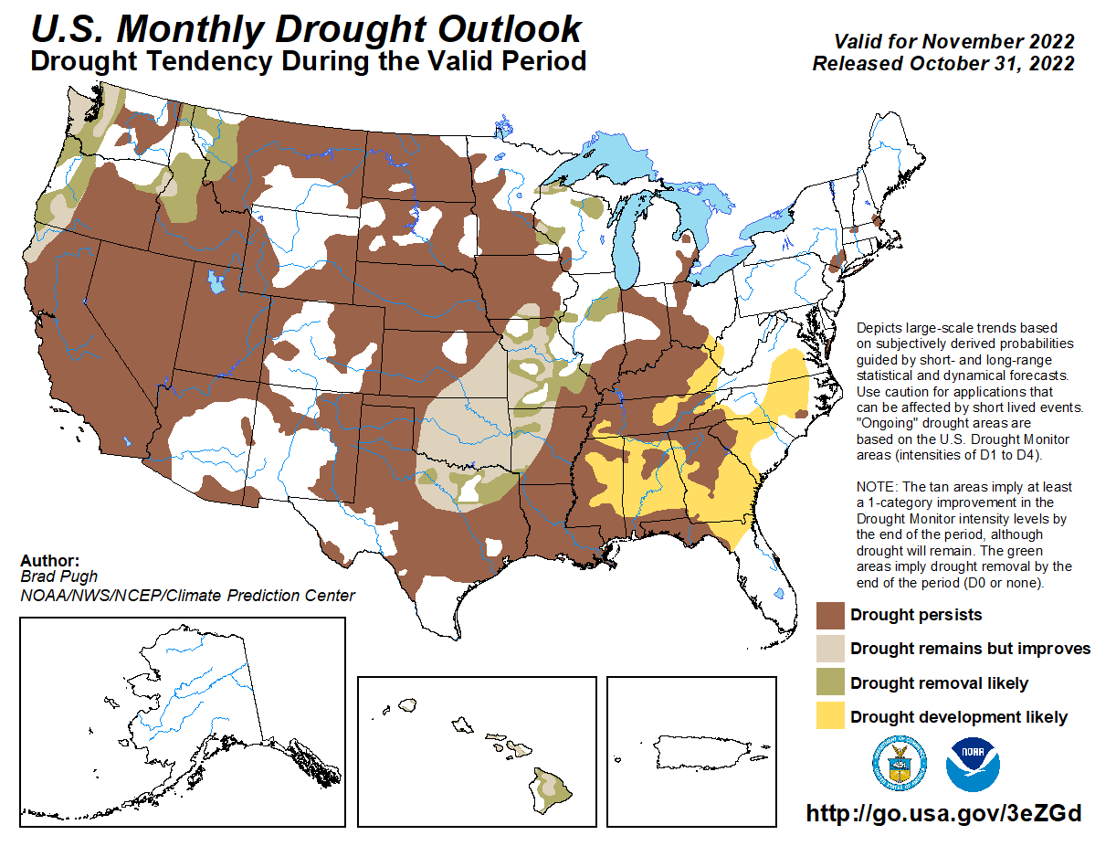
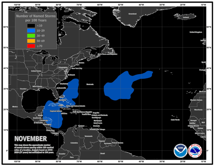
Looking ahead to November, the eastern half of the continental US is favored to see temperatures leaning above normal. Precipitation, primarily east of the Mississippi River Valley, appears to be leaning below normal. This is not good for those hoping to see an easing of drought conditions over the coastal plain, which at the close of October showed moderate to severe drought impacting much of the NWS Mobile/Pensacola county warning area. Severe drought was more focused along the coastal counties. As of now, the impacts continue to look to remain short term and focused on agriculture and grasslands. Although November typically shows a substantial lowering in tropical cyclone frequency, Gulf coast residents cannot let their guard down. Primary points of origin in November are focused from the northwest Caribbean across the Bahamas and up across the Gulf Stream.
Click on the snap shots below to expand:
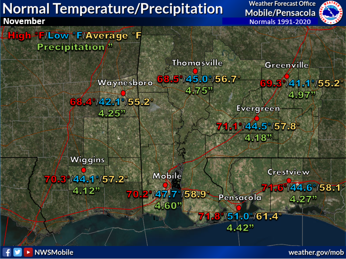 November Normals November Normals |

|

Outlook |
|

|
|

|

|
Additional Climate Links:
The links below are intended to provide additional climate information, education and outlooks. The National Weather Service Mobile Alabama's Climate and Past Weather page provides climate data at your fingertips for many observation points in the local forecast area by accessing the NOWData tab as well as many other climate resources. The Climate Prediction Center Link provides short and longer range climatic outlooks and education about the larger scale global circulations that impact temperatures and weather. With the large agriculture and farming presence along the central Gulf coast, the Drought Monitor link provides updates on drought trends and impacts. Another very helpful resource is the Community Collaborative Rain Hail and Snow (CoCoRaHS) network, which is a large group of volunteers working together to measure and map precipitation (rain, hail and snow). The aim of CoCoRaHS is to provide the highest quality data for natural resource, education and research applications. You can be a part of the CoCoRaHS team by becoming a volunteer rainfall observer. To learn more click on the CoCoRaHS link below.
National Weather Service Mobile AL Climate and Past Weather
Climate Prediction Center (CPC)
CoCoRaHS Network Water Year Summaries


