October 2019 Climate Summaries
Mobile Alabama and Pensacola Florida Area
National Weather Service Mobile Alabama
November 3, 2019
October 2019 in Review - Record heat continued from September into the first few days of the beginning of October along the central Gulf coast. In fact, to open up the month, there were two straight days where the same daily high temperature also met the all-time warmest days in the period of record for the Mobile area and on one day in the Pensacola area. Daily highs and lows were well above seasonal normals for both the Mobile and Pensacola areas for the first two weeks of the month. Highs then hovered closer to seasonal averages by the latter end of the month. Overnight lows however, swung more wildly about the seasonal means to end the month. After moving out of a very dry month of September, the opposite was true for October with Mobile seeing the rain gauge filling up to several inches above normal. Some areas that received excessive rainfall saw much more improvement in drought conditions, including the Mobile area.
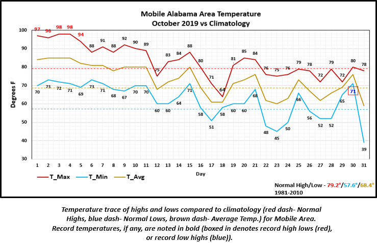
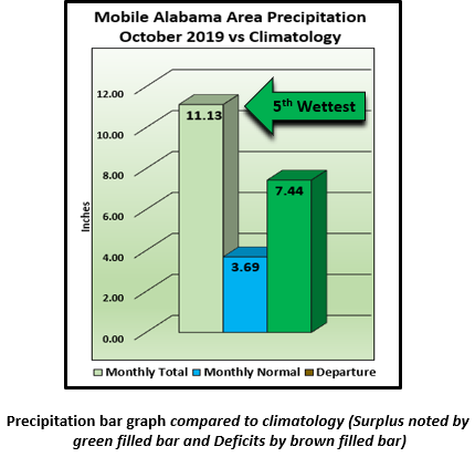
Mobile Alabama Area - The average monthly high of 83.3° was 4.1° above normal and now stands as the 8th warmest Octobers on record. The average monthly low of 62.2° was 4.6° above normal. The average monthly temperature of 72.7° was 4.3° above normal. (Fig. A) is a table listing all the record temperatures, tied or broken and previous record/year of occurrence. Six record temperatures were observed. On the 3rd and 4th of the month, the occurrence of 98° set a new all time monthly high for the period record dating back to 1872. (Fig. B) shows how the Mobile area temperatures compared to the seasonal normal monthly highs and lows, which are shown by the colored dashed lines. Total rainfall for October (Fig. C) measured an anomalously high 11.13" or 7.44" above normal, which is 5th wettest on record. Mobile saw two days of record one day rainfall this month, on the 21st measuring 1.05" and on the 25th seeing 2.87". After running an annual rainfall deficit for quite some time now, excessive rain from October (Fig. D) created an annual surplus at just over an inch and a half above seasonal normal.
Click on the Mobile Alabama area climate graphics below to expand:

|
|
|

|
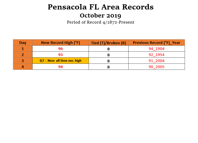
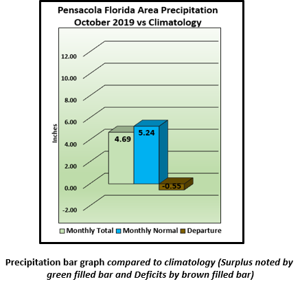
Pensacola Florida Area - The average monthly high of 83.8° was 4.9° above normal and stands as the 3rd warmest Octobers on record. The average monthly low of 65.7° was 5.4° above normal. The average monthly temperature of 74.7° was 5.1° above normal and stands as the 7th warmest on record. (Fig. E) is a table listing all the record temperatures, tied or broken and previous record/year of occurrence. Four record temperatures were observed. On the 3rd of the month, the occurrence of 97° set a new all time monthly high for the period of record dating back to 1879.(Fig. F) shows how the Pensacola area temperatures compared to the seasonal normal monthly highs and lows, which are shown by the colored dashed lines. October's accumulated rainfall (Fig. G) was lower than the Mobile area by more than a half. Annual rainfall (Fig. H) indicates that deficits are just shy of a foot from where we should be this time of year. Moderate to severe drought conditions remain.
Click on the Pensacola Florida area climate graphics below to expand:
|

|
|

|
November Climatology and Outlooks:
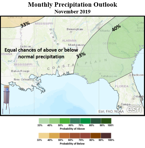
There are equal chances of seeing above or below normal temperatures for November over the coastal plain while a 33% probability of above normal rain is favored over the southeast, extending westward into areas that continue to deal with moderate to severe drought generally east of a line from Thomasville to Orange Beach Alabama. The latest monthly outlook for drought mentions some improvement or perhaps removal over these areas.
Click on the snap shots below to expand:

|

Outlook |
Outlook |
|
Climate Prediction Center's Interactive Long Range Outlooks
Additional Climate Links:
The links below are intended to provide additional climate information, education and outlooks. The National Weather Service Mobile Alabama's Climate and Past Weatherpage provides climate data at your fingertips for many observation points in the local forecast area by accessing the NOWData tab as well as many other climate resources. The Climate Prediction Center Link provides short and longer range climatic outlooks and education about the larger scale global circulations that impact temperatures and weather. With the large agriculture and farming presence along the central Gulf coast, the Drought Monitor link provides updates on drought trends and impacts. Another very helpful resource is the Community Collaborative Rain Hail and Snow (CoCoRaHS) network, which is a large group of volunteers working together to measure and map precipitation (rain, hail and snow). The aim of CoCoRaHS is to provide the highest quality data for natural resource, education and research applications. You can be a part of the CoCoRaHS team by becoming a volunteer rainfall observer. To learn more click on the CoCoRaHS link below.
National Weather Service Mobile AL Climate and Past Weather
Climate Prediction Center (CPC)
CoCoRaHS Network Water Year Summaries


