November 2022 Climate Summaries
Mobile Alabama and Pensacola Florida Area
National Weather Service Mobile Alabama
December 5, 2022
November 2022 in Review - The first and latter third of the month was markedly well above normal at Mobile and Pensacola. Two record highs were reached at Mobile and Pensacola on the 7th and 8th. In fact, summer-like highs on the 8th in both Mobile and Pensacola tied the warmest daily temperature on record for the month. More specifics on this will be provided in the areal discussions soon to follow. The middle of the month turned sharply cooler than normal following the passage of a strong cold front on Saturday November 12th. Highs plunged to an average of 12.3° degrees lower than climatology at Mobile and 9.9° degrees lower than climatology at Pensacola between the 13th and 20th. Overnight lows averaged near 8° degrees lower than climatology at both Mobile and Pensacola between the 12th and 21st.
As far as rainfall is concerned, there are two stories from November. The Mobile area has seen a surplus in monthly rain against the normals while Pensacola recorded a deficit. Weather systems that tracked east over the deep south lost their punch as they crossed the I-65 corridor where rain coverage lowered with each event. Monthly rainfall at Mobile has eased drought somewhat but the area continues to be abnormally dry. On the other hand, Pensacola continues to deal with severe drought conditions.
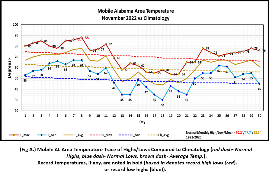
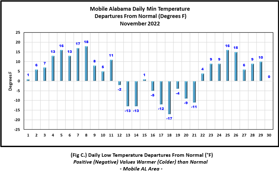
Mobile Alabama Area [Climate Normal Period 1991-2020, Climate Record Period 1872 to Present]- Despite, the well below normal temperatures the middle of the month, monthly temperatures were above normal. he average monthly high of 72.0° was 1.8° above normal. The average monthly low was 51.4° or 3.7° above normal. The average monthly temperature of 61.7° was 2.8° above normal. The highest temperature for the month, a summer-like 88°, occurred on the 8th and 16° above the normal for the date; This also smashed the previous record high for this date of 83° set in 1973, 1986, and 2005. 88° on the 8th also tied the record all-time highest daily temperature for the month with the last occurrence coming during a warm spell on November 4th, 2016. The day prior, 86° on the 7th broke the previous record of 85° set way back in 1935. The lowest temperature for the month plunged to a crisp 30° on the morning of the 18th, 17° below normal for this date. No record low temperatures were reached. (Fig. A) shows a graphical representation of how the Mobile area temperatures compared to the seasonal normal daily highs and lows, which are shown by the colored dashed lines. Bar graphs reflecting the daily high/low temperature departures from normal are provided in the table below (Figs. B and C). The rain gauge collected 6.28" (Fig. D), or 1.68" above the monthly normal. The Mobile area continues to see an annual rainfall deficit, now a little over two inches. Annual total of 59.57" or 2.06" below normal to date. (Fig. E).
November Top Records for the Month During the Period of Record for the Mobile Area:
Click on the Mobile Alabama area climate graphics below to expand:
|

|
|

|

|
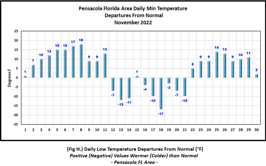
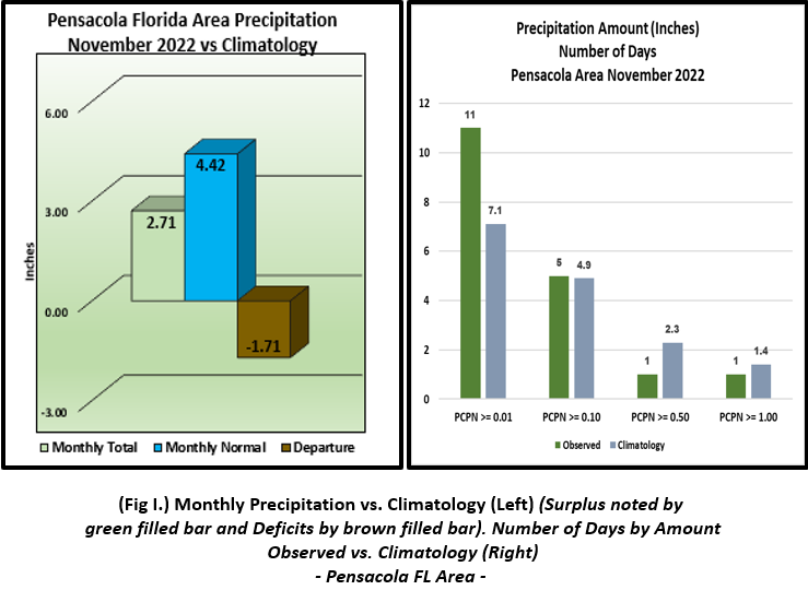
Pensacola Florida Area [Climate Normal Period 1991-2020, Climate Record Period 1879 to Present] - Despite, the well below normal temperatures the middle of the month, monthly temperatures were also above normal. The average monthly high of 73.8° was 2.0° above normal. The average monthly low was 55.3° or 4.3° above normal. The average monthly temperature of 64.6° was 3.2° above normal. The highest temperature for the month, a summer-like 89°, occurred on the 8th and 15° above the normal for the date; this also smashed the previous record high for this date of 85° set in 2020. 89° on the 8th also tied the record all-time highest daily temperature for the month with the last occurrence coming during a warm spell on November 4th, 2016. The day prior, 85° on the 7th broke the previous record of 83° set on this date back in 1975. The lowest temperature for the month plunged to a crisp 33° on the morning of the 18th, 17° below normal for this date. No record low temperatures were reached.(Fig. F) shows a graphical representation of how the Pensacola area temperatures compared to the seasonal normal daily highs and lows, which are shown by the colored dashed lines. (Figs. G and H) shows the daily high/low temperature departures from normal. The rain gauge collected 2.71" (Fig. D), or 1.71" below the monthly normal. Unlike Mobile, the Pensacola area sees an annual rainfall very close to normal. Despite annual totals of 63.46" being 0.55" above normal to date, drought conditions remain severe due to limited monthly rains over the past few months. (Fig. J).
November Top Records for the Month During the Period of Record for the Pensacola Area:
Click on the Pensacola Florida area climate graphics below to expand:

|

|
|
|

|
Additional November 2022 Climatology and Topics
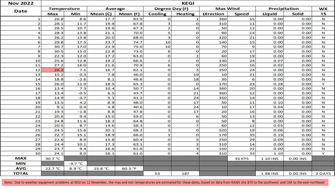
The bulk of the rain through the month of November occurred mostly along and west of I-65. Pockets of above normal rains occurred over southwest Alabama and southeast MS and below normal rains along and north of US Highway 84 predominantly west of Greenville, AL. The other area of below normal rain looked to be more focused over the western Florida Panhandle. Fig. K shows the areal monthly rainfall total, Fig. L shows the areal rainfall departures from normal and Fig. M, the areal percent of normal rainfall. The latest November 2022 monthly summary for Eglin Air Force Base (AFB) - KVPS and Duke Field - KEGI has been received and provided in the table below. The temperatures in the daily tables consists of numbers both in °F/°C. Data courtesy of Mr. David Biggar, Staff Meteorologist, 96th Weather Squadron. Provided by permission.

|

|

|

|

|
|
December 2022 Climatology, Seasonal Climatology and Outlooks:
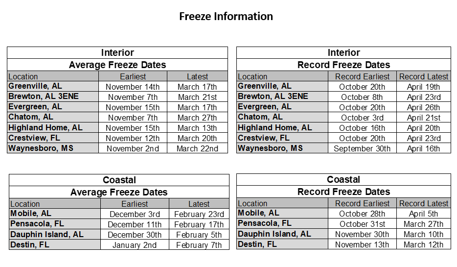
The latest outlook for December indicates a weather pattern which favors temperatures to lean above normal over the southeast US, westward to across Texas. Unfortunately Florida appears to lean below normal on seeing much needed rainfall desperately required to ease what is moderate to severe drought conditions over the western Florida Panhandle. Refer to the Drought Information link below for the latest short term trends and outlooks. The 2022 Atlantic basin hurricane season concluded with 14 named storms, 8 hurricanes, two of which became intense. Just about normal on occurrence. Refer to the link in the table below to see a summary on the hurricane season. Freeze date information is also provided in the table below.
Click on the snap shots below to expand:
 December Normals December Normals |

|

Outlook |

|
|
|
Additional Climate Links:
The links below are intended to provide additional climate information, education and outlooks. The National Weather Service Mobile Alabama's Climate and Past Weather page provides climate data at your fingertips for many observation points in the local forecast area by accessing the NOWData tab as well as many other climate resources. The Climate Prediction Center Link provides short and longer range climatic outlooks and education about the larger scale global circulations that impact temperatures and weather. With the large agriculture and farming presence along the central Gulf coast, the Drought Monitor link provides updates on drought trends and impacts. Another very helpful resource is the Community Collaborative Rain Hail and Snow (CoCoRaHS) network, which is a large group of volunteers working together to measure and map precipitation (rain, hail and snow). The aim of CoCoRaHS is to provide the highest quality data for natural resource, education and research applications. You can be a part of the CoCoRaHS team by becoming a volunteer rainfall observer. To learn more click on the CoCoRaHS link below.
National Weather Service Mobile AL Climate and Past Weather
Climate Prediction Center (CPC)
CoCoRaHS Network Water Year Summaries
![]()


