Ice accumulation from freezing rain does not coat the surface of objects evenly. Gravity will usually cause the rain water to run to the underside of an object before it freezes. Wind can create the same effect. In either case, the result would be a thicker coating of ice on one side of the object compared to the opposite side.
You can accurately estimate the thickness of the ice with the method below. You will need a ruler and possibly a piece of paper and pencil.
1. Locate an ice-covered object that is out in the open. A small tree branch in the middle of the yard is usually easiest to handle.
2. Move to a position where you can see both the thickest and thinnest portions of ice coating the object from one side to the other.
3. Using the ruler, measure the thickest part of the ice, from the edge of the object to the edge of the ice. Record that value on your paper.
4. Similarly, measure the thinnest part of the ice, from the edge of the object to the edge of the ice. Record that value on your paper.
5. Add the two values together and then divide by two. The resulting value is your ice accumulation.
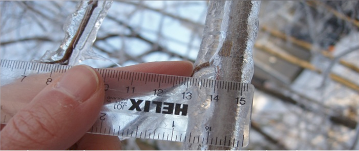
In the example below, the ice thickness on the left side of the branch is about 5/16" thick, and the thickness on the right side is about 3/16" thick (using the marks on the bottom of the ruler). Add those two numbers together and divide by two to get the average thickness of 4/16"...or about a quarter inch of ice.
A great way to report icing is to submit them via our storm reports page. This page includes many ways to submit your report, including using an online form, Facebook, X, or simply calling our office. When you report your ice thickness, be sure to let us know if you measured it on a round surface like a tree branch or on a flat surface like a deck or sidewalk. Of course, be sure to tell us your location, too! We appreciate your reports as they are critical in assisting your local National Weather Service in making decisions; reports are also entered into the National Storm Events Database. Thank you.
NWS Louisville, KY for page source information. Joe Maniscalco, NWS Mobile/Pensacola Observation Program Leader/Meteorologist.
Updated: 1/13/2024

