May 2018 Graphical Climate Summaries
Mobile Alabama and Pensacola Florida Area
Joe Maniscalco - Meteorologist/Forecaster/Climate Program Lead
National Weather Service Mobile Alabama
May 2018 in Review - Daily high temperatures at Mobile started off near seasonal to begin the month, but soon trended much above normal going into the middle of the month, leveling out closer to seasonal to end the month. Overnight lows at Mobile were unseasonably cool the first of the month, then trended above normal for much of the remainder of the month. A few record highs were reached at Mobile. Similar trends in highs and lows were also noted at Pensacola with a couple record highs being observed. Total monthly rainfall at both sites were not too far off the climatological normal for the month of May. Although the Atlantic Basin Hurricane Season officially starts in June, development from time to time does occur in May and that indeed occurred with the formation of Sub-Tropical Storm Alberto over the northwest Caribbean on Friday May 25th. Alberto made landfall just to the east of the local forecast area at Laguna Beach Florida Monday May 28th.
Mobile Alabama Area - The average monthly high was 88.8° or 4.3° above normal. The average monthly low was 65.7° or 2.0° above normal. The average monthly temperature was 77.3° or 3.2° above normal. Four record high temperatures were reached. The 8th at 91°, tied previous records set on this date in 2004, 1962, 1959, 1955, 1949, 1899, and 1882. The 10th at 91° tied previous records set on this date in 2011, 2007, 1962, and 1955. 95° on the 13th set a new record, eclipsing the previous record of 93° set back in 1962. 97° on the 14th set a new record, topping the previous record of 94° set way back in 1881. (Fig. A) shows how temperatures compared to the seasonal normal monthly highs and lows, which are shown by the colored dashed lines. May rainfall measured 5.87" or 0.73" above normal (Fig. B).
Click on the Mobile Alabama area climate graphics below to expand:


Pensacola Florida Area - The average monthly high was 87.2° or 4.0° above normal. The average monthly low was 69.5° or 3.5° above normal. The average monthly temperature was 78.4° or 3.8° above normal. Two record high temperatures were reached. The 10th at 90°, tied previous records set on this date in 2009 and 1962. 98° on the 13th set a new record, smashing the previous record of 93° set back in 2007. (Fig. C) shows how temperatures compared to the seasonal normal monthly highs and lows, which are shown by the colored dashed lines. May rainfall measured 3.73" or 0.45" below normal (Fig. D).
Click on the Pensacola Florida area climate graphics below to expand:


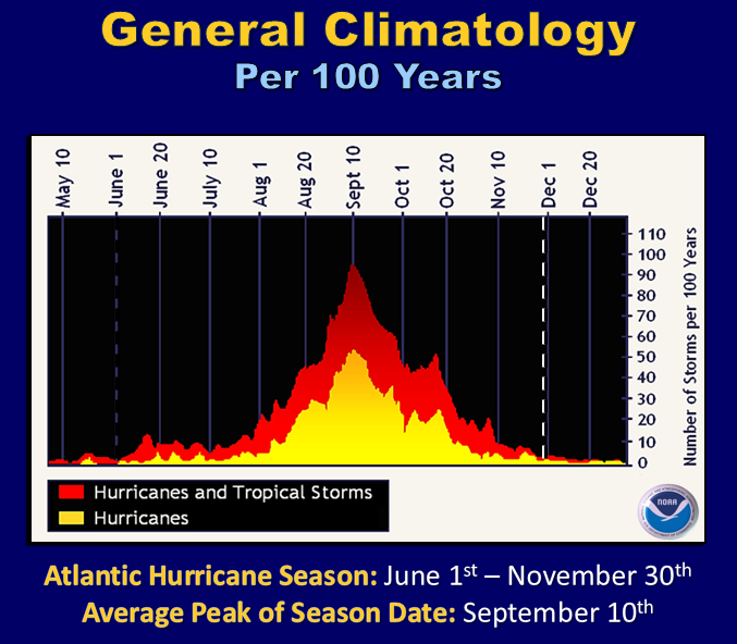
Looking Ahead to the 2018 Atlantic Basin Hurricane Season:
Forecasters are calling for a near or above normal 2018 Atlantic Hurricane Season. See the news article => NOAA's 2018 Atlantic Hurricane Season Outlook for in depth coverage. Also included in the link is a brief video from Dr. Gerry Bell, NOAA Lead Seasonal Hurricane Forecaster. The images below show the climatological origins and tracks of tropical cyclones by month along with general climatology of hurricanes/tropical storms combined.
Click on the graphics below to expand:

Additional Climate Links:
The links below are intended to provide additional climate information, education and outlooks. The National Weather Service Mobile Alabama's Climate and Past Weather page provides climate data at your fingertips for many observation points in the local forecast area by accessing the NOWData tab as well as many other climate resources. The Climate Prediction Center Link provides short and longer range climatic outlooks and education about the larger scale global circulations that impact temperatures and weather. With the large agriculture and farming presence along the central Gulf coast, the Drought Monitor link provides updates on drought trends and impacts. Another very helpful resource is the Community Collaborative Rain Hail and Snow (CoCoRaHS) network, which is a large group of volunteers working together to measure and map precipitation (rain, hail and snow). The aim of CoCoRaHS is to provide the highest quality data for natural resource, education and research applications. You can be a part of the CoCoRaHS team by becoming a volunteer rainfall observer. To learn more click on the CoCoRaHS link below.
National Weather Service Mobile AL Climate and Past Weather
Climate Prediction Center (CPC)
CoCoRaHS Network Water Year Summaries
Questions or Comments:
Contact: Joe Maniscalco, WFO Mobile, AL at joe.maniscalco@noaa.gov


