March 2019 Climate Summaries
Mobile Alabama and Pensacola Florida Area
National Weather Service Mobile Alabama
Monday April 8, 2019
March 2019 in Review - After a cold spell the first week in March, where temperatures were well below the seasonal normal, a brief rise to well above normal occurred. Temperatures then settled to closer to monthly normals the middle and latter part of the month. The Mobile and Pensacola area both saw 2 record temperatures each in the maximum department. For rainfall, it turned out very dry with both rain gauges at both the Mobile and Pensacola areas coming in shy of 2 inches for the month. This dry spell was not notably record setting, but did have impacts on soil moisture with abnormally dry conditions expanding over much of the central Gulf coast.
Mobile Alabama Area - The average monthly high of 71.1° was 0.1° below normal. The average monthly low of 49.5° was 0.4° above normal. The average monthly temperature of 60.3° was 0.1° above normal. Mobile saw 2 record temperatures, both of which being tied. A record high of 83° on the 10th tied the previous record for this date set in 1980. A record high low temperature of 70° on the 14th tied the previous record for this date set back in 1973.
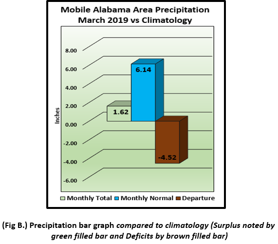
(Fig. A) shows how the Mobile area temperatures compared to the seasonal normal monthly highs and lows, which are shown by the colored dashed lines. March rainfall (Fig. B) trended much lower than February, measuring 1.62" or 4.52" below normal. 2019's accumulated rainfall through March is also provided below, bounded by the traces of all time max (year of occurrence), min (year of occurrence) and average precipitation ending for the month.
Click on the Mobile Alabama area climate graphics below to expand:

|
|

Against Climatology |
Pensacola Florida Area - The average monthly high of 70.8° was 1.2° above normal. The average monthly low of 51.6° was 0.4° above normal. The average monthly temperature of 61.2° was 0.8° above normal. Pensacola saw 2 record temperatures. A record high of 84° set on the 10th broke the previous record of 82° occurring on this date in 2017. The other record high was also 84° occurring on the 11th, which tied the previous record for this date set back in 1997.
(Fig. C) shows how the Pensacola area temperatures compared to the seasonal normal monthly highs and lows, which are shown by the colored dashed lines. Similar to that of the Mobile area, Pensacola area rainfall (Fig. D) measured 1.54" or 4.27" below normal. 2019's accumulated rainfall through March is also provided below, bounded by the traces of all time max (year of occurrence), min (year of occurrence) and average precipitation ending for the month.
Click on the Pensacola Florida area climate graphics below to expand:

|

|

Against Climatology |
April Climatology and Outlooks:
It's gardening time along the central Gulf coast and although there could be some occasional cool snaps, the risk of frost is trending much lower as we go deeper into the Spring planting season. With the coastal plain region having experienced short-term dryness over the past one to three months, areal coverage of moderate drought expanded into the western Florida Panhandle, the Alabama Gulf Coast and parts of southern Alabama. Considering this, a link to drought information has been added below which highlights short term trends, and monthly/seasonal outlooks.
Click on the snap shots below to expand:

|

Outlook |

Outlook |

Map by USDA |
|

Information |
Climate Prediction Center's Interactive Long Range Outlooks
Additional Climate Links:
The links below are intended to provide additional climate information, education and outlooks. The National Weather Service Mobile Alabama's Climate and Past Weatherpage provides climate data at your fingertips for many observation points in the local forecast area by accessing the NOWData tab as well as many other climate resources. The Climate Prediction Center Link provides short and longer range climatic outlooks and education about the larger scale global circulations that impact temperatures and weather. With the large agriculture and farming presence along the central Gulf coast, the Drought Monitor link provides updates on drought trends and impacts. Another very helpful resource is the Community Collaborative Rain Hail and Snow (CoCoRaHS) network, which is a large group of volunteers working together to measure and map precipitation (rain, hail and snow). The aim of CoCoRaHS is to provide the highest quality data for natural resource, education and research applications. You can be a part of the CoCoRaHS team by becoming a volunteer rainfall observer. To learn more click on the CoCoRaHS link below.
National Weather Service Mobile AL Climate and Past Weather
Climate Prediction Center (CPC)
CoCoRaHS Network Water Year Summaries


