June 2019 Climate Summaries
Mobile Alabama and Pensacola Florida Area
Joe Maniscalco - Meteorologist/Forecaster/Climate Program Lead
National Weather Service Mobile Alabama
July 3, 2019
June 2019 in Review - Temperatures were slightly above normal for the month of June at both Mobile and Pensacola. Although Mobile observed one record daily temperature, it equaled being the warmest low temperature on record with 3 other days from past years. Pensacola saw 4 record temperatures. Of these, 2 days equaled 4 other days from past years with the warmest low temperature on record. After a couple of dry months, rain gauges saw a surplus at both Mobile and Pensacola this month with both sites coming in above normal.
Mobile Alabama Area - The average monthly high of 91.1° was 1.9° above normal. The average monthly low of 72.2° was 1.8° above normal. The average monthly temperature of 81.7° was 1.9° above normal. Mobile saw 1 record temperature. A record high low temperature of 82° on the 21st broke the previous record of 80°on this date occurring way back in 1915. This new record now ties the warmest low temperature for the month with 3 other days, 82° on the 27th set in 1930, the 28th set in 1902, and the 30th set in 1877.
(Fig. A) shows how the Mobile area temperatures compared to the seasonal normal monthly highs and lows, which are shown by the colored dashed lines. June rainfall (Fig. B) measured 6.66" or 0.55" above normal. 2019's accumulated rainfall ending June 30th continues well below seasonal normal by several inches.
Click on the Mobile Alabama area climate graphics below to expand:

|

|
Against Climatology |
Pensacola Florida Area - The average monthly high of 91.1° was 2.6° above normal. The average monthly low of 75.4° was 2.9° above normal. When considering the average low for Pensacola, this makes June 2019 the 6th all time warmest on the period of record (p.o.r) dating back to 1879. The average monthly temperature of 83.3° was 2.8° above normal. When considering the average temperature, June 2019 at Pensacola now stands as 4th warmest in the p.o.r. A record high of 98° on the 3rd broke the previous record of 95° occurring on this date in 1968. A record high low temperature was observed on 3 days. 81° on the 20th tied the previous record set in 1990. 82° on the 21st broke the previous record of 81° set in 2009. Also 82° on the 24th tied the previous record set in 1930. The record high lows set on the 21st and 24th ties the warmest low temperature for the month with 4 other days, 82° on the 25th set in 1905, the 27th set in 1957, the 28th set in 1902, and the 30th occurring in 1954.
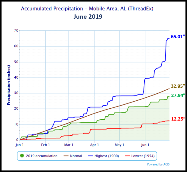
(Fig. C) shows how the Pensacola area temperatures compared to the seasonal normal monthly highs and lows, which are shown by the colored dashed lines. Pensacola area rainfall (Fig. D) measured 7.64" or 1.04" above normal. 2019's accumulated rainfall ending June 30th indicates a substantial deficit by a little over 8 inches below the seasonal normal.
Click on the Pensacola Florida area climate graphics below to expand:

|

|

Against Climatology |
July Climatology and Outlooks:
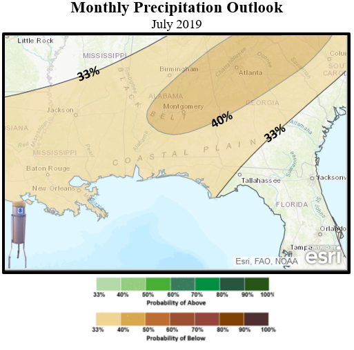
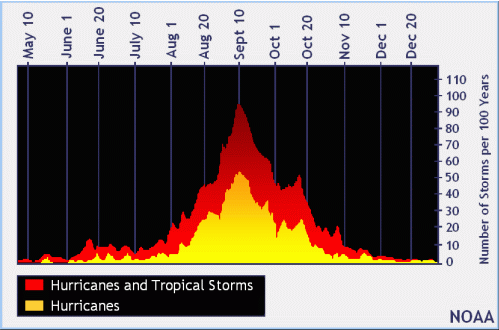
The long term weather outlook favors an unseasonably warm and dry pattern along the central Gulf coast for July. A quiet Atlantic Basin hurricane season thus far, but not too far off till we begin to approach the climatological peak in tropical cyclone activity a month away. NOAA predicts a near normal season. This outlook reflects competing climate factors. The ongoing El Niño is expected to persist and suppress the intensity of the hurricane season. Countering El Niño is the expected combination of warmer-than-average sea-surface temperatures in both the tropical Atlantic Ocean and Caribbean Sea along with an enhanced west African monsoon, both of which favor increased hurricane activity. Links to the outlook and tropical climatology are provided below.
Click on the snap shots below to expand:

|

Outlook |
Outlook |
Climatology |
Hurricane Outlook |
|
Climate Prediction Center's Interactive Long Range Outlooks
Additional Climate Links:
The links below are intended to provide additional climate information, education and outlooks. The National Weather Service Mobile Alabama's Climate and Past Weatherpage provides climate data at your fingertips for many observation points in the local forecast area by accessing the NOWData tab as well as many other climate resources. The Climate Prediction Center Link provides short and longer range climatic outlooks and education about the larger scale global circulations that impact temperatures and weather. With the large agriculture and farming presence along the central Gulf coast, the Drought Monitor link provides updates on drought trends and impacts. Another very helpful resource is the Community Collaborative Rain Hail and Snow (CoCoRaHS) network, which is a large group of volunteers working together to measure and map precipitation (rain, hail and snow). The aim of CoCoRaHS is to provide the highest quality data for natural resource, education and research applications. You can be a part of the CoCoRaHS team by becoming a volunteer rainfall observer. To learn more click on the CoCoRaHS link below.
National Weather Service Mobile AL Climate and Past Weather
Climate Prediction Center (CPC)
CoCoRaHS Network Water Year Summaries
Questions or Comments:
Contact: Joe Maniscalco, WFO Mobile, AL at joe.maniscalco@noaa.gov


