July 2022 Climate Summaries
Mobile Alabama and Pensacola Florida Area
National Weather Service Mobile Alabama
August 4, 2022
July 2022 in Review - Average high temperatures at Mobile were the closest to seasonal normals at a little less than a half degree off the pace with lows coming in just shy of two degrees above normal. No record temperatures were reached or set at Mobile. At Pensacola, July started off on the "cool" side, where highs on the first day of the month came in seven degrees below normal before a notable, steady rise with each day thereafter to above normal by the first portion of the second week. Lows were shy of two degrees above normal. During a three day stretch were lows were in the balmy lower 80's during the middle of the month, Pensacola saw a new record high low temperature being broken.
Much of the month was unsettled with 68% and 65% of the month observing measurable rain (Greater than or equal to 0.01") at Mobile and Pensacola, respectively. In fact, considering three of the four metrics of daily rain amounts meeting or exceeding, 0.01", 0.10", 0.50", and 1.00", Mobile saw daily occurrences well above normal in the first three categories and Pensacola was above normal in all four. Despite nearly 10" of July rainfall at Mobile, annual rainfall thus far remains in deficit. The same cannot be said for Pensacola, where over 11" of rain brings the annual surplus to several inches above normal.
Mobile Alabama Area [Climate Normal Period 1991-2020, Climate Record Period 1872 to Present]- The average monthly high of 91.1° was 0.2° above normal. The average monthly low was 74.9° or 1.8° above normal. The average monthly temperature of 83.0° was 1.0° above normal. The highest temperature for the month, 95° on the 9th and 11th was 4° above the normal for these days. The lowest temperature for the month, 71° on the 11th, was just 2° below normal for this date. No record temperatures were reached. (Fig. A) shows a graphical representation of how the Mobile area temperatures compared to the seasonal normal daily highs and lows, which are shown by the colored dashed lines. Bar graphs reflecting the daily high/low temperature departures from normal are provided in the table below (Figs. B and C). The rain gauge collected just shy of 10" for the month at 9.89" (Fig. D), 2.20" above normal. A bar graph showing the number of days of occurrence of select precipitation amounts compared to climatological normals is also provided in (Fig. D). Annual rainfall to date has risen to just south of 38" (Fig. E) but remains in deficit off the normal annual accumulation by a little over 3".
July top records for the month during the Period of Record for the Mobile Area:
Click on the Mobile Alabama area climate graphics below to expand:

|

|

|

|

|
Pensacola Florida Area [Climate Normal Period 1991-2020, Climate Record Period 1879 to Present] - The average monthly high of 89.9° was 1.7° below normal. The average monthly low was 77.1° or 1.8° above normal. The average monthly temperature of 83.5° was normal. The highest temperature for the month, 94° on the 9th and 10th was just 2° above the normal daily high temperature for these days. The lowest temperature for the month, 74° on the 1st, was 1° below the normal daily low temperature for this date. A new record temperature was set and that was a record high low temperature of 82° occurring on the morning of the 19th. This broke the previous record high low of 81° set on this date back in 1934. (Fig. F) shows a graphical representation of how the Pensacola area temperatures compared to the seasonal normal daily highs and lows, which are shown by the colored dashed lines. (Figs. G and H) shows the daily high/low temperature departures from normal. Quite a bit of rain was collected at 11.17" (Fig. I), or 3.28" above normal for July rainfall. A bar graph showing the number of days of occurrence of select precipitation amounts compared to climatological normal is also shown in (Fig. I). The surplus in annual rainfall has risen to just a hair below a half foot above normal to date. (Fig. J).
July top records for the month during the Period of Record for the Pensacola Area:
Click on the Pensacola Florida area climate graphics below to expand:

|

|

|

|

|
Additional July 2022 Climatology and Topics
The latest July 2022 monthly summary for Eglin Air Force Base (AFB) - KVPS and Duke Field - KEGI has been received and provided in the table below. The temperatures in the daily tables consists of numbers both in °F/°C. Data courtesy of Mr. David Biggar, Staff Meteorologist, 96th Weather Squadron. Provided by permission.

|

|

|
August 2022 Climatology, Seasonal Climatology and Outlooks:
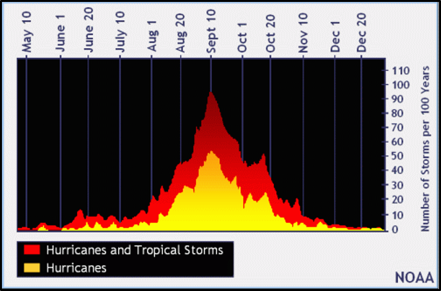
The latest outlook for August is leaning above normal on temperatures over much of the deep south, moving up a category of being likely above normal west of the Lower Mississippi River Valley. Equal chances of above or below normal precipitation is favored over the deep south. Precipitation for 2022 thus far has kept any increase in drought tendencies over the deep south in check as the monthly outlook for August is in good shape. We are now entering the typical peak of the Atlantic Basin Hurricane Season in August and September. NOAA continues to predict an above-normal hurricane season from the August 4th update. This doesn't mean that the central Gulf coast will be directly impacted by a tropical system but serves as a reminder that all it takes is one storm to make it a bad year. It's highly encouraged to review your hurricane preparedness, see link below.
Click on the snap shots below to expand:
 August Normals August Normals |

|

Outlook |

|

|
|

|
Additional Climate Links:
The links below are intended to provide additional climate information, education and outlooks. The National Weather Service Mobile Alabama's Climate and Past Weather page provides climate data at your fingertips for many observation points in the local forecast area by accessing the NOWData tab as well as many other climate resources. The Climate Prediction Center Link provides short and longer range climatic outlooks and education about the larger scale global circulations that impact temperatures and weather. With the large agriculture and farming presence along the central Gulf coast, the Drought Monitor link provides updates on drought trends and impacts. Another very helpful resource is the Community Collaborative Rain Hail and Snow (CoCoRaHS) network, which is a large group of volunteers working together to measure and map precipitation (rain, hail and snow). The aim of CoCoRaHS is to provide the highest quality data for natural resource, education and research applications. You can be a part of the CoCoRaHS team by becoming a volunteer rainfall observer. To learn more click on the CoCoRaHS link below.
National Weather Service Mobile AL Climate and Past Weather
National Weather Service Mobile AL Climate Summary Monthly Archives
Climate Prediction Center (CPC)
CoCoRaHS Network Water Year Summaries


