July 2018 Graphical Climate Summaries
Mobile Alabama and Pensacola Florida Area
Joe Maniscalco - Meteorologist/Forecaster/Climate Program Lead
National Weather Service Mobile Alabama
July 2018 in Review - Similar to the month of June, average high and low temperatures at Mobile and Pensacola for July came in slightly above seasonal. One record high low temperature was broken at Mobile and one was tied at Pensacola. The rain gauge at both Mobile and Pensacola collected rainfall that was just shy of normal.
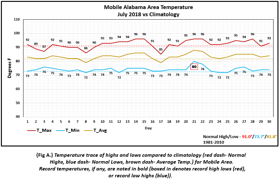
Mobile Alabama Area - The average monthly high was 92.0° or 1.0° above normal. The average monthly low was 74.2° or 1.5° above normal. The average monthly temperature was 83.1° or 1.3° above normal. A record high low temperature was broken on the 21st, at 80°. The previous record of 79° occurred on this day in 1942. (Fig. A) shows how temperatures compared to the seasonal normal monthly highs and lows, which are shown by the colored dashed lines. July rainfall measured 6.96" or 0.29" below normal (Fig. B). The total rainfall year to date (Not graphically shown) now stands at 36.18" or 4.02" below normal.
Click on the Mobile Alabama area climate graphics below to expand:

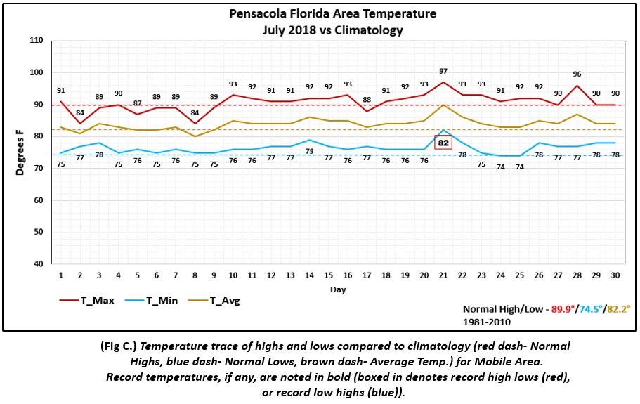
Pensacola Florida Area - The average monthly high was 90.7° or 0.8° above normal. The average monthly low was 76.5° or 2.0° above normal. The average monthly temperature was 83.6° or 1.4° above normal. A record high low temperature was tied on the 21st, 82°. The last time this occurred on this date was way back in 1924.(Fig. C) shows how temperatures compared to the seasonal normal monthly highs and lows, which are shown by the colored dashed lines. July rainfall measured 6.79" or 0.62" below normal (Fig.D). The total year to date total rainfall(Not graphically shown) now stands at 38.30" or 0.29" above normal.
Click on the Pensacola Florida area climate graphics below to expand:

Outlook for August:
A slight chance of unseasonal warmth is favored to continue over the coastal plain with equal chances of above or below normal temperatures just to the north. Precipitation is favored to also be above normal. (Graphics courtesy of CPC and esri)
Click on the graphics below to expand:


Climate Prediction Center's Interactive Long Range Outlooks
Heading into the Peak of the 2018 Atlantic Basin Hurricane Season:
We are now moving into the season when tropical cyclone activity begins to increase. Tropical cyclone activity origin can occur from the central Atlantic, westward across the Caribbean to the Gulf and over the Gulf Stream off the US Atlantic coast during the month of August. Notice the substantial increase in number of tropical cyclone occurrences and corresponding percentage distributions for the Atlantic Basin Hurricane Season (June to November from 1851 to 2017) in the graphs below.
Click on the graphics below to expand:


Additional Climate Links:
The links below are intended to provide additional climate information, education and outlooks. The National Weather Service Mobile Alabama's Climate and Past Weather page provides climate data at your fingertips for many observation points in the local forecast area by accessing the NOWData tab as well as many other climate resources. The Climate Prediction Center Link provides short and longer range climatic outlooks and education about the larger scale global circulations that impact temperatures and weather. With the large agriculture and farming presence along the central Gulf coast, the Drought Monitor link provides updates on drought trends and impacts. Another very helpful resource is the Community Collaborative Rain Hail and Snow (CoCoRaHS) network, which is a large group of volunteers working together to measure and map precipitation (rain, hail and snow). The aim of CoCoRaHS is to provide the highest quality data for natural resource, education and research applications. You can be a part of the CoCoRaHS team by becoming a volunteer rainfall observer. To learn more click on the CoCoRaHS link below.
National Weather Service Mobile AL Climate and Past Weather
Climate Prediction Center (CPC)
CoCoRaHS Network Water Year Summaries
Questions or Comments:
Contact: Joe Maniscalco, WFO Mobile, AL at joe.maniscalco@noaa.gov


