January 2025 Climate Summaries
Mobile Alabama and Pensacola Florida Area
Joe Maniscalco - Observation Program Leader (OPL)/Meteorologist
POC for Observation, Climate, and COOP
National Weather Service Mobile Alabama
February 3, 2025
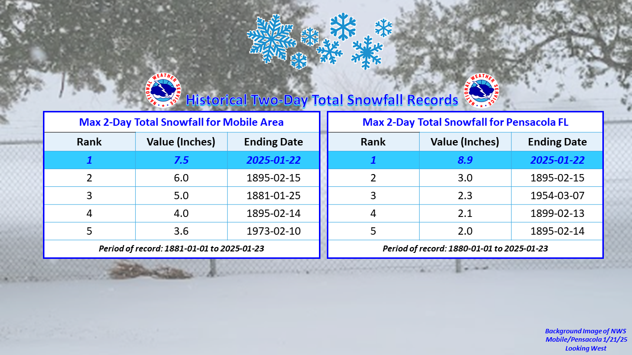
January 2025 in Review - The top weather news for the month of January was a historic winter storm on the 21st that dropped record snowfall along the central Gulf Coast. More on this shortly. Monthly temperatures were well below climatology in all three averages of the metrics, highs, lows, and means at both Mobile and Pensacola. We did have our warm spells, at above normal temperatures which is typical, but the colder periods lasted for unusually longer durations. The first came following the passage of a strong cold front on January 6th, with high temperatures at Mobile averaging 12.8° below normal from the 7th to the 12th and lows from the 6th to the 12th 10.6° below normal. Pensacola's highs averaged 12.0° below normal from the 7th to the 13th and lows from the 6th to the 12th 11.6° below normal. The most significant colder spike in temperatures came as an arctic high became situated from the southern Plains to the Mid-Mississippi River Valley beginning January 20th. From that day to the 22nd, Mobile's highs averaged an astounding 24.3° below normal with lows from the 20th to the 25th at 21.7° below normal. Pensacola saw daily highs averaging an incredible 25.0° below normal from the 20th to the 22nd with lows from the 20th to the 25th, 20.8° below normal. Mobile did take a seat at the record table rankings at the 10th coldest average monthly low. A historic snowstorm transformed the northern Gulf Coast into a winter wonderland on the 21st. This snowstorm shattered longstanding snowfall records across the region, including the nearly 130-year-old snowfall records that were set during the February Snowstorm of 1895. Details of the snowfall records will come in the Mobile and Pensacola area breakout. Note: The 2-Day records were researched to capture like events that typically lasted two days. Following the winter storm, Mobile and Pensacola broke a record low, while also experiencing a record low high temperature on the 22nd.
Rainfall for the month of January at Mobile was in deficit by well over an inch. Pensacola did see a small surplus against the normal with one day of record, excessive rainfall on the 10th helping things along.
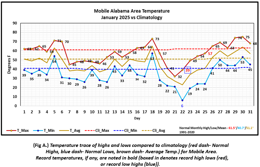
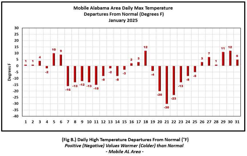
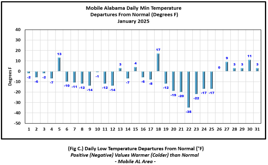
Mobile Alabama Area [Climate Normal Period 1991-2020, Climate Record Period 1872 to Present]- The average monthly high of 57.8° was 3.7° below normal. The average monthly low was 34.6° or 6.1° below normal and stands as the 10th coldest January's on record. The average monthly temperature of 46.2° was 4.9° below normal. The highest temperature for the month was reached on the 30th at 75°, 12° above the normal for the day. A record low high temperature occurred on the 22nd at 39°, 23° below normal for the date. This matched the previous record of occurrence on this date set back in 1935. The lowest temperature for the month plunged to a bitter cold 6° on the morning of the 22nd, a staggering 35° below normal and record breaking for the date. This smashed the previous record for the date at 16° in 1985. This low also ties for the third coldest low temperature on record, tying the last occurrence from way back in February 12, 1899. The all-time record low for Mobile is -1° set on February 13, 1899. This is only the 11th time on record Mobile has recorded a single digit low. (Fig. A) shows a graphical representation of how the Mobile area temperatures compared to the seasonal normal daily highs and lows, which are shown by the colored dashed lines. Bar graphs reflecting the daily high/low temperature departures from normal are provided in the table below (Figs. B and C).
Snowfall January 21st at Mobile Regional Airport set a new 2-Day snowfall record with an impressive 7.5" of measured snow. This surpassed the previous 2-Day snowfall record of 6.0 inches of snow, which had stood since the February 15th Snowstorm of 1895. Click on the following Link => Top Five Record Snowfalls for details.
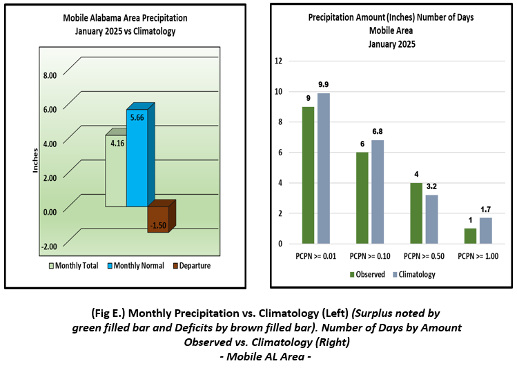
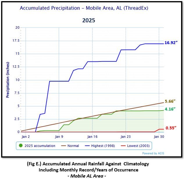
The rain gauge recorded 4.16" (Fig. D), or 1.50" below normal. Accumulated rainfall climatology for Mobile is provided in (Fig. E).
January Top Records for the Month During the Period of Record for the Mobile Area:
Click on the Mobile Alabama area climate graphics below to expand:
|
|
|
|
|
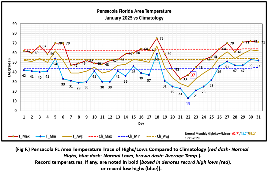
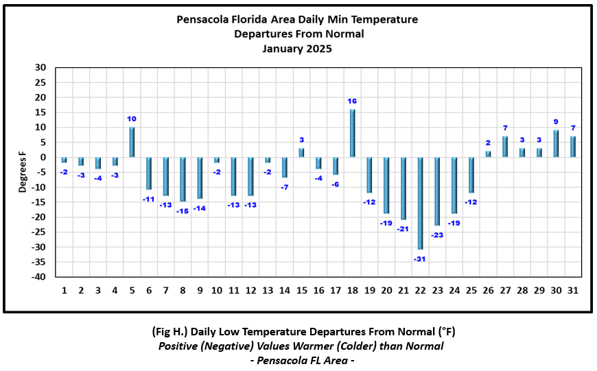
Pensacola Florida Area [Climate Normal Period 1991-2020, Climate Record Period 1879 to Present] - The average monthly high of 57.9° was 4.8° below normal. The average monthly low was 37.6° or 6.1° below normal. The average monthly temperature of 47.7° was 5.5° below normal. The highest temperature for the month was reached on the 18th at 75°, 12° above the normal for the date. Just a few days later the bottom fell out as a new record low high temperature occurred on the 22nd at 37°, 26° below normal for the date. This broke the previous record of 41° set on this date back in 1918 and 1940. The lowest temperature for the month plunged to a frigid and record breaking 13° on the morning of the 22nd and an astounding 31° below normal for this date. This crushed the previous record of 20° set on this date back in 1935. (Fig. F) shows a graphical representation of how the Pensacola area temperatures compared to the seasonal normal daily highs and lows, which are shown by the colored dashed lines. (Figs. G and H) shows the daily high/low temperature departures from normal.
Snowfall on January 21st at Pensacola set a new 2-Day snowfall record with an impressive 8.9" of measured snow. This easily overtook the previous 2-day snowfall record of 3.0 inches of snow, which had stood since the February 15th Snowstorm of 1895. Click on the following Link => Top Five Record Snowfalls for details.
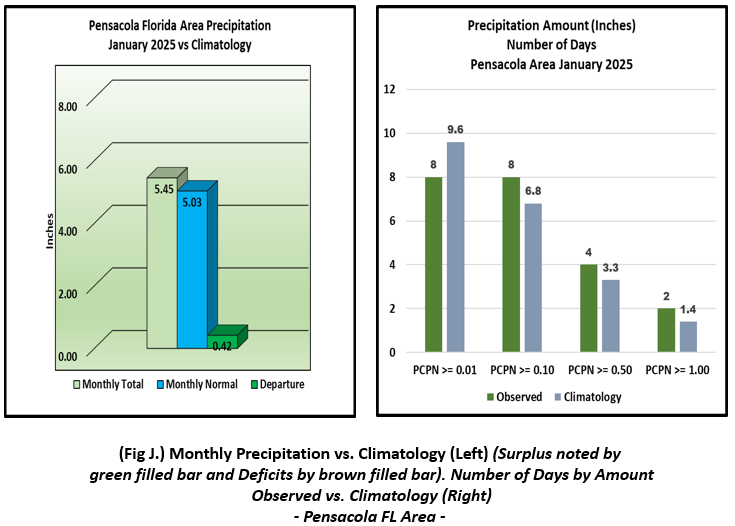
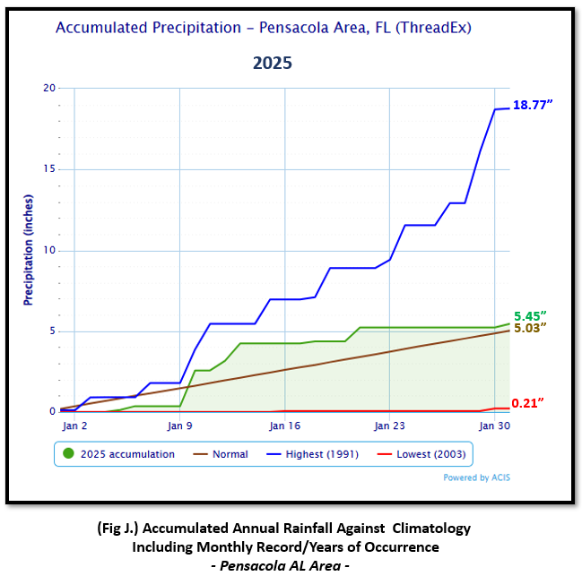
The rain gauge collected 5.45" (Fig. I), 0.42" above the monthly normal. January 10th saw a new daily record rainfall reached when 2.21" was recorded. This topped the previous daily record for the date of 2.08" occurring in 1991. Accumulated rainfall climatology for Pensacola is provided in (Fig. J).
January Top Records for the Month During the Period of Record for the Pensacola Area:
Click on the Pensacola Florida area climate graphics below to expand:
|

|
|
|
|
Additional January 2025 Climatology and Topics
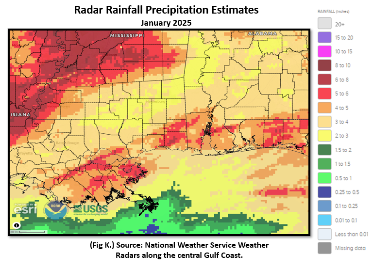
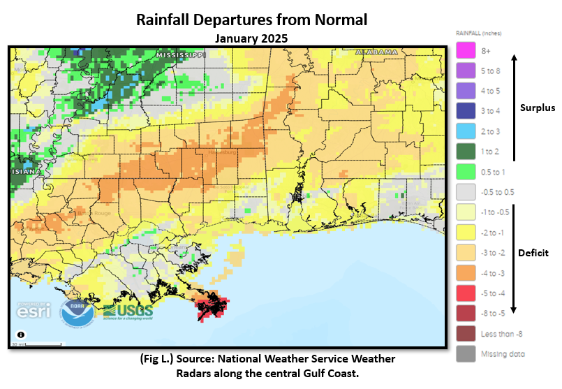
The better rainfall over the central Gulf coast was focused along the coastal counties with lesser amounts noted over the interior. (Fig. K) shows the areal monthly rainfall total, (Fig. L) shows the areal rainfall departures from normal and (Fig. M), the areal percent of normal rainfall.
The latest January 2025 Monthly Climate Summary for Eglin Air Force Base (KVPS) and Duke Field (KEGI) has been provided courtesy of Mr. David Biggar, Staff Meteorologist, 96th Weather Squadron. Provided by permission.
|
|

|
February 2025 Climatology, Seasonal Climatology and Outlooks:
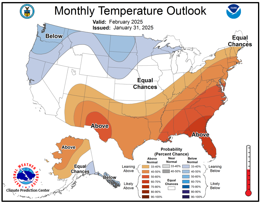
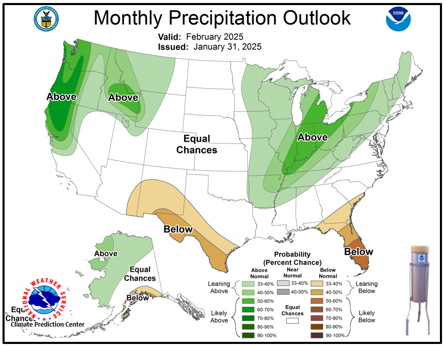
The latest outlook for February favors temperatures to likely be above normal over the southeast US. The pattern favors precipitation to lean below normal over the Florida Peninsula with equal chances of above or below normal precipitation westward over the central Gulf coast.
Click on the snap shots below to expand:
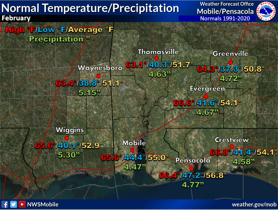 February Normals February Normals |
|
Outlook |

|

|
Additional Climate Links:
The National Weather Service Mobile Alabama's Climate and Past Weather page provides climate data at your fingertips for many observation points in the local forecast area by accessing the NOWData tab as well as many other climate resources. The Climate Prediction Center Link provides short and longer range climatic outlooks and education about the larger scale global circulations that impact temperatures and weather. With the large agriculture and farming presence along the central Gulf coast, the Drought Monitor link provides updates on drought trends and impacts. Another very helpful resource is the Community Collaborative Rain Hail and Snow (CoCoRaHS) network, which is a large group of volunteers working together to measure and map precipitation (rain, hail, and snow). The aim of CoCoRaHS is to provide the highest quality data for natural resource, education and research applications. You can be a part of the CoCoRaHS team by becoming a volunteer rainfall observer.
Questions or Comments:
Contact: Joe Maniscalco - Observation Program Leader WFO Mobile, AL at joe.maniscalco@noaa.gov


