January 2021 Climate Summaries
Mobile Alabama and Pensacola Florida Area
National Weather Service Mobile Alabama
February 5, 2021
January 2021 in Review - The Mobile area saw a lengthy cold spell through the first 19 days of the month, as far as low temperatures were concerned, where lows averaged just shy of 8.5° below normal through this period. There was a brief span of cold daytime maximums from the 8th to the 12th were the average high temperature of 43.6° was just shy of 17° below normal. Outside of these extremes, the monthly average temperature for the Mobile area leveled off to near normal helped by moderating temperatures at the close of the month. The Pensacola area saw a notable period of cold high temperatures the second week. This was followed by another notable period, this time, a lengthy period of unseasonably warm January temperatures the latter half of the month. As was the case for the Mobile area, Pensacola saw a brief span of cold daytime maximums from the 8th to the 12th where the average high temperature of 48.2° was just shy of 12° below normal. A moderating trend to well above normal temperatures followed. High temperatures from the 19th to the 27th averaged near 70°, about 9° above normal. Overnight lows from the 20th to the 28th, averaging near 55°, was 12.2° above normal. The monthly average temperature for the Pensacola area came in at around 2° above normal. Considering the extremes at both Mobile and Pensacola, surprisingly, no record temperatures were reached. Precipitation was sorely lacking at Mobile, where the rain gauge was shy by several inches off the normal. Pensacola also recorded a deficit, but not as great as Mobile.
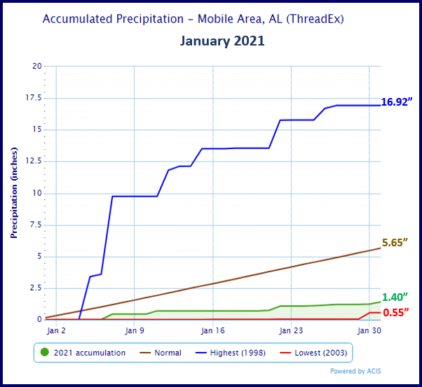
Mobile Alabama Area [Climate Normal Period 1981-2010, Climate Record Period 1872 to Present]- The average monthly high of 61.1° was 0.3° above normal. The average monthly low was 40.5° or 0.5° above normal. The average monthly temperature of 50.8° was 0.4° above normal. The highest temperature for the month, 75°, occurred on both the 25th and 31st, 14° and 13° above the normal daily high temperature respectively. The lowest temperature, 25°, occurred on the 10th, 15° below the normal daily low temperature. (Fig. A) shows a graphical representation of how the Mobile area temperatures compared to the seasonal normal daily highs and lows, which are shown by the colored dashed lines. Total rainfall for January (Fig. B) measured 1.40", 4.25" below normal.
January top records for the month during the Period of Record for the Mobile Area:
Click on the Mobile Alabama area climate graphics below to expand:

|

|
|
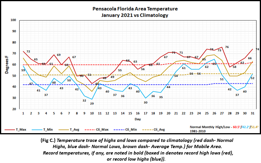
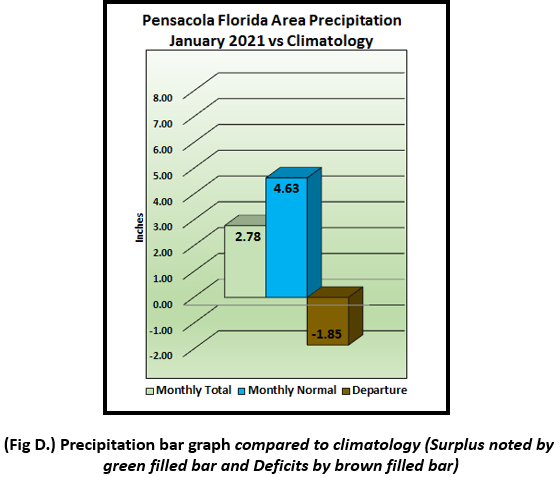
Pensacola Florida Area [Climate Normal Period 1981-2010, Climate Record Period 1879 to Present] - The average monthly high of 62.8° was 2.3° above normal. The average monthly low of 44.8° was 2.6° above normal. The average monthly temperature of 53.8° was 2.4° above normal. The highest temperature for the month was 76°, occurring on the 27th, 16° above the normal daily high temperature. The lowest temperature for the month, 29°, occurred on the 10th, or 13° below the normal daily low temperature. (Fig. C) shows a graphical representation of how the Pensacola area temperatures compared to the seasonal normal daily highs and lows, which are shown by the colored dashed lines. Measuring a bit more than the Mobile area, (Fig. D) Pensacola received 2.78" of rain which was 1.85" inches below normal.
November top records for the month during the Period of Record for the Pensacola Area:
Click on the Pensacola Florida area climate graphics below to expand:
|
|

|
February 2021 Climatology, Seasonal Climatology and Outlooks:
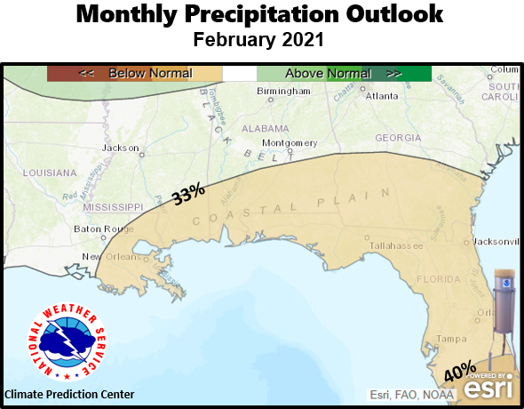
The latest monthly outlook for temperatures favors equal chances of above/below normal temperatures over the coastal plain. These can include occurrences of freezing conditions which will be detrimental to sensitive outdoor plants if not protected. La Niña is projected to carry on through the winter and into Spring. This typically favors below normal precipitation as storm tracks shift toward the Ohio Valley and the interior New England States. Considering this, the prospects of much needed rainfall is not too promising with a 33% probability of below normal rainfall favored. With recent rainfall, or lack thereof over much of the region, latest forecasts of drought tendencies favor drought development over the Lower Alabama/Tombigbee Valleys of the coastal plain. With the growing season kicking into higher gear the next couple of months, growers and agricultural agencies will need to monitor drought conditions closely as drought management protocols may become required. The link to the latest drought information and outlooks are included in the table below. We are also beginning to enter the favored climatological severe weather season over the Gulf coast. Severe weather and local tornado climatology have both been included in the table below.
Click on the snap shots below to expand:

|

Outlook |
Outlook |
|

|

|
Additional Climate Links:
The links below are intended to provide additional climate information, education and outlooks. The National Weather Service Mobile Alabama's Climate and Past Weather page provides climate data at your fingertips for many observation points in the local forecast area by accessing the NOWData tab as well as many other climate resources. The Climate Prediction Center Link provides short and longer range climatic outlooks and education about the larger scale global circulations that impact temperatures and weather. With the large agriculture and farming presence along the central Gulf coast, the Drought Monitor link provides updates on drought trends and impacts. Another very helpful resource is the Community Collaborative Rain Hail and Snow (CoCoRaHS) network, which is a large group of volunteers working together to measure and map precipitation (rain, hail and snow). The aim of CoCoRaHS is to provide the highest quality data for natural resource, education and research applications. You can be a part of the CoCoRaHS team by becoming a volunteer rainfall observer. To learn more click on the CoCoRaHS link below.
National Weather Service Mobile AL Climate and Past Weather
Climate Prediction Center (CPC)
CoCoRaHS Network Water Year Summaries


