
Major Hurricane Ida
Tornado Summaries
Summary of all Local Storm Reports (LSRs) across the area during Hurricane Ida, as well as all the LSRs across the region for this event (regional map may take a minute to load).
Storm survey teams preliminarily concluded that there was one EF-1 tornado that impacted Mobile County in AL and one EF-1 tornado that impacted Clarke County in AL. Based on radar estimates, the tornado in Saraland (Mobile County) could have continued further into the river delta in Mobile County.
Many thanks to the local EMA and Alabama Law Enforcement Agency for their assistance during our damage surveys in the aftermath of Claudette.
----- IMPORTANT 2023 UPDATE -----
Significant updates were made to several tornado tracks and wind swaths impacting the NWS Mobile/Pensacola area in the 2018 to 2023 timeframe thanks to the introduction of high-resolution Sentinel, Worldview, and Planet satellite imagery. One or multiple tornado tracks/wind swaths listed on this event webpage were updated in 2023.
An updated graphic and details surrounding these significant updates can be found in the list below. More information on this Local Tornado Reanalysis Project and a list of all updates can be found on our webpage at weather.gov/mob/TornadoReanalysis or the National Damage Viewer.
Here is a list of the significant updates:
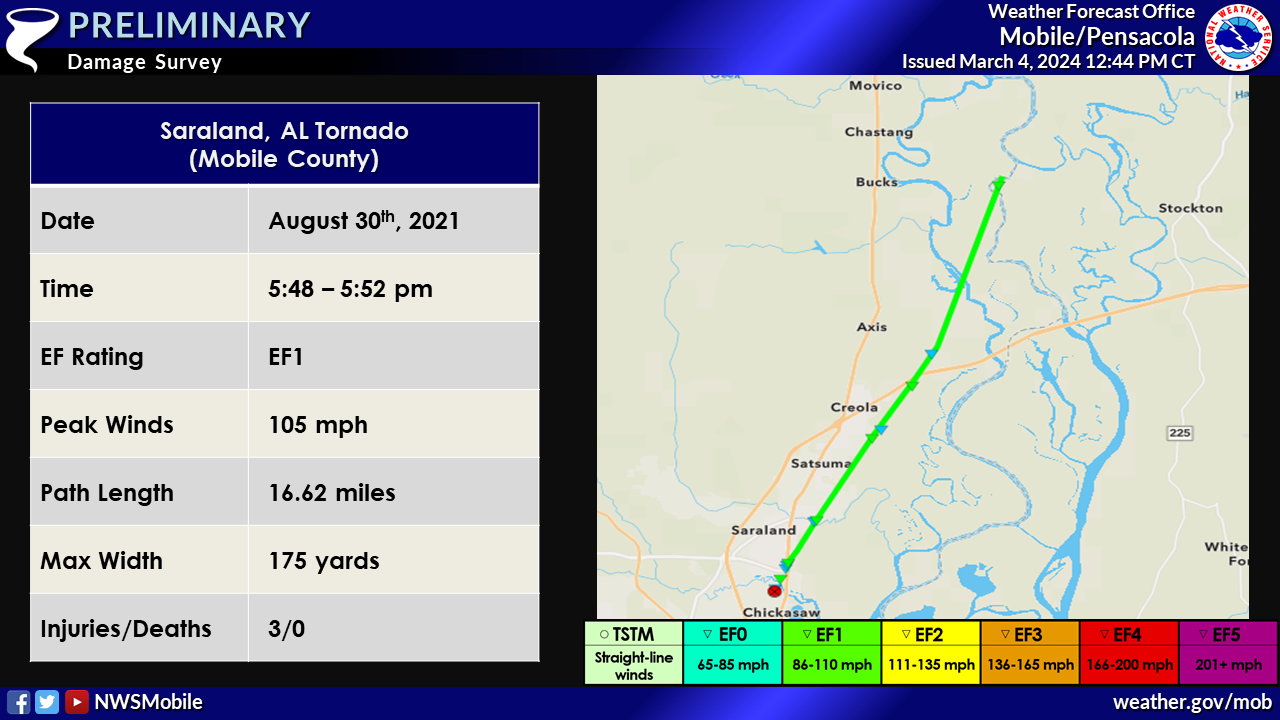
1. August 30, 2021 - Updated Tornado - Mobile County, AL: The length of the tornado that moved through parts of Saraland, Satsuma, and Creola was extended based on a narrow swath of uprooted and snapped trees noted on Planet and Worldview satellite imagery. The ending point was extended further to the northeast into the Mobile River Delta (just east of the Bucks community).
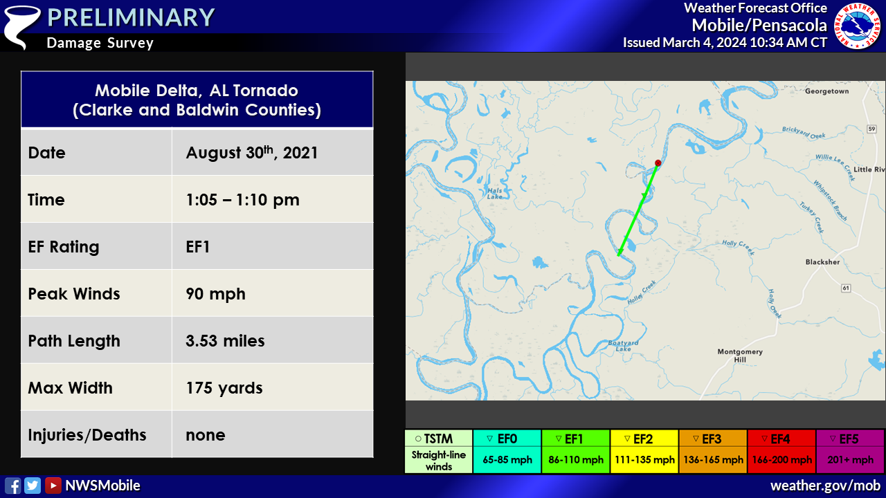
2. August 30, 2021 - New Tornado - Baldwin/Clarke Counties, AL: A new EF1 tornado was found along the Alabama River at the Baldwin/Clarke County line based on a narrow swath of tree damage noted on Planet and Worldview satellite imagery. The tornado length is 3.53 miles, width is 175 yards, and maximum intensity is 90 mph.
Saraland EF-1 Tornado

Public Information Statement
National Weather Service Mobile AL
741 PM CDT Tue Aug 31 2021
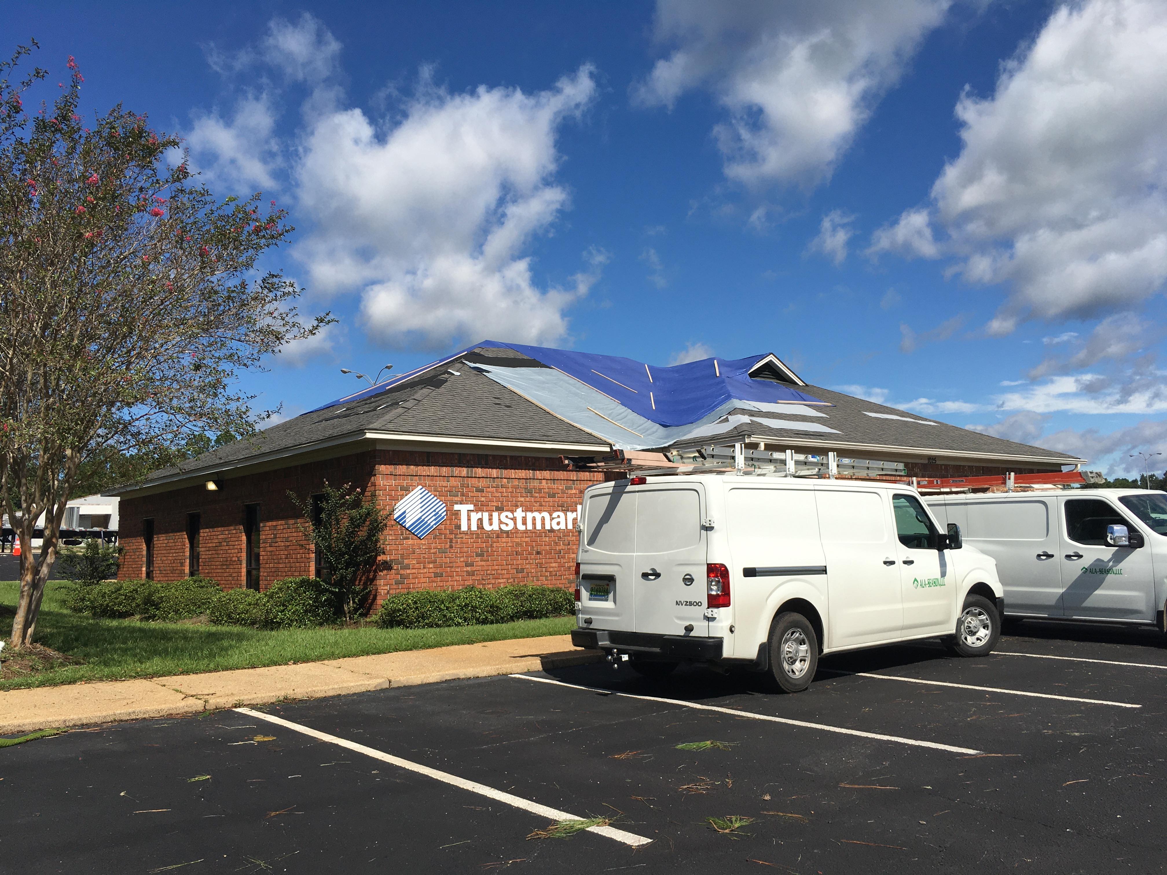
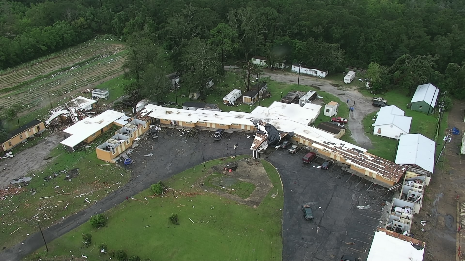
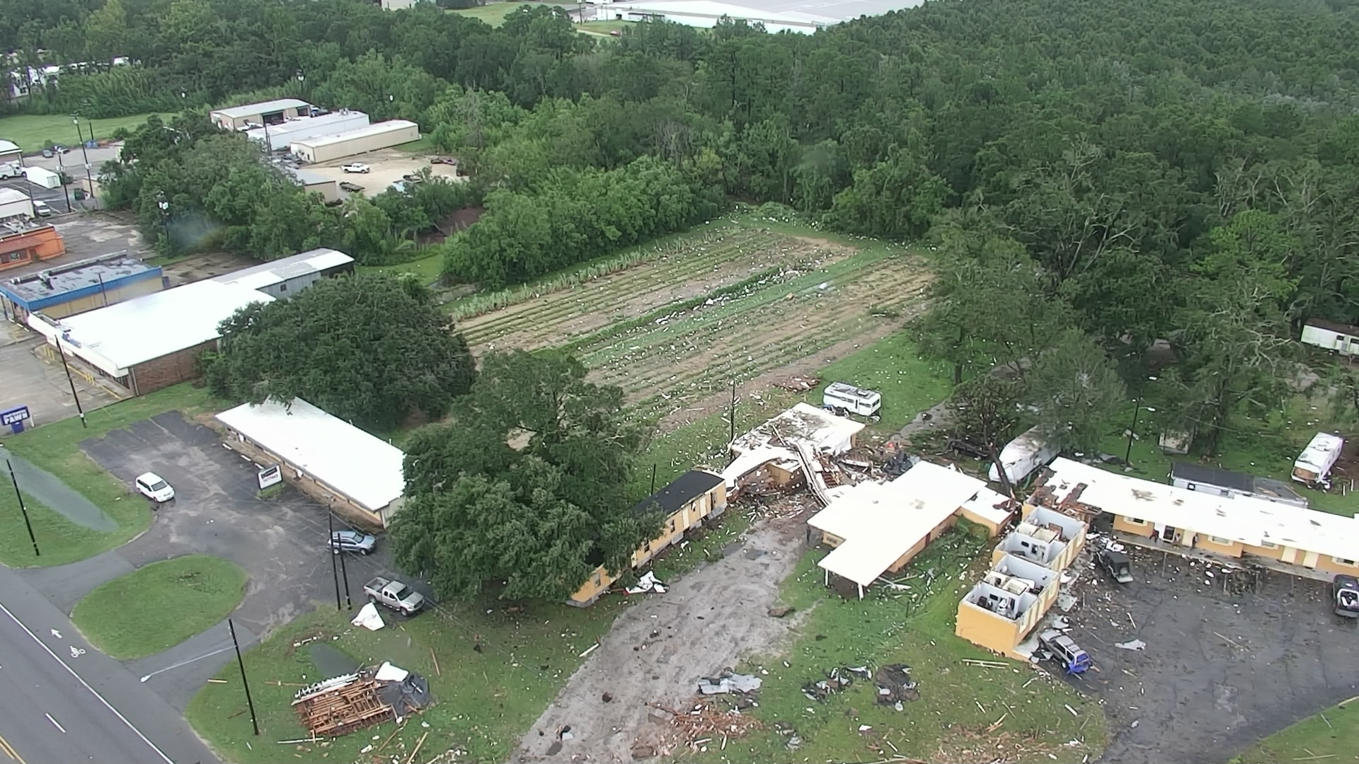
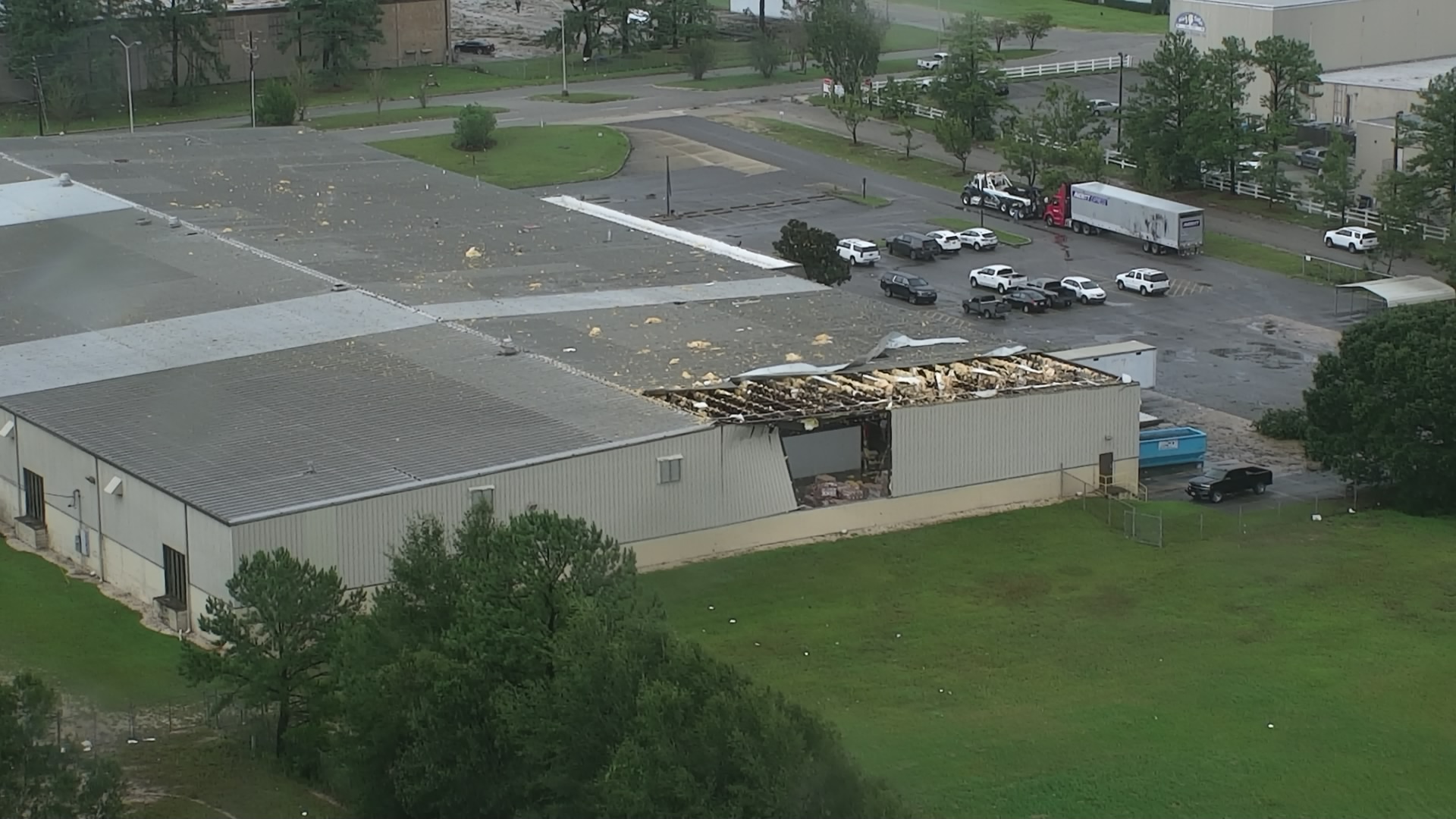
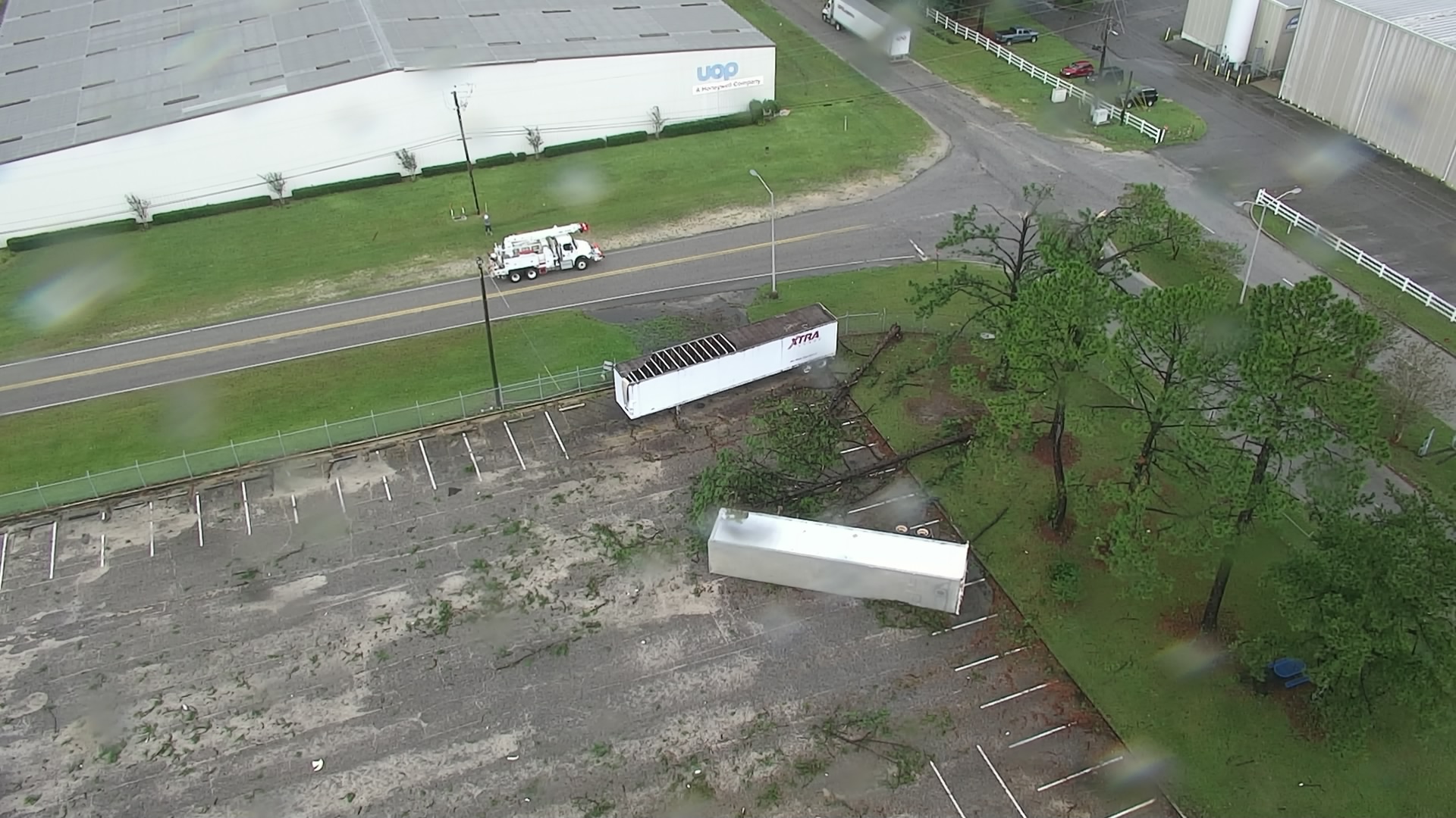
..Saraland to Creola Alabama Tornado...

Rating:                 EF1
Estimated Peak Wind:    105 mph
Path Length /statute/:  9.9577 miles
Path Width /maximum/:   175.0 yards
Fatalities:             0
Injuries:               3

Start Date:             08/30/2021
Start Time:             12:20 PM CDT
Start Location:         2 S Saraland / Mobile County / AL
Start Lat/Lon:          30.7951 / -88.0731

End Date:               08/30/2021
End Time:               12:34 PM CDT
End Location:           2 E Axis / Mobile County / AL
End Lat/Lon:            30.9212 / -87.9919

Survey Summary:
The tornado began at approximately 12:20 PM at the intersection of highway
158 and highway 43 where trees were uprooted and a few pines snapped. As the
tornado moved northeast along highway 43 it produced sporadic damage to trees.
The roof of a motel on the west side of highway 43 was uplifted and partially
removed. As the tornado crossed 43 the most intense damage occured where several
sections of another motel`s roof was removed, one person had minor injuries at the
motel. Due to the roofs older build and lack of tree damage, a lower bound estimate
was used. The tornado continued northeast and crossed Jackintoport Blvd. where the
roof of an open sided industrial building was partially removed and an 18 wheeler
was overturned. Another injury occured with the overturned tractor trailer. Tree
damage became sporadic and the path may have been discontinuous until several
softwood trees were uprooted or snapped along Bayou Sara Ave. The tornado likely,
continued northeast along Gunnison Creek and damage was found as the tornado crossed
near Boboshilly Cir. This was where the most significant tree damage was noted with
several snapped softwood pines. The tornado continued northeast towards I-65 where
a couple trees were uprooted onto a home along Ellison Ave before likely dissipating
north of Dead Lake Marina Rd. Most of the damage indicators appeared right of the track
and based off radar estimates the tornado could have possibly continued further into the
Mobile delta.

EF SCALE: THE ENHANCED FUJITA SCALE CLASSIFIES TORNADOES INTO
THE FOLLOWING CATEGORIES.

EF0...WEAK......65 TO 85 MPH
EF1...WEAK......86 TO 110 MPH
EF2...STRONG....111 TO 135 MPH
EF3...STRONG....136 TO 165 MPH
EF4...VIOLENT...166 TO 200 MPH
EF5...VIOLENT...>200 MPH

NOTE:
THE INFORMATION IN THIS STATEMENT IS PRELIMINARY AND SUBJECT TO
CHANGE PENDING FINAL REVIEW OF THE EVENT AND PUBLICATION IN
NWS STORM DATA.
The photos below were taken during the tornado survey and show the extent of the damage along the path.


The next set of photos are the still shots from the drone footage provided by ALEA (Alabama Law Enforcement Agency) along the tornado path in Saraland (Mobile County), AL.
Clarke County EF-1 Tornado
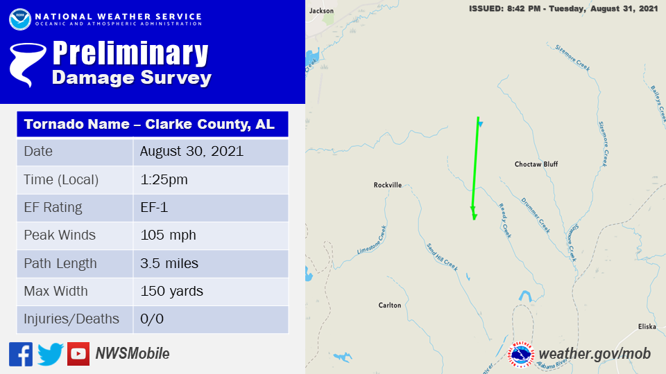
Public Information Statement
National Weather Service Mobile AL
741 PM CDT Tue Aug 31 2021
..Southern Clarke County Alabama Tornado...

Rating:                 EF1
Estimated Peak Wind:    105 mph
Path Length /statute/:  3.496 miles
Path Width /maximum/:   150.0 yards
Fatalities:             0
Injuries:               0

Start Date:             08/30/2021
Start Time:             01:25 PM CDT
Start Location:         1 NNW Choctaw Bluff / Clarke County / AL
Start Lat/Lon:          31.4064 / -87.7922

End Date:               08/30/2021
End Time:               01:28 PM CDT
End Location:           2 WSW Alma / Clarke County / AL
End Lat/Lon:            31.457 / -87.7896

Survey Summary:
The tornado likely began near Society Hill Rd south of Oregon Rd where
a mobile home was rolled and another home lost most of its roof. The tornado
continued northeast where numerous softwood snaps and uproots were noted as
the tornado crossed Society Hill Rd. The tornado then likely continued across heavily
forested areas before crossing Gainestown Rd where a couple uprooted softwoods
were noted. The tornado was likely in the dissipation process and likely dissipated
north of Gainestown Rd.

EF0...WEAK......65 TO 85 MPH
EF1...WEAK......86 TO 110 MPH
EF2...STRONG....111 TO 135 MPH
EF3...STRONG....136 TO 165 MPH
EF4...VIOLENT...166 TO 200 MPH
EF5...VIOLENT...>200 MPH


NOTE:
THE INFORMATION IN THIS STATEMENT IS PRELIMINARY AND SUBJECT TO CHANGE PENDING
FINAL REVIEW OF THE EVENTS AND PUBLICATION IN NWS STORM DATA.
The photos below were taken during the tornado survey and show the extent of the damage along the path.


Acknowledgements: Page created by Morgan Barry (Lead Forecaster).
LAST UPDATED: March 2024

