February 2021 Climate Summaries
Mobile Alabama and Pensacola Florida Area
National Weather Service Mobile Alabama
March 4, 2021
February 2021 in Review - Temperatures swung wildly during the month at Mobile and Pensacola with a notable cold spell during the middle of the month flipping to a warm spell to close out the month. A substantially, and anomalously cold airmass invaded the central Gulf coast during the middle of the month. Highs spanning a seven day period from February 13th to the 19th averaged a whopping 18.1° below normal at Mobile. The lowest high for the month at 39° on the 16th was the winner as far as departures are concerned, plummeting to 26° below normal for this date. Low temperatures spanning an eight day period from the morning of the 14th to the 21st, averaged 15.4° below normal. During this period, there were two days where new record lows were set. The lowest temperature of the month, breaking into teens at 19° on the 16th, was an astounding 25° below normal for this date. The duration of this cold event, contributed to the average monthly daytime temperature being below normal by a few degrees. At Pensacola, during the period February 13th to the 19th, highs averaged 9.5° below normal. Similar to Mobile, the lowest high at Pensacola of 39° on the 16th was 25° below normal for this date. Monthly daytime temperatures though were closer to normal. To finish out the month, even though highs and lows rebounded to well above normal at both Mobile and Pensacola, only one record high was reached during this period and that was at Pensacola on the final day of the month. Mobile and Pensacola both saw rainfall deficits comparable to each at just under 1.25" below normal for the month. The rain gauge sees substantial deficits in annual rainfall accumulations by several inches for both sites so far.
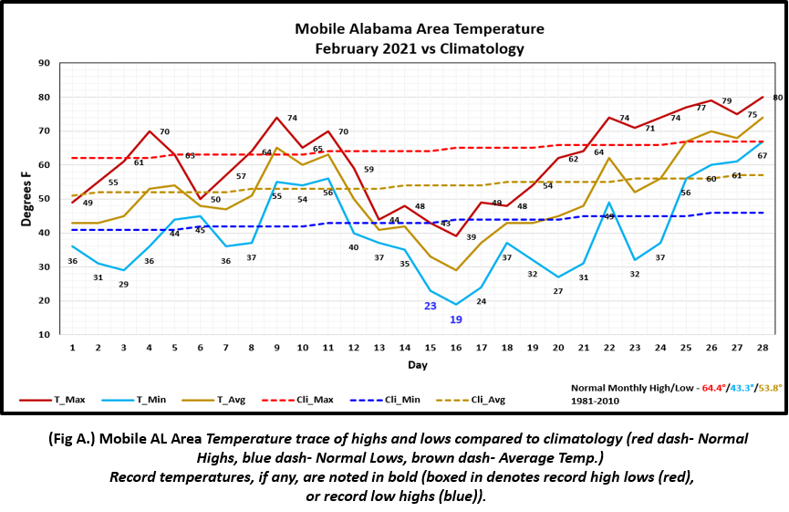
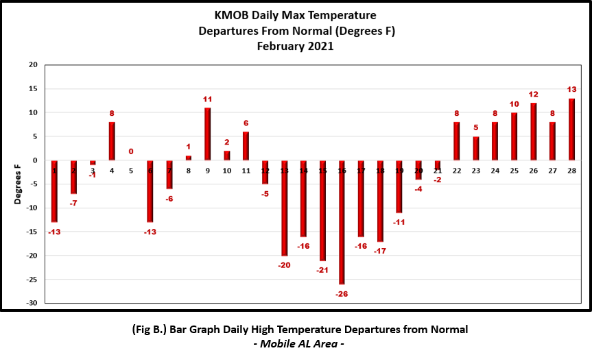
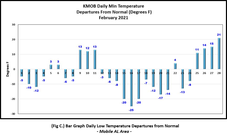
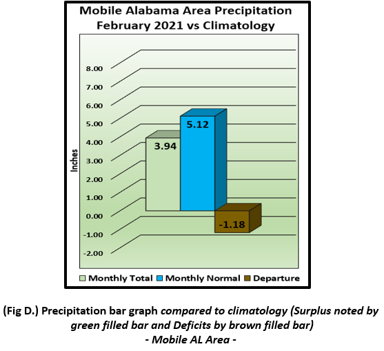
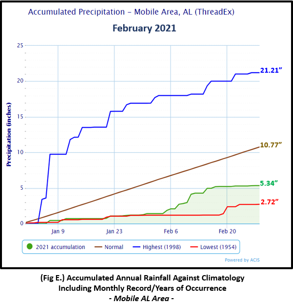
Mobile Alabama Area [Climate Normal Period 1981-2010, Climate Record Period 1872 to Present]- The average monthly high of 61.4° was 3.0° below normal. The average monthly low was 40.2° or 3.1° below normal. The average monthly temperature of 50.8° was 3.0° below normal. The highest temperature for the month, 80°, occurred on the 28th, 13° above the normal daily high temperature for this date. Two record lows were reached. 23° on the morning of the 15th broke the previous record on this date of 23° set back in 1943. The lowest temperature for the month, 19°, occurred on the morning of the 16th and broke the previous record of 22° set back in 1991. (Fig. A) shows a graphical representation of how the Mobile area temperatures compared to the seasonal normal daily highs and lows, which are shown by the colored dashed lines. New this month => the author added bar graphs showing the daily high/low temperature departures from normal shown in the table below (Figs. B and C). Total rainfall for February (Fig. D) measured only 3.94", 1.18" below normal. The annual rainfall to date shown in (Fig. E) is near 5.5" below normal.
February top records for the month during the Period of Record for the Mobile Area:
Click on the Mobile Alabama area climate graphics below to expand:
|
|
|
|
|
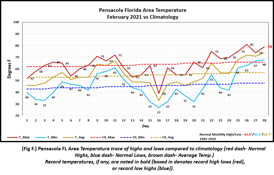
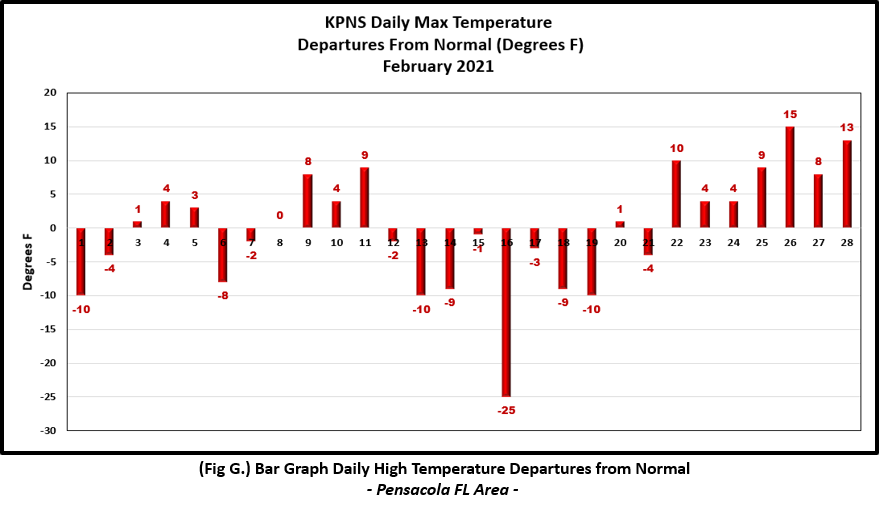
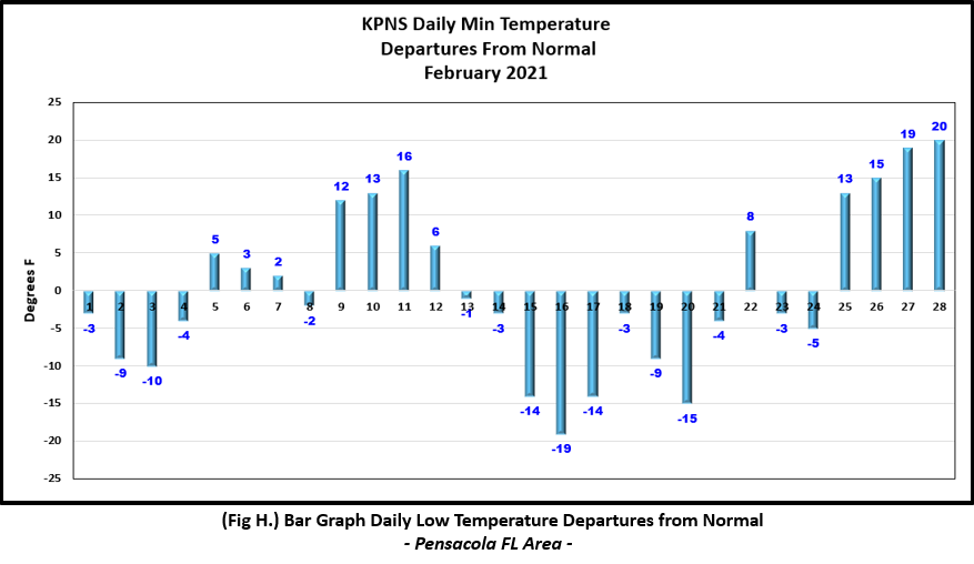
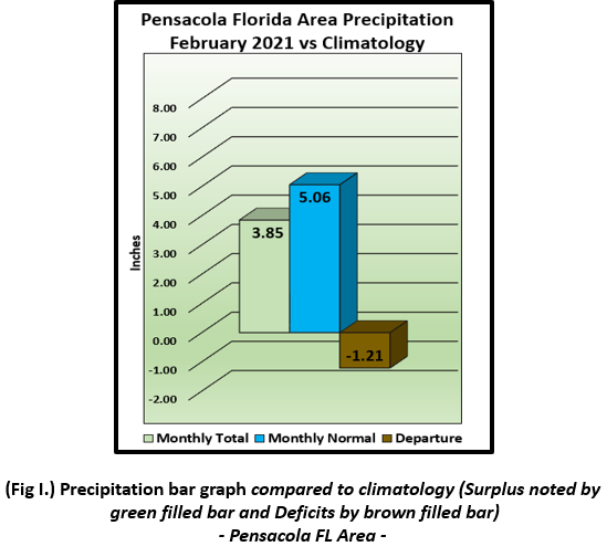
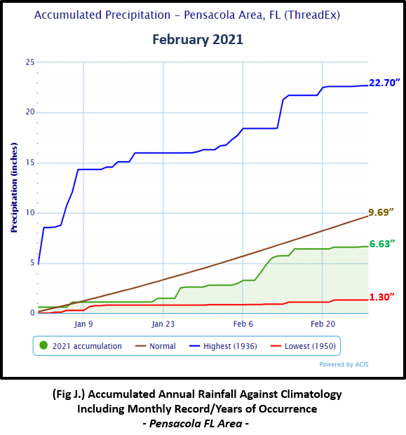
Pensacola Florida Area [Climate Normal Period 1981-2010, Climate Record Period 1879 to Present] - The average monthly high of 63.7° was 0.1° below normal. The average monthly low of 46.0° was 0.5° above normal. The average monthly temperature of 54.9° was 0.2° above normal. The highest temperature for the month was 81°, occurring on the 26th, 15° above the normal daily high temperature for this date. The lowest temperature for the month, 27°, occurred on the morning of the 16th, or 19° below the normal daily low temperature for this date. One record high was reached. 79°, occurred on the 28th breaking the previous record of 78° set on this date in 2018. (Fig. F) shows a graphical representation of how the Pensacola area temperatures compared to the seasonal normal daily highs and lows, which are shown by the colored dashed lines. (Figs. G and H) shows the daily high/low temperature departures from normal. Pensacola received 3.85" (Fig. I) of rain which was similar to the Mobile area and 1.21" below normal. The annual rainfall to date shown in (Fig. J) is near 3.0" below normal.
February top records for the month during the Period of Record for the Pensacola Area:
Click on the Pensacola Florida area climate graphics below to expand:
|
|
|
|
|
Additional February 2021 Climatology and Topics
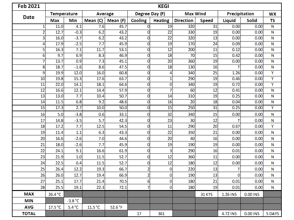
The latest February 2021 monthly summary for Eglin Air Force Base (AFB) - KVPS and Duke Field - KEGI has been received and provided in the table below. The temperatures in the daily tables are posted in °C. Data courtesy of Mr. David Biggar, Staff Meteorologist, 96th Weather Squadron. Provided by permission.

|

|
|
The National Weather Service in Mobile is looking for weather enthusiasts! We need your help in observing the weather. A great way to do this is becoming a Community Collaborative Rain, Hail, and Snow Network (CoCoRaHS) Observer. The network not only provides critical daily observations of rain, hail and yes, along the Gulf coast region, snow to aid in decision making, precipitation is also critical to the climate network. You can play a big part in this. Consider joining today! For more details click on the following link: NWS Mobile/Pensacola March 2021 CoCoRaHS Recruiting Blitz.
March 2021 Climatology, Seasonal Climatology and Outlooks:
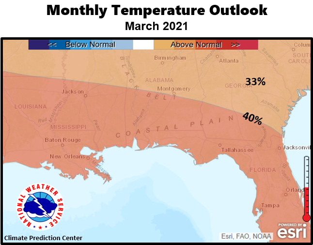
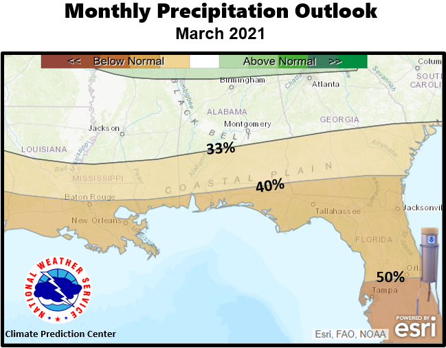
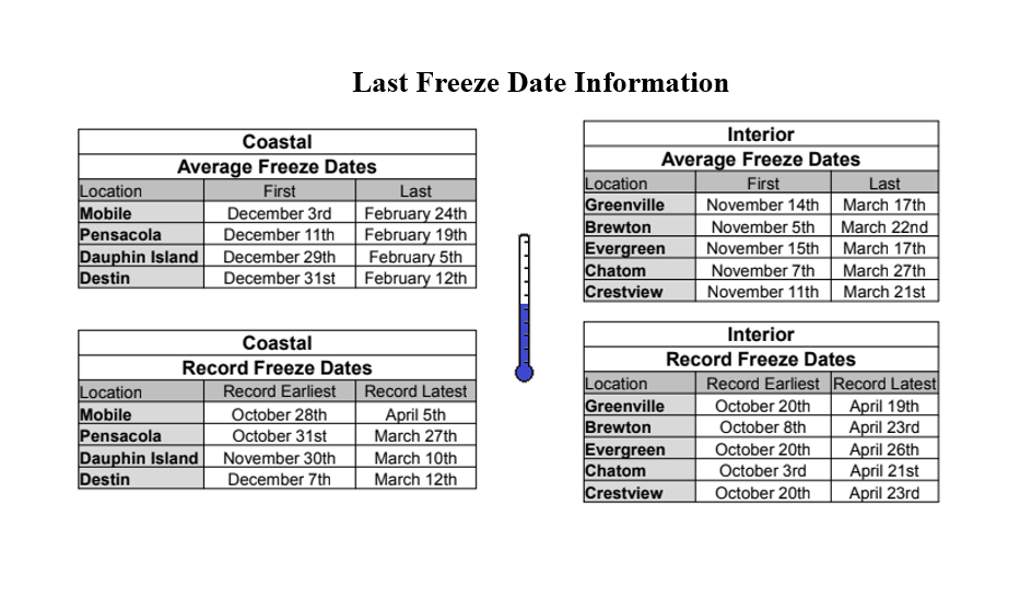
The latest outlook for monthly temperatures favors a well above normal pattern with a 33 to 50% probability over the southeast US and coastal plain. Considering this many will plan to get out into the garden and prepare for Spring planting. However, keep in mind we can still see be impacted from instances of cold weather which could see the thermometer plunging to at or below freezing which will be detrimental to sensitive outdoor plants if not protected. A link to freeze information, which includes typical last freeze date, has been added in the table below. Deficits in precipitation may continue with dryness expected over the deep south. With the growing season kicking into higher gear the next couple of months, growers and agricultural agencies will need to monitor for any evolving drought conditions closely as drought management protocols may become required. The link to the latest drought information and outlooks are included in the table below. We are moving into the height of severe weather season too and information on severe weather climatology is posted as a link.
Click on the snap shots below to expand:
|
|
Outlook |
|
|

|
Additional Climate Links:
The links below are intended to provide additional climate information, education and outlooks. The National Weather Service Mobile Alabama's Climate and Past Weather page provides climate data at your fingertips for many observation points in the local forecast area by accessing the NOWData tab as well as many other climate resources. The Climate Prediction Center Link provides short and longer range climatic outlooks and education about the larger scale global circulations that impact temperatures and weather. With the large agriculture and farming presence along the central Gulf coast, the Drought Monitor link provides updates on drought trends and impacts. Another very helpful resource is the Community Collaborative Rain Hail and Snow (CoCoRaHS) network, which is a large group of volunteers working together to measure and map precipitation (rain, hail and snow). The aim of CoCoRaHS is to provide the highest quality data for natural resource, education and research applications. You can be a part of the CoCoRaHS team by becoming a volunteer rainfall observer. To learn more click on the CoCoRaHS link below.
National Weather Service Mobile AL Climate and Past Weather
Climate Prediction Center (CPC)
CoCoRaHS Network Water Year Summaries
![]()


