December 2022 Climate Summaries
(Including Annual ReCap)
Mobile Alabama and Pensacola Florida Area
National Weather Service Mobile Alabama
January 5, 2023
December 2022 in Review - December was a month of wild temperature extremes characterized by an extended period of summer-like conditions for the first two weeks. Followed by the passage of a series of strong cold fronts, the temperature story changed markedly to one that trended much colder. The strongest of the frontal passages occurring Thursday night December 22nd brought a period of downright frigid temperatures to the deep south, just in time for Christmas. For the Mobile area, the month began anomalously warm when daily high temperatures averaged 10.0° above normal and lows averaged 14.1° above normal the first 14 days. During this span, Mobile saw five new record daily highs being broken or tied and one morning where the low tied a record high low. Entering the second half of the month the thermometer went the other direction, when daily highs averaged 9.8° below normal and lows 9.9° below normal from the 17th to the 27th. Within this period, the lows from the 23rd to the 26th alone averaged a phenomenal 20.0° below normal. For the Pensacola area, daily high temperatures averaged 8.8° above normal and lows averaged 13.4° above normal the first 14 days. During this span, Pensacola saw five new record daily highs being broken or tied and one morning where the low tied a record high low. Entering the second half of the month, colder as well where daily highs averaged 9.2° below normal and lows 10.2° below normal from the 17th to the 27th. Within this period, the lows from the 23rd to the 26th alone averaged a phenomenal 21.7° below normal at Pensacola.
Monthly rainfall at Mobile was shy of normal by a little over a half inch while Pensacola just made it above the monthly normal by nearly a quarter inch.
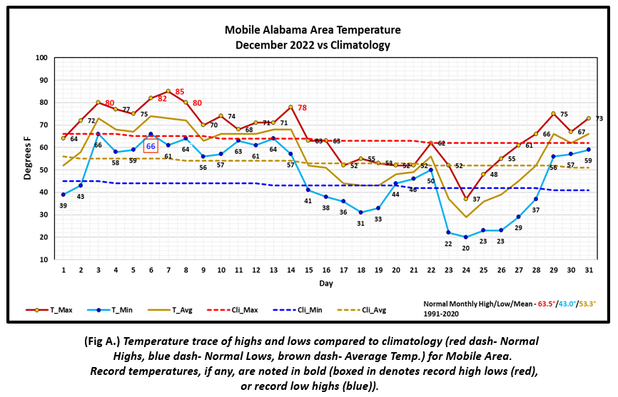
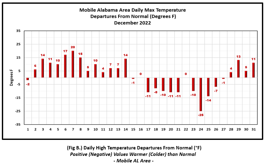
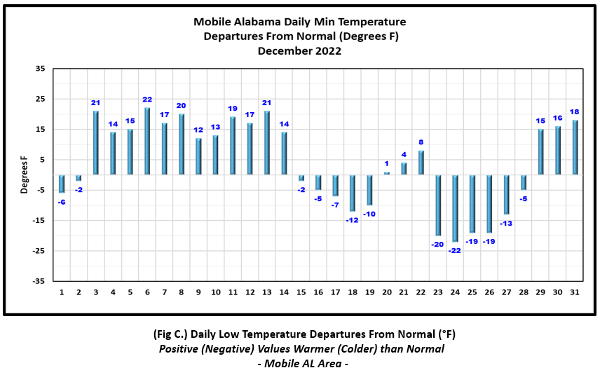
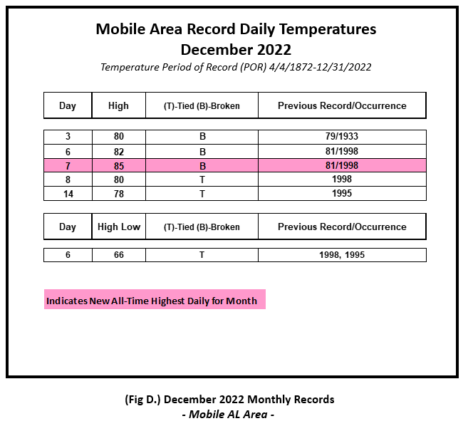
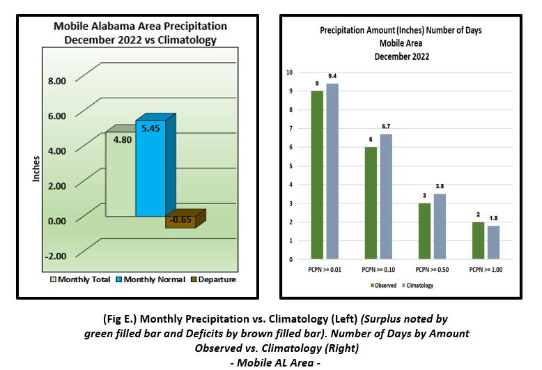
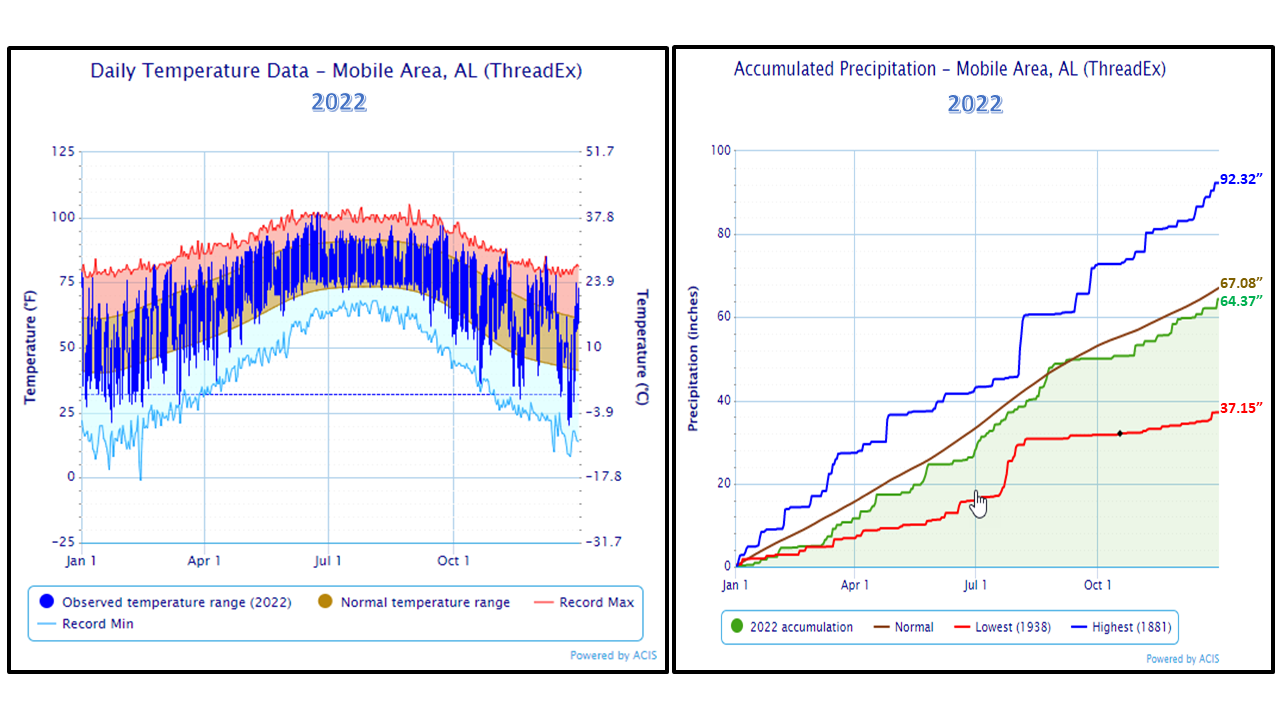
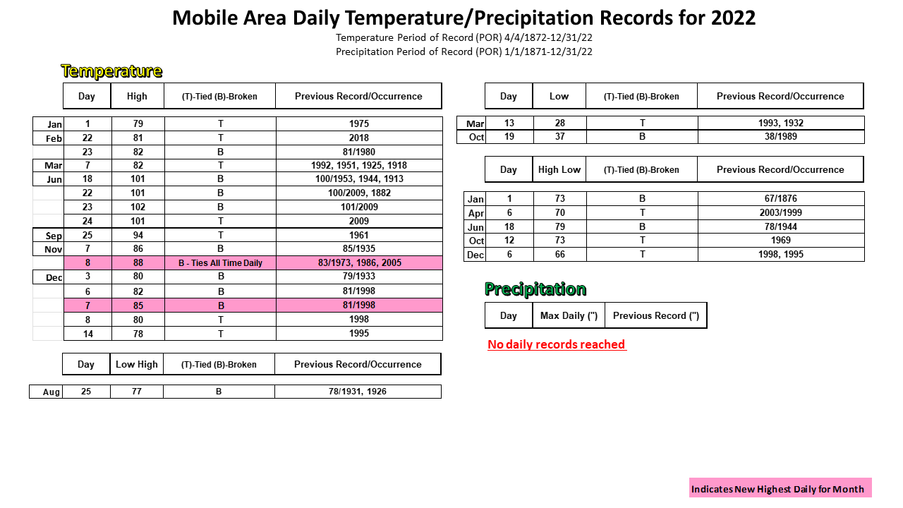
Mobile Alabama Area [Climate Normal Period 1991-2020, Climate Record Period 1872 to Present]- Despite, the arctic plunge in temperatures the start of the last quarter of the month, monthly temperatures were above normal by a few degrees due to the longer duration of well above normal temperatures the first of the month in addition to the recovery from the cold the last few days of the month. The average monthly high of 65.6° was 2.1° above normal. The average monthly low was 47.1° or 4.1° above normal. The average monthly temperature of 56.3° was 3.0° above normal. Now for the extremes. The highest temperature for the month, 85°, occurred on the 7th. This was both 20° above the normal for the date and set not only a new daily record high, but also the highest temperature in the Mobile area for the month of December. In addition, Mobile saw four other record highs being reached or tied and on the morning of the 6th, 66° tied a record high low. For the lowest temperature, Christmas Eve morning saw the thermometer plunge to 20°, an astounding 22° below normal for the date followed by the high which only reached 37°, an equally astounding 25° below normal for the date and only 5° from reaching a new daily record low high temperature for December 24th. (Fig. A) shows a graphical representation of how the Mobile area temperatures compared to the monthly normal daily highs and lows, which are shown by the colored dashed lines. Bar graphs reflecting the daily high/low temperature departures from normal are provided in (Figs. B and C). The breakout of temperature records are listed in table format (Fig. D). The rain gauge collected 4.80" (Fig. E), or 0.65" below normal.
December Top Records for the Month During the Period of Record for the Mobile Area:
Click on the Mobile Alabama area climate graphics below to expand:
|
|
|
|
|
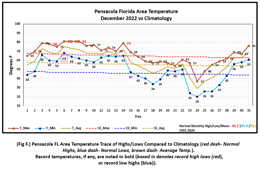
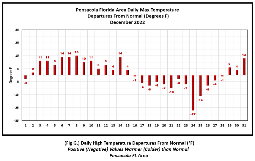
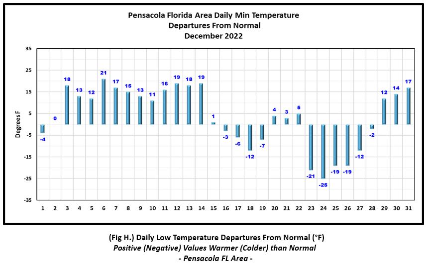
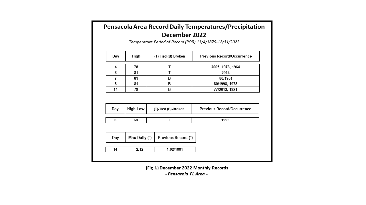
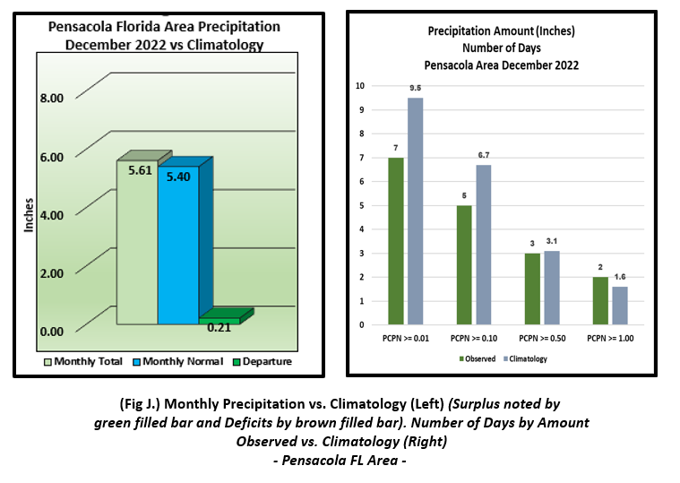
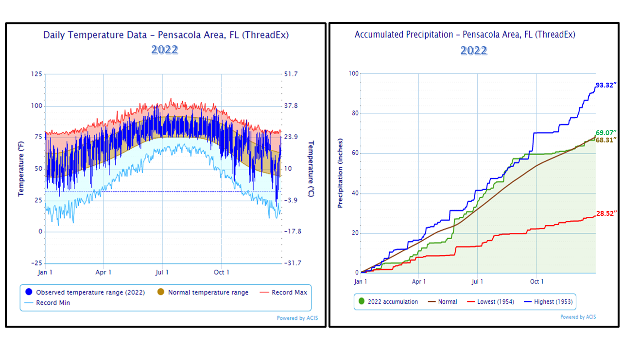
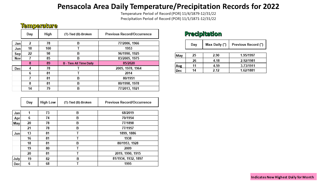
Pensacola Florida Area [Climate Normal Period 1991-2020, Climate Record Period 1879 to Present] - Despite, the arctic plunge in temperatures the start of the last quarter of the month, monthly temperatures were above normal by a few degrees due to the longer duration of well above normal temperatures the first of the month in addition to the recovery from the cold the last few days of the month. The average monthly high of 66.7° was 1.6° above normal. The average monthly low was 49.8° or 3.9° above normal. The average monthly temperature of 58.2° was 2.7° above normal. The highest temperature for the month, 81° occurring on the 6th, 7th, and the 8th averaged 14.3° above the normal for these days and also tied for the warmest temperature for the month with five other days of occurrence listed below under December's top records. In addition, two other record highs were reached and on the morning of the 6th, 68° tied a record high low. For the lowest temperature, Christmas Eve morning saw the thermometer plunge to 20°, an astounding 25° below normal for the date followed by the high which only reached 37°, an equally astounding 27° below normal for the date and only 2° shy of reaching a new daily record low high temperature for December 24th. (Fig. F) shows a graphical representation of how the Pensacola area temperatures compared to the seasonal normal daily highs and lows, which are shown by the colored dashed lines. (Figs. G and H) shows the daily high/low temperature departures from normal. The breakout of temperature and precipitation records is listed in table format below (Fig. I). The rain gauge collected 5.61" (Fig. J), or 0.21" above normal for the month. Of the total monthly rainfall, 38% or 2.12" falling on the 14th set a new one day record rainfall.
December Top Records for the Month During the Period of Record for the Pensacola Area:
Click on the Pensacola Florida area climate graphics below to expand:
|
|
|
|
|
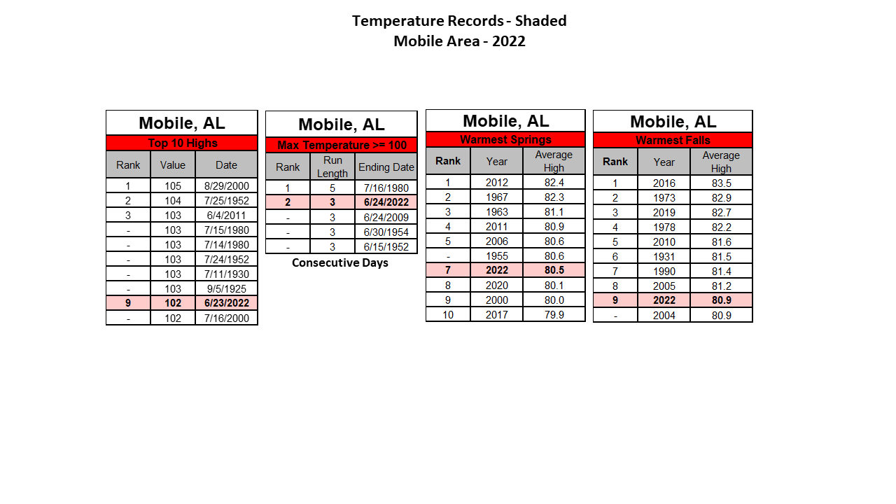
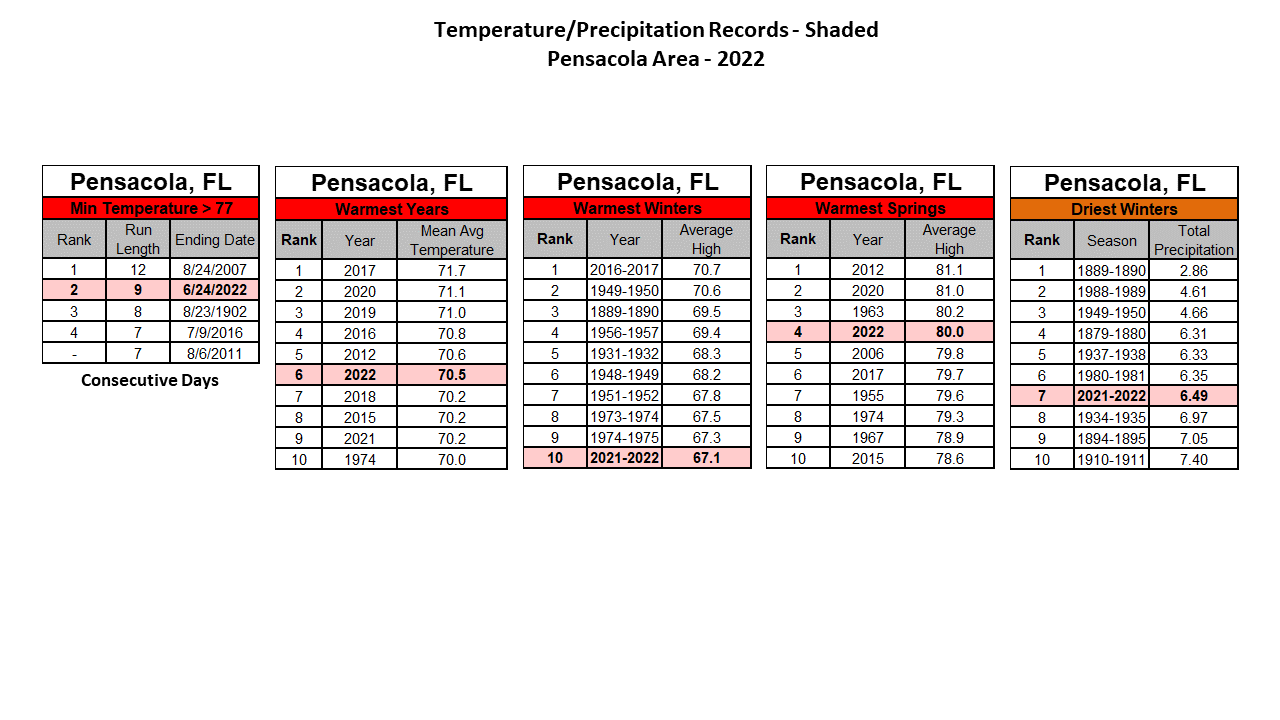
2022 (A Recap) - Mobile saw 24 total days of record temperatures. Of the records, 16 were record highs, one was a record low high, two were record lows and five were record high lows. December saw the most record high temperatures at five for the month. The high on November 8th of 88° smashed the previous record of 83° that day and also tied with the other all time highest daily temperature for the month of November occurring on November 4th, 2016. December 7th, the high of 85° surged past the previous recorded record high of 81° and also stands alone as the warmest daily high for the month of December. The hottest day of the year at Mobile was June 23rd, when the thermometer rose to a sizzling 102°, breaking into the top 10 hottest days on record at number 9. Mobile also saw three straight days ending June 24th where highs exceeded 100°, coming in second place in a streak of days seeing daily temperatures at or above 100°. Pensacola recorded 21 days of record temperatures. Of these records, 10 were record highs and 11 were record high lows. Surprisingly, no record lows or low highs were reached. The average annual temperature at Pensacola at 70.5° stands as the 6th warmest year on record for Pensacola. Interestingly, the top 9 warmest years for annual average temperatures at Pensacola, including this year, have occurred over the last decade. It was a warm Spring in Pensacola which broke into the top 5 warmest Springs on record with an average high temperature of 80° placing 4th warmest.
As far as precipitation is concerned, Mobile experienced a deficit in rainfall. The annual total of 64.37" was 2.71" below normal. The wettest month was August with gauge collection of 11.08" or 4.21" above normal for the month. The following month, the spigot ran dry with September being the driest month of the year when only 1.22" was collected in the rain gauge or 4.08" below normal for the month. The Mobile area also dealt with periods of moderate to at times severe drought conditions from October to late November. The wettest month in Pensacola was May with gauge collection of 12.05" or 8.15" above normal for the month. Following a wet summer when over 30" of rain fell in Pensacola, an extended dry period followed for September through November. The driest month in 2022 at Pensacola was October when only 1.15" made it into the rain gauge or 3.48" below normal for the month. The Pensacola area also dealt with an extended period of moderate to severe drought conditions from the middle of October Through December. The daily temperature and precipitation records, their dates of occurrence and whether they were broken or tied are provided at the end of the table below. A detailed listing of annual, monthly, and seasonal records are also provided below in table format.
2022 Temperature/ Precipitation and Records:
|
|
|
|
|
|
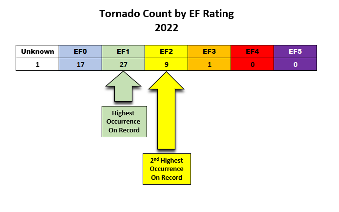
2022 Severe Weather: NWS Mobile storm survey teams verified the occurrence of a record setting 55 tornadoes impacting the National Weather Service (NWS) Mobile County Warning Area (CWA). This number stands alone as the most confirmed tornadoes in a single year since official storm event records have been kept since 1950. The previous record of tornadoes in a single year was 39 tornadoes back in 2011. The image below shows the number of occurrences of tornadoes in 2022 sorted by (Enhanced Fujita Scale (EF) Rating. The verified number of EF1's and EF2's also stand tall in the record books. Note: There was one event that was classified as unknown given the overlapping paths and likely similar starting points with another verified tornado occurring in eastern Crenshaw county on April 5th. It was impossible to determine what the true intensity, path width, path length, and end point of this tornado was.
Details of each survey are provided in the Past Significant Weather Events link.

Additional December 2022 Climatology and Topics
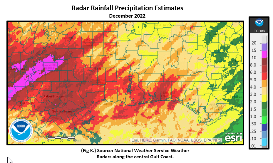
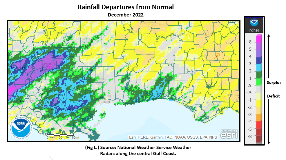
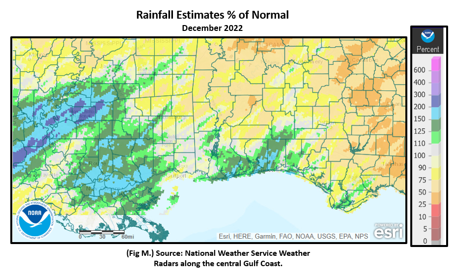
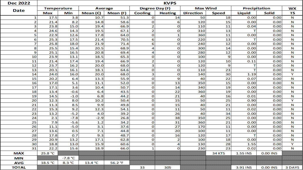
The bulk of the rain through the month of December was observed in a narrow swath from southern Mississippi to coastal southwest Alabama into the western Florida Panhandle. Highest rainfall departures to above normal were focused over coastal Baldwin county in Alabama and the southern portions of the western Florida Panhandle where between 110 to 150% of normal rainfall was distributed. Fig. K shows the areal monthly rainfall total, Fig. L shows the areal rainfall departures from normal and Fig. M, the areal percent of normal rainfall. The latest December 2022 monthly summary for Eglin Air Force Base (AFB) - KVPS and Duke Field - KEGI has been received and provided in the table below. The temperatures in the daily tables consists of numbers both in °F/°C. Data courtesy of Mr. David Biggar, Staff Meteorologist, 96th Weather Squadron. Provided by permission.
|
|
|

|
|

|
January 2023 Climatology, Seasonal Climatology and Outlooks:
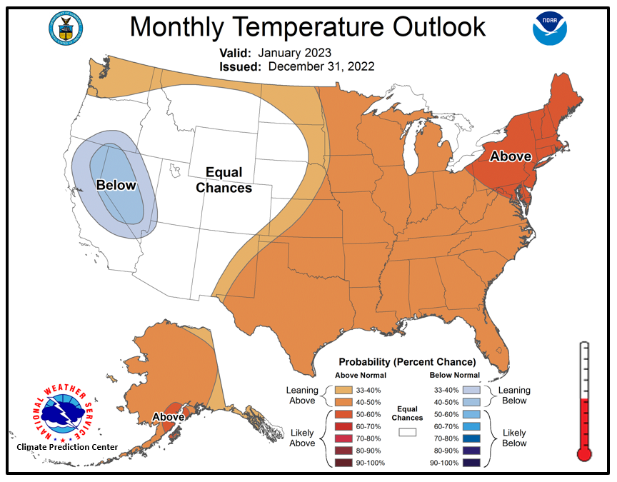
The latest outlook for January presents a pattern that favors temperatures leaning above normal over the central and southeast US and equal chances of above or below normal precipitation over the Coastal Plain.
Click on the snap shots below to expand:
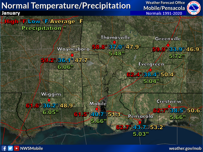 January Normals January Normals |
|
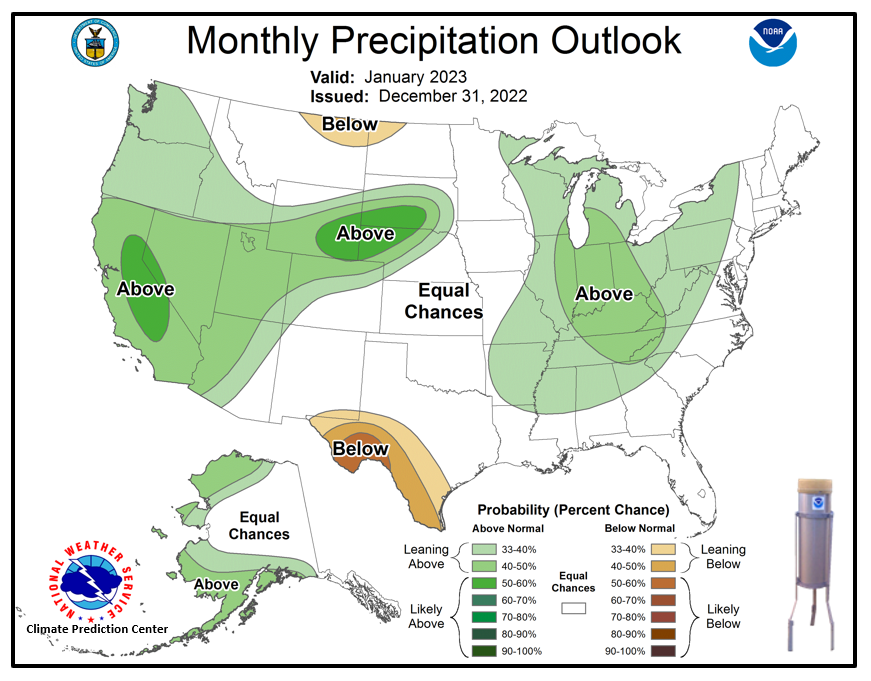
Outlook |
|
Additional Climate Links:
The links below are intended to provide additional climate information, education and outlooks. The National Weather Service Mobile Alabama's Climate and Past Weather page provides climate data at your fingertips for many observation points in the local forecast area by accessing the NOWData tab as well as many other climate resources. The Climate Prediction Center Link provides short and longer range climatic outlooks and education about the larger scale global circulations that impact temperatures and weather. With the large agriculture and farming presence along the central Gulf coast, the Drought Monitor link provides updates on drought trends and impacts. Another very helpful resource is the Community Collaborative Rain Hail and Snow (CoCoRaHS) network, which is a large group of volunteers working together to measure and map precipitation (rain, hail and snow). The aim of CoCoRaHS is to provide the highest quality data for natural resource, education and research applications. You can be a part of the CoCoRaHS team by becoming a volunteer rainfall observer. To learn more click on the CoCoRaHS link below.
National Weather Service Mobile AL Climate and Past Weather
Climate Prediction Center (CPC)
CoCoRaHS Network Water Year Summaries