December 2020 Climate Summaries
Mobile Alabama and Pensacola Florida Area
National Weather Service Mobile Alabama
January 8, 2021
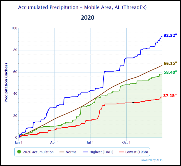
December 2020 in Review - A few lengthy spells of well above normal high temperatures were observed. A couple of notable warm spikes were experienced during the middle and close of the month at Mobile and Pensacola. Even so, a brief cold surge made it feel more like Christmas this year than in recent years when Gulf coast residents saw warm conditions. Average temperatures Christmas day ranged from 11 to 13 degrees below normal. A couple more days of much below normal low temperatures followed, then a substantial warm spell by New Year's Eve when average temperatures peaked to around 17 degrees above normal. Despite the wild swings in temperatures, no record highs or lows were observed. December's average temperatures were about a degree below normal at Mobile and about a degree above at Pensacola. There was one daily record rainfall observed and that was in Mobile on Christmas Eve, but the story remains the same for the month when precipitation continued to lack overall at Mobile by nearly a half inch off the monthly December normal. On the flip side, Pensacola received a surplus, but only slightly by about a quarter inch above normal. Mobile finished the year with a large annual deficit in rainfall by several inches. Pensacola accumulated a substantial surplus in annual rainfall, just shy of a foot.
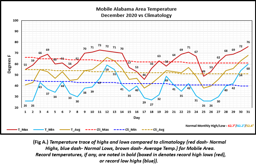
Mobile Alabama Area [Climate Normal Period 1981-2010, Climate Record Period 1872 to Present]- The average monthly high of 63.5° was 0.8° above normal. The average monthly low was 38.4° or 3.8° below normal. The average monthly temperature of 50.9° was 1.5° below normal. The highest temperature for the month, 76°, occurred on New Year's Eve. The lowest temperature for the month, 26°, occurred four times during the month on the 1st, 2nd, Christmas day morning and again the following morning on the 26th. (Fig. A) shows a graphical representation of how the Mobile area temperatures compared to the seasonal normal monthly highs and lows, which are shown by the colored dashed lines. Total rainfall for December (Fig. B) measured 4.61", 0.45" below normal.
December top records for the month during the Period of Record for the Mobile Area:
Click on the Mobile Alabama area climate graphics below to expand:
|

|
Pensacola Florida Area [Climate Normal Period 1981-2010, Climate Record Period 1879 to Present] - The average monthly high of 64.8° was 2.2° above normal. The average monthly low of 43.4° was 1.0° below normal. The average monthly temperature of 54.1° was 0.6° above normal. The highest temperature for the month was 78°, occurring on the 12th. The lowest temperature for the month, 29°, occurred on the morning of the 26th. (Fig. C) shows a graphical representation of how the Pensacola area temperatures compared to the seasonal normal monthly highs and lows, which are shown by the colored dashed lines. The rain gauge measured 4.76" (Fig. D) which was 0.21 inches above normal.
December top records for the month during the Period of Record for the Pensacola Area:
Click on the Pensacola Florida area climate graphics below to expand:

|

|
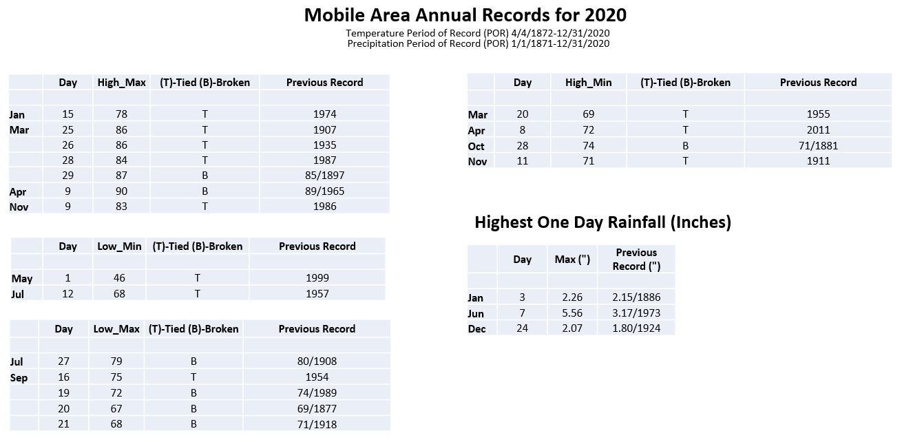
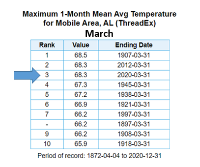
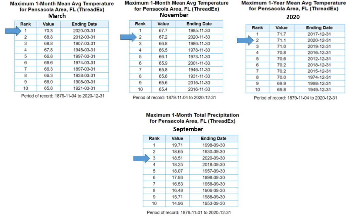
2020 (A Recap) - Mobile saw 18 days of record temperatures, the majority of which were record highs and record low maximums. Meanwhile to the east at Pensacola, the number of days record temperatures were observed added up to 31. In fact, the average annual temperature at Pensacola, 71.1°, came in at second warmest for the period of record dating back to November 1879. Interestingly, the top seven warmest years for annual average temperatures at Pensacola have occurred over the last decade. March was the top warmest on record at Pensacola and November was 2nd warmest. On the morning of March 28th, a low temperature of only 73° at Pensacola set a new all time highest monthly minimum temperature for the month. The average monthly temperature of 68.3° for March at Mobile ranked 3rd warmest. Three days of record breaking one day excessive rainfalls occurred in Mobile and four days in Pensacola. The most notable one-day rainfall extreme for the year came in just shy of 12" at Pensacola during the middle of September. This accumulated amount was associated with the slow northward motion of Hurricane Sally which helped propel Pensacola's September monthly rainfall total to 18.51" or 3rd wettest Septembers during the period of record dating back to November 1879. The break-out of the annual temperature/precipitation graphs and local records for the Mobile and Pensacola area is provided below.
2020 Temperature/ Precipitation Traces and Tabular Record Breakout:

|
|

|

|
|

|
|
|
2020 Severe Weather *: A total of 26 tornadoes impacted the National Weather Service (NWS) Mobile County Warning Area (CWA). Of these 26, 1 occurred in February, 1 occurred in March, 18 occurred in April, 5 occurred in June, and 1 in October. Here is a breakout of the 26 by Enhanced Fujita Scale (EF) Rating:
EF0 - 6
EF1- 19
EF2- 1
2020 was record breaking with tornado occurrence. NWS Mobile storm survey teams verified the occurrence of 7 tornadoes in Mobile county, AL. This set an annual record for the county. The previous record was 6 tornadoes back in 1980. Elsewhere in the CWA, 7 tornadoes were verified touching down in George county, MS which smashes the old annual record for the county of 3 back in 1971. (All tornado records go back to 1950.)
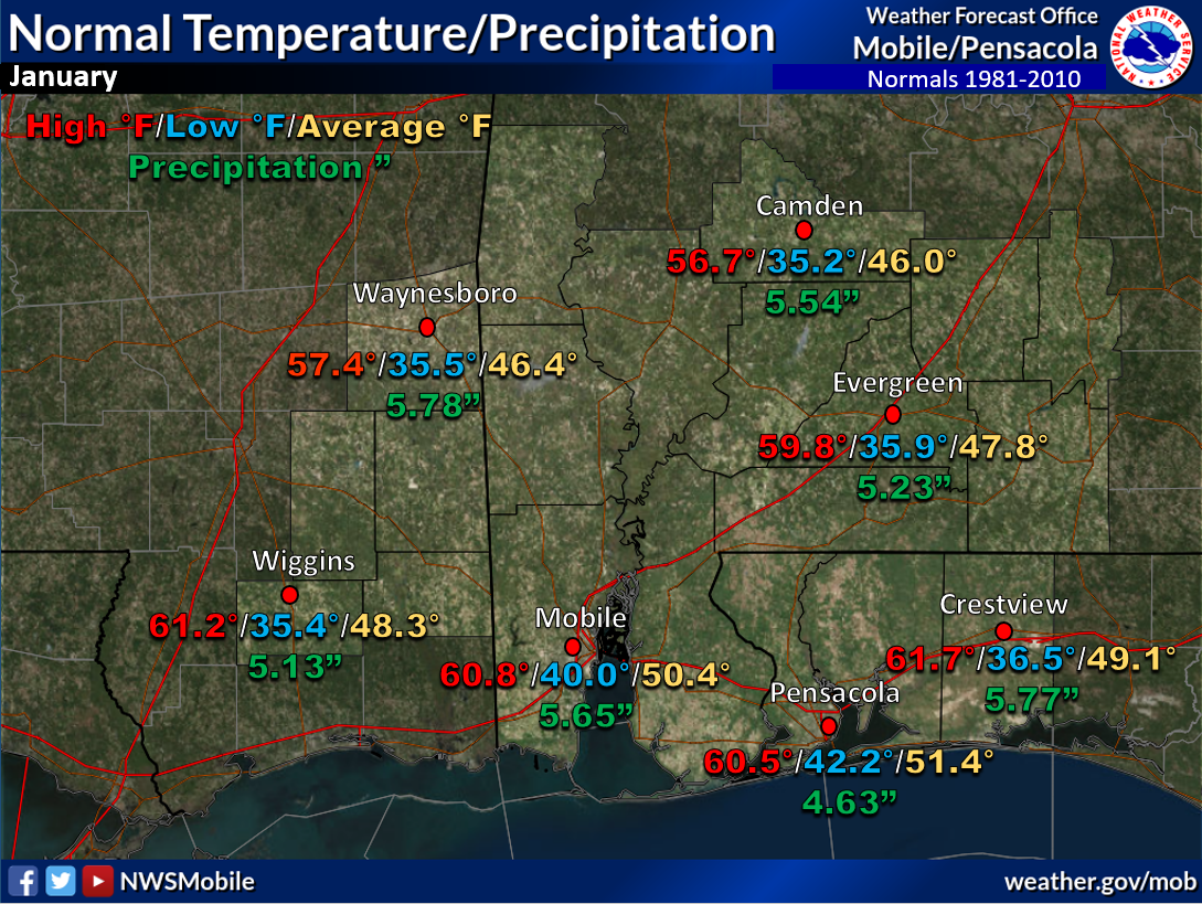
January Climatology and Outlooks:
The long range weather pattern favors above normal temperatures and precipitation over the deep south during the month of January. Some expansion of developing drought possible over the southeast the first quarter of 2021.
Click on the snap shots below to expand:
|

Outlook |

Outlook |

|
Climate Prediction Center's Interactive Long Range Outlooks
Additional Climate Links:
The links below are intended to provide additional climate information, education and outlooks. The National Weather Service Mobile Alabama's Climate and Past Weather page provides climate data at your fingertips for many observation points in the local forecast area by accessing the NOWData tab as well as many other climate resources. The Climate Prediction Center Link provides short and longer range climatic outlooks and education about the larger scale global circulations that impact temperatures and weather. With the large agriculture and farming presence along the central Gulf coast, the Drought Monitor link provides updates on drought trends and impacts. Another very helpful resource is the Community Collaborative Rain Hail and Snow (CoCoRaHS) network, which is a large group of volunteers working together to measure and map precipitation (rain, hail and snow). The aim of CoCoRaHS is to provide the highest quality data for natural resource, education and research applications. You can be a part of the CoCoRaHS team by becoming a volunteer rainfall observer. To learn more click on the CoCoRaHS link below.
National Weather Service Mobile AL Climate and Past Weather
Climate Prediction Center (CPC)
CoCoRaHS Network Water Year Summaries


