August 2024 Climate Summaries
Mobile Alabama and Pensacola Florida Area
Joe Maniscalco - Observation Program Leader (OPL)/Meteorologist
POC for Observation, Climate, and COOP
National Weather Service Mobile Alabama
September 4, 2024
August 2024 in Review - For the second consecutive year, the month of August in Mobile was another record setting hot month coming in at second warmest for average monthly highs and average temperatures, right behind August 2023 which was top warmest August in the period of record. The 1st to the 29th of the month saw highs at or well above normal. Outside of only four days, lows were at or above normal for the month. Interestingly though, only one daily record high and one morning high low temperature was reached for the Mobile area. The elevated average temperatures was attributed to an astounding 23 days of 95°and higher, way above typical normal of 4 days of occurrence. At Pensacola, the average high, low and monthly means were close to August normals.
The other extreme was the lack of rainfall at both Mobile and Pensacola, at well below monthly normal. Mobile's 2.24" tied for 9th driest August on record and Pensacola, recording just a hair less than one inch, stands as the 3rd driest August. Considering the dryness and the heat, antecedent soil moisture decreased substantially leading to a re-emergence of moderate drought by the end of the month.
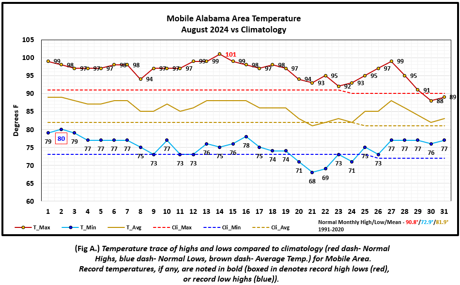
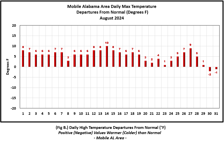
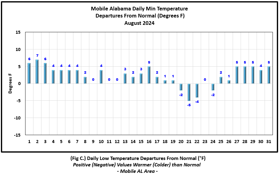
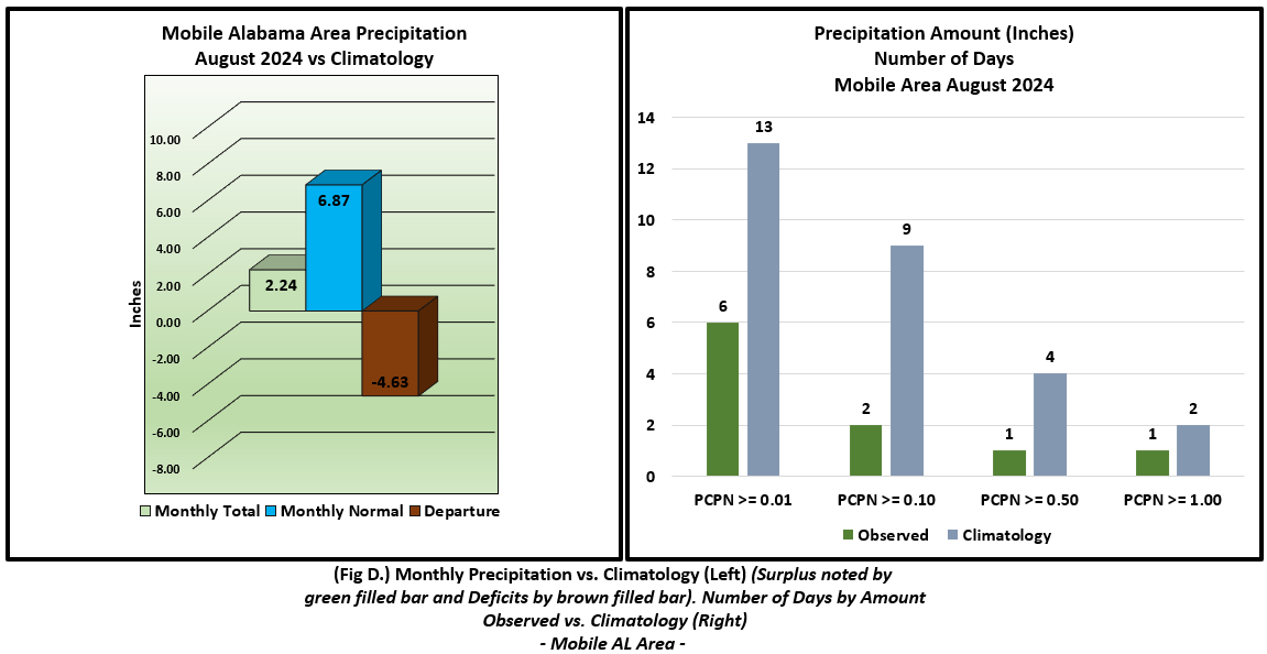
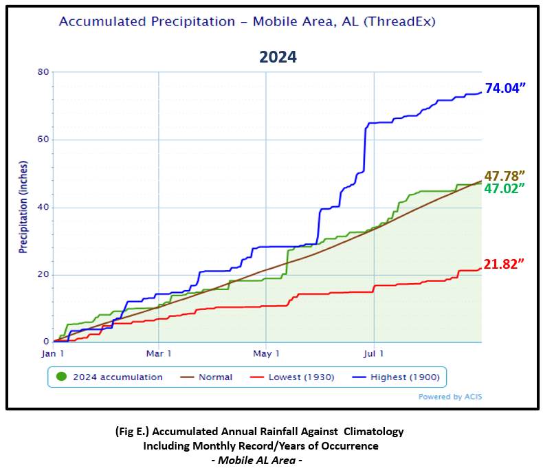
Mobile Alabama Area [Climate Normal Period 1991-2020, Climate Record Period 1872 to Present]- The average monthly high of 96.1° was 5.3° above normal and overtakes 2011's average of 95.6° to now stand as the second warmest average monthly high on record. The average monthly low of 75.1° was 2.2° above normal. The average temperature was 85.6°, 3.7° above normal and stands as second warmest August's on record for the monthly mean. The highest temperature for the month eased above the century mark on the 14th at 101°, 10° above the normal for this date and also set a new daily record high, surpassing the previous record of 99° set in 2023 and 1999. A record high low temperature of 80°, occurring on the morning of the 2nd, edged above the previous record of 79° set in 2010, 1947, 1937, 1915, and 1883. Following, an atypical passage of a strong late August cool front, the lowest temperature for the month, settled to 68° on the morning of the 21st, 5° below normal for the date. (Fig. A) shows a graphical representation of how the Mobile area temperatures compared to the seasonal normal daily highs and lows, which are shown by the colored dashed lines. Bar graphs reflecting the daily high/low temperature departures from normal are provided in the table below (Figs. B and C). The rain gauge caught a meager 2.24" (Fig. D), 4.63 " below the monthly normal. August 2024 for Mobile ties for the 9th driest Augusts on record along side the same amount in 1940. (Fig. E) shows the annual accumulated precipitation. Despite the limited amount of monthly rainfall, the Mobile area is only shy of annual normal by 0.76".
August top records for the month during the Period of Record for the Mobile Area:
Click on the Mobile Alabama area climate graphics below to expand:
|
|
|
|
|
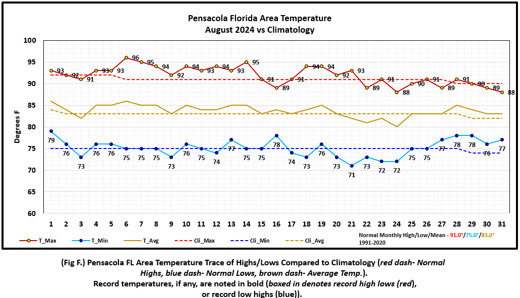
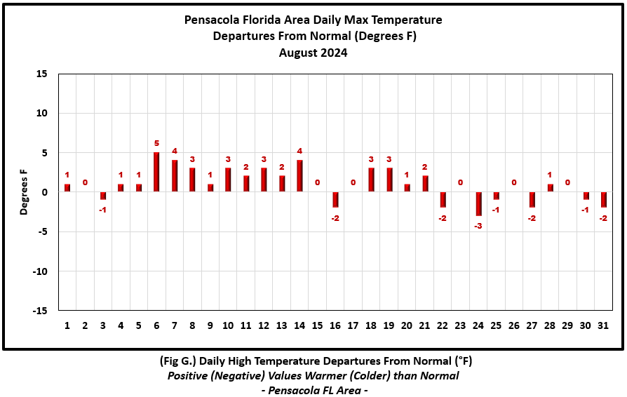
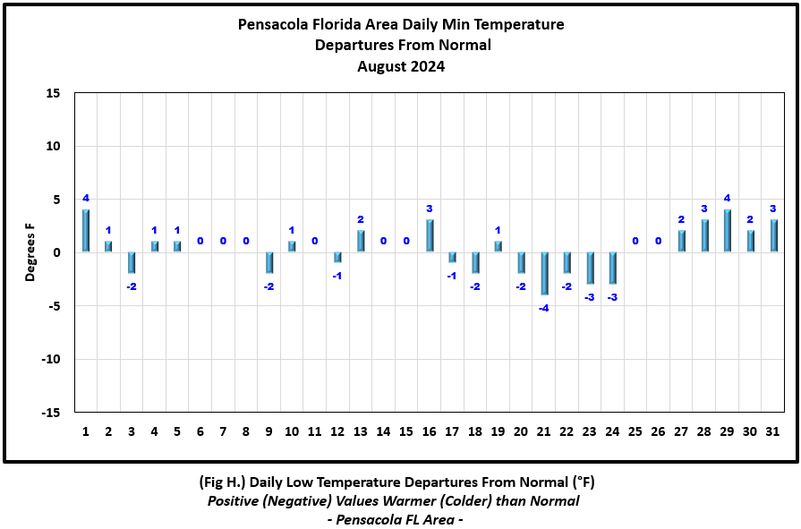
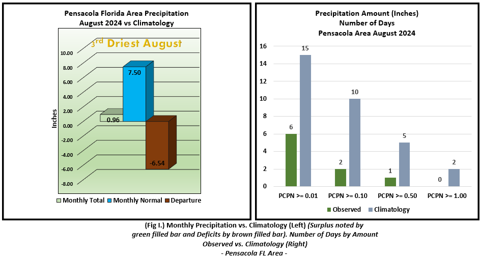
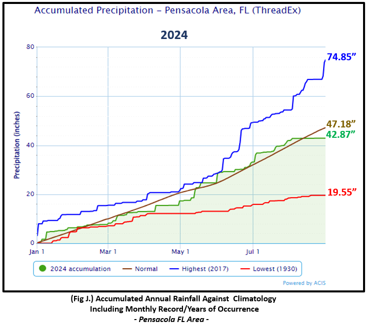
Pensacola Florida Area [Climate Normal Period 1991-2020, Climate Record Period 1879 to Present] - The average monthly high of 91.9° was 0.9° above normal. The average monthly low of 75.1° was 0.1° above normal. The average temperature of 83.5° was 0.5° above normal. The highest temperature for the month rose to 96° on the 6th and was 5° above the normal for the date. The lowest temperature for the month, 71° on the morning of the 21st, was 4° below normal for this date. No record temperatures were reached at Pensacola. (Fig. F) shows a graphical representation of how the Pensacola area temperatures compared to the seasonal normal daily highs and lows, which are shown by the colored dashed lines. (Figs. G and H) shows the daily high/low temperature departures from normal. Rain was in short supply at Pensacola, with the gauge only recording 0.96" (Fig. I), 6.54 " below the monthly normal. August 2024 at Pensacola stands at 3rd Driest August's on record. (Fig. J) shows the annual accumulated precipitation. The Pensacola area is in deficit to date by 4.31" below normal.
August top records for the month during the Period of Record for the Pensacola Area:
Click on the Pensacola Florida area climate graphics below to expand:
|
|
|
|
|
Additional August 2024 Climatology and Topics
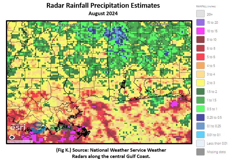
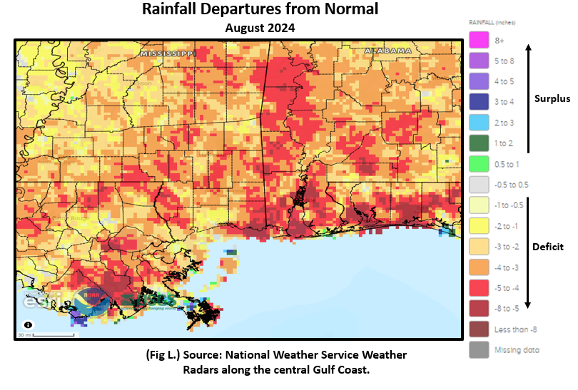
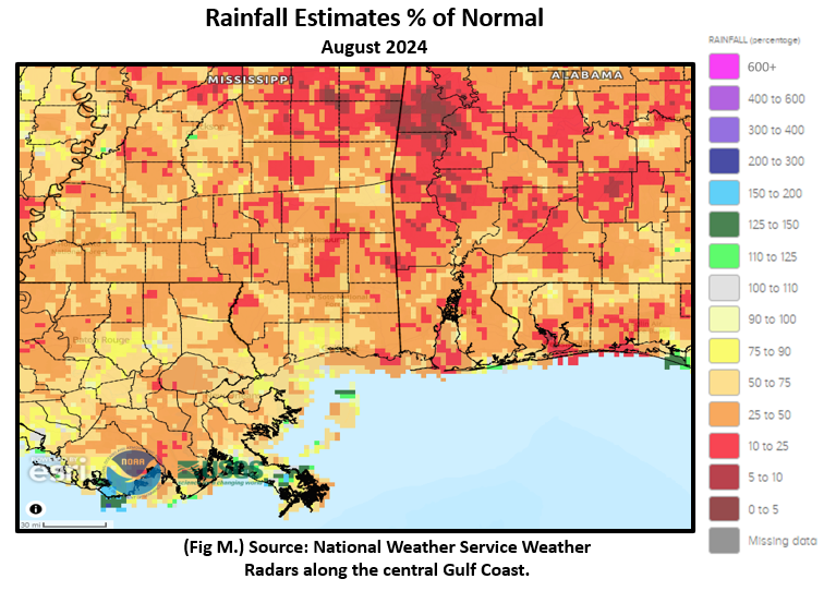
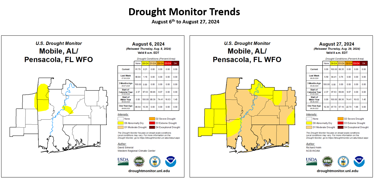
The spigot ran dry for the month of August over the central Gulf coast showing most of the local area ranging 10 to 50% of normal rainfall. In fact, there were some areas that reflected much worse at receiving less than 5% of normal rainfall. (Fig. K) shows the areal distribution of monthly rainfall, (Fig. L) shows the areal rainfall departures from normal and (Fig. M). Dry conditions have resulted in the redevelopment of drought shown in (Fig. N). Here are some notable rainfall reports, via local NWS Mobile/Pensacola COOP observers, that indicate August 2024 as being the driest on record:
The largest August deficit in rainfall locally is the COOP station in Niceville at 7.82" below normal.
The latest August 2024 Monthly Climate Summary for Eglin Air Force Base (KVPS) and Duke Field (KEGI) has been provided courtesy of Mr. David Biggar, Staff Meteorologist, 96th Weather Squadron. Provided by permission.
|
|
|
|
September 2024 Climatology, Seasonal Climatology and Outlooks:
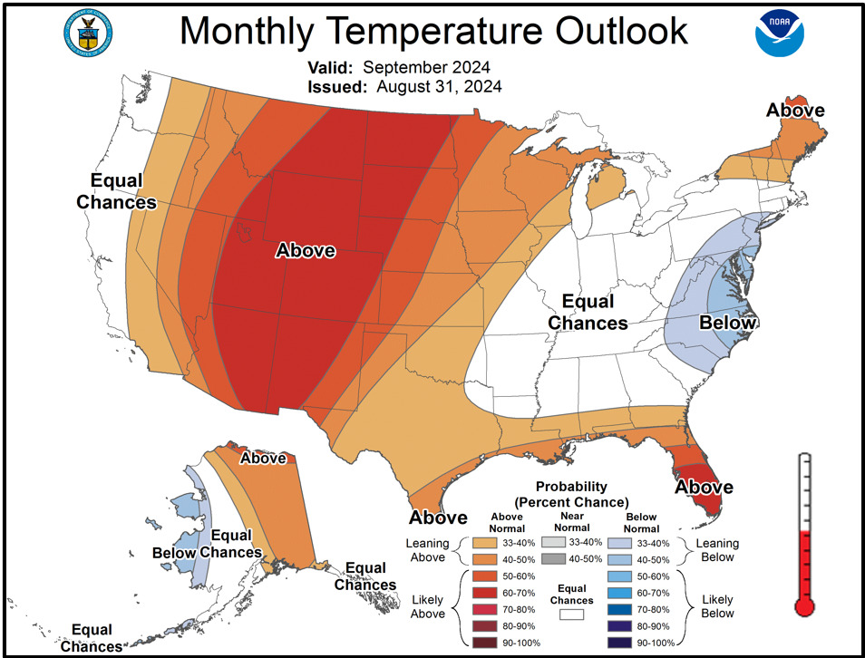
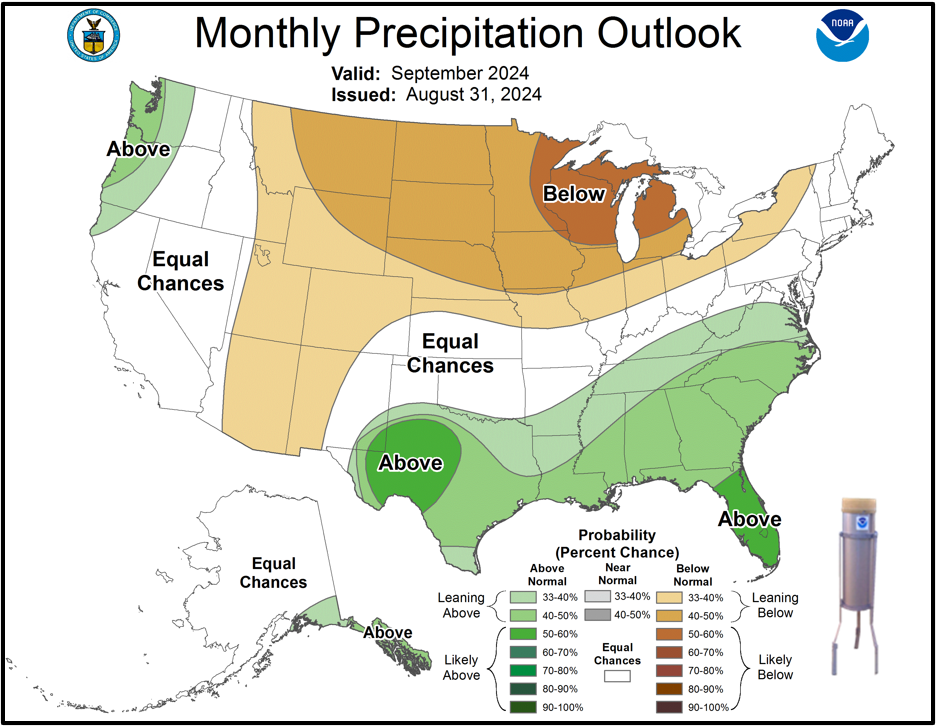
Looking ahead to September, temperatures and precipitation are favored to lean above normal over the central Gulf coast. We continue in the climatological peak of hurricane season. NOAA updated its Atlantic Basin Hurricane outlook for tropical activity earlier in August which continues to indicate above normal activity. As we continue through the peak months of the Atlantic Basin Hurricane Season, it's highly encouraged to review your hurricane preparedness. Click on the Preparedness Tab on the NWS Mobile Tropical Webpage. Lastly, due to the persistently dry conditions, a drought link has been added below to monitor trends.
Click on the snap shots below to expand:
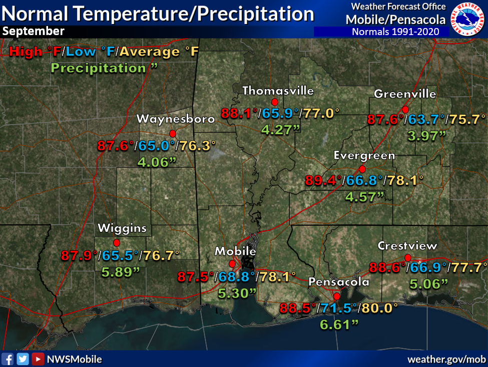 September Normals September Normals |
|
Outlook |
|

|
|

|

|
Additional Climate Links:
The National Weather Service Mobile Alabama's Climate and Past Weather page provides climate data at your fingertips for many observation points in the local forecast area by accessing the NOWData tab as well as many other climate resources. The Climate Prediction Center Link provides short and longer range climatic outlooks and education about the larger scale global circulations that impact temperatures and weather. With the large agriculture and farming presence along the central Gulf coast, the Drought Monitor link provides updates on drought trends and impacts. Another very helpful resource is the Community Collaborative Rain Hail and Snow (CoCoRaHS) network, which is a large group of volunteers working together to measure and map precipitation (rain, hail, and snow). The aim of CoCoRaHS is to provide the highest quality data for natural resource, education and research applications. You can be a part of the CoCoRaHS team by becoming a volunteer rainfall observer.
Questions or Comments:
Contact: Joe Maniscalco - Observation Program Leader WFO Mobile, AL at joe.maniscalco@noaa.gov


