April 2020 Climate Summaries
Mobile Alabama and Pensacola Florida Area
National Weather Service Mobile Alabama
May 4, 2020
April 2020 in Review - Temperatures started to show a gradual upward movement, in line with seasonal normal comparisons. This month, low temperatures showed more wildly variable swings of short daily duration at Mobile and to a lesser extent Pensacola. April turned out to be very close to seasonal normals at Mobile overall while Pensacola averaged about 3 to 4° above normal in temperatures. One record high low temperature was observed in Mobile and two were observed on subsequent mornings at Pensacola. Regarding other records, one day produced a new record high at Mobile and at Pensacola, the two mornings that resulted in record high lows observed new daily record highs as well. Little rain occurred at the Mobile area, with monthly totals coming in over an inch below what we normally expect to see in April. To the east, the rain gauge reported much closer to normal rain amounts at Pensacola. Due to a lengthy period of dry weather and the rainfall deficits that are adding up, moderate to severe drought is in place over portions of the Gulf coast.
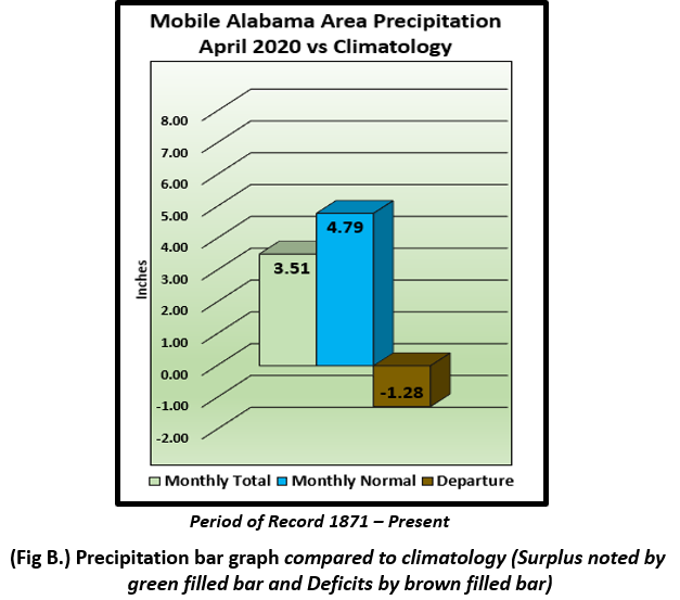
Mobile Alabama Area - The average monthly high of 79.1° was 1.6° above normal. The average monthly low was 55.5° or 0.1° above normal. The average monthly temperature of 67.3° was 0.9° above normal. (Fig. A) shows a graphical representation of how the Mobile area temperatures compared to the seasonal normal monthly highs and lows, which are shown by the colored dashed lines. There were two record temperatures reached for the Mobile area. One was a record high low temperature of 72° occurring on the morning of the 8th which tied the previous record from 2011. On the following day, a record high of 90° occurring on the 9th which broke the previous record of 89° set back in 1965. Total rainfall for April (Fig. B) measured 3.51" or 1.28" below normal. A precipitation trace for the Mobile area since January 1st is provided in the graphics below showing how it compares to normal year to date totals. The Mobile area annual rainfall lags well behind normal by well over seven inches which has contributed to the onset of moderate to severe drought conditions over Mobile county.
Click on the Mobile Alabama area climate graphics below to expand:

|
|

|
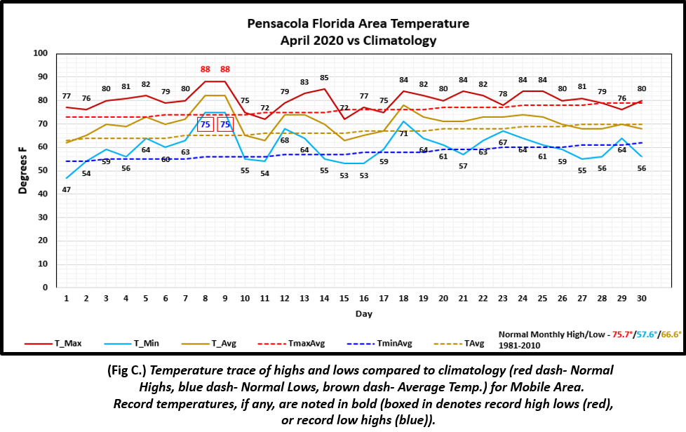
Pensacola Florida Area - The average monthly high of 80.1° was 4.4°above normal. The average monthly low of 60.4° was 2.8° above normal. The average monthly temperature of 70.3° was 3.7° above normal. (Fig. C) shows a graphical representation of how the Pensacola area temperatures compared to the seasonal normal monthly highs and lows, which are shown by the colored dashed lines. There were four record temperatures reached this month. On the 8th and 9th, a new record high low temperature of 75° was reached both mornings. On the 8th, this value smashed the previous record of 71° set in 1948; on the 9th it broke the previous record of 72° set in 1999. On the same two days, a record high of 88° was set. This broke the previous record of 86° set in 1986 on the 8th and 85° set in 1965 on the 9th. The rain gauge at Pensacola collected rain amounts closer to normal with total rainfall (Fig. D) measuring 4.07" or just 0.25" below normal. A precipitation trace for the Pensacola area is provided in the graphics below showing how it compares to normal year to date totals. The Pensacola area annual rainfall lags behind normal by five inches which has contributed to abnormally dry to moderate drought conditions over Escambia county.
Click on the Pensacola Florida area climate graphics below to expand:
|

|

|
May Climatology and Outlooks:
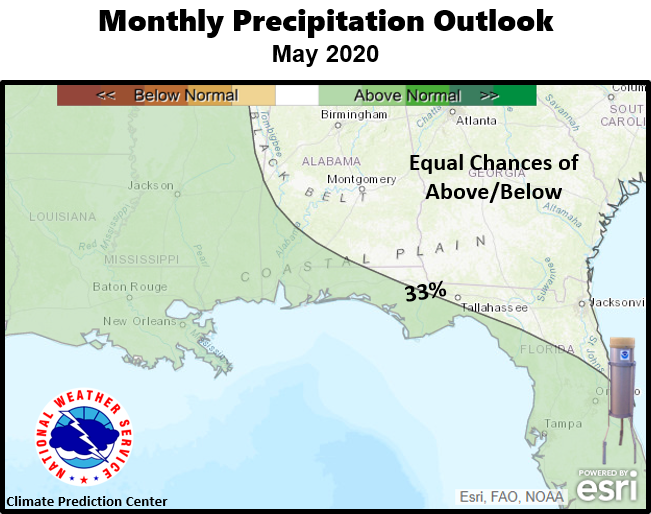
Starting to heat up as we begin the transition from the Spring season to the Summer, the latest monthly outlook favors equal chances of above or below normal temperatures for the southeast US with a 33% and higher probability of above normal temperatures along and west of the Lower Mississippi River Valley. The deep south is in need of rain, especially those counties closer to the coast which are experiencing moderate to severe drought. A 33% probability of above normal rain is outlooked for May over the Lower Mississippi River Valley with equal chances of above or below normal rain over the southeast US. For more specific information on local drought conditions and outlooks, click on the drought information and facts link below.
Click on the snap shots below to expand:

|

Outlook |
Outlook |
|
Climate Prediction Center's Interactive Long Range Outlooks
Additional Climate Links:
The links below are intended to provide additional climate information, education and outlooks. The National Weather Service Mobile Alabama's Climate and Past Weather page provides climate data at your fingertips for many observation points in the local forecast area by accessing the NOWData tab as well as many other climate resources. The Climate Prediction Center Link provides short and longer range climatic outlooks and education about the larger scale global circulations that impact temperatures and weather. With the large agriculture and farming presence along the central Gulf coast, the Drought Monitor link provides updates on drought trends and impacts. Another very helpful resource is the Community Collaborative Rain Hail and Snow (CoCoRaHS) network, which is a large group of volunteers working together to measure and map precipitation (rain, hail and snow). The aim of CoCoRaHS is to provide the highest quality data for natural resource, education and research applications. You can be a part of the CoCoRaHS team by becoming a volunteer rainfall observer. To learn more click on the CoCoRaHS link below.
National Weather Service Mobile AL Climate and Past Weather
Climate Prediction Center (CPC)
CoCoRaHS Network Water Year Summaries


