April 2018 Graphical Climate Summaries
Mobile Alabama and Pensacola Florida Area
Joe Maniscalco - Meteorologist/Forecaster/Climate Program Lead
National Weather Service Mobile Alabama
April 2018 in Review - As is typical going into the month of April and the heart of gardening season along the central Gulf Coast, Mobile and Pensacola experienced a few brief cool spells during the first and again during the middle portion of the month which resulted in monthly average low temperatures coming in slightly below normal levels. No major low temperature impacts to area growers and local gardeners over the local area. Toward the end of the month, temperatures leveled off to near seasonal. Average highs were very close to seasonal at both sites. No record temperatures were reached over the past month. Although both Mobile and Pensacola showed a deficit in rainfall, a bit more rain at Pensacola helped to keep the departure closer to climatology there.
Mobile Alabama Area - The average monthly high was 76.6° or 0.9° below normal. The average monthly low was 52.0° or 3.4° below normal. The average monthly temperature was 64.3° or 2.1° below normal. (Fig. A) shows how temperatures compared to the seasonal normal monthly highs and lows, which are shown by the colored dashed lines. April rainfall measured 3.07" or 1.72" below normal (Fig. B).
Click on the Mobile Alabama area climate graphics below to expand:


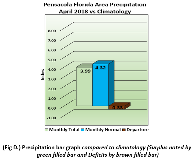
Pensacola Florida Area - The average monthly high was 76.4° or 0.7° above normal. The average monthly low was 56.1° or 1.5° below normal. The average monthly temperature was 66.3° or 0.3° below normal. (Fig. C) shows how temperatures compared to the seasonal normal monthly highs and lows, which are shown by the colored dashed lines. April rainfall measured 3.99" or 0.33" below normal (Fig. D).
Click on the Pensacola Florida area climate graphics below to expand:

Climate Outlook for Summer 2018:
See below for the latest Summer 2018 seasonal outlook issued by the Climate Prediction Center.
Click on the graphic below to expand:

Additional Climate Links:
The links below are intended to provide additional climate information, education and outlooks. The National Weather Service Mobile Alabama's Climate and Past Weather page provides climate data at your fingertips for many observation points in the local forecast area by accessing the NOWData tab as well as many other climate resources. The Climate Prediction Center Link provides short and longer range climatic outlooks and education about the larger scale global circulations that impact temperatures and weather. With the large agriculture and farming presence along the central Gulf coast, the Drought Monitor link provides updates on drought trends and impacts. Another very helpful resource is the Community Collaborative Rain Hail and Snow (CoCoRaHS) network, which is a large group of volunteers working together to measure and map precipitation (rain, hail and snow). The aim of CoCoRaHS is to provide the highest quality data for natural resource, education and research applications. You can be a part of the CoCoRaHS team by becoming a volunteer rainfall observer. To learn more click on the CoCoRaHS link below.
National Weather Service Mobile AL Climate and Past Weather
Climate Prediction Center (CPC)
CoCoRaHS Network Water Year Summaries
Questions or Comments:
Contact: Joe Maniscalco, WFO Mobile, AL at joe.maniscalco@noaa.gov


