
Early March Tornado Event
March 4th, 2025
Summary of all Local Storm Reports (LSRs) from March 4th for the NWS Mobile/Pensacola area in addition to all the LSRs across the region for this event. Storm survey teams preliminarily concluded that one long-track strong tornado, resulted in injuries, occurred in our forecast area during this event. The tally of tornadoes in our forecast area Tuesday March 4th currently stands at three:
MISSISSIPPI: 2. 1 (EF-2), 1 (EF-1)
FLORIDA: 1 (EF-0)
We plan to supplement the storm surveys with high-resolution satellite imagery as this becomes available in the coming days and weeks. The data provided on this page are considered PRELIMINARY as we continue to analyze all available data. We will add more information to this page and social media as it becomes available. We thank you in advance for your patience.
EVENT OVERVIEW
On the evening of March 4th, a storm system spawned a few tornadoes. Three tornadoes occurred within the NWS Mobile/Pensacola area: Two of those in southeast MS, one being a long track EF-2 tornado tracking across Highway 84 in Wayne County MS, touching down east of Whistler and an EF-1 tornado southwest of Ward MS. The other tornado was in northwest Florida, where a EF-0 tornado touched down briefly south of Gulf Breeze Parkway, east of Midway, FL.
Special thanks to MEMA for providing drone footage and imagery to supplement our ground survey with the Wayne County tornado survey.
Whistler MS Tornado (Wayne County, MS)
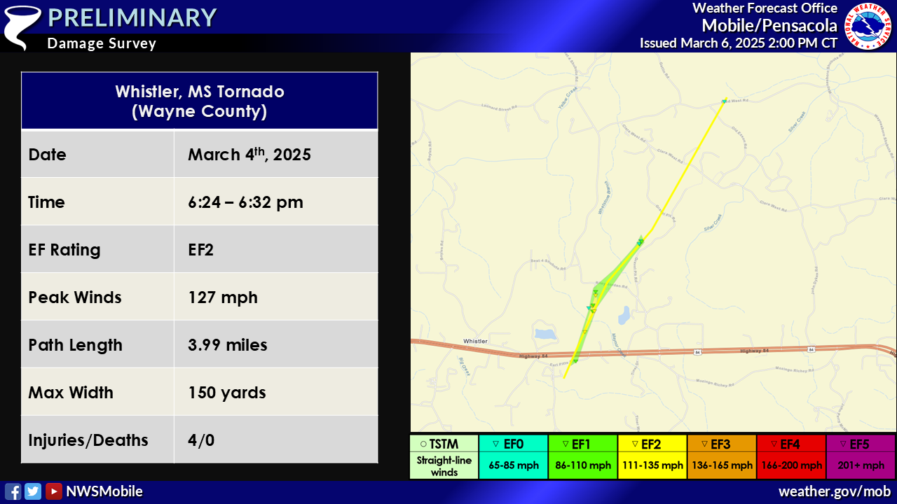
...NWS Damage Survey for 03/04/2025 Tornado Event...
.Whistler MS Tornado...
Rating:                 EF2
Estimated Peak Wind:    127 mph
Path Length /statute/:  3.99 miles
Path Width /maximum/:   150 yards
Fatalities:             0
Injuries:               4

Start Date:             03/04/2025
Start Time:             06:24 PM CST
Start Location:         1 ESE Whistler / Wayne County / MS
Start Lat/Lon:          31.6904 / -88.7855

End Date:               03/04/2025
End Time:               06:32 PM CST
End Location:           3 WSW West King / Wayne County / MS
End Lat/Lon:            31.741 / -88.753

Survey Summary:
The tornado began in the forested area near Earl Pitts Rd before
rapidly strengthening as it cross highway 84. A single vehicle
was rolled in a parking lot near highway 84 prior to the tornado
destroying several newer chicken farm buildings. The tornado then
continued north northeast across G&P farm rd where the tornado
reached peak intensity. At this location a single wide
manufactured home was tossed roughly 50 to 100 yards and
completely destroyed. The occupants were thrown from the home
resulting in two injuries at that location. A single family wood
frame home lost roughly 50 percent of its roof. The failure point
of the roof was likely due to an open carport. Further up the road,
a second manufactured home was rolled where two other injuries
occurred. A few snapped tree trunks were noted along Riley Jordan
Rd as the tornado continued northeast. The tornado paralleled
Gravel Pit Rd resulting in minor tree damage and structural
damage to a home. The roof of this home was partially removed
likely due to a large overhang porch structure attached to the
roof. A pickup truck was lofted and dropped roughly 20 yards from
its original spot bending the frame on impact. Tree damage at
this location was surprisingly minimal possibly hinting at either
a discontinuous track or very small mesovortexes within a broader
weaker parent circulation. Damage weakened significantly and the
path became difficult to find as it cross Gravel Pit Rd and then
Clara West Rd likely supporting the discontinuous path. Minor
damage was noted to trees and a manufactured home along old Exxon
rd and Fred West Rd. At this point the tornado likely dissipated
in the forest north of Fred West Rd.
Ward MS Tornado (George County, MS)
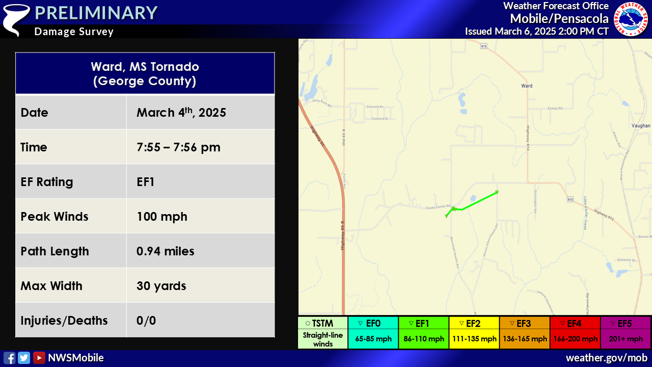
...NWS Damage Survey for 03/04/2025 Tornado Event...
.Ward MS Tornado...

Rating:                 EF1
Estimated Peak Wind:    100 mph
Path Length /statute/:  0.94 miles
Path Width /maximum/:   30 yards
Fatalities:             0
Injuries:               0

Start Date:             03/04/2025
Start Time:             07:55 PM CST
Start Location:         3 WSW Vaughn / George County / MS
Start Lat/Lon:          30.8415 / -88.5696

End Date:               03/04/2025
End Time:               07:56 PM CST
End Location:           2 WSW Vaughn / George County / MS
End Lat/Lon:            30.8463 / -88.5552

Survey Summary:
An EF1 tornado began near the intersection of Marshall Smith Road
and Cooks Corner Road where a farm building was completely
destroyed on the west side of the road. On the east side of the
road, another large outbuilding/trailer was rolled off its
supporting blocks and debris strewn towards the east across the
entire length of the field. A hardwood tree was also snapped on
the north side of the tornado vortex and another outbuilding
adjacent to this was destroyed. A narrow corridor of the debris
field was no more than 30 yards wide and made a right turn as it
continued across the field depositing debris from the destroyed
upstream structures. The tornado resumed an east-northeast path
reaching Gavin Churchwell Road where it uprooted a large hardwood
tree that was laying northeast. After this point, the tornado
likely lifted as no signs of convergent damage could be found
further northeast on Cooks Corner Road nor Highway 613.
Midway FL Tornado (Santa Rosa County, FL)
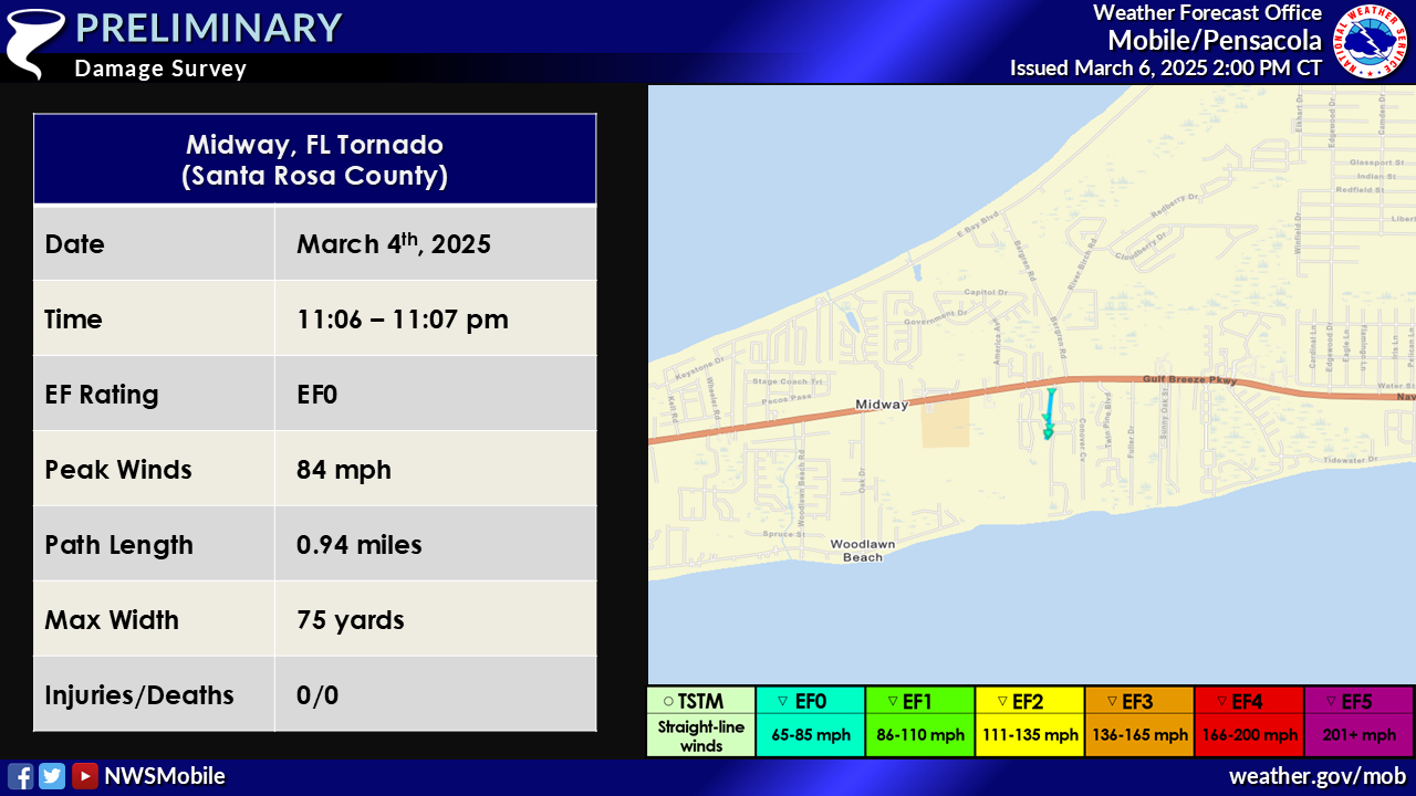
...NWS Damage Survey for 03/04/2025 Tornado Event...

.Midway FL Tornado...

Rating:                 EF0
Estimated Peak Wind:    84 mph
Path Length /statute/:  0.32 miles
Path Width /maximum/:   75 yards
Fatalities:             0
Injuries:               0

Start Date:             03/04/2025
Start Time:             11:06 PM CST
Start Location:         1 NE Woodlawn Beach / Santa Rosa County / FL
Start Lat/Lon:          30.3984 / -86.974

End Date:               03/04/2025
End Time:               11:07 PM CST
End Location:           1 NE Woodlawn Beach / Santa Rosa County / FL
End Lat/Lon:            30.403 / -86.9735

Survey Summary:
The tornado touched down along Champagne Ave, causing minor
shingle damage to several homes. As it crossed a culdesac at
Champagne Ave, a metal awning was destroyed, and an RV was
overturned. The tornado continued to the north, strengthening as
it neared Village Parkway. An RV was lifted and tossed
approximately 50 yards to the west, and several more homes
sustained minor shingle damage. The tornado lifted near the
intersection of Village Parkway and Marseille Drive. Special
thanks to Santa Rosa County Public Safety for their assistance
with this survey.
EF SCALE: THE ENHANCED FUJITA SCALE CLASSIFIES TORNADOES INTO THE
FOLLOWING CATEGORIES:

EF0...WEAK......65 TO 85 MPH
EF1...WEAK......86 TO 110 MPH
EF2...STRONG....111 TO 135 MPH
EF3...STRONG....136 TO 165 MPH
EF4...VIOLENT...166 TO 200 MPH
EF5...VIOLENT...>200 MPH

NOTE:
THE INFORMATION IN THIS STATEMENT IS PRELIMINARY AND SUBJECT TO
CHANGE PENDING FINAL REVIEW OF THE EVENT AND PUBLICATION IN
NWS STORM DATA.
Additional Information
Acknowledgments: Page created by NWS Mobile Survey Team.
LAST UPDATED: March 6, 2025

