
May Tornadoes and Significant Damaging Wind Event
May 10, 2024
Summary of all Local Storm Reports (LSRs) on May 10, 2024, as well as all the LSRs across the region for this event.
Storm survey teams preliminarily concluded that there were 2 tornadoes that occurred in our forecast area - one EF2 tornado in Monroe, Conecuh, and Butler Counties in Alabama and one EF2 tornado in Santa Rosa and Okaloosa Counties in Florida. Survey teams also found significant straight line wind damage in Monroe County, Alabama as well as in northern Santa Rosa and Okaloosa Counties in Florida.
The data provided on this page are considered preliminary as we continue to analyze all available data. We will add more information to this page and social media as it becomes available. We thank you in advance for your patience.
ALABAMA TORNADO AND DAMAGING WINDS
Midway/Georgiana Tornado (Monroe, Conecuh, and Butler Counties, AL)
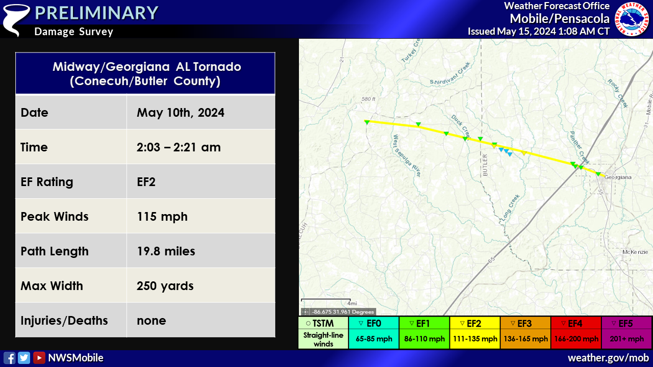
...NWS Damage Survey for 05/10/2024 Tornado Event...

.Midway Alabama to Georgiana Alabama Tornado...

Rating:                 EF2
Estimated Peak Wind:    115 mph
Path Length /statute/:  19.81 miles
Path Width /maximum/:   250 yards
Fatalities:             0
Injuries:               0

Start Date:             05/10/2024
Start Time:             02:03 AM CDT
Start Location:         3 N Skinnerton / Monroe County / AL
Start Lat/Lon:          31.7092 / -87.064

End Date:               05/10/2024
End Time:               02:21 AM CDT
End Location:           Georgiana / Butler County / AL
End Lat/Lon:            31.6402 / -86.7385

Survey Summary:
The tornado started just west of State Highway 83 about 1 mile
southwest of Midway, AL in Conecuh County at EF-1 intensity where
several trees were snapped in a rotating pattern. The tornado then
moved east and crossed Mixonville Rd just south of the community of
Mixonville where multiple pine trees were snapped and uprooted. The
tornado continued eastward and crossed the intersection of County
Road 33 and Osprey Road where additional trees were snapped with
some slight debarking noted on a few trees. The tornado peaked
in intensity at estimated EF-2 strength (115 mph) as it crossed into
Butler County where numerous pine trees were snapped in a wide
swath along portions of State Highway 106. A manufactured home was
rolled near the intersection of State Highway 106 and Interstate 65.
Trees were downed in several neighborhoods in the community of
Georgiana before the tornado likely lifted as the circulation
dissipated just east of Georgiana.
Significant Damaging Wind Swath Monroe County (Monroe County, AL)
...NWS Damage Survey for 05/10/2024 Tornado Event...

.Significant Damaging Winds Monroe County Alabama...

In addition to the tornado, swaths of significant straight line wind
damage were surveyed in Monroe County Alabama, including in the
community of Vredenburgh where a large pine tree destroyed a
residence (estimated 90 mph), near Buena Vista and Rikard`s Mill
where damaging winds uprooted and snapped trees (90 mph), along a
private camp site east of State Highway 265 where numerous trees
were snapped (100-110 mph), and near the community of Beatrice where
additional trees were downed (90 mph).
FLORIDA TORNADO AND DAMAGING WINDS
Munson, FL Tornado (Santa Rosa and Okaloosa Counties, FL)
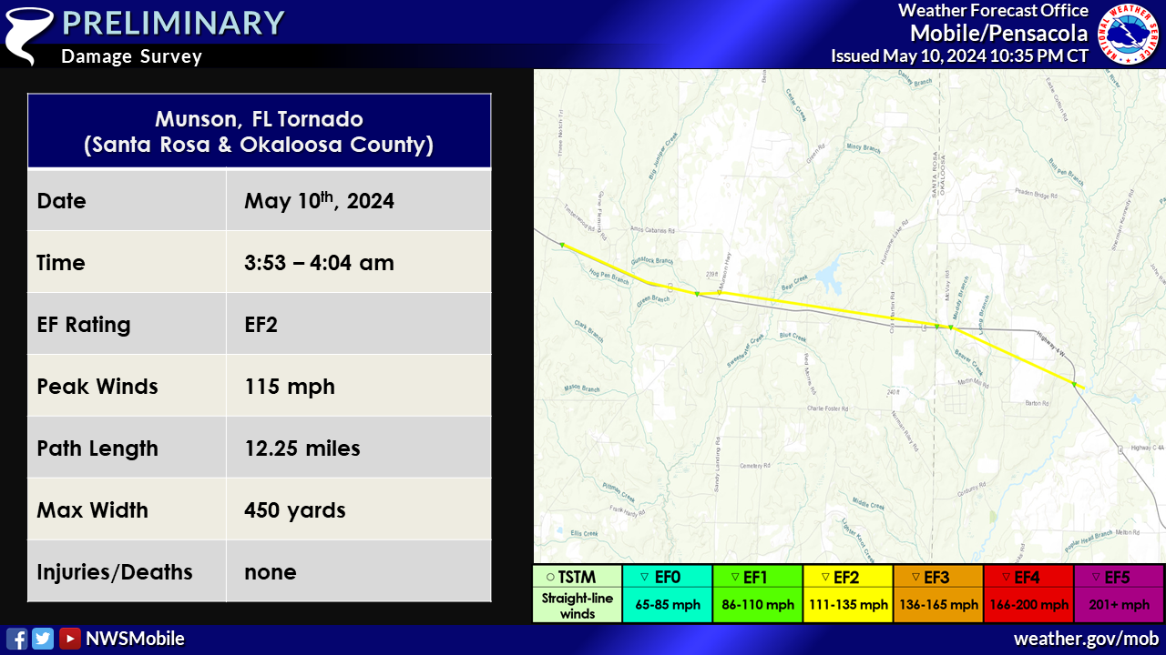
..Munson Florida Tornado...

Rating:                 EF2
Estimated Peak Wind:    115 mph
Path Length /statute/:  12.25 miles
Path Width /maximum/:   450 yards
Fatalities:             0
Injuries:               0

Start Date:             05/10/2024
Start Time:             03:53 AM CDT
Start Location:         3 WNW Munson / Santa Rosa County / FL
Start Lat/Lon:          30.8717 / -86.9323

End Date:               05/10/2024
End Time:               04:04 AM CDT
End Location:           3 WSW Nubbin Ridge / Okaloosa County / FL
End Lat/Lon:            30.8351 / -86.732

Survey Summary:
The tornado started along State Highway 4 about 3 miles west northwest of
Munson where pine trees were snapped and power lines were downed in a convergent
pattern. The tornado peaked in intensity at an estimated 115 mph (EF2) over Munson
where numerous pine trees were snapped in a convergent pattern in a swath about
450 yards wide. The tornado then took a slight jog to the east-southeast as it
essentially paralleled State Highway 4 east of Munson with numerous pine and
oak trees snapped on both sides of the road. Snaps continued into Okaloosa
County Florida where the tornado is estimated to have lifted to the northwest
of Baker.
Significant Straight Line Wind Damage in northern Santa Rosa and Okaloosa Counties (Santa Rosa and Okaloosa Counties, FL)

Survey Summary:
In addition to the tornado, large swaths of significant straight line wind damage
were surveyed in northern Santa Rosa and Okaloosa counties. Numerous wooden
power lines were snapped along State Highway 87 between Allentown and
Berrydale, where wind speeds were estimated up to between 100 and 110 mph.
Metal roofing from a small barn was also picked up and launched about 200 yards
toward the road. Numerous trees were snapped in a swath from Jay Florida
to rural locations along and south of State Highway 4 from Jay to Berrydale with
wind speeds estimated between 80 and 110 mph along this swath. Additional significant
straight line winds were observed in the community of Baker where several large
hardwood trees were downed in the same direction. A large oak tree fell on a
mobile home about 2.5 miles southeast of Baker. The damage became more sporadic
further southeast, but straight line wind damage was observed in Crestview where
an awning was stripped from a canopy over a gas station and stucco was stripped from
the side of a church.
EF Scale: The Enhanced Fujita Scale classifies tornadoes into the
following categories:

EF0...Weak......65 to 85 mph
EF1...Weak......86 to 110 mph
EF2...Strong....111 to 135 mph
EF3...Strong....136 to 165 mph
EF4...Violent...166 to 200 mph
EF5...Violent...>200 mph

NOTE:
The information in this statement is preliminary and subject to
change pending final review of the event and publication in NWS
Storm Data.
Additional Information
Acknowledgements: Page created by Caitlin Baldwin (Forecaster).
LAST UPDATED: May 2024

