
Easter Sunday Tornadoes
April 12, 2020
Summary of all Local Storm Reports (LSRs) on April 12th, as well as all the LSRs across the region for this event.
----- IMPORTANT 2023 UPDATE -----
Significant updates were made to several tornado tracks and wind swaths impacting the NWS Mobile/Pensacola area in the 2018 to 2023 timeframe thanks to the introduction of high-resolution Sentinel, Worldview, and Planet satellite imagery. One or multiple tornado tracks/wind swaths listed on this event webpage were updated in 2023.
An updated graphic and details surrounding these significant updates can be found in the list below. More information on this Local Tornado Reanalysis Project and a list of all updates can be found on our webpage at weather.gov/mob/TornadoReanalysis or the National Damage Viewer.
Here is a list of the significant updates:
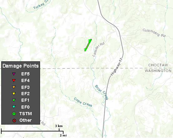
1. April 12, 2020 - Updated Tornado - Choctaw County, AL: The width of the EF1 tornado just west of the Cullomburg community in southern Choctaw County, AL was widened from 75 yards to 450 yards based on the extent of deforestation noted in high-resolution satellite imagery.
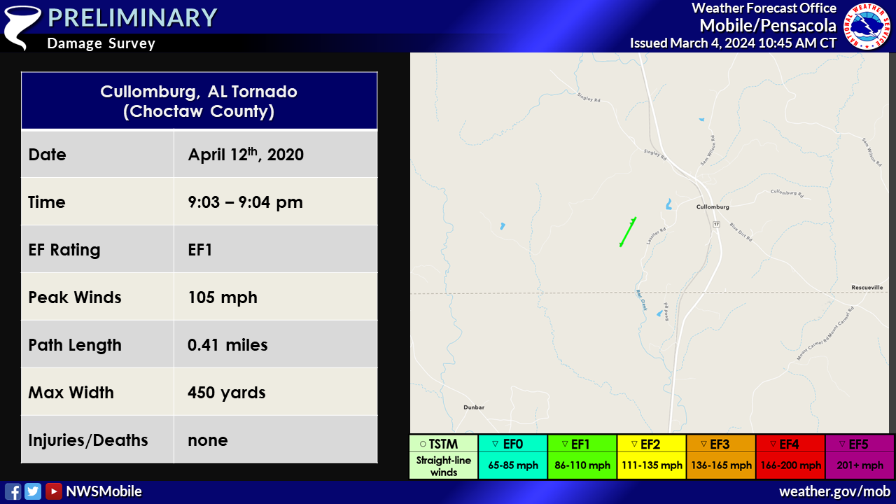
Cullomburg Tornado (Choctaw County, AL)

Public Information Statement
National Weather Service Mobile AL
706 PM CDT Tue Apr 14 2020

...NWS Damage Survey For April 12, 2020 Tornado and Damaging Wind Event...

.Cullomburg Tornado (Choctaw County)...

Rating:                 EF-1
Estimated Peak Wind:    105 mph
Path Length /statute/:  0.4 miles
Path Width /maximum/:   100 yards
Fatalities:             0
Injuries:               0

Start Date:             Apr 12 2020
Start Time:             903 PM CDT
Start Location:         1 mi SW Cullomburg
Start Lat/Lon:          31.7065/-88.3161

End Date:               Apr 12 2020
End Time:               904 PM CDT
End Location:           1 mi SW Cullomburg
End Lat/Lon:            31.7118/-88.3128

Survey summary: An EF-1 tornado touched down in a heavily wooded area
west of Lasiter Rd (also west of Highway 17.) The tornado snapped
numerous pine trees along its path. The start and end points are
estimated due to lack of access. There was also a much larger area of
straight line wind damage observed in and around Cullomburg with winds
estimated at 60-80 mph, which downed numerous trees and heavily damaged
a couple of sheds.
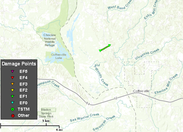
West Bend AL Tornado (Clarke County, AL)
Public Information Statement
National Weather Service Mobile AL
706 PM CDT Tue Apr 14 2020

...NWS Damage Survey For April 12, 2020 Tornado and Damaging Wind Event...

.West Bend AL Tornado (Clarke County)...

Rating:                 EF-1
Estimated Peak Wind:    105 mph
Path Length /statute/:  0.8 miles
Path Width /maximum/:   100 yards
Fatalities:             0
Injuries:               0

Start Date:             Apr 12 2020
Start Time:             916 PM CDT
Start Location:         West Bend AL
Start Lat/Lon:          31.7980/-88.1340

End Date:               Apr 12 2020
End Time:               917 PM CDT
End Location:           West Bend AL
End Lat/Lon:            31.8035/-88.1225

Survey summary: The tornado touched down approximately three quarters of a
mile west of West Bend Road and moved northwest across West Bend Road before
lifting. Numerous pine trees were snapped along the path. The start
point of the path is estimated. There was also a much larger area of
straight line wind damage observed around the area, with winds estimated
at 60-80, which resulted in tree damage.
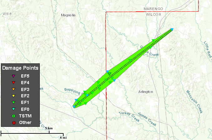
Arlington AL Tornado (Wilcox County, AL)
Public Information Statement
National Weather Service Mobile AL
706 PM CDT Tue Apr 14 2020

...NWS Damage Survey For April 12, 2020 Tornado and Damaging Wind Event...

.Arlington AL Tornado (Wilcox County)...

Rating:                 EF-1
Estimated Peak Wind:    110 mph
Path Length /statute/:  5.4 miles
Path Width /maximum/:   1000 yards
Fatalities:             0
Injuries:               0

Start Date:             Apr 12 2020
Start Time:             944 PM CDT
Start Location:         2.4 mi WNW Arlington (Marengo/Wilcox County Line)
Start Lat/Lon:          32.0690/-87.6234

End Date:               Apr 12 2020
End Time:               949 PM CDT
End Location:           1 ESE Lamison
End Lat/Lon:            32.1162/-87.5508

Survey summary: The tornado entered Wilcox County from Marengo County
just southwest of County Road 32 and lifted near County Road 30.
The most significant damage occurred along County Road 32 where numerous
pine trees were snapped. A mobile home was heavily damaged by a large
pine tree. Additional trees were either uprooted or snapped along the
path with the tornado weakening as it approached County Road 30 just
east of Lamison. Many thanks to NWS Birmingham with their assistance with
this survey.

The same storm has also resulted in numerous trees being downed across
Wilcox County from straight line winds.
EF Scale: The Enhanced Fujita Scale classifies tornadoes into the following
categories.

EF0...Weak......65 to 85 mph
EF1...Weak......86 to 110 mph
EF2...Strong....111 to 135 mph
EF3...Strong....136 to 165 mph
EF4...Violent...166 to 200 mph
EF5...Violent...>200 mph

Note:
The information in this statement is preliminary and subject to change
pending final review of the events and publication in NWS Storm Data.
Acknowledgements: Page created by Joe Maniscalco (Forecaster). Page updated by Caitlin Baldwin (Forecaster).
LAST UPDATED: March 2024

