
Early March 2019 Tornadoes
March 3, 2019
Summary of all Local Storm Reports (LSRs) on March 3rd, as well as all the LSRs across the region for this event.
----- IMPORTANT 2023 UPDATE -----
Significant updates were made to several tornado tracks and wind swaths impacting the NWS Mobile/Pensacola area in the 2018 to 2023 timeframe thanks to the introduction of high-resolution Sentinel, Worldview, and Planet satellite imagery. One or multiple tornado tracks/wind swaths listed on this event webpage were updated in 2023.
An updated graphic and details surrounding these significant updates can be found in the list below. More information on this Local Tornado Reanalysis Project and a list of all updates can be found on our webpage at weather.gov/mob/TornadoReanalysis or the National Damage Viewer.
Here is a list of the significant updates:
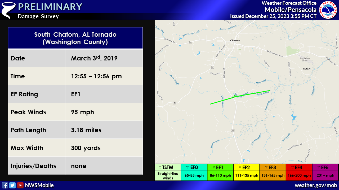
1. March 3, 2019 - Updated Tornado - Washington County, AL: The length of the tornado near the Chatom community was extended significantly based on a narrow swath of tree damage noted on high-resolution satellite imagery. The EF1 tornado occurred primarily in densely forested areas (only crossing one road), largely inaccessible to the survey team. The starting and ending points of the tornado were extended well to the west and east of Highway 17 in Washington County, AL. The path length increased from 0.17 miles to 3.18 miles. The EF1 intensity remains the same.
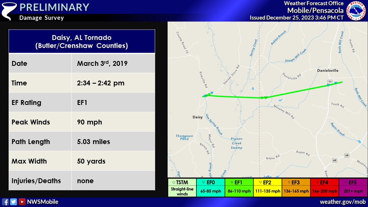
2. March 3, 2019 - Combined Tornadoes - Butler/Crenshaw Counties, AL: The initial two tornadoes that impacted Butler and Crenshaw Counties, AL between the Daisy and Danielsville communities were discovered to be the same tornado track based on Planet satellite imagery. The EF1 tornado moved across densely forested areas, largely inaccessible to the survey team. Planet satellite imagery revealed that the tornado continued across this forested area, connecting the first and second tornado tracks into one singular EF1 tornado track. The tornado starting point was also adjusted slightly west of the initial point. The tornado length is 5.03 miles, width is 50 yards, and maximum intensity is 90 mph.
Washington County, AL Tornadoes
Public Information Statement
National Weather Service Mobile AL
258 PM CST Mon Mar 4 2019

...NWS Damage Survey For March 3, 2019 Washington County Tornado
Events...

.OVERVIEW...Two tornadoes occurred in Washington County on March
3, 2019 as severe storms moved across the area.

.HIGHWAY 17 TORNADO...

Rating:                 EF-1
Estimated Peak Wind:    95 mph
Path Length /statute/:  0.17 miles
Path Width /maximum/:   300 yards
Fatalities:             0
Injuries:               0

Start Date:             Mar 3 2019
Start Time:             1255 PM CST
Start Location:         3 mi S Chatom, AL
Start Lat/Lon:          31.4188/-88.2566

End Date:               Mar 3 2019
End Time:               1256 PM CST
End Location:           3 mi S Chatom, AL
End Lat/Lon:            31.4195/-88.254

Survey summary: The tornado touched down just west of Highway 17,
3 miles south of Chatom. The tornado crossed Highway 17 and continued
east into a more forested area. The path length is an estimate as
a final end point could not be determined due to lack of road access.
The tornado produced EF-1 damage to both softwood and hardwood trees,
some of which were snapped.

.SIMS CHAPEL TORNADO...

Rating:                 EF-1
Estimated Peak Wind:    105 mph
Path Length /statute/:  2.6 miles
Path Width /maximum/:   100 yards
Fatalities:             0
Injuries:               0

Start Date:             Mar 3 2019
Start Time:             137 PM CST
Start Location:         8 mi SW McIntosh, AL
Start Lat/Lon:          31.2118/-88.1575

End Date:               Mar 3 2019
End Time:               142 PM CST
End Location:           6 mi SW McIntosh, AL
End Lat/Lon:            31.2152/-88.1142

Survey summary: The tornado began near John Johnston Road and
continued east, adjacent to Fairford Road. The tornado lifted
roughly just south of Price Rivers Road and just east of Fairford
Road. The tornado produced tree damage along its path, snapping
both softwood and hardwood trees. The most extensive tree damage
was noted near the Sims Chapel Holiness Church. At the church
itself, an addition to the church was heavily damaged. This
addition was open facing which allowed the wind to get inside of
the structure. A few structures suffered minor damage along the
patch, primarily due to downed trees. Based on radar data, the
start point of the tornado could have occurred west of John
Johnston Road, but this is in a remote area where access is limited.

EF Scale: The Enhanced Fujita Scale classifies tornadoes into the
following categories.

EF0...Weak......65 to 85 mph
EF1...Weak......86 to 110 mph
EF2...Strong....111 to 135 mph
EF3...Strong....136 to 165 mph
EF4...Violent...166 to 200 mph
EF5...Violent...>200 mph

Note:
The information in this statement is preliminary and subject to
change pending final review of the events and publication in
NWS Storm Data.
Butler and Crenshaw County, AL Tornadoes
Public Information Statement
National Weather Service Mobile AL
824 PM CST Mon Mar 4 2019

...NWS Damage Survey For March 3, 2019 Butler and Crenshaw County Tornado
Event...

.OVERVIEW...Two tornadoes occurred in Butler and Crenshaw Counties
on March 3, 2019 as severe storms moved across the area.

.BUTLER COUNTY TORNADO...

Rating: EF-1
Estimated Peak Wind: 90 mph
Path Length /statute/: 0.27 miles
Path Width /maximum/: 50 yards
Fatalities: 0
Injuries: 0

Start Date:             Mar 3 2019
Start Time:             234 PM CST
Start Location:         6 mi NW Honoraville, AL
Start Lat/Lon:          31.9074/-86.4802

End Date:               Mar 3 2019
End Time:               235 PM CST
End Location:           6 mi NW Honoraville, AL
End Lat/Lon:            31.9090/-86.4761

Survey summary: The tornado formed and damaged an outbuilding near
the intersection of Kirkville Road and Steiner Store Road before
continuing northeast into a wooded area, where numerous trees
were snapped and uprooted. The tornado then crossed Kirkville Road
and partially lifted the roof off a one story brick home before
dissipating shortly thereafter.

The National Weather Service in Mobile would like to extend our
appreciation to Butler County EMA for their assistance with storm
damage surveys today.

.CRENSHAW COUNTY TORNADO...

Rating:                 EF-1
Estimated Peak Wind:    90 mph
Path Length /statute/:  2.66 miles
Path Width /maximum/:   50 yards
Fatalities:             0
Injuries:               0

Start Date:             Mar 3 2019
Start Time:             238 PM CST
Start Location:         4.5 miles NW of Honoraville
Start Lat/Lon:          31.9065/-86.4459

End Date:               Mar 3 2019
End Time:               242 PM CST
End Location:           4.5 miles N of Honoraville
End Lat/Lon:            31.9142/-86.4016

Survey summary: The tornado formed just west of Moseley Road
where it snapped and uprooted numerous trees, including one large
tree that fell onto a mobile home. The tornado then crossed
Moseley Road damaging a nearby outbuilding before moving into a
heavily forested area where sporadic tree damage continued. The
tornado lifted shortly after crossing Bowden Road.

The National Weather Service in Mobile would like to extend our
appreciation to Crenshaw County EMA for their assistance with
storm damage surveys today.

EF Scale: The Enhanced Fujita Scale classifies tornadoes into the
following categories.

EF0...Weak......65 to 85 mph
EF1...Weak......86 to 110 mph
EF2...Strong....111 to 135 mph
EF3...Strong....136 to 165 mph
EF4...Violent...166 to 200 mph
EF5...Violent...>200 mph
Acknowledgements: Page created by Morgan Barry (Lead Forecaster).
LAST UPDATED: March 2024

