
Late April Tornado Event
April 22, 2018
Summary of all Local Storm Reports (LSRs) of other storm damage across the area on April 22nd, as well as all the LSRs across the region for this event (regional map may take a minute to load).
----- IMPORTANT 2023 UPDATE -----
Significant updates were made to several tornado tracks and wind swaths impacting the NWS Mobile/Pensacola area in the 2018 to 2023 timeframe thanks to the introduction of high-resolution Sentinel, Worldview, and Planet satellite imagery. One or multiple tornado tracks/wind swaths listed on this event webpage were updated in 2023.
An updated graphic and details surrounding these significant updates can be found in the list below. More information on this Local Tornado Reanalysis Project and a list of all updates can be found on our webpage at weather.gov/mob/TornadoReanalysis or the National Damage Viewer.
Here is a list of the significant updates:
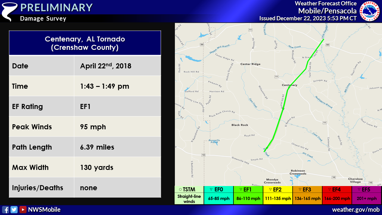
1. April 22, 2018 - Updated Tornado - Crenshaw County, AL: The length of the tornado that moved through the Centenary community in Crenshaw County, AL was extended significantly based on a narrow path of uprooted trees noted on Planet satellite imagery. The EF1 intensity remains the same. The tornado length was extended from 3.63 miles to 6.39 miles.
Baldwin County (Alabama) EF0 & EF1 Tornadoes
Public Information Statement
National Weather Service Mobile AL
1042 PM CDT Sun Apr 22 2018

...NWS Damage Survey For The 04/22/2018 Baldwin County Tornado Events...

.Foley, AL Tornado...

Rating:                 EF-0
Estimated Peak Wind:    80 mph
Path Length /statute/:  1.6 miles
Path Width /maximum/:   100 yards
Fatalities:             0
Injuries:               3

Start Date:             April 22, 2018
Start Time:             3:25 pm CDT
Start Location:         3 miles south of Foley, AL
Start Lat/Lon:          30.3607, -87.6872

End Date:               April 22, 2018
End Time:               3:28 pm CDT
End Location:           1.9 miles southeast of Foley, AL
End Lat/Lon:            30.3808, -87.6741

Survey summary: The tornado first touched down at the Anchors
Aweigh RV Resort where it overturned 5 RVs. 3 people who were in
the RVs were injured. The tornado continued northeast to just east
of the intersection of Highway 59 and County Road 20. Minor damage
to a convenience store canopy and to the Lowe`s were observed. The
tornado lifted near the intersection of Pride Drive and Juniper
Street. Spotty minor tree damage was noted along the path.


.Vicinity of Elberta, AL Tornado...

Rating:                 EF-0
Estimated Peak Wind:    80 mph
Path Length /statute/:  1.04 miles
Path Width /maximum/:   100 yards
Fatalities:             0
Injuries:               0

Start Date:             April 22, 2018
Start Time:             3:38 pm CDT
Start Location:         2.6 miles north-northeast of Elberta, AL
Start Lat/Lon:          30.4483, -87.5808
End Date:               April 22, 2018
End Time:               3:41 pm CDT
End Location:           3.6 miles north-northeast of Elberta, AL
End Lat/Lon:            30.4633, -87.5807

Survey summary: The tornado first touched down near the
intersection of County Road 87 and Chatelaine Drive. A few homes
experienced shingle damage. Some trees were also uprooted. The
tornado continued moving almost due north, paralleling just east
of County Road 87, lifting south of the Dixie Road intersection.
Minor tree damage was noted along the path along with isolated
instances of very minor structural damage to a few residences.

Note:
The information in this statement is preliminary and subject to
change pending final review of the events and publication in
NWS Storm Data.
Public Information Statement
National Weather Service Mobile AL
146 PM CDT Tue Apr 24 2018

...NWS Damage Survey For The Gulf Shores, AL Tornado Event...

.Gulf Shores, AL Tornado...

Rating:                 EF-1
Estimated Peak Wind:    95 mph
Path Length /statute/:  0.16 miles
Path Width /maximum/:   25 yards
Fatalities:             0
Injuries:               0

Start Date:             April 22, 2018
Start Time:             3:05 pm CDT
Start Location:         3.4 miles west of Gulf Shores, AL
Start Lat/Lon:          30.2376, -87.7571

End Date:               April 22, 2018
End Time:               3:06 pm CDT
End Location:           3.4 miles west of Gulf Shores, AL
End Lat/Lon:            30.2399, -87.7567

Survey summary: A strong waterspout moved onshore at the 2200
block of West Beach Boulevard. The tornado produced roof and
siding damage to two homes. Several windows were also blown out.

Note:
The information in this statement is preliminary and subject to
change pending final review of the event and publication in
NWS Storm Data.
Northwest Florida Panhandle EF0 & EF1 Tornadoes
Public Information Statement
National Weather Service Mobile AL
708 PM CDT Mon Apr 23 2018

...NWS Damage Survey For 04/22/2018 Florida Panhandle Tornado Events...

.Fort Walton Beach, FL Tornado...

Rating:                 EF-1
Estimated Peak Wind:    100-105 mph
Path Length /statute/:  1.24 miles
Path Width /maximum/:   50 yards
Fatalities:             0
Injuries:               2

Start Date:             April 22, 2018
Start Time:             4:13 pm CDT
Start Location:         Okaloosa Island
Start Lat/Lon:          30.3963, -86.6230

End Date:               April 22, 2018
End Time:               4:18 pm CDT
End Location:           Fort Walton Beach
End Lat/Lon:            30.4136, -86.6174

Survey summary: The tornado moved ashore on Okaloosa Island and produced
significant damage to a home on Sailfish Drive. The tornado then moved
across Santa Rosa Sound and into Fort Walton Beach, producing tree damage
and broken windows at St Mary Catholic Church and School. The tornado
continued northeast across Robinwood Drive and damaged the roofs of several
units in an apartment complex, before finally weakening and lifting just
north of Jet Drive.

.Molino, FL Tornado...

Rating:                 EF-0
Estimated Peak Wind:    85 mph
Path Length /statute/:  0.13 miles
Path Width /maximum/:   25 yards
Fatalities:             0
Injuries:               0

Start Date:             April 22, 2018
Start Time:             1:02 pm CDT
Start Location:         4.5 miles west of Molino
Start Lat/Lon:          30.7319, -87.3892

End Date:               April 22, 2018
End Time:               1:03 pm CDT
End Location:           4.5 miles west of Molino
End Lat/Lon:            30.7338, -87.3889

Survey summary: There was a brief EF-0 track on Crabtree Church Road. One
home suffered shingle damage and a broken window and a mobile home was
shifted on its foundation. There were also several uprooted small trees
and numerous large branches broken.

Note:
The information in this statement is preliminary and subject to
change pending final review of the events and publication in
NWS Storm Data.
Crenshaw County (Alabama) EF1 Tornadoes
Public Information Statement
National Weather Service Mobile AL
1143 PM CDT Mon Apr 23 2018

...NWS Damage Survey For The Crenshaw County, AL Tornado Events...

.Rural Western Crenshaw County Tornado...

Rating:                 EF-1
Estimated Peak Wind:    95 mph
Path Length /statute/:  3.9 miles
Path Width /maximum/:   150 yards
Fatalities:             0
Injuries:               0

Start Date:             April 22, 2018
Start Time:             1:43 pm CDT
Start Location:         8.4 miles west-northwest of Luverne, AL
Start Lat/Lon:          31.7537, -86.4005

End Date:               April 22, 2018
End Time:               1:50 pm CDT
End Location:           9.4 miles northwest of Luverne, AL
End Lat/Lon:            31.8056, -86.3837

Survey summary: The EF-1 tornado touched down just prior to
crossing Jeffcoast Road, and then moved north-northeast
destroying a manufactured home, causing moderate damage to a
second manufactured home, destroyed a shed, and uprooted and
snapped large trees, one of which fell on a vehicle. The tornado
was at its widest as it then cut through a grove of trees, and
open fields before crossing Chapel Hill Road. A metal roof was
then torn off a barn and thrown one-third of a mile back to the
south. The tornado then caused sporadic damage as it passed
through mainly wooded areas uprooting and snapping large trees,
with one falling on a house causing minor damage, before lifting
lifting near Center Ridge Road.

.Rural Northeast Crenshaw County Tornado...

Rating:                 EF-1
Estimated Peak Wind:    100 mph
Path Length /statute/:  2.1 miles
Path Width /maximum/:   175 yards
Fatalities:             0
Injuries:               0

Start Date:             April 22, 2018
Start Time:             2:11 pm CDT
Start Location:         3.3 miles south-southeast of Highland Home, AL
Start Lat/Lon:          31.9085, -86.3063

End Date:               April 22, 2018
End Time:               2:15 pm CDT
End Location:           2.0 miles southeast of Highland Home, AL
End Lat/Lon:            31.9362, -86.2883

Survey summary: The tornado touched near Daniel Mill Road causing
minor tree damage and then passed through mainly wooded areas as
it moved north-northeast. The tornado strengthened to an EF-1
before reaching Oliver Myers Road, passing through mainly wooded
areas uprooting and snapping large trees as it approached a small
lake in the Magnolia Shores area. The tornado caused minor to
moderate damage to several homes around the lake, mainly to roofs
and siding. The tornado then proceeded through more woods before
dissipating.

Note:
The information in this statement is preliminary and subject to
change pending final review of the events and publication in NWS
Storm Data.
Rural Southeast Escambia County (Alabama) Thunderstorm Wind Event
Public Information Statement
National Weather Service Mobile AL
1042 PM CDT Mon Apr 23 2018

...NWS Damage Survey For 04/22/2018 Southeast Alabama Thunderstorm Wind Event...

.Southeast Escambia County AL Thunderstorm Wind Event...

Peak Wind /E/:          75-80 mph
Path Length /statute/:  Sporadic damage along roughly 1.2 miles
Path Width /maximum/:   0.25 mile
Fatalities:             0
Injuries:               0

Start Date:             April 22, 2018
Start Time:             1:49 pm CDT
Start Location:         6.5 miles east-northeast of Dixonville
Start Lat/Lon:          31.0124, -86.9281

End Date:               April 22, 2018
End Time:               1:51 pm CDT
End Location:           7.1 miles northeast of Dixonville
End Lat/Lon:            31.0278, -86.9217

Survey summary: A severe thunderstorm moved across the Florida state line
into rural southeastern Escambia County in Alabama and produced areas of
sporadic straight line wind damage. Several large trees were uprooted along
Raintree Rd. More trees were uprooted along Yellow Creek Rd with several
trees snapped in half and laying in the adjacent field between Raintree
and Yellow Creek Rds. There was minor damage to a shed and an awning/roof
of a manufactured home along Yellow Creek Rd. Sporadic tree damage was also
noted further north on Yellow Creek Rd near Fuqua Rd.
Acknowledgements: Page created by Morgan Barry (Forecaster) and Joe Maniscalco (Forecaster).
LAST UPDATED: March 2024

