Melbourne, FL
Weather Forecast Office
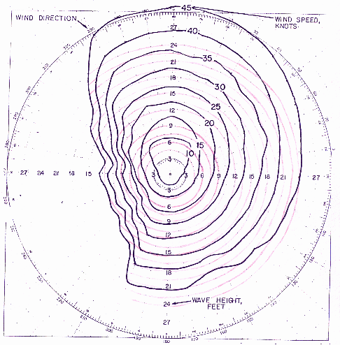
Wave Heights in Gulf Stream Nomogram

Significant wave heights over the Gulf Stream for wind speed/direction with an 18 hour duration. Red contours trace the wave height. Note that a 20 knot northeast wind can build sea heights in the Gulf Stream to around 12 feet and a 15 knot northeast wind can build sea heights to about 9 feet!
Boaters sometimes complain that the Coastal Waters Forecast underestimates the wave heights, when in fact they actually ventured out into the Gulf Stream when there was a north to northeast wind! Additionally, wave theory predicts that wave heights will occasionally be higher.
CURRENT HAZARDS
Hazardous Weather Outlook (Graphical)
Florida Hazards (CAP Text)
Outlooks
Storm Reports (Text)
Storm Reports (Graphical)
Cold Weather Support
FORECASTS
Area Forecast Discussion
Aviation Weather
Fire Weather
Graphical
Marine Weather
Probabilistic
Text Products
Tropical Weather
Winter Probabilistic
CURRENT WEATHER
Local Analysis
Observations
Precip Analysis
Satellite Images
Rivers/Lakes
RADAR IMAGERY
Melbourne Standard
Melbourne Enhanced
Regional - Southeast
Area Radars
US Dept of Commerce
National Oceanic and Atmospheric Administration
National Weather Service
Melbourne, FL
421 Croton Road
Melbourne, FL 32935
321-255-0212
Comments? Questions? Please Contact Us.

