Understanding and Using Doppler Weather Radar

Melbourne's Weather Forecast Office and Dual-Polarization Radar.
The Basics of How Radar Works
Imagine a beam of energy, called radio waves, emitted from an antenna. As they strike objects in the atmosphere, the energy is scattered in all directions with some of the energy reflected directly back to the Radar (RAdio Detection And Ranging). The larger the object, the greater the amount of energy that is returned to the radar. This provides us with the ability to “see” raindrops in the atmosphere. In addition, the time it takes for the beam of energy to be transmitted and returned to the radar also provides us with the distance to that object. Radar has been utilized since the 1940’s and is the most effective tool to detect precipitation.
Doppler Weather Radar
By design, Doppler radar systems can provide information regarding the movement of targets as well as their position. When the NEXRAD (Next Generation Radar) WSR-88D (Weather Surveillance Radar, 1988, Doppler) transmits pulses of radio waves, the system keeps track of the phase (shape, position, and form) of those pulses. By measuring the shift (or change) in phase between a transmitted pulse and a received echo, the target’s movement directly toward or away from the radar is calculated. This provides a velocity along the direction the radar is pointing, called radial velocity. A positive phase shift implies motion toward the radar and a negative shift indicates motion away from the radar.

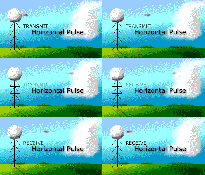
Doppler radar sends the energy in pulses and listens for any returned signal.
The phase shift effect is similar to the “Doppler Shift” (or the “Doppler Effect”) observed with sound waves. With the Doppler Shift, the sound pitch of an object moving toward your location is higher due to compression (a change in the phase) of sound waves. As an object moves away from your location, sound waves are stretched resulting in a lower frequency. An animation illustrating how the Doppler effect causes a car engine or siren to sound higher in pitch when it is approaching than when it is receding. The red circles represent sound waves. Another example of this would be an emergency vehicle or train. As the vehicle or train passes your location, the siren or whistle’s pitch lowers as the object passes by.
Doppler radar pulses have an average transmitted power of about 700,000 watts. By comparison, a typical home microwave oven will generate about 1,000 watts of energy. Yet, each pulse only lasts about 0.00000157 seconds (1.57x10⁻⁶), with a 0.00099843 second (998.43x10⁻⁶) “listening period” in between. Therefore, the total time the radar is actually transmitting a signal (when the duration of transmission of all pulses, each hour, are added together), is for a little over 7 seconds each hour. The remaining 59 minutes and 53 seconds are spent listening for any returned signals. The number of WSR-88D’s in the nation, to include Guam and Puerto Rico, is 155. The WSR-88D can detect most precipitation within approximately 80 miles of the radar, and intense precipitation can be picked up within around 140 miles. Sometimes echoes from intense precipitation or very tall cloud heights in the distance can begin showing up “weakly” as far away as around 200 miles.
Doppler Radar: A Look Inside Melbourne’s Radar

The NWS Melbourne, FL radar Tower stands 98 feet. The Radar Pedestal holds the radar antenna (dish). The Radar Antenna’s basic role is to act as a transducer between the free space and the electromagnetic wave sources or receivers. During transmission, it is used to concentrate the radiated energy into a shaped beam or in a desired direction. The speed of the rotation depends on the operating mode of the radar. We pull radar data into a computer system called AWIPS (Advanced Weather Interactive Processing System).
While our weather office and associated Doppler radar covers 10 counties in east central Florida, we can also utilize adjacent and neighboring radars in Jacksonville, Tampa, Miami, as well as Federal Aviation Administration (FAA) Terminal Doppler Weather Radars (TDWRs) in Orlando, Palm Beach, and Tampa, that we can display in AWIPS.
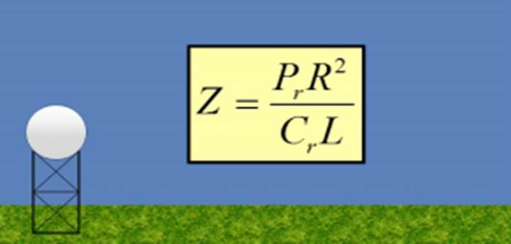
The power received by the radar is given by the "Weather Radar Equation" (below), composed of constants and variables. We can drastically simplify this equation by combining many of these terms into what is called the “radar constant” which is just various aspects of the radar system that usually remain constant or are assumed to be constant with the WSR-88D. These constants include transmitter power, antenna gain, beam width, pulse width, dielectric constant, and wavelength. The entire goal of the weather radar equation is to take the power returned from weather objects, and convert that value into something useful, and this something is called Reflectivity Factor or Z.

By combining all those previously mentioned terms into the “radar constant” or Cr, and solving for Z, we get this simplified radar equation. L represents signal loss factors associated with attenuation and receiver detection. This allows the radar software to target precipitation to be displayed on a computer monitor.
Conventional Doppler radars, prior to Dual-Polarization, send out a horizontal pulse that give forecasters a oneâ€dimensional picture of whatever is in the air, precipitation or nonâ€precipitation. It can see precipitation, but can’t tell the difference between rain, snow, or hail. Dualâ€polarization radars (also referred to as Dual Pol) is an advanced technology currently used by Doppler radars. Dual pol radars send and receive both horizontal and vertical pulses, providing a much more informative twoâ€dimensional picture of whatever is out there. Dual Pol allows us better discrimination between precipitation and non-precipitation targets. This information helps forecasters clearly identify precipitation type including rain, hail, snow or ice pellets, and other objects, improving forecasts for all types of weather. It also allows for improvement in precipitation estimates and leads to better tornado warning lead times. The WSR-88D here in Melbourne received its Dual Pol upgrade in January of 2012. With Dual Pol technology, when the radar transmits pulses of radio waves, the system keeps track of the phase, that is the shape, position, form of those pulses.
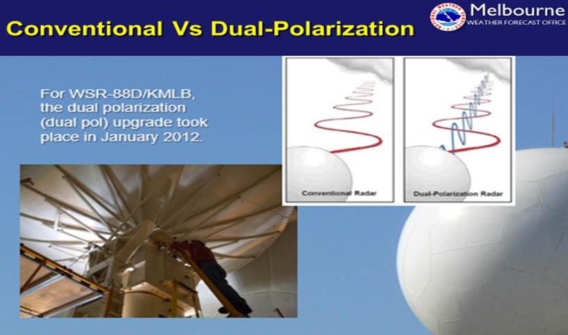

Another important benefit is dual-pol more clearly detects airborne tornado debris (the debris ball) – allowing forecasters to confirm a tornado is on the ground and causing damage so they can more confidently warn communities in its path. This is especially helpful at night when ground spotters are unable to see the tornado.
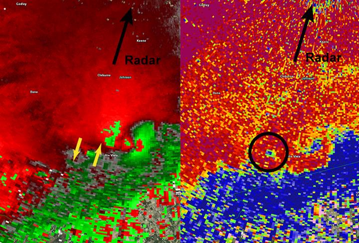
These two images (above) show how dual-pol helps the NWS forecaster detect a tornado producing damage. The left image shows how the Doppler radar can detect rotation. Between the two yellow arrows, the red color indicates outbound wind while the green colors indicate inbound wind relative to the location of the radar. Prior to dual-polarization, this is all we knew that there is a rotation near the earth’s surface. Unless there were storm spotters visibly watching the storm, we would not know for certain that a tornado was present. The image on the right shows how dual-pol information helps detect debris picked up by the tornado so we have a high degree of confidence of a tornado, and can track its path, as these two areas coincide.
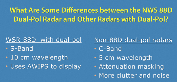
Have you ever wondered about the difference between the NWS WSR-88D Dual-Pol radar and other radars with Dual-Pol? It has to do with wavelength. Wavelength is simply the distance between successive crests of a wave, especially points in a sound wave or electromagnetic wave. Band is determined by wavelength the radar is emitting. The S-Band is used by the NWS, airport surveillance radars for air traffic control, surface ship radars, and some communication satellites, especially those used by NASA. They provide better detail, no delay in data, and larger range (out to near 200 miles)/less attenuation than other radars. Attenuation is simply the interruption of a radar beam by intense precipitation, preventing the radar beam from reaching its maximum range. For S-Bands, the radar beam can go through one storm and others while still sending back good data. A wet radar dome can also cause attenuation. The C-Band is Dual-Pol for most TV stations, though some do have S-Bands. C-Band is used by many satellite communication transmissions. They experience more attenuation than S-Bands. Data quality is not always as good.
To enable us to see the same storm from different perspectives (see below), we fortunately have the ability to utilize adjacent radars in addition to the NWS Melbourne radar. The radar beam becomes wider (broader) further from the radar. Since storm motions are averaged within the beam width, circulations further away will "appear" weaker. Therefore, rotation within storms closer to the radar are generally detected better than rotation within storms from greater ranges. To compensate for this bias, severe weather warning thresholds are lowered for storms at greater ranges.

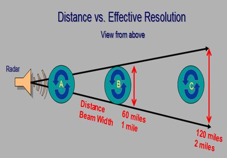
To add to the discussion, we can show radar beam broadening by comparing two radars (below).

Radar “B” is closer to the storm than Radar “A”. Radar ‘B’ will likely have a better overall and accurate profile of the storm than Radar “A”, as the greater distance from the storm will likely cause the storm to appear weaker than it really is on Radar ‘A’.
The NWS Doppler radar employs scanning strategies in which the antenna automatically raises to higher and higher present angles, called elevation slices, as it rotates. These elevation slices comprise a Volume Coverage Pattern (VCP). Once the radar sweeps through all elevation slices a volume scan is complete. The WSR-88D radar is operated in one of two modes – “Clear Air” mode or “Precipitation” mode. In Clear Air mode, images are updated every 10 minutes. In precipitation mode, the radar completes a volume scan every 4-6 minutes depending upon which VCP is in operation, providing a 3-dimensional look at the atmosphere around the radar site. So, one thing to gather from this slower antenna rotation equates to higher data quality; whereas higher antenna rotation equates to lower data quality.
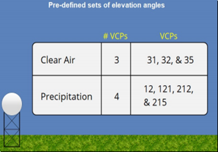
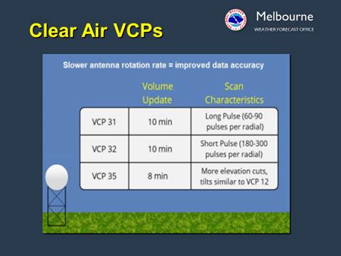
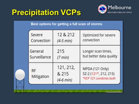
Clear Air mode VCPs operate using a much slower antenna rotation. The need for rapid updates is minimal. Used for clear air situations (generally no precipitation), but can also be used for snow, and light rain, as this equates to better sensitivity! Precipitation mode VCPs are the best options during significant precipitation events because they scan to higher elevations allowing for a more complete picture of the storms. The Severe Convection grouping provides good coverage in the lower levels with fast update times. The only significant difference between these two VCPs (12/212) is the Range Folding (RF) Mitigation algorithm used (for VCP 212). Range Folding is basically when the radar is unable to determine the wind’s velocity. This is due to the speed at which the radar transmits signals, called the Pulse Repetition Frequency or PRF, that is, the speed at which the radar transmits signals. Forecasters are able to use some VCPs specifically that contain certain algorithms to unfold range ambiguities and recover velocity estimates in weaker signals. VCP 215 was developed for General Surveillance that doesn’t require extensive low-level coverage. It is the most common VCP used and is mainly for common precipitation, generally non-severe.
In terms of elevation scanning (Radar Scanning Pattern), there is something called the “Cone of Silence”. The radar is limited close in by its inability to scan directly overhead. Therefore, close to the radar, data are not available due to the radar’s maximum tilt elevation of 19.5â°. That is why it is important for the radar operator to look at surrounding radars as well. Surrounding WSR-88Ds or nearby Terminal Doppler Weather Radars are invaluable to us meteorologists.
Applying Dynamic Scanning Strategies with Interrogation Algorithms
So, after picking a VCP, the radar operator can decide on applying a Dynamic Scanning Strategy. One such strategy is called SAILS, which stands for Supplemental Adaptive Intra-Volume Low-Level Scan. This works with our precipitation VCPs: 215, 12, and 212. The user can request up to 3 supplemental (0.5 degree) scans per volume scan. This simply allows us a second look at lower levels. So, roughly, every two minutes as the radar is scanning upward toward 19.5 degrees, it will drop back down to sample a 0.5 elevation cut, before jumping back up to begin again where it left off. As mentioned, the radar user can select between 1 and 3 additional 0.5 elevation cuts per volume scan, when SAILS is enabled. This dynamic scanning strategy is especially important in an environment in which rotation is favorable in storms and allows the forecaster to detect potential tornado formation. See the image below.

There are two precipitation images made available via the web: One-hour precipitation and Storm Total Precipitation. These are estimated accumulations only.
The maximum range of these two images is 124 nautical miles (143 statute miles/230 kilometers) from the radar location. They will not display accumulated precipitation more distant than 124 nautical miles, even though precipitation may be occurring at greater distances. To determine accumulated precipitation at greater distances you should look at adjacent radars.
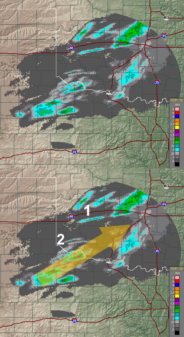
One Hour Precipitation: Just as the name implies, this is an image (below) of the estimated precipitation during the previous hour. There are two main factors to consider when viewing this image. First, while the radar does a great job at correcting itself, there are times when the radar will be out of calibration. If the radar is "hot" (reporting echoes too strong) then the rainfall estimates will be an overestimate. Conversely, a "cool" radar will underestimate the precipitation. Always check nearby radars to see if they are reporting similar information to what is viewed by your local radar. Second, hail makes an excellent reflector of energy. Thunderstorms with hail will overestimate the amount of precipitation and the larger the hailstones, the greater the overestimate.
Besides estimating rainfall, both the static and looping one-hour precipitation images can provide other useful information. This image is a good way to track individual storms. The overall motion of the storms is indicated by the large yellow arrow. However, at #1 (below) there are storms moving in three directions. The first thing to notice is storms DO NOT always move parallel to the upper level winds. Some storms can move left, or right, of the upper level flow. Thunderstorms also do not always move in straight lines. Sometimes they curve as in the case of the two small storms to the right of #2. This is valuable information as storms that tend to move right of the main airflow, either in a straight line or curved path, are often capable of producing severe weather. The "right movers" may be difficult to see on looping Base Reflectivity images but the rainfall pattern they leave behind can be invaluable in knowing which storms require extra attention. Base reflectivity is a display of echo intensity (reflectivity) measure in dBZ (decibels of Z, where Z represents the energy reflected back to the radar). "Reflectivity" is the amount of transmitted power returned to the radar receiver.
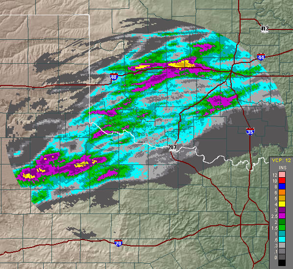
Storm Total Precipitation: Just as the name implies, this is an image (below) of the estimated accumulation since the precipitation began. The accumulation continues until there is not precipitation for one hour anywhere within the range of the radar. Often, in prolonged rainy periods, this accumulation can exceed five days or more. On the radar page, the accumulation time period for this image is located on the right side, just above the image.
There are two main types of radar data. The first is Reflectivity. Reflectivity data shows us the strength of the energy that is returned to the radar after it bounces off precipitation targets. Other non-precipitation targets will return energy that will be discussed further below. In this Base Reflectivity image below, the colors represent the strength of returned energy to the radar expressed in values of decibels or dBZ. The color scale is located at the left of the image in this example. As dBZ values increase so does the intensity of the rainfall.
You have probably heard both the terms, Base Reflectivity and Composite Reflectivity, the difference is simply Base Reflectivity only shows the reflected energy at a single elevation scan of the radar; whereas Composite Reflectivity shows the highest dBZ or strongest reflected energy at all elevation scans. Learn more about Reflectivity here.

The second type of data is Velocity. Velocity data is derived from the phase, or Doppler Shift of the returned energy. The radar’s computer algorithms will calculate the shift and determine whether the precipitation is moving toward (inbound) or away (outbound) from the radar, and how fast, then apply a corresponding color to those directions and speeds. Red is typically a target moving away from the radar, while Green is applied to targets moving toward the radar. The intensity of these colors determines its estimated speed.
In the Velocity image below, which is simply a picture of the basic wind field from the lowest ½ degree elevation scan or slice, we can determine the radar location. If the radar cannot determine (called Range Folding) inbound or outbound then it paints the wind in purple.
For the meteorologist, velocity is important for determining areas of strong wind from downbursts or detecting the speed of cold fronts. In the image below, we can see bright red, even yellow, representing outbound velocities, right next to the bright green, or inbound velocities. This indicates a strong rotating column of air. When coupled with a reflectivity pattern that exhibits a hook signature, that we just saw on the previous image, there may be a tornado occurring or one about to occur. We can definitely term what we see above as a “Mesocyclone”, which is simply a storm-scale region or rotation. An area where tornadoes often form.
One thing to keep in mind when looking at these images is the radar beam elevation (from the radar location) increases with increasing distance from the radar. Therefore winds further from the radar represent speeds at a much higher level in the atmosphere are not representative of ground level at that certain location. Learn more about Velocity here.

Sometimes the WSR-88D Doppler Radar Sees Non-Precipitation Targets: If there is a "target" out there and it reflects radar energy back to the radar, the radar will display it as if it was precipitation. The radar does have some logic built in to help it discriminate between precipitation and non-precipitation targets. But, sometimes we see curious things on our radar display. Here are several (below) along with some various other interesting radar detections:
Bird Roost Rings: These are most common in the fall and winter around bodies of water. At night, birds rest/nest in and around the lakes. Just before sunrise, there is often a coordinated lift off and dispersion of the birds out into the surrounding fields for feeding during the day.
Anomalous Propagation (AP): (Ground Clutter). Anomalous Propagation (AP) refers to meteorological situations where a signal comes back to the radar antenna even in the absence of precipitation and is most common on the lowest elevation slices. It disappears on higher elevation slices. AP is transient and highly dependent on atmospheric conditions. In many cases AP occurs when atmospheric conditions are favorable for Super-Refraction. Super-Refraction occurs when the beam propagates through a layer where (1) temperature increases with height or (2) moisture decreases sharply with height. This will likely produce Ground Clutter. Ground clutter is the most common AP and easiest False Echo to identify on radar since it DOES NOT move. Melbourne's radar is often a victim to early morning ground clutter and can be commonly a result of high pressure ridging over the area or a subsidence inversion. The AP generally filters out through the morning as surface heating occurs and the inversion lifts or mixes out. If you feel that you may have AP on your local radar, always get a second opinion for what is displayed on radar. Look at adjacent radars to determine if they area seeing the same thing. Also check out visible satellite imagery. AP WILL NOT show up on satellite imagery. AP often contaminates precipitation measurements and can cause the generation of erroneous rainfall estimates used in hydrology products.
In the image provided for ground clutter above, high pressure is overhead and east central Florida was experiencing a strong morning inversion. The only precipitation on the image is over the local coastal waters of the western Atlantic, to the east. AP is only one type of ground clutter. Another is Normal Ground Clutter. This exists all the time, such as, elevated terrain, trees, and buildings that can get in the way of the radar beam.
It's important to remember that moving objects are not considered to be ground clutter. The WSR-88D clutter algorithms require clutter echoes to have near zero velocity to be detected. So, basically, anticipate contamination from moving ground targets such as wind farms and traffic on highways when the proper conditions exist to detect them.
Outflow Boundaries/Gust Fronts: In the image, you can see the east coast sea breeze boundary (north-south) moving inland from the east coast. Ahead of it are a couple of small showers producing an outflow boundary or "gust front" around them. These boundaries separate thunderstorm cooled air from warmer surrounding air. These additional boundaries collide with sea breeze, lake breeze, and even other storm produced boundaries and can initiate new showers and storms. These can often be seen on radar in the "wet" season/summer across Florida. This leads to a high coverage of precipitation as well as erratic movement of cells, especially when the steering flow aloft is weak. In this case, the stronger boundary can dictate which way the cell will propagate. This is another graphic showing outflow boundaries pushing cool air in many directions from a cluster of thunderstorms.
Space Launch Anomalies and Launch Smoke/Debris Plumes: The WSR-88D will also pick up plumes from space launch anomalies from Cape Canaveral. Note from the animation that the plume seems to dissipate as it ventures further east across the near shore waters of the western Atlantic. One thing to keep in mind is that the 0.5 degree elevation slice will be viewed from a higher elevation the further it gets from the radar. Therefore the plume is not necessarily dissipating, but the radar may be overshooting it farther away within the image. The vertical stability of the atmosphere (time of day?, any inversions?) would also come into play along with considerations for super-refraction or atmospheric ducting. Any chemical components (dense/less dense) involved would play a role. In the rocket explosion animation provided, we are actually seeing the smoke plume, but not necessarily the contaminant plume (should there have been one).
Prescribed Burn or Wildfire Smoke Plumes: The smoke plumes for these fires often show up on our radar as well. The particles of smoke reflect the radar beam energy back to the radar and are detected in a similar way to rain drops. Smoke plumes can originate from prescribed land management burns or wildfires. Lightning can strike up to 10 miles away from a parent thunderstorm. If conditions are dry this can sometimes ignite a wildfire that can be picked up on radar. Radar operators can notify land management personnel if they feel a plume on radar is the result of a lightning strike from a recent thunderstorm in the area.
Distinguishing Military Chaff on Radar: So, besides rain, hail, and snow, lots of other things can bounce radio waves back to the radar - like birds, insects, shifts in wind, sides of mountains, and in this case chaff. Chaff from an aircraft, is a stream or cloud of radar jamming material such as thin aluminum that is often used as a countermeasure during combat. It is often used during local military exercises. While it appears similar to rain in radar reflectivity, it appears very different in some of the latest radar products added during the dual-polarization upgrade several years ago. This difference is most apparent in the Correlation Coefficient (CC) product. Correlation Coefficient is a measure of how uniform the features being observed by the radar are. It is another Dual-pol advantage over conventional radar, in that, it distinguishes non-meteorological echoes. CC ranges from 0 to 1.05. Meteorological echoes will typically have CC values higher than 0.8 while non-meteorological echoes typically have values than this. In the image provided above, chaff appears blue and rain is generally a reddish color. Chaff will also NOT show up on satellite imagery! Yet, one more image that shows a non-meteorological echo from precipitation. In this instance, precipitation mixed in with what appears to be some type of ground clutter.
Electromagnetic Interference (EMI): EMI in this image, caused by the Mayport (near Jacksonville, FL) GPN-30 (NAVY) radar. This is causing the spiking of the radials in the image making for difficult radar interpretation and is of significant concern to operations for severe weather, flooding, marine, aviation, and fire weather forecasting. The frequencies are the same from both radars (GPN-30 & KMLB WSR88D).
Waterspouts: One limitation of radar is identifying waterspouts. The rotation is generally so small, shallow, and short-lived and thus never picked up easily on radar. Once a reliable spotter reports a waterspout sighting, warning meteorologists can often track the shower and if it approaches land, a warning can be issued in conjunction with the spotter report. On rare occasions, a waterspout can form from a non-precipitating cumulus cloud and therefore would not be seen at all by radar. Most waterspouts do not have a mesocyclone that will show up on radar and can often form from an ordinary cumulus cloud. So for a case like this, once you know the environment and potential for small-scale circulation, the radar meteorologist can be more aggressive in issuing products. From the image provided, a trained spotter called in to the weather office enabling us to issue a warning (southern-most echo in the image along the St. Lucie County coast).
Three Body Scatter Spike (TBSS): A Three Body Scatter Spike (TBSS) or "hail spike" is an artifact on a weather display indicative of large hail. They are identified by a spike of weak radar reflectivity echoes that extend out from a thunderstorm, and away from the radar site.
Hurricane Irma Radar-based Rotational Tracks: Hurricane Irma provided the most prolific period of storm rotation ever documented within east central Florida. Over 100 circulations were tracked, resulting in 51 Tornado Warnings in a 48-hour period! Image-1, Image-2, Image-3, Image-4_animation, Image-5_tracks.
Bow Echoes: Sometimes a single cell, initial strong echo, takes on a bow-shape during evolution. The apex or center of the echo is normally where the strongest winds can be found with rotation on either end; counter-clockwise on the north end and clockwise on the south end. Tornadoes can develop on either end of these radar signatures. These echoes can produce severe straight-line winds and occasionally tornadoes. In regards to tornadoes, 90 percent are believed to rotate counter-clockwise, while up to around 10 percent are believed to rotate clockwise. You can see these strong storms across Florida generally in the cool season or early spring, while we have stronger mid-level troughs and jet stream closer to our area, but they are most prominent across the Plains and Upper Midwest in the spring and summer. An example of a bow echo traversing east central Florida. Actual wind speeds and wind damage from activity on the previous image. Finally, actual resultant damage from a tornado with the cell/hook echo on the previous image.
Training Echoes: In meteorology "training" denotes repeated areas of rain, typically associated with thunderstorms, that move over the same region in a relatively short period of time. Training thunderstorms are capable of producing excessive rainfall totals, often causing flash flooding. The name training is derived from how a train and its cars travel along a track (moving along a single path), without the track moving. This image demonstrates individual cells within a storm complex moving over the same area.
Hook Echoes/Debris Ball Signatures: A hook echo is a pendant or hook-shaped weather radar signature as part of a supercell thunderstorm. It is found in the lower portions of a storm as air and precipitation flow into a mesocyclone, resulting in a curved feature of reflectivity. The echo is produced by rain, hail, or even debris being wrapped around the supercell. It is one of the classic hallmarks of tornado-producing supercells. Your local National Weather Service may consider the presence of a hook echo coinciding with a tornado vortex signature (TVS) as sufficient to justify issuing a tornado warning, if the environment is favorable for such storms. Referring back to earlier talk of correlation coefficient, this product is also valuable in detecting something called a "debris ball signature". This image shows radar reflectivity on the right and correlation coefficient on the left. The debris ball signature can be seen in white just to the south-southeast of the small green triangle in the image.
Bounded Weak Echo Region (BWER): A BWER is also known as a vault and can be commonly found in strong to severe thunderstorms. Take a look at this image. The hook echo at low levels transitions into a weakness in reflectivity at higher tilts or reflectivity slice. This weakness in echo (or doughnut hole) is coincident with the location of the updraft. Heavy precipitation and hail is likely suspended in the updraft in this image. Notice the large echoes on the higher 2.4 degree reflectivity slice where no echo is present at the lower 0.5 degree reflectivity slice.
Large Hail: Hail is a form of solid precipitation. It consists of balls or irregular lumps of ice, each of which is called a hailstone. Hailstones usually measure between 5 mm (0.2 in) and 15 cm (6 in) in diameter. Hail is possible within most thunderstorms as it is produced by cumulonimbus clouds and generally found within 2 miles of the parent storm. Hail formation requires environments of strong, upward motion of air with the parent thunderstorm (similar to tornadoes) and lowered heights of the freezing level. In the mid-latitudes, hail forms near the interiors of continents, while in the tropics, it tends to be confined to higher elevations. In this image, an unusually cold pool of air aloft from a vigorous and unusually strong spring storm system, brought large, damaging hail to east central Florida. The graphic on the right side of the image is a radar product called Maximum Expected Size of Hail (MESH). It is used as a predictor in the probability of severe hail. The green color on this MESH product was indicative of where the biggest hail reports were coming in from. The largest hail was around 2 inches in diameter, slightly bigger than golf ball.
Side Lobe Contamination: Side lobes are small amounts of radiation that emanate from the radar. This weak signal is often masked by the returned energy from the main lobe. There are times where the energy returned from the side lobe can be larger than the main lobe. This is called "side lobe contamination". In this side lobe contamination example, once the main lobe passes by the core of the storm, the side lobe samples the the core while the main lobe is sampling very low returns. The signal returned to the radar is dominated by the side lobe returns, that is the signal processed by the radar. However, because the radar thinks the return came from the main lobe, it places the return where the main lobe is sampling, which is just to the side of the core in the clockwise direction. So, side lobe contamination will show up as weak reflectivity just to the side of a core.
Some radar images courtesy of WDTB and CIMMS.
Some of the web content courtesy of NWS MKX, NWS BMX, NWS IWX, NWS TBW.
Thanks also to JetStream - an online school for weather (NOAA-NWS site).