
Please join us in promoting severe weather safety during this year's "Severe Weather Preparedness Week". The National Weather Service asks emergency management, public safety officials, local media and Weather-Ready Nation Ambassadors to help join forces in improving the nation's readiness, responsiveness, and overall resilience against severe weather during the upcoming season.
Each day this week, a different topic will be covered. Click on the tabs below for more severe weather preparedness information.
Sunday
Severe Weather Preparedness Week Overview
Public Information Statement Day 1 (good for more detailed text)
Statewide Tornado Drill scheduled for Wednesday, March 10 at 9:30 AM
This week is North Carolina’s annual Severe Weather Preparedness Week. This week the National Weather Service and the North Carolina Department of Public Safety are teaming up to bring this severe weather safety campaign to all of North Carolina’s residents. With warmer weather quickly approaching, now is the time to prepare for the severe weather season. If each North Carolina resident would take a few moments this week to learn about severe weather safety and implement a safety plan, then we would all be better off when severe thunderstorms and tornadoes inevitably strike our state and the likelihood of injury and fatalities caused by severe weather could be minimized.
Severe weather and severe weather preparedness takes many forms, so each day this week we will highlight a different preparedness topic. This week’s topics will include…
| Day of The Week | Topics |
|---|---|
| Sunday | Overview of the week |
| Monday | Severe thunderstorms and tornadoes |
| Tuesday | Ways to receive severe weather alerts, and information about the Statewide Tornado Drill |
| Wednesday | Staying safe when high winds, hail, and tornadoes strike |
| Thursday | Lightning safety |
| Friday | Flash flood safety |
| Saturday | Make a plan and encourage others to do the same |
​
On Wednesday, March 6th at 9:30 AM, the National Weather Service in cooperation with local broadcasters will conduct a statewide tornado drill. The alarm test, which will come in the form of a Required Monthly Test, will activate the State Emergency Alert System and be carried by local radio broadcasters. Every school, business, and residence is encouraged to participate in this drill. It’s really easy: at 9:30 AM on Wednesday, take a few moments to practice your severe weather safety plan, and seek shelter for a few minutes as if a tornado was headed your way. Practicing this when the weather is good will allow you to react more quickly when the weather turns bad.
Please visit the North Carolina Department of Public Safety’s preparedness website readync.org. On this web page you will find an abundance of information, and links to a free cell phone app, that will help you plan and prepare for the severe weather season.
Monday
Severe Thunderstorms and Tornadoes
Public Information Statement Day 2 (good for more detailed text)
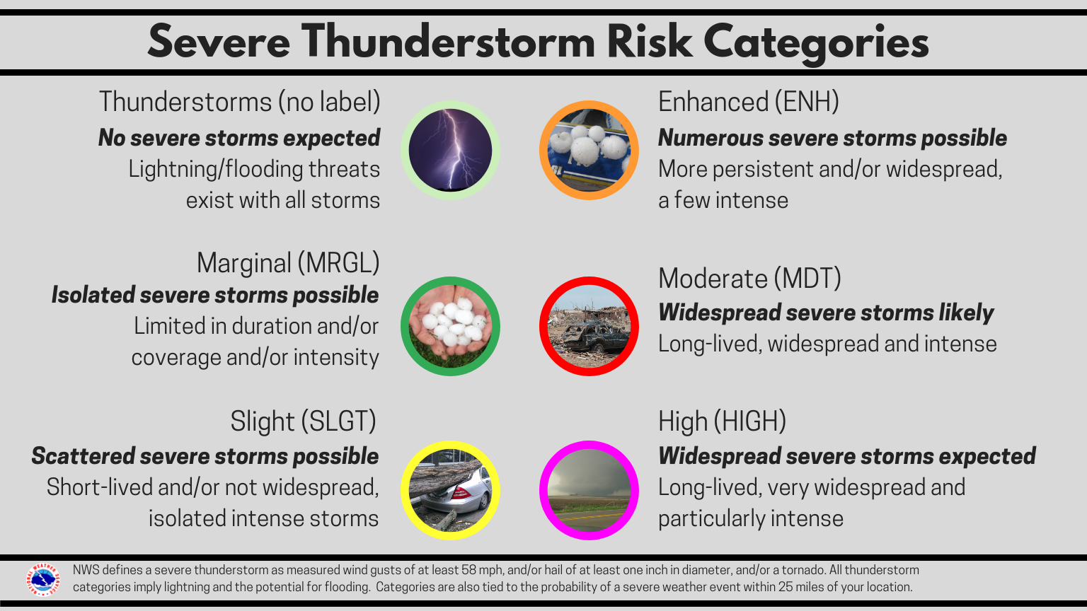
A thunderstorm is a local storm that produces lightning and thunder. Thunderstorms are often accompanied by showery rain and gusty winds, and may also bring hail or snow. Thunderstorms occur most frequently during the spring and summer, but they are also possible in the fall and winter. North Carolina experiences about 40 to 50 thunderstorm days per year. About 10 percent of thunderstorms are classified as severe – one that produces hail at least an inch in diameter, has winds of 58 miles per hour or stronger, or produces a tornado.
Tornadoes are nature’s most violent storms. Spawned from powerful thunderstorms, tornadoes can cause fatalities and devastate a neighborhood in seconds. A tornado appears as a rotating, funnel-shaped cloud that extends from a thunderstorm to the ground with whirling winds that can reach 300 miles per hour. Damage paths can be in excess of one mile wide and 50 miles long. Some tornadoes are clearly visible, while rain or nearby low-hanging clouds obscure others. Sometimes, tornadoes develop so rapidly that little, if any, advance warning is possible.
Severe Thunderstorms and Tornadoes Infographics
 |
 |
 |
 |
 |
 |
Did You Know Their Are Different Types of Tornadoes?

Tuesday
Receiving Severe Weather Alerts/Tornado Drill Information
Public Information Statement Day 3 (good for more detailed text)
***On Wednesday, March 10th at 9:30 AM, the National Weather Service will conduct a statewide tornado drill***
The alarm test, which will come in the form of a Required Monthly Test, will activate the State Emergency Alert System and be carried by local radio broadcasters. Every school, business, and residence is encouraged to participate in this drill. It’s really easy: at 9:30 AM on Wednesday, take a few moments to practice your severe weather safety plan, and seek shelter for a few minutes as if a tornado was headed your way.
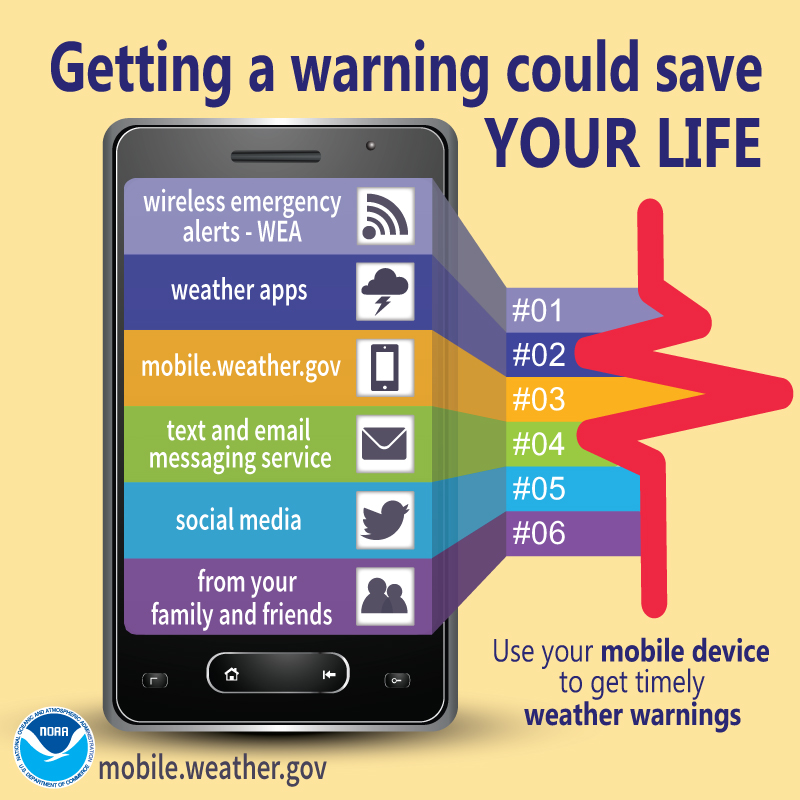
One of the keys to staying safe during the severe weather season is making sure that you have a way to receive lifesaving severe weather watches and warnings. There are many methods and tools, some of which are available with no cost or fees, that you can use to receive these important lifesaving alerts no matter where you are - at home, at school, or at work.
| Day of The Week | Topics |
|---|---|
| NOAA Weather Radio (NWR) | NWR is a nationwide network of radio stations broadcasting continuous weather information from the nearest National Weather Service office. Specially built receivers, which can be purchased at most electronics and large retail stores for less than $40, receive the NWR broadcast 24 hours a day, 7 days a week, and sound an audible alert when official watches and warnings are issued for your area. Think of these radios as a “smoke detector” for severe weather alerts. |
| Wireless Emergency Alerts (WEA) | With WEA, emergency alerts can be sent to your cell phone or mobile device when you may be in harm's way, without need to download an app or subscribe to a service. In addition to other alert types such as AMBER Alerts, this free service will transmit extreme weather warnings such as Tornado and Flash Flood warnings to your cell phone. The alerts will look like a text message, and will typically show the type and time of the alert, any action you should take. WEA messages include a special tone and vibration. If you receive a WEA message, you should follow any action advised by the emergency message. Seek more details from your favorite TV or radio station, NOAA Weather Radio, news website, desktop application, mobile application, or other trusted source of information. |
| Cell phone apps | There are many great cell phone apps that provide real-time NWS warnings and alerts, some of which are free to download and use, and others that may charge a small fee. A simple search of your app provider will reveal many of these apps. |
| Emergency Alert System (EAS) and your favorite TV and radio stations | EAS is the message dissemination pathway that sends warnings via broadcast, cable, satellite, and wireline services. EAS may be used by state and local authorities, including the National Weather Service, in cooperation with the broadcast community, to deliver important emergency information such as severe weather information, AMBER alerts, and local incident information targeted to specific areas. In short, when severe weather strikes, it’s a good idea to tune to your favorite local TV or radio station or web site for detailed information about the severe weather threat. |
In addition to the aforementioned alerting system, many communities also offer free emergency alert notifications through their own systems, such as reverse 911 phone systems. Be sure to check with your local emergency management agency to learn what is available in your area.
Receiving Severe Weather Alerts Infographics
 |
 |
 |
 |
Wednesday
High Winds/Hail/Tornadoes
Public Information Statement Day 4 (good for more detailed text)
|
|
|
|
|
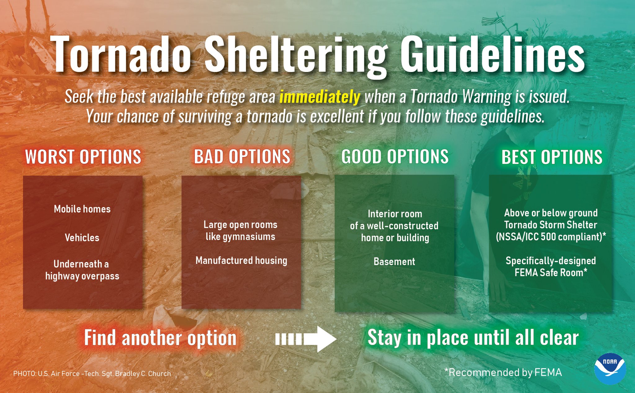
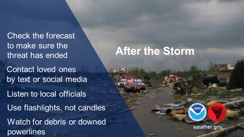
When your area is under a tornado warning, or if you see a tornado approaching, you should seek shelter immediately! Most injuries associated with high winds are from flying debris, so remember to protect your head. The following are safety tips for seeking shelter during high winds and tornadoes.
Tornado Safety Rules:
If you are in a home or small business:
Go to the basement or a small interior room such as a closet, bathroom or interior hallway without windows on the lowest level. Put as many walls between yourself and the outside as possible. If possible, get under something sturdy, such as a heavy table, or use a mattress to protect yourself from flying debris. Most injuries associated with high winds are from flying debris, so remember to protect your head. If available, put on a bicycle or motorcycle helmet to protect yourself from head injuries.
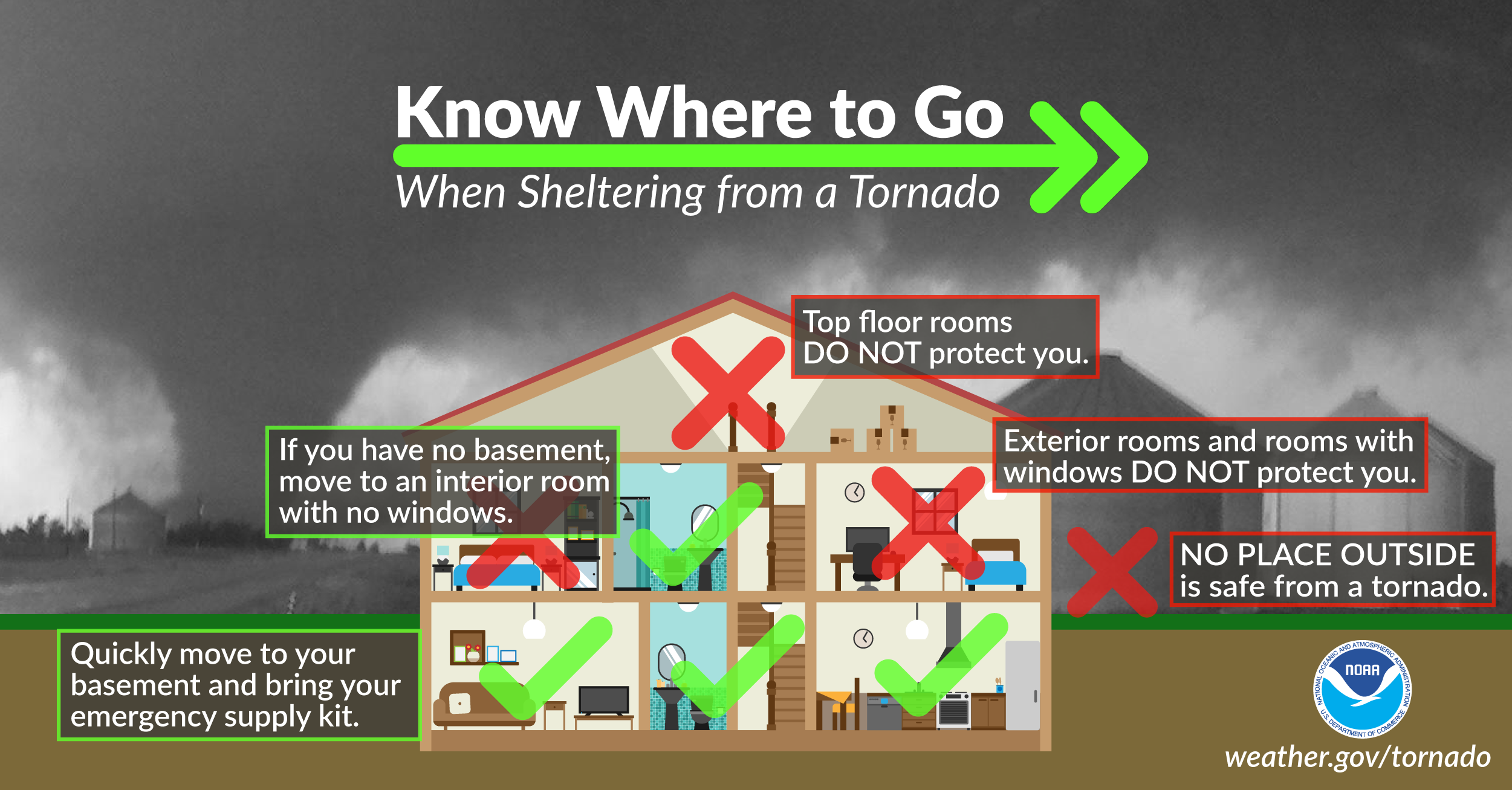
If you are in a large business, school, hospital, shopping center or factory:
Go to the designated shelter area. If a shelter area is not available, the best place is to go to an interior hallway on the lowest level. Stay away from the structurally weaker portions of buildings, such as windows and rooms with expansive roofs, which are more likely to collapse when tornadoes strike.
If you are in a mobile home or home on stilts:
Get out and take shelter in a sturdy building or storm shelter. If there is not one nearby, take shelter in the most interior room that has no windows, such as an interior bathroom or closet.
 |
 |
 |
If you are outside with no shelter available, there is no single research-based recommendation for what last-resort action to take, because many factors can affect your decision. Possible actions include:
While hail and straight-line winds generally do not garner the same attention or respect as tornadoes, they can be just as deadly! Hail can exceed the size of softballs and fall at speeds of over 100 mph, seriously injuring or killing anyone in its path. Straight-line winds can topple trees onto cars, houses, and power lines. Many deaths from straight-line winds are the result of trees falling onto the person, whether they are outside, in their house, or driving in their car. Strong straight-line wind events can even destroy buildings, especially mobile homes and manufactured homes.
High Winds, Hail, Tornadoes Infographics
 |
.png) |
 |
.png) |
.png) |
 |
Thursday
Lightning Safety
Public Information Statement Day 5 (good for more detailed text)
Each year in the United States, more than 400 people are struck by lightning. On average, between 55 and 60 people are killed; hundreds of others suffer permanent neurological disabilities. Most of these tragedies can be avoided with a few simple precautions. When thunderstorms threaten, get to a safe place. Lightning safety is an inconvenience that can save your life.
All thunderstorms produce lightning and are dangerous. Lightning often strikes outside the area of heavy rain and may strike as far as 10 miles from any rainfall. Many lightning deaths occur ahead of storms or after storms have seemingly passed. Keep this simple fact in mind: if you can hear thunder, you are in danger. Also, don’t be fooled by blue skies. There is no such thing as “heat lightning.” All lightning comes as a result of a thunderstorm, and if you hear thunder, lightning is close enough to pose an immediate threat to you.
The most effective lightning safety action can be found in avoiding the lightning threat altogether. Have a lightning safety plan. If you have outdoor plans, know where you’ll go for safety and how much time it will take to get there. Make sure your plan allows enough time to reach safety. Before going outdoors, check the forecast for thunderstorms. If thunderstorms are in the forecast, consider postponing activities to avoid being caught in a dangerous situation. Finally, when outdoors, monitor the weather and be sure to look for signs of a developing thunderstorm such as darkening skies, flashes of lightning, or increasing wind. If you hear thunder, even a distant rumble, immediately activate your lightning safety plan and move to a safe place.
For more information about safety, please visit http://www.lightningsafety.noaa.gov.
The following lightning safety tips could one day save your life:
 |
Lightning Infographics
 |
 |
 |
 |
 |
 |
Did You Know Their Are Different Types of Lightning?
.png)
Friday
Flash Flood Safety
Public Information Statement Day 6 (good for more detailed text)
Flash flooding in North Carolina usually occurs when a large amount of rain falls in an area over a short period of time. The ground can only soak up so much water in a given time, and when the rain rate exceeds what can infiltrate into the ground or run off into drainage systems or streams, flooding is likely to occur. Hurricanes, tropical storms, and ordinary thunderstorms can produce flash flooding.
More people die from floods each year than from tornadoes, lightning, or hurricanes. Forecasters can usually predict where flooding will occur when a hurricane or tropical storm affects an area. However, when dealing with thunderstorms, predicting flash floods can be nearly impossible due to their isolated nature. Flash floods usually occur in low-lying areas where water can collect or in cities where water runoff from impermeable surfaces can fill roads or storm drains quickly.
In the past 10 years, flash flooding has occurred in North Carolina over 1000 times, amounting to damages on the order of hundreds of millions of dollars, and resulting in numerous fatalities. Being prepared and knowing how to stay safe will help you and your loved ones survive a flood. Prepare now by visiting http://www.floodsafety.noaa.gov.
Remember these flash flood safety tips:
Flooding Infographics
.png) |
.png) |
.png) |
.png) |
.png) |
.png) |
Saturday
Making A Plan
Public Information Statement Day 7 (good for more detailed text)
The first step in making sure that you and your family are prepared for severe weather is pledging to prepare. This includes developing a family emergency and communications plan. In short, know what to do before severe weather strikes by creating an emergency plan today. Visit https://www.ready.gov/plan to make your plan today!
Your family may not be together when a disaster strikes, so it is important to plan in advance: how you will get to a safe place; how you will contact one another; how you will get back together; and what you will do in different situations.
Planning for severe weather also includes…
Making A Plan Infographics
 |
 |
 |
.png) |
Find us on social media:
You can also contact:
Erik Heden (Erik.Heden@noaa.gov) for additional information about Severe Weather Preparedness.


 Youtube
 Map View
 Weather Hazard Briefing (when applicable)
 Forecaster Discussion
 Marine
 Text Products
.png) Skywarn
Skywarn Submit Storm Reports
 Coastal Flood
.png) Surf Forecast/Rip Currents
Surf Forecast/Rip Currents