National Radar Loop April 12th (858 PM) to April 13th (7:38 PM)
|
|
Storm Reports Map For May 13th (click to enlarge)
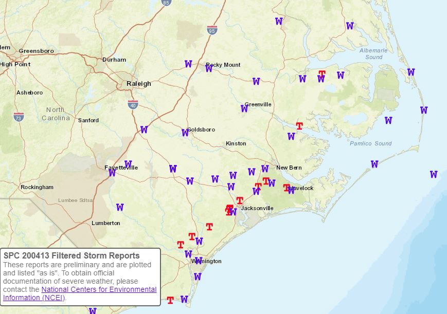
 Start Location...Haws Run in Onslow County NC
Beginning Lat/Lon...34.681143/-77.237818
Ending Lat/Lon...34.740172/-77.566916
Summary
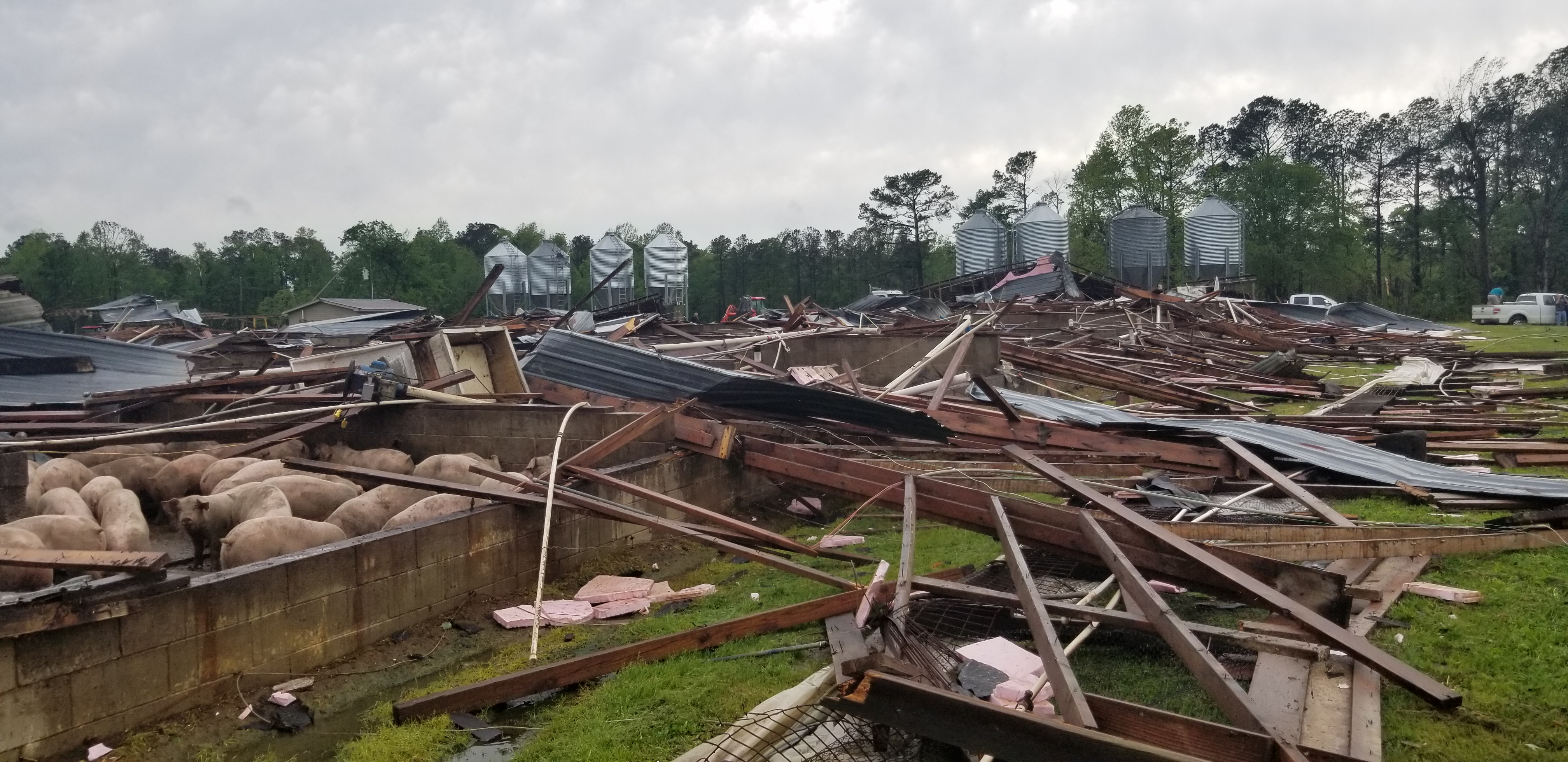
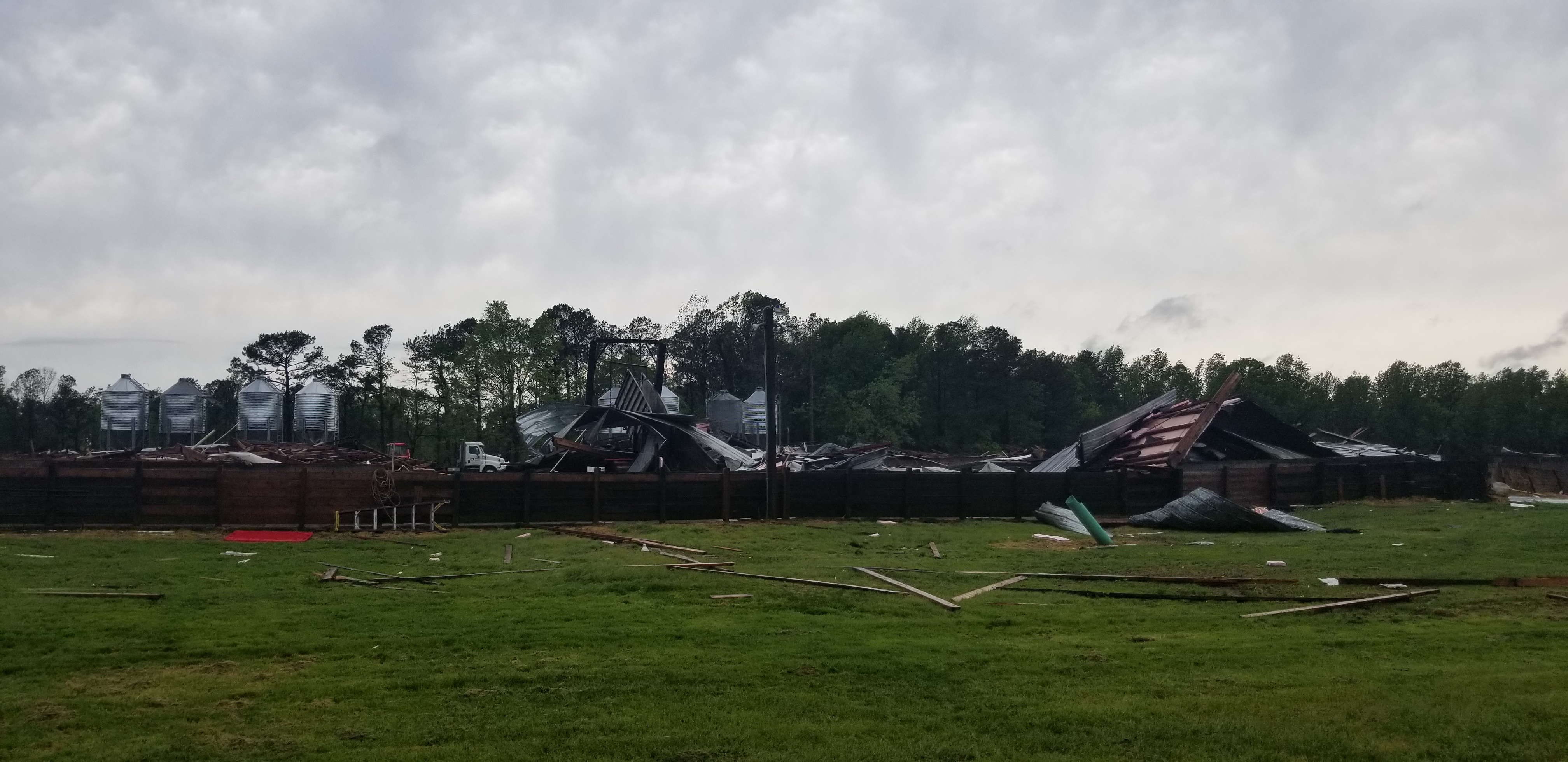
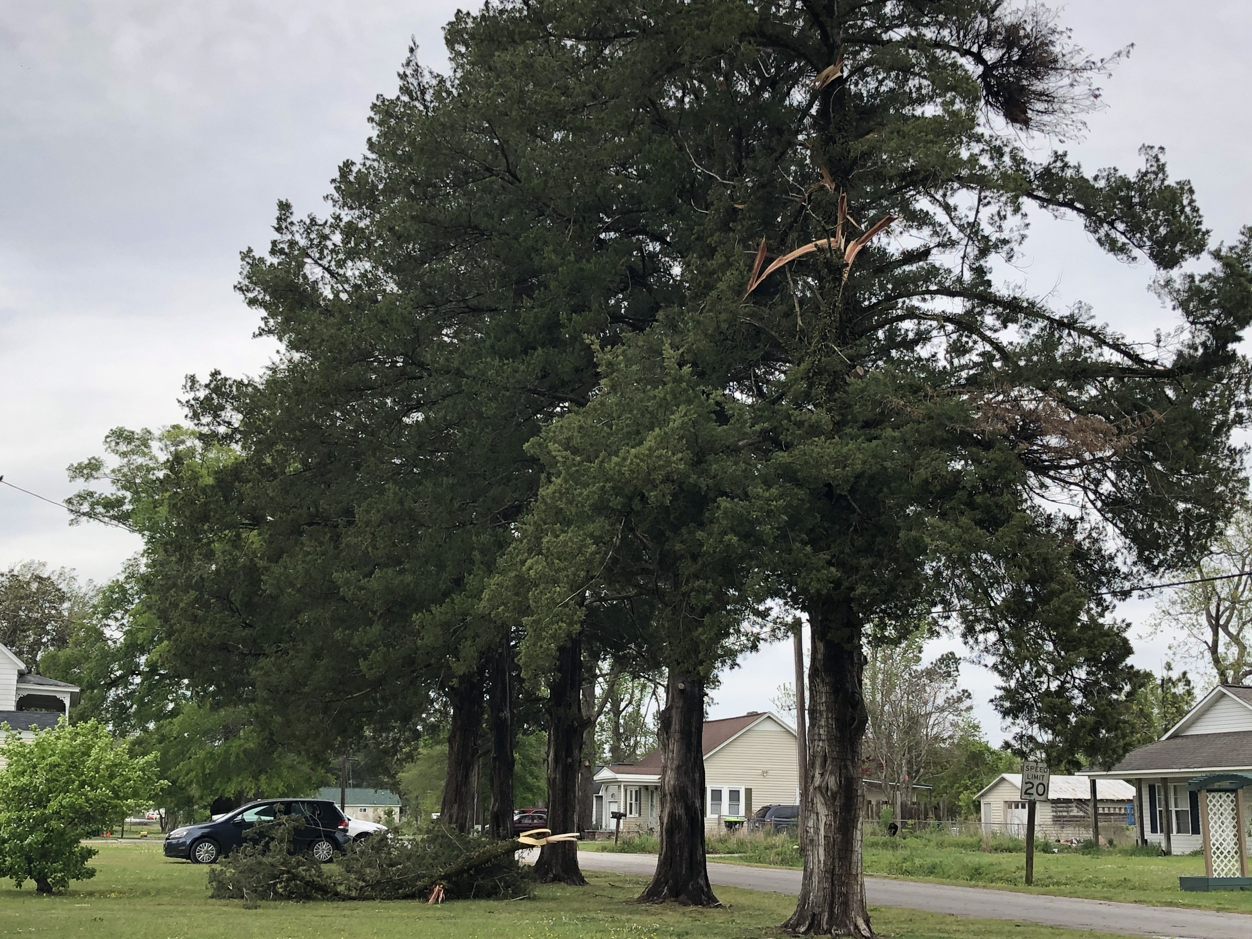
An EF-1 tornado with maximum wind speeds of 100 to 110 mph touched down in the in the Haws Run area of Onslow County approximately 10 miles southwest of Jacksonville around 9:30 AM. The damage path began along Haws Run Road, about 4 miles north of NC Highway 50, and mostly paralleled the road as it produced damage moving northeast. The tornado maintained mostly consistent strength throughout its path, though there were sections where the tornado briefly lifted and damage was more sporadic and less severe. In the most concentrated areas of damage there were numerous mature softwood and hardwood trees snapped at the trunk,uprooted, and twisted/splintered. This included several large limbs or trees that had fallen on top of manufactured homes. Perhaps the most pronounced damage occurred at a hog farm where the hog houses were completely destroyed, with many sections of the metal roof and insulation thrown up to several miles away from the farm. From there the tornado moved through a small residential neighborhood producing continued widespread tree damage, reaching its end point shortly thereafter just past the intersection of NC Highway 53 and Murrill Hill Road.
Radar Loops
Pictures
 |
 |
 |
 |
 |
 |
EF-0 Confirmed Tornado in Maysville
 Start Location...Maysville in Jones County North Carolina
Summary
The damage path started along and just east of Highway 17 in the town of Maysville, NC. The path consisted mainly of very small limbs and leaves and continued to the northeast. At the intersection of Jenkins Avenue and 4th Street a large section of a tree was blown down. Here top winds were estimated to be between 60 and 65 MPH. A broken path continued to the northeast across Highway 58, through the north side of Maysville. Some smaller limbs and leaf debris was found near 3rd street at the Baptist Church. The path continued to the northeast before crossing into the Croatan Forest.
Most of the damage along the path was minor, consisting of leaf litter and smaller limbs, consistent with winds of 50 to 55 mph. While the damage was minor, the concentrated path along with some convergence,shown by damage blown toward the northwest or opposite of the storm motion, was indicative of a weak tornado.
Radar imagery suggested the tornado may have strengthened once in the open forest. Future surveys may be needed and adjustments are possible.
Radar Loops
Pictures
 |
 |
 |
EF-0 Confirmed Tornado 5 Miles Southeast of Pollocksville
 Start Location...5 SE Pollocksville in Jones County NC
Summary
The damage path started along Catfish Farm Road, just south of the intersection with Mill Creek Road and about 5 miles southeast of Pollocksville or about 2.5 miles northwest of Catfish Lake in Jones County. In a heavily wooded area, a narrow but convergent path was found. The damage consisted mainly of smaller trees with a total of 10 to 15 trees that had broken larger limbs or were snapped. While most of the snapped trees were small, two large and healthy pine trees were snapped. It was here that maximum winds were estimated at between 75 and 80 mph, an equivalent of an EF0 tornado.
It should be noted that this is likely a continuation of the Maysville tornado. Due to the heavily wooded and unreachable areas between Maysville and this location, a continuous path could not be found. In addition it is likely the path length is longer than what is indicated above but areas to the northeast of this area were unreachable by vehicle. This likely concludes the survey for this location unless aerial information is available at a later date.
Radar Loops
Pictures
 |
 |
 |
EF-0 Confirmed Tornado in Havelock
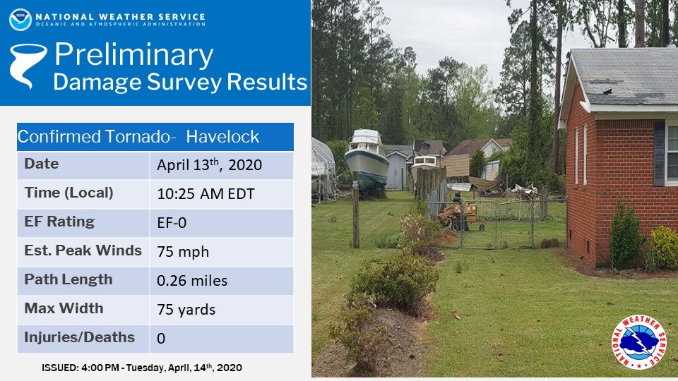 Start Location...Havelock in Craven County NC
Summary
NWS storm survey found damage to trees and fences, and some minor roof and aluminum carport damage in Havelock, NC, indicative of an EF0 tornado. The damage was localized around Greenway Court, Pinecone Lane, and Melody Lane in a residential neighborhood east of highway 70 on the northwest side of Havelock. Maximum sustained winds were estimated at 75 mph. The tornado had a path length of roughly one quarter mile, with a maximum path width of 75 yards. No injuries or fatalities occurred with this tornado.
Radar Loops
Pictures
 |
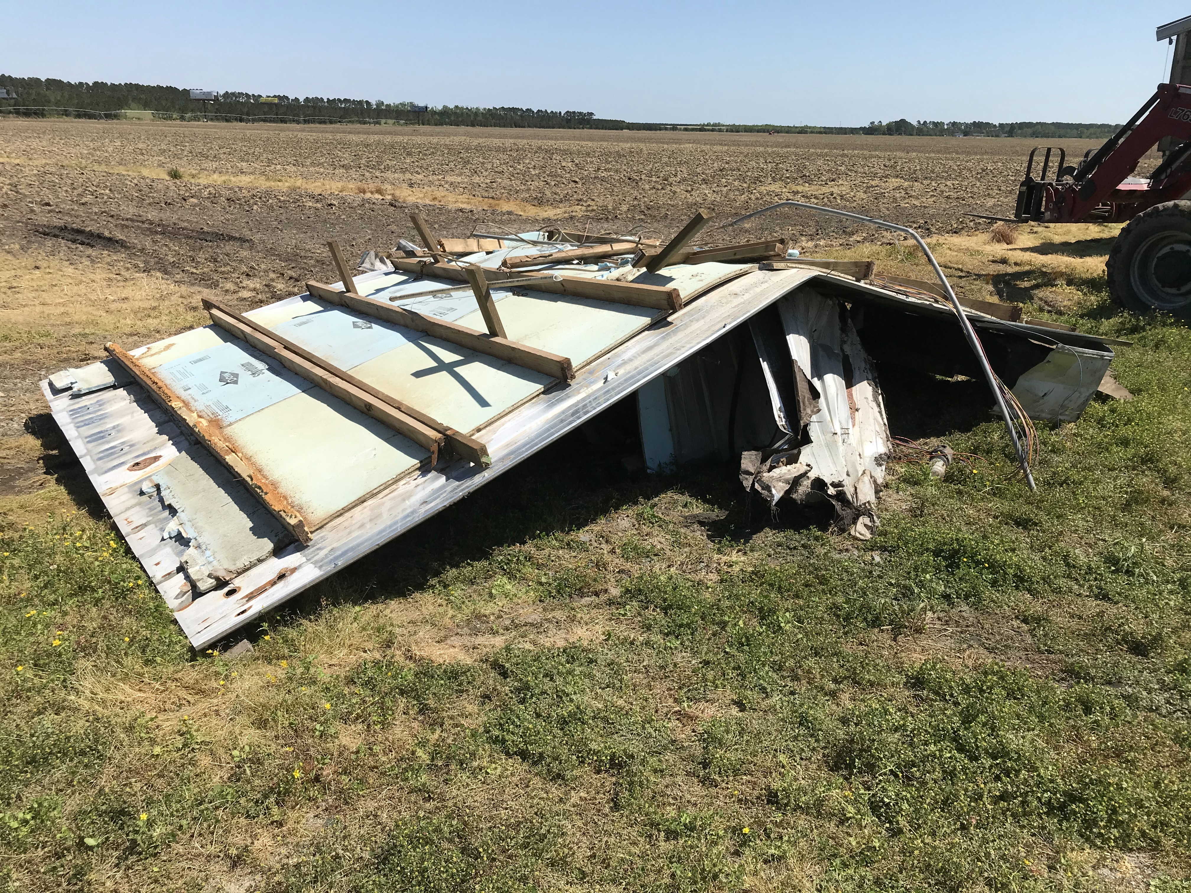
EF-0 Confirmed Tornado in Roper
 Start Location...3 E of Roper in Washington County NC
Summary
A brief tornado touched down near the town of Roper, NC, very near exit 548 just south of Highway 64. The tornado destroyed a hog farm building of Summerset Farms, just off of Northline Rd. The metal truss of the building was completely removed, and thrown into the adjacent farm field with the debris path extending 0.40 miles northeastward to the edge of Highway 64. Most of the debris consisted of metal sheet roofing. The damage was consistent with EF0 tornado damage.
Radar Loops
Pictures
 |
 |
 |
EF-0 Confirmed Tornado in Bayview
 Start Location...Bayview in Beaufort County NC
Summary
A brief tornado formed initially as a waterspout in the Pamlico River and came ashore in the town of Bayview, NC near Berkley Rd. The tornado tossed a boat off its lift, damaging the pier nearby before it became submerged in the river. Traveling northeast, it uprooted and snapped a few softwood pine trees and broke off multiple large branches, landing on a nearby home damaging it. The tornado then crossed Ormond Rd into a trailer park where, luckily, only a few large shrubs, small branches,and a cable line were destroyed. The damage was consistent with EF0 tornado damage.
Radar Loops
Pictures
 |
 |
 |
For reference:
EF Scale: The Enhanced Fujita Scale classifies tornadoes into the following categories:
| EF0 | Weak | 65 to 85 mph |
| EF1 | Weak | 86 to 110 mph |
| EF2 | Strong | 111 to 135 mph |
| EF3 | Strong | 136 to 165 mph |
| EF4 | Violent | 166 to 200 mph |
| EF5 | Violent | >200 mph |
A microburst is a convective downdraft with an affected outflow area of less than 2 1/2 miles wide and peak winds lasting less than 5 minutes. Microbursts may induce dangerous horizontal/vertical wind shears, which can adversely affect aircraft performance and cause property damage. Straight-line winds are generally any wind that is not associated with rotation, used mainly to differentiate them from tornadic winds.
Additional Information:
Radar Links:


 Map View
 Weather Hazard Briefing (when applicable)
 Forecaster Discussion
 Marine
 Text Products
.png) Skywarn
Skywarn Submit Storm Reports
 Coastal Flood
.png) Surf Forecast/Rip Currents
Surf Forecast/Rip Currents