Highway 12 ("S" Turns) Just north of Rodanthe (11/8/2021). Credit NC DOT NC12.
While Tropical Cyclones grab most of the headlines in Eastern North Carolina, coastal low pressure systems occurring in the cool season can be just as impactful, bringing strong winds, coastal flooding, and heavy rains to the Outer Banks, Crystal Coast and low-lying inland areas along the various sounds, rivers, and creeks that make coastal North Carolina such a unique place. Locals often refer to these coastal storms as "mullet blows" or use the term "sharks are in the collards" to describe the flooding this time of year.
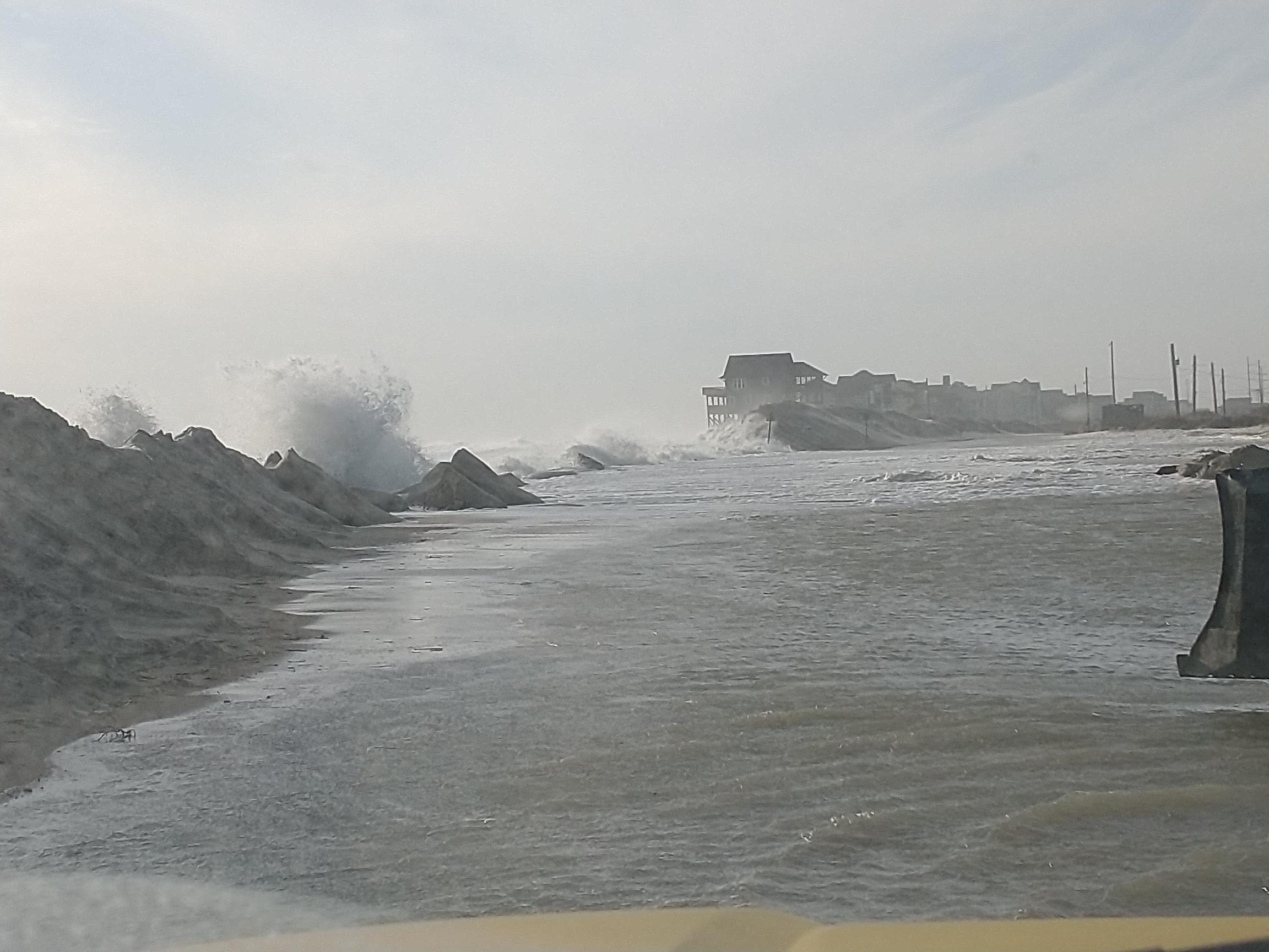
The coastal low forming off of the North Carolina Coast resulted in many of these impacts coming to fruition on the weekend of November 6-7th, 2021 causing considerable ocean overwash of the dunes that protect NC Highway 12 along the Outer Banks. This resulted in moderate to major coastal flooding including the closing of the highway which quickly became impassable. Many other locations along the Outer Banks and mainland coastal counties experienced varying degrees of coastal flooding, made worse by coincident timing with the “King Tides”, the name given to the highest lunar tide cycles of the year.
In addition to the coastal flooding, High winds with gusts over 60 mph were recorded in some locations with storm force gusts observed over the water at some buoy locations. Strong winds, while inconvenient over land, really led to some treacherous marine conditions accompanied by seas of 15-20 feet in some locations, and while the low pressure moved further offshore, its influence remained on the coastal waters for several days as seas remained above small craft advisory criteria.
While the impacts were typical of what is commonly seen during a winter time coastal low in Eastern North Carolina, several factors increased the degree of difficulty on the forecast for this system. The first of which was that the system developed off of the southeast coast, the genesis of which was not handled well by forecast models. As opposed to a mature system that can be tracked for several days, a storm forming and deepening off of the coast is very hard to pin down details such as where the low will exactly form, how quickly it will develop and how strong will the pressure drop be, all of which have implications for how the eventual impacts will play out on land.
One area of the forecast that was especially difficult to pin down was the rainfall forecast. In addition to not knowing how far offshore the low would eventually form, a strong, almost 1030 mb high pressure system over the Appalachians and northeastern U.S. was acting as a barrier to keep precipitation pinned to the coast. Forecast models were predicting as much as 6 inches of rain a few days before but in reality, the low formed a bit further offshore than expected and realized rainfall totals only amounted to about a half of an inch with lesser amounts inland.
That same high pressure that helped limit some of the rainfall totals also played a role in strengthening the pressure gradient between the developing low, which minimum pressure wise was not all that strong, and the surface high which helped with some of the higher wind speed values that were observed. As the low strengthened offshore, the pressure gradient continued to contribute to gusty winds and high seas for the next couple of days.
Finally, despite the “King Tides”, total water forecasts were extremely accurate realizing the moderate to major flooding expected several forecast cycles in advance, allowing forecasters to brief emergency managers several days before the event occurred with the correct level of impact realized.
Coastal Flooding
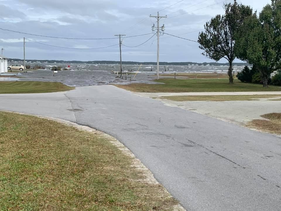
Coastal flooding can be a frequent occurrence along the coast of North Carolina. Early November of 2021 provided an excellent example of how other factors can combine with a storm, to produce major impacts. The flooding was caused by three different factors: 1) Certain periods of the year we have higher than normal astronomical tides. These higher tides can cause flooding even absent of other weather factors and often are referred to as "sunny day" flooding or the "king tides". These higher tides caused elevated water levels as early as the 4th of November and continued through the 8th. 2) During the same time period, a persistent north to northeast wind occurred. This prolonged intensity and similar wind direction caused water levels to increase and enhanced the effect of the already higher than normal tides. 3) Lastly, during this same period an area of low pressure moved out of the Gulf of America and across Florida, before intensifying well off the North Carolina coastline. The combination of this coastal low and the pressure gradient between it and high pressure to the north, enhanced the winds on Saturday the 6th into Sunday the 7th.
Below are some weather related graphs and information. Please see the videos and pictures tab for more on the impacts.

The above gauge at Duck shows that major flood stage (6.5 feet MLLW) was exceeded through multiple high tide cycles. High water levels combined with breaking waves and wave run up on the beaches, breached dunes along Highway 12 north of Rodanthe causing Highway 12 to be closed for 3 days. The peak value of 6.87 feet (MLLW) was the 4th all time highest value at Duck and the 2nd highest value in a non tropical event.

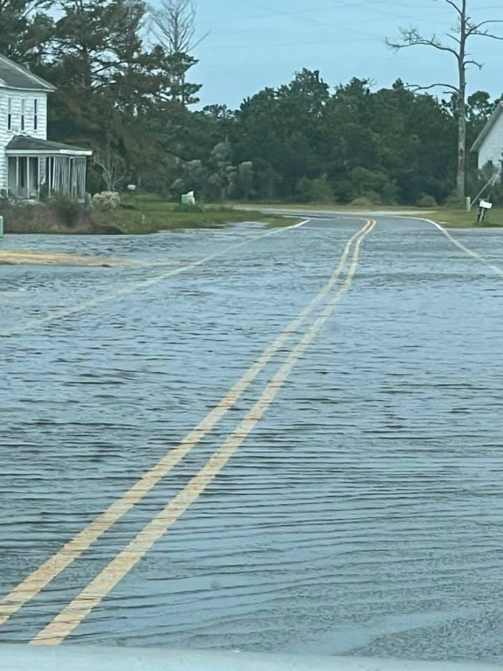
The above gauge at Beaufort shows that minor coastal flooding occurred multiple high tide cycles starting on November 6th and lasting through November 8th. Water was observed during these high tides in Downtown Morehead city along Sheperd Street between 9th and 12th streets. Downtown Beaufort also saw some water on the east end of Front Street near Gerald Street. Roads were also closed on Harkers Island, Marshallberg, and Atlantic Beach due to high water.

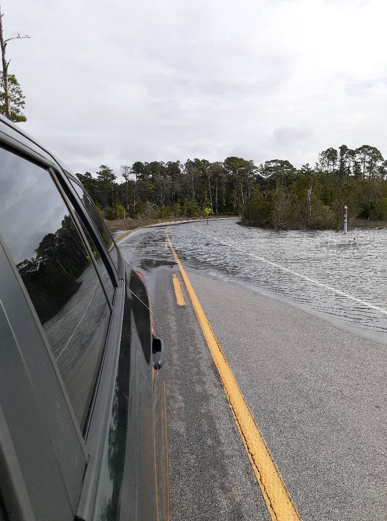
The above gauge at Cedar Island shows minor flooding occurred over multiple days. This flooding was due to strong and persistent north to northeast winds over multiple days blowing over the large expanse of the Pamlico Sound. Water was across Highway 12 prior to Cedar Island. Enough roads were covered with water by Monday morning the 8th, that schools across Downeast Carteret County were closed.


Flooding also occurred at the eastern end of the Pamlico Sound as north to northeast winds pilled up water from the Pamlico Sound. In addition to flooding from the ocean, soundside flooding occurred on Ocracoke Island, especially Sunday morning when winds reached their peak.

Some minor soundside flooding was reported Sunday the 8th in Hatteras Village and in Frisco.
PRELIMINARY LOCAL STORM REPORT...SUMMARY
NATIONAL WEATHER SERVICE NEWPORT/MOREHEAD CITY NC
1205 PM EST TUE NOV 9 2021

..TIME...   ...EVENT...      ...CITY LOCATION...     ...LAT.LON...
..DATE...   ....MAG....      ..COUNTY LOCATION..ST.. ...SOURCE....
            ..REMARKS..

0814 PM     COASTAL FLOOD    1 E BUXTON              35.27N 75.52W
11/06/2021                   DARE               NC   LAW ENFORCEMENT

            OVER-WASH COVERING HWY 12 IN THE AREA OF
            CAPE HATTERAS MOTEL IN BUXTON FLOWING ACROSS
            THE ROAD AT A HIGH RATE OF SPEED.

0757 AM     COASTAL FLOOD    3 NNW ATLANTIC          34.93N 76.36W
11/07/2021                   CARTERET           NC   PUBLIC

            WATER COVERS SECTIONS OF HIGHWAY 12 TOWARD
            CEDAR ISLAND.

0939 AM     COASTAL FLOOD    3 SSE OREGON INLET      35.75N 75.51W
11/07/2021                   DARE               NC   DEPT OF HIGHWAYS

            NC DOT REPORTING HWY 12 CLOSED BETWEEN
            RODANTHE AND MARC BASNIGHT BRIDGE. ROAD
            COVERED WITH WATER AS AM HIGH TIDE BREACHED
            DUNE.

1028 AM     COASTAL FLOOD    1 WNW HARKERS ISLAND    34.70N 76.58W
11/07/2021                   CARTERET           NC   PUBLIC

            WATER SURROUNDING SOME HOMES ON ISLAND ROAD.
            WATER ALSO ACROSS OLD FERRY DOCK ROAD,
            MAKING IT IMPASSABLE NEAR THE WATERFRONT.

1030 AM     COASTAL FLOOD    1 S BEAUFORT            34.71N 76.65W
11/07/2021                   CARTERET           NC   PUBLIC

            WATER COVERING FRONT STREET NEAR
            INTERSECTION OF GERALD STREET MAKING IT
            IMPASSABLE IN SECTIONS. WATER INTO THE EDGES
            OF SOME YARDS ALONG FRONT STREET.

1040 AM     COASTAL FLOOD    3 SE SNEADS FERRY       34.53N 77.35W
11/07/2021                   ONSLOW             NC   PUBLIC

            RIVER ROAD IMPASSABLE DUE TO HIGH WATER.
            PICTURES ALSO SHOWED WATER UP PAST DOCKS AND
            INTO THE LAWNS OF ADJACENT PROPERTIES ALONG
            THE WATER IN NORTH TOPSAIL BEACH.

1129 AM     COASTAL FLOOD    SEALEVEL                34.87N 76.38W
11/07/2021                   CARTERET           NC   PUBLIC

            CORRECTS PREVIOUS COASTAL FLOOD REPORT FROM
            SEALEVEL. HIGH WATER MAKING ROADS
            IMPASSABLE, SURROUNDING SOME HOMES. CEDAR
            CREEK CAMPGROUNDS HAS WATER THROUGHOUT THE
            CAMPGROUND.

1129 AM     COASTAL FLOOD    1 ENE INDIAN BEACH      34.69N 76.89W
11/07/2021                   CARTERET           NC   PUBLIC

            WATER SURROUNDS THE CRAB SHACK. WATER
            HALFWAY UP THE ROAD TO THE SALTER PATH
            UNITED METHODIST CHURCH.

1130 AM     COASTAL FLOOD    3 SSE HARLOWE           34.80N 76.72W
11/07/2021                   CARTERET           NC   PUBLIC

            MINOR STREET FLOODING DUE TO COASTAL
            FLOODING. WATER LEVEL APPROXIMATELY 3.5 FEET
            ABOVE NORMAL.

1149 AM     COASTAL FLOOD    1 NNW GLOUCESTER        34.74N 76.55W
11/07/2021                   CARTERET           NC   PUBLIC

            WATER COVERS PORTIONS OF STRAITS ROAD.

1201 PM     COASTAL FLOOD    2 ESE HARKERS ISLAND    34.69N 76.53W
11/07/2021                   CARTERET           NC   PUBLIC

            ISLAND ROAD FLOODED BETWEEN STACY ROAD AND
            SHELDON ROAD.

1244 PM     COASTAL FLOOD    2 ESE HARKERS ISLAND    34.69N 76.53W
11/07/2021                   CARTERET           NC   PARK/FOREST SRVC

            PARTS OF CAPE LOOKOUT NATIONAL SEASHORE
            FLOODING INCLUDING THE WAITING AREA, PARKING
            LOT NEAR THE BOAT BASIN, BOAST BASIN, MAIN
            ENTRANCE ROAD, AND THE HARKERS ISLAND
            VISITOR CENTER.

0133 PM     COASTAL FLOOD    1 NE FRISCO             35.24N 75.62W
11/07/2021                   DARE               NC   PUBLIC

            WATER OVER ROADWAY ON HWY 12.

0200 PM     COASTAL FLOOD    1 NNW SNEADS FERRY      34.56N 77.38W
11/07/2021                   ONSLOW             NC   PUBLIC

            FULCHER LANDING LOOP ROAD IMPASSABLE DUE TO
            HIGH WATER, NEAR EXTREME WATERSPORTS AND THE
            NC WILDLIFE BOAT LANDING.

0800 AM     COASTAL FLOOD    3 SSE OREGON INLET      35.76N 75.51W
11/08/2021                   DARE               NC   DEPT OF HIGHWAYS

            NC DOT REPORTING HWY 12 CLOSED BETWEEN
            RODANTHE AND MARC BASNIGHT BRIDGE. ROAD
            COVERED WITH WATER AS WATER BREACHED DUNE.

1041 AM     COASTAL FLOOD    ATLANTIC BEACH          34.70N 76.74W
11/08/2021                   CARTERET           NC   NWS EMPLOYEE

            PONDING ON THE MAIN ROAD AND WIDESPREAD
            FLOODING IN THE PARKING LOTS.

1111 AM     COASTAL FLOOD    4 SSE OREGON INLET      35.74N 75.50W
11/08/2021                   DARE               NC   DEPT OF HIGHWAYS

            SEVERE OVERWASH WITH DUNES COMPRISED
            RESULTING IN HWY 12 BEING CLOSED PER NCDOT.
            DUCK BUOY CRESTED AT 6.87 FEET SUNDAY
            MORNING MAKING IT THE 4TH HIGHEST ON RECORD.
            IT WAS THE SECOND HIGHEST NON TROPICAL CREST
            LEVEL.

1136 AM     COASTAL FLOOD    1 NW MARSHALLBERG       34.73N 76.52W
11/08/2021                   CARTERET           NC   PUBLIC

            WATER COVERING STAR CHURCH ROAD AT HIGH
            TIDE.

1137 AM     COASTAL FLOOD    1 ESE MOREHEAD CITY     34.72N 76.72W
11/08/2021                   CARTERET           NC   PUBLIC

            WATER COVERING SHEPARD STREET BETWEEN 9TH
            AND 12 STREETS. THE ROAD IS IMPASSABLE IN
            SPOTS, WITH SOME WATER SURROUNDING HOMES.

0434 PM     COASTAL FLOOD    1 SSW DAVIS             34.79N 76.46W
11/08/2021                   CARTERET           NC   PUBLIC

            HIGH WATER ON MURPHY ROAD IN DAVIS.


&&

$$

HEDEN
&&
|
Wind Reports

Tropical storm force gusts (39 MPH or higher) were common especially along coastal areas. The strongest winds occurred from the Crystal Coast of Carteret County through the Outer Banks.
000 NOUS42 KMHX 081021 PNSMHX NCZ029-044>047-079>081-090>092-094-193>196-198-199-203>205-082209- PUBLIC INFORMATION STATEMENT NATIONAL WEATHER SERVICE NEWPORT/MOREHEAD CITY NC 509 AM EST MON NOV 8 2021 ...HIGHEST WIND REPORTS SINCE SATURDAY MORNING... LOCATION SPEED TIME/DATE PROVIDER ...NORTH CAROLINA... ...BEAUFORT COUNTY... WASHINGTON (OCW AWOS) 36 MPH 1115 AM 11/07 AWOS ...CARTERET COUNTY... FORT MACON (WXFLOW) 62 MPH 1255 AM 11/07 WXFLOW BEAUFORT 48 MPH 0446 PM 11/07 CWOP CAPE LOOKOUT 48 MPH 1100 PM 11/06 NDBC PINEY ISLAND (NBT AWOS) 47 MPH 0137 PM 11/07 AWOS BEAUFORT (MRH ASOS) 45 MPH 1128 AM 11/07 ASOS BEAUFORT (DUKE MARINE LAB) 44 MPH 0324 PM 11/07 NOS-NWLON ATLANTIC BEACH 0.4 E 41 MPH 0146 AM 11/07 CWOP BOGUE FIELD (NJM ASOS) 39 MPH 0241 PM 11/07 AWOS CROATAN RAWS 37 MPH 0505 PM 11/07 RAWS NEWPORT 6.4 SW 36 MPH 0530 AM 11/07 CWOP CEDAR ISLAND RAWS 34 MPH 0525 AM 11/07 RAWS EMERALD ISLE 3 WSW 32 MPH 0439 PM 11/07 CWOP MOREHEAD CITY 4.7 W 31 MPH 1245 PM 11/07 CWOP NEWPORT 7.5 E 30 MPH 1125 AM 11/07 CWOP ...CRAVEN COUNTY... CHERRY POINT (NKT ASOS) 39 MPH 0940 AM 11/07 AWOS NEW BERN (EWN ASOS) 37 MPH 0955 AM 11/07 ASOS NEW BERN RAWS 30 MPH 0117 PM 11/06 RAWS ...DARE COUNTY... AVON (WXFLOW) 64 MPH 0717 PM 11/06 WXFLOW OREGON INLET (WXFLOW) 64 MPH 0506 PM 11/07 WXFLOW OREGON INLET CG (WXFLOW) 60 MPH 0325 PM 11/07 WXFLOW REAL SLICK (WXFLOW) 53 MPH 0554 PM 11/07 WXFLOW NAGS HEAD 52 MPH 0426 PM 11/07 CWOP BUXTON (WXFLOW) 51 MPH 0634 PM 11/07 WXFLOW KHK RESORT (WXFLOW) 51 MPH 0519 PM 11/07 WXFLOW MANTEO (MQI AWOS) 49 MPH 1135 AM 11/07 AWOS RODANTHE 0.6 N 48 MPH 0715 PM 11/07 CWOP OREGON INLET MARINA 48 MPH 0418 PM 11/07 NOS-NWLON HATTERAS HIGH (WXFLOW) 48 MPH 0314 PM 11/07 WXFLOW FRISCO 0.3 SW 47 MPH 0200 PM 11/07 CWOP BUXTON 44 MPH 0330 PM 11/07 RAWS DARE CO GNRY RAN (2DP AWOS) 43 MPH 0549 PM 11/07 AWOS BUXTON 0.7 SE 42 MPH 0230 PM 11/07 CWOP FRISCO (HSE ASOS) 41 MPH 0201 PM 11/07 ASOS SOUTHERN SHORES 1.7 NNW 40 MPH 0525 PM 11/07 CWOP KILL DEVIL HILLS (FFA AWOS) 39 MPH 0355 PM 11/07 AWOS DARE BOMB RANGE RAWS 39 MPH 0528 PM 11/07 RAWS ...HYDE COUNTY... FAIRFIELD RAWS 34 MPH 0517 PM 11/07 RAWS ...LENOIR COUNTY... KINSTON (ISO AWOS) 35 MPH 0856 AM 11/07 AWOS ...ONSLOW COUNTY... SNEADS FERRY 1.7 SE 39 MPH 1145 AM 11/07 CWOP JACKSONVILLE (NCA ASOS) 39 MPH 0928 AM 11/07 AWOS JACKSONVILLE 1.7 NNW 33 MPH 0826 AM 11/07 CWOP RICHLANDS (OAJ AWOS) 33 MPH 0643 PM 11/06 AWOS ...PAMLICO COUNTY... ORIENTAL 1.7 NE 35 MPH 0215 PM 11/07 CWOP ...PITT COUNTY... GREENVILLE (PGV AWOS) 31 MPH 0115 PM 11/07 AWOS GREENVILLE (DOWDY FICKLEN ST 30 MPH 1250 PM 11/07 MESOWEST ...WASHINGTON COUNTY... ROPER 9.8 ENE 32 MPH 0830 PM 11/06 CWOP TIDEWATER RESEARCH STATION 30 MPH 0335 PM 11/07 NC-ECONET ...MARITIME STATIONS... JENNETTES PIER (WXFLOW) 72 MPH 0325 PM 11/07 WXFLOW ONSLOW BAY BUOY (41064) 67 MPH 1208 AM 11/07 NDBC ALLIGATOR RIVER BR (WXFLOW) 58 MPH 0339 PM 11/07 WXFLOW DIAMOND BUOY (41025) 56 MPH 0600 PM 11/07 NDBC AVON SOUNDSIDE (WXFLOW) 53 MPH 0323 PM 11/07 WXFLOW PAMLICO SOUND (WXFLOW) 52 MPH 0351 PM 11/07 WXFLOW OCRACOKE (WXFLOW) 50 MPH 0503 PM 11/07 WXFLOW ROANOKE SOUND CHANNEL 50 MPH 0609 PM 11/07 WXFLOW DUCK PIER 48 MPH 0554 PM 11/07 NOS-NWLON NORTH RIVER 47 MPH 1010 AM 11/07 WXFLOW CROATAN SOUND 45 MPH 0253 PM 11/07 WXFLOW && OBSERVATIONS ARE COLLECTED FROM A VARIETY OF SOURCES WITH VARYING EQUIPMENT AND EXPOSURES. WE THANK ALL VOLUNTEER WEATHER OBSERVERS FOR THEIR DEDICATION. NOT ALL DATA LISTED ARE CONSIDERED OFFICIAL. $$ && && |
Videos
Ocean Overwash Buxton, NC
November 8th, 2021
Credit: Altitude 12
Ocean Overwash Rodanthe, NC "S" Curves
November 8th, 2021
Credit: Altitude 12
Ocean Overwash Avon, NC
November 8th, 2021
Credit: Altitude 12
Pictures
November 7th Pictures
|
Harkers Island. Old Ferry Dock Road. Credit: Aprille Gillikin |

Harkers Island Credit: Aprille Gillikin. |

Harkers Island Credit: Aprille Gillikin. |
|
Sneads Ferry. Fultcher Landing Loop Road. Credit: Tim Supple |

Salter Path. Credit: Crab Shack |

Salter Path. Credit: Crab Shack |
|
Cedar Island. Highway 12 Credit: Jessica Lee Emory |
Straits. Straits Road. Credit: Debra Nelson Willis |
Cedar Island. Highway 12 Credit: Jessica Lee Emory |
Waves

The Diamond Shoals buoy is located less than 20 miles off from Cape Point on Hatteras Island. Waves peaked at around 16 feet on the evening of the 6th (Friday night).

The Onslow Bay buoy is located well off the Crystal Coast. Waves peaked at around 16 feet on the evening of the 6th (Friday night) into early Saturday morning (7th).

The buoy above is located off Oregon Inlet. Waves peaked at around 17 feet on the evening of the 7th (Sunday night) into early morning Monday morning (8th).
Preparedness
***Check back for more soon***


.jpg)

.png) Surf Forecast/Rip Currents
Surf Forecast/Rip Currents Tropical Weather
 Map View
 Weather Hazard Briefing (when applicable)
 Forecaster Discussion
 Marine
 Text Products
.png) Skywarn
Skywarn Submit Storm Reports