
National Weather Service Office, Newport, NC. January 22nd, 2022.
The winter storm of January 21st - 22nd, 2022 will go down as a memorable ice storm, especially for areas from near Jacksonville to Cape Carteret, Maysville, Morehead City, Newport and Oriental. In these areas between .25" and .50" of ice fell (freezing rain), the most widespread and heaviest icing since at least the late 90s (when our office opened in this area). An ICE Storm WARNING was issued by our office for the first time ever. Farther north a wintry mix of sleet and snow produced a general 1" to 4" of snow, with some isolated higher totals. Mainly rain fell on the Outer Banks, but from Manteo and Nags Head north, up to 2" of snow fell.
Scroll through the event using these tabs to learn more.
Ice Reports
The most significant aspect of this storm was the amount of icing. While most of the area saw at least a bit of icing, or at least some sleet, the significant icing occurred in a stripe from southeast Duplin County east through Onslow, southern Jones, Carteret, southern Craven, and Pamlico Counties. The map below shows icing ranged from a quarter to as much as one half inch in these areas. In addition to freezing rain, most of these areas also saw periods of sleet. Bridges were closed for a time with scattered power outages. Read more in the impacts section.


Ice covered sign outside our upper air building. NWS Newport Office.
PRELIMINARY LOCAL STORM REPORT...SUMMARY
NATIONAL WEATHER SERVICE NEWPORT/MOREHEAD CITY NC
554 PM EST SUN JAN 23 2022

..TIME...   ...EVENT...      ...CITY LOCATION...     ...LAT.LON...
..DATE...   ....MAG....      ..COUNTY LOCATION..ST.. ...SOURCE....
            ..REMARKS..

0635 PM     ICE STORM        1 SW JACKSONVILLE       34.75N 77.42W
01/21/2022                   ONSLOW             NC   EMERGENCY MNGR

            EMERGENCY MANAGEMENT REPORTING MULTIPLE
            COLLISIONS AND CRASHES DUE TO ICING OF
            ROADWAYS; ROADS AND BRIDGES FREEZING.

0716 PM     ICE STORM        1 N COASTAL CAROLINA RE 35.09N 77.04W
01/21/2022                   CRAVEN             NC   DEPT OF HIGHWAYS

            SOCIAL MEDIA REPORTS THAT THE TWIN SPAN AND
            NEUSE RIVER BRIDGES IN THE NEW BERN AREA ARE
            NOW CLOSED BY THE NC DOT DUE TO ROAD
            CONDITIONS.

0721 PM     ICE STORM        3 ESE HARLOWE           34.83N 76.69W
01/21/2022                   CARTERET           NC   UTILITY COMPANY

            CARTERET-CRAVEN ELECTRIC COOPERATIVE
            REPORTED TREES AND LIMBS ON POWERLINES.


0133 AM     ICE STORM        2 SW GREAT NECK         34.91N 76.70W
01/22/2022                   CRAVEN             NC   UTILITY COMPANY

            CARTERET-CRAVEN ELECTRIC COOPERATIVE
            REPORTED TREES AND LIMBS ON POWERLINES.

0145 AM     ICE STORM        1 WNW MOREHEAD CITY     34.73N 76.75W
01/22/2022                   CARTERET           NC   PUBLIC

            TREE LIMBS BREAKING DUE TO ICE ALONG 35TH
            STREET BEHIND THE HOSPITAL IN MOREHEAD CITY.


361
NOUS42 KMHX 232255
PNSMHX
NCZ029-044>047-079>081-090>092-094-193>196-198-199-203>205-241055-

PUBLIC INFORMATION STATEMENT
NATIONAL WEATHER SERVICE NEWPORT/MOREHEAD CITY NC
555 PM EST SUN JAN 23 2022

...FREEZING RAIN REPORTS...

LOCATION                     AMOUNT    TIME/DATE       PROVIDER

...NORTH CAROLINA...

...CARTERET COUNTY...
1 WSW NEWPORT                0.50 IN   0630 AM 01/22   PUBLIC
1 NNW MOREHEAD CITY          0.50 IN   0233 PM 01/22   PUBLIC
1 ESE MOREHEAD CITY          0.38 IN   1100 AM 01/22   TRAINED SPOTTER
1 WNW MOREHEAD CITY          0.35 IN   0629 AM 01/22   NWS EMPLOYEE
2 W NEWPORT                  0.30 IN   0800 AM 01/22   PUBLIC
1 W BOGUE                    0.30 IN   0833 AM 01/22   NWS EMPLOYEE
2 WSW NEWPORT                0.25 IN   0550 AM 01/22   NWS EMPLOYEE
2 WSW NORTH RIVER            0.20 IN   0800 AM 01/22   NWS EMPLOYEE
SMYRNA                       0.10 IN   0930 AM 01/22   PUBLIC
HARKERS ISLAND               0.10 IN   1200 PM 01/22   PUBLIC
2 S CEDAR ISLAND             0.10 IN   0235 PM 01/22   PUBLIC

...CRAVEN COUNTY...
2 SSW HAVELOCK               0.50 IN   1100 AM 01/22   PUBLIC
1 ENE NEUSE FOREST           0.25 IN   0757 AM 01/22   TRAINED SPOTTER
TRENT WOODS                   T IN     0830 AM 01/22   TRAINED SPOTTER

...DUPLIN COUNTY...
WALLACE                      0.25 IN   0936 AM 01/22   PUBLIC

...ONSLOW COUNTY...
2 SE RICHLANDS               0.50 IN   1230 AM 01/22   AMATEUR RADIO
2 NNE NORTH TOPSAIL BEACH    0.30 IN   0750 AM 01/22   TRAINED SPOTTER
1 NNE CAMP LEJEUNE CENTER    0.20 IN   0633 AM 01/22   PUBLIC
2 W SWANSBORO                0.20 IN   0700 AM 01/22   TRAINED SPOTTER

...PAMLICO COUNTY...
1 N MINNESOTT BEACH          0.30 IN   0800 AM 01/22   TRAINED SPOTTER
1 WNW ORIENTAL               0.30 IN   1100 AM 01/22   PUBLIC

...TYRRELL COUNTY...
COLUMBIA                     0.30 IN   1030 AM 01/22   TRAINED SPOTTER
2 N COLUMBIA                 0.20 IN   0800 AM 01/22   PUBLIC


&&
|
Snow Reports
While we certainly did not see a major accumulation of ice across our area, any amount is noteworthy for our area. The blue shaded area on the map below shows where we had a light glaze of ice, especially on road signs or trees. No ice was reported on major roads. The areas that did see some light icing Sunday morning quickly warmed up by mid morning with plain rain the rest of the event.


PUBLIC INFORMATION STATEMENT NATIONAL WEATHER SERVICE NEWPORT/MOREHEAD CITY NC 555 PM EST SUN JAN 23 2022 ...SNOWFALL REPORTS... LOCATION AMOUNT TIME/DATE PROVIDER ...NORTH CAROLINA... ...BEAUFORT COUNTY... CHOCOWINITY 4.5 IN 0720 AM 01/22 PUBLIC 1 ESE BLOUNTS CREEK 4.5 IN 1200 PM 01/22 PUBLIC WASHINGTON PARK 3.5 IN 0830 AM 01/22 TRAINED SPOTTER 3 NNW BATH 3.5 IN 0848 AM 01/22 CO-OP OBSERVER 1 N WASHINGTON 3.5 IN 1100 AM 01/22 PUBLIC PANTEGO 3.5 IN 0130 PM 01/22 TRAINED SPOTTER 3 NNE BUNYAN 3.0 IN 0924 AM 01/22 PUBLIC BATH 2.5 IN 0745 AM 01/22 PUBLIC AURORA 4.8 NE 0.5 IN 0700 AM 01/22 COCORAHS 3 WNW SOUTH CREEK 0.5 IN 0700 AM 01/22 PUBLIC ...CARTERET COUNTY... 1 W BOGUE 0.6 IN 0843 AM 01/22 NWS EMPLOYEE NEWPORT 0.2 SW 0.1 IN 0800 AM 01/22 COCORAHS NEWPORT 2.5 W T IN 0800 AM 01/22 COCORAHS ...CRAVEN COUNTY... 2 W VANCEBORO 4.5 IN 1000 AM 01/22 PUBLIC 1 N VANCEBORO 4.0 IN 0930 AM 01/22 PUBLIC TRENT WOODS 1.3 IN 0830 AM 01/22 TRAINED SPOTTER NEW BERN 8.8 W 1.0 IN 0700 AM 01/22 COCORAHS NEW BERN 5.3 SW 0.8 IN 0700 AM 01/22 COCORAHS NEW BERN 7.3 ESE 0.8 IN 0700 AM 01/22 COCORAHS NEW BERN 1.3 NNE 0.5 IN 0700 AM 01/22 COCORAHS TRENT WOODS 1.3 SSE 0.2 IN 0700 AM 01/22 COCORAHS PERRYTOWN (COOP) 0.2 IN 0800 AM 01/22 COOP HAVELOCK 1.9 SSE 0.1 IN 0637 AM 01/22 COCORAHS ...DARE COUNTY... SOUTHERN SHORES 2.0 IN 0924 AM 01/22 PUBLIC MANNS HARBOR 2.0 IN 0931 AM 01/22 TRAINED SPOTTER KITTY HAWK 2.0 IN 1100 AM 01/22 PUBLIC 1 NW MANTEO 1.5 IN 1000 AM 01/22 PUBLIC 1 WNW KITTY HAWK 1.0 IN 0720 AM 01/22 TRAINED SPOTTER ...DUPLIN COUNTY... 2 S FAISON 3.5 IN 0730 AM 01/22 TRAINED SPOTTER ALBERTSON 2.2 IN 0730 AM 01/22 PUBLIC ALBERTSON 2.0 IN 0730 AM 01/22 TRAINED SPOTTER 5 WSW MAGNOLIA 1.5 IN 0740 AM 01/22 ...GREENE COUNTY... HOOKERTON 0.5 ESE 4.0 IN 0700 AM 01/22 COCORAHS ...LENOIR COUNTY... KINSTON 5.1 WNW 4.5 IN 0700 AM 01/22 COCORAHS 4 SW KINSTON 4.5 IN 0715 AM 01/22 TRAINED SPOTTER LA GRANGE 3.3 IN 0630 AM 01/22 TRAINED SPOTTER 1 ESE KINSTON 3.0 IN 0526 AM 01/22 PUBLIC KINSTON 2.5 IN 0740 AM 01/22 TRAINED SPOTTER ...MARTIN COUNTY... WILLIAMSTON 4.0 IN 1216 PM 01/22 TRAINED SPOTTER ...ONSLOW COUNTY... ALBERT J ELLIS AIRPORT 1.0 IN 0519 AM 01/22 COUNTY OFFICIAL HUBERT 3.7 ENE 0.5 IN 0900 AM 01/22 COCORAHS SWANSBORO 1.4 N T IN 0830 AM 01/22 COCORAHS ...PITT COUNTY... 2 ENE FALKLAND 6.0 IN 0930 AM 01/22 PUBLIC 1 WSW FOUNTAIN 5.0 IN 0500 AM 01/22 PUBLIC 3 NW FALKLAND 4.5 IN 0815 AM 01/22 TRAINED SPOTTER FARMVILLE 3.1 NW 4.2 IN 0800 AM 01/22 COCORAHS GREENVILLE 7.1 SSE 4.0 IN 0654 AM 01/22 COCORAHS 1 SE WINTERVILLE 4.0 IN 0830 AM 01/22 TRAINED SPOTTER 1 SSW DOWDY FICKLEN STADIUM 3.9 IN 0822 AM 01/22 TRAINED SPOTTER GREENVILLE 5.7 NW 3.5 IN 0700 AM 01/22 COCORAHS GREENVILLE 2.0 SE 3.5 IN 0800 AM 01/22 COCORAHS WINTERVILLE 3.5 W 3.2 IN 0700 AM 01/22 COCORAHS GREENVILLE 5.0 SE 3.0 IN 0700 AM 01/22 COCORAHS 3 W GREENVILLE 3.0 IN 0830 AM 01/22 4 ESE WINTERVILLE 3.0 IN 0943 AM 01/22 TRAINED SPOTTER GREENVILLE 3.0 IN 1045 AM 01/22 TRAINED SPOTTER 2 NNE WINTERVILLE 2.8 IN 0921 AM 01/22 TRAINED SPOTTER FOUNTAIN 0.1 NE 2.6 IN 0700 AM 01/22 COCORAHS ...TYRRELL COUNTY... COLUMBIA 0.8 NNE 3.8 IN 0700 AM 01/22 COCORAHS COLUMBIA 3.8 IN 0743 AM 01/22 PUBLIC COLUMBIA 3.1 IN 1030 AM 01/22 PUBLIC GUM NECK (COOP) 1.0 IN 0700 AM 01/22 COOP ...WASHINGTON COUNTY... 1 WSW PLYMOUTH 5.0 IN 1129 AM 01/22 PUBLIC && |
Videos
As mentioned before our office in Newport experienced some of the highest icing totals in our area (.50"). Scroll down to view some videos taken from our office during the ice storm.
Newport, NC
January 22nd, 2022
Credit: National Weather Service
Newport, NC
January 22nd, 2022
Credit: National Weather Service
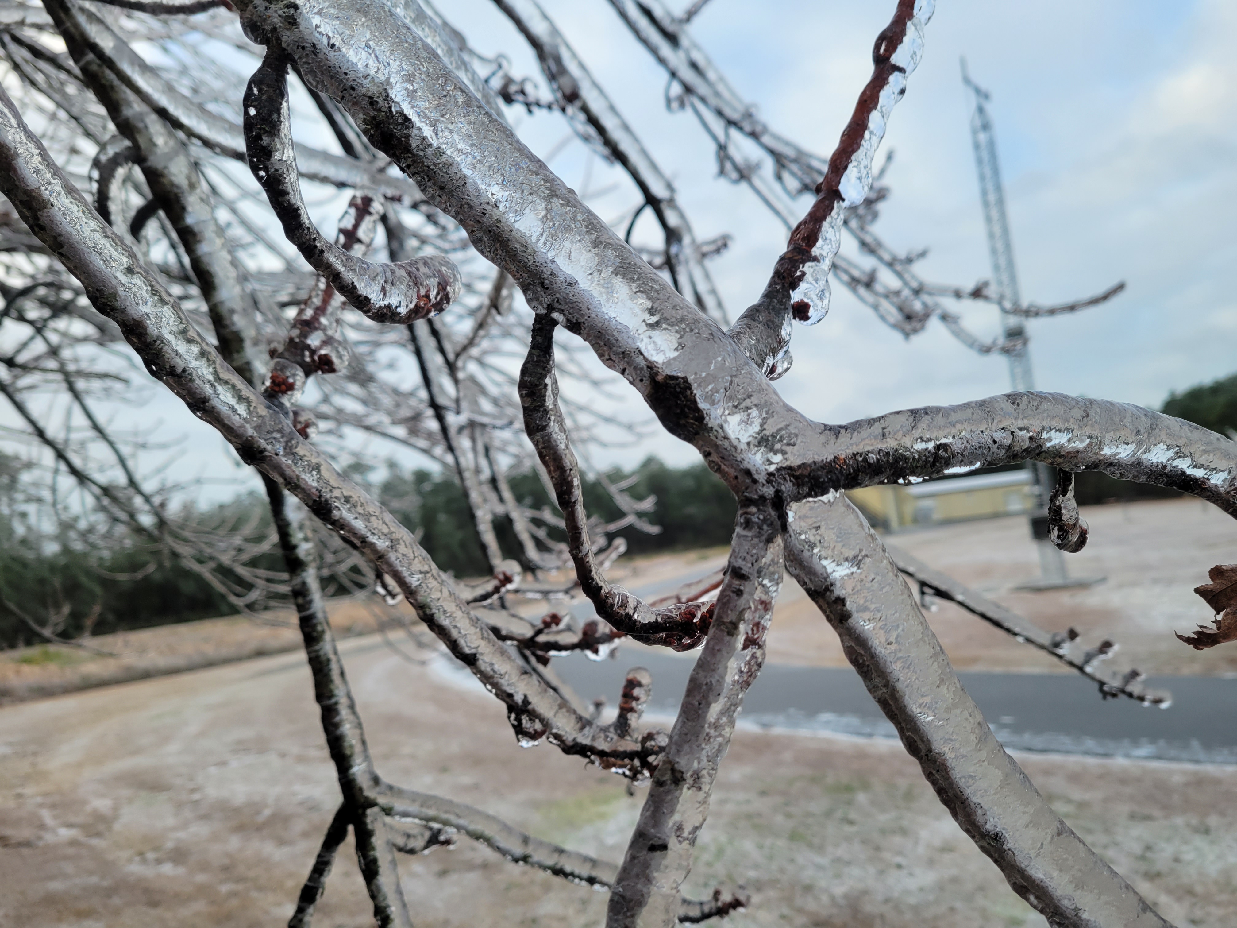
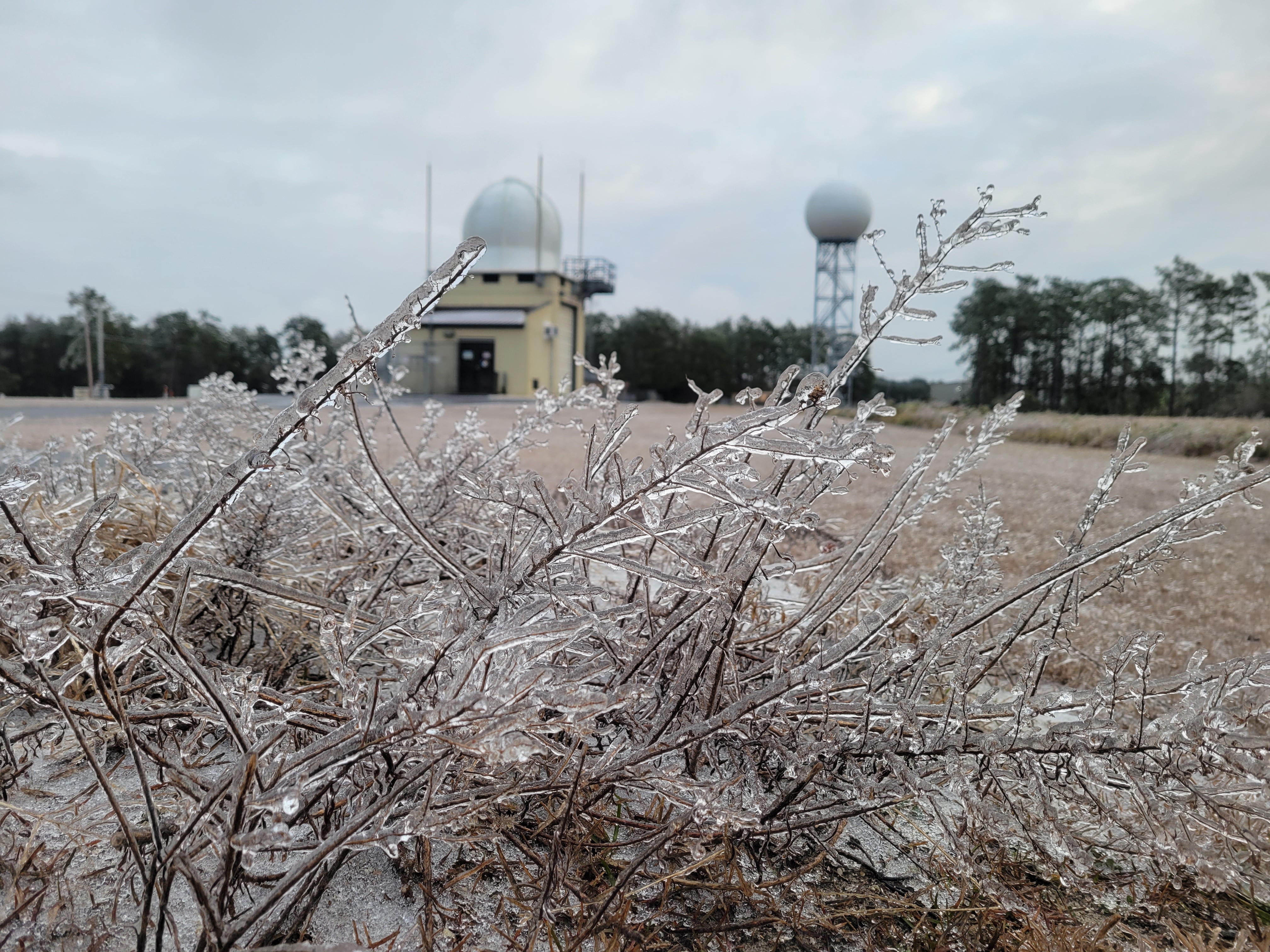
Pictures
The amount of ice across our area made for some beautiful pictures from across our area. Our office in Newport (just northwest of Morehead City, NC), experience .50" of ice. Scroll down for some pictures taken at our office on January 22nd, 2022.


Impacts
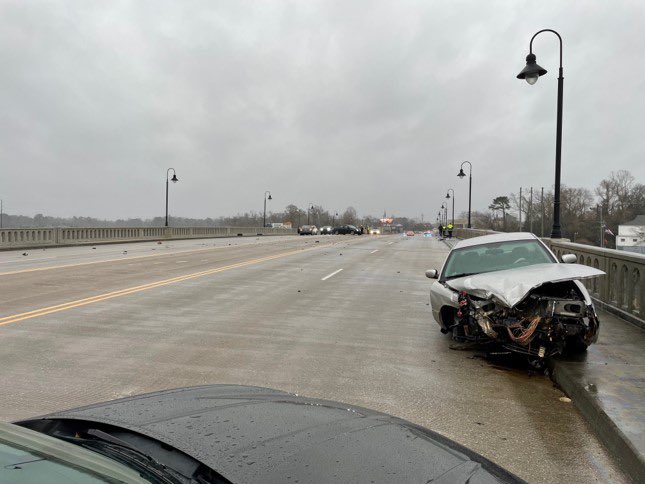
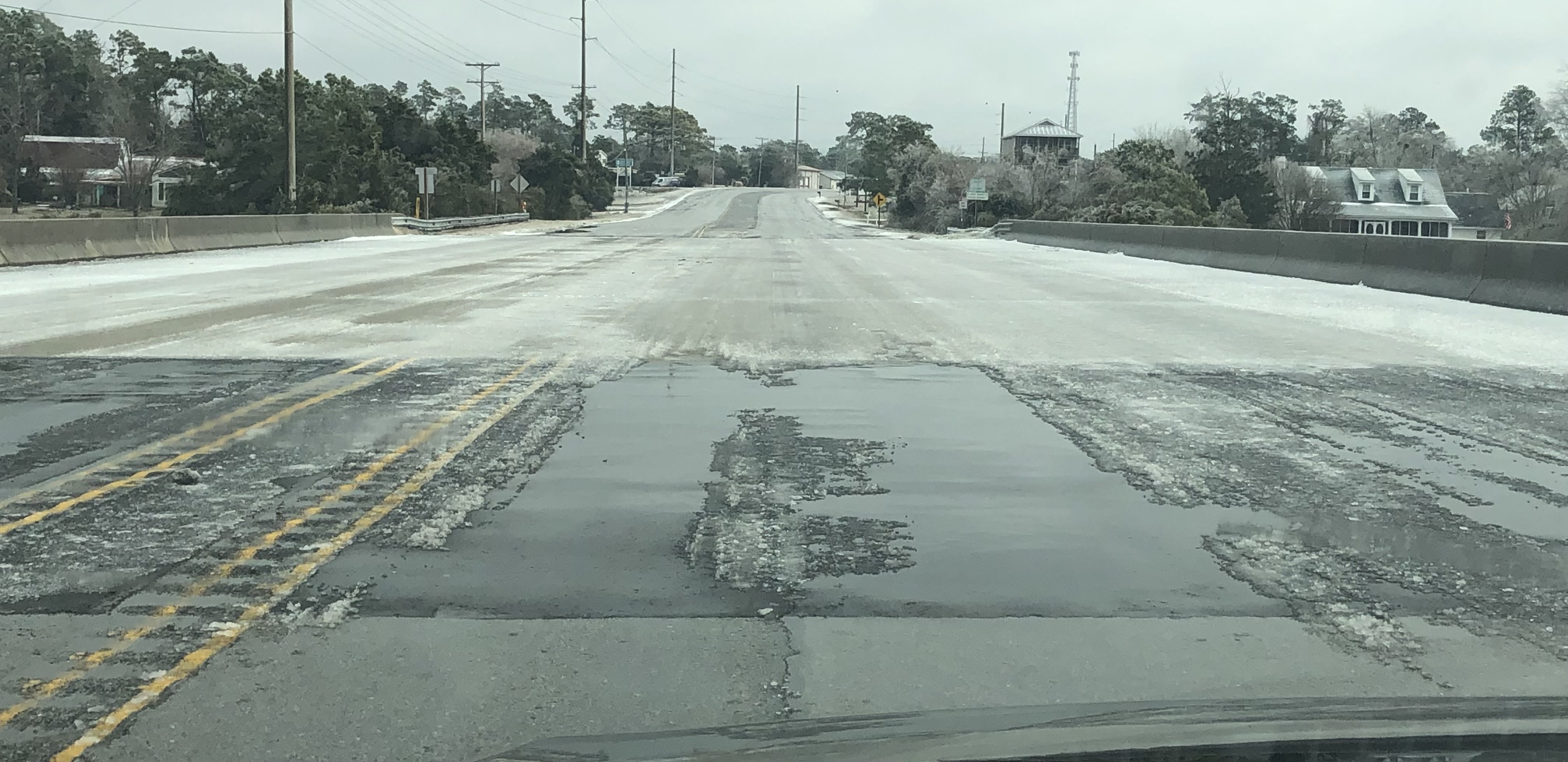
The most significant impacts were scattered power outages and hazardous roads Friday evening through Saturday. On Friday evening multipole bridges were closed in New Bern, Jacksonville and across the Morehead City area. Some bridges remained closed overnight due to severe icing on the bridges. Over 12,000 people lost power. Scroll down for some images of the icing on area bridges.
City of Jacksonville late Friday January 21st, 2022. Credit: City of Jacksonville.
Highway 24 between Cape Carteret and Morehead City. Broad Creek Bridge Around 11 AM. January 22nd, 2022.
Credit: Erik Heden.
Communication
A winter storm WATCH (winter storm conditions are possible) was issued for the area early morning on Wednesday January 19th), more than 60 hours before significant icing occurred. The following morning, these WATCHES were upgraded to Winter Storm WARNINGS and an Ice Storm WARNING. This is the first time our office has EVER issued an Ice Storm WARNING. These warnings were issued more than 36 hours before significant icing occurred.
Briefings and live weather updates (webinars) were conducted with core partners such as local Emergency Managers, DOT, Media, Schools, etc starting on Wednesday and lasting through Friday afternoon. A portion of these videos was posted to our YouTube Channel and shared on Facebook and Twitter. In addition these briefings were viewable by the general public on our website.
On Facebook, we held two Facebook Lives Thursday and Friday evening. While these served as an update on the storm, the main focus was preparedness.

Winter Storm Headlines Issued Thursday Morning (1/20/22). First time our office has issued a Ice Storm Warning.

An example of what information was shown in our briefings to core partners. In addition to a timeline of when to expect the worst weather, we highlighted ice and snow amounts, along with a focus on how the snow and ice may linger due to cold weather.

An example of a video update posted to our YouTube Channel. In total these were viewed over 5,000 times.

An example of Facebook Live. We held 2 of these prior to the storm (focus on storm preparedness) with 1 on the morning of the storm, to talk about how to measure snow and ice.


.png) Surf Forecast/Rip Currents
Surf Forecast/Rip Currents Tropical Weather
 Map View
 Weather Hazard Briefing (when applicable)
 Forecaster Discussion
 Marine
 Text Products
.png) Skywarn
Skywarn Submit Storm Reports