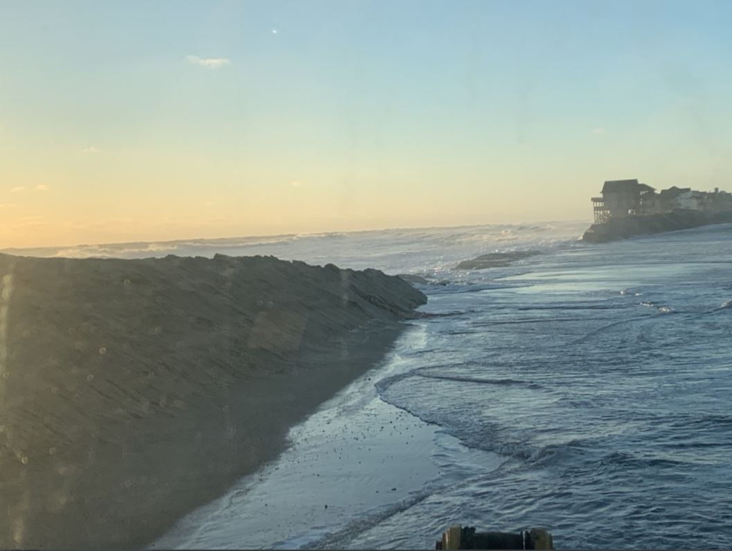
Highway 12 ("S" Turns/Mirlo Beach) Just north of Rodanthe (1/4/2022). Credit NC DOT NC12.
An intensifying area of low pressure moved across Eastern North Carolina on Monday January 3rd, bringing a variety of weather impacts to the area. This storm made national headlines producing 8" to 12" of snow across the Mid Atlantic States, stranding drivers on I-95 south of DC for more than 20 hours. Locally, we experienced a bit of everything, from heavy rain, gusty winds, and severe thunderstorms on the front end of the storm, to coastal flooding and even some snow farther inland!
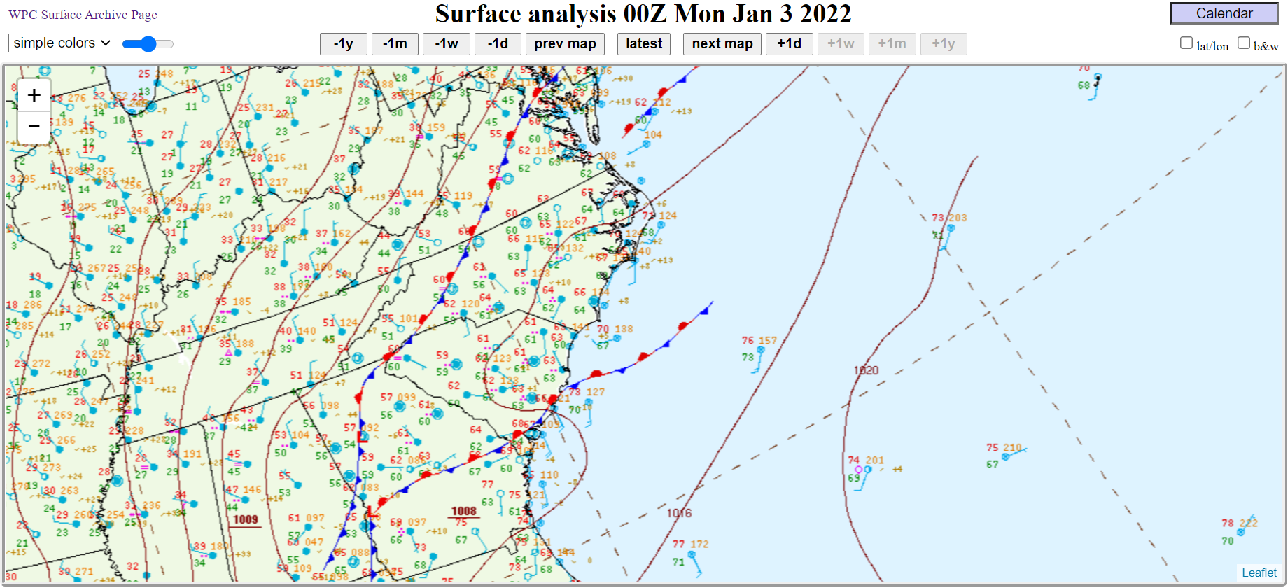
Initially, as an area of low pressure moved out of the Upstate of South Carolina and toward our area Monday morning, heavy rain, gusty winds, and severe thunderstorms were the main threats. With the low center approaching from the southwest, much of Eastern North Carolina was in the warm sector ahead of the system, with the threat for severe thunderstorms prompting the issuance of a Tornado WATCH Monday morning. A line of storms moved through Monday morning. These storms helped to mix down some stronger winds aloft, and we saw isolated areas of wind damage across the area. In addition, the strong south to southwest winds, combined with an already high tide cycle to produce flooding Monday morning across Beaufort and downtown Morehead City. In addition to the minor to moderate flooding levels, strong wind waves added to the severity of the coastal flooding along the northern shores of Bogue Sound, where several docks were damaged.
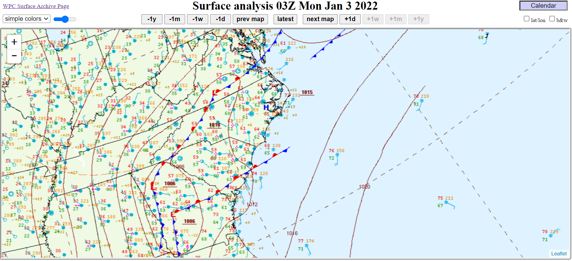
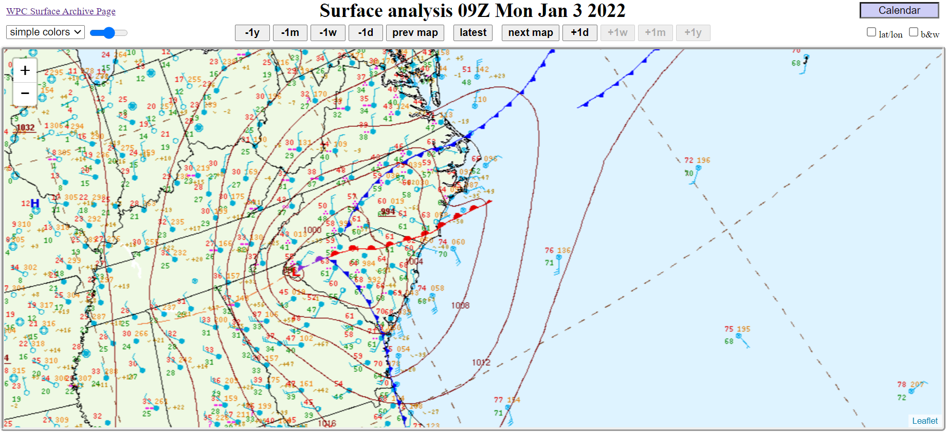
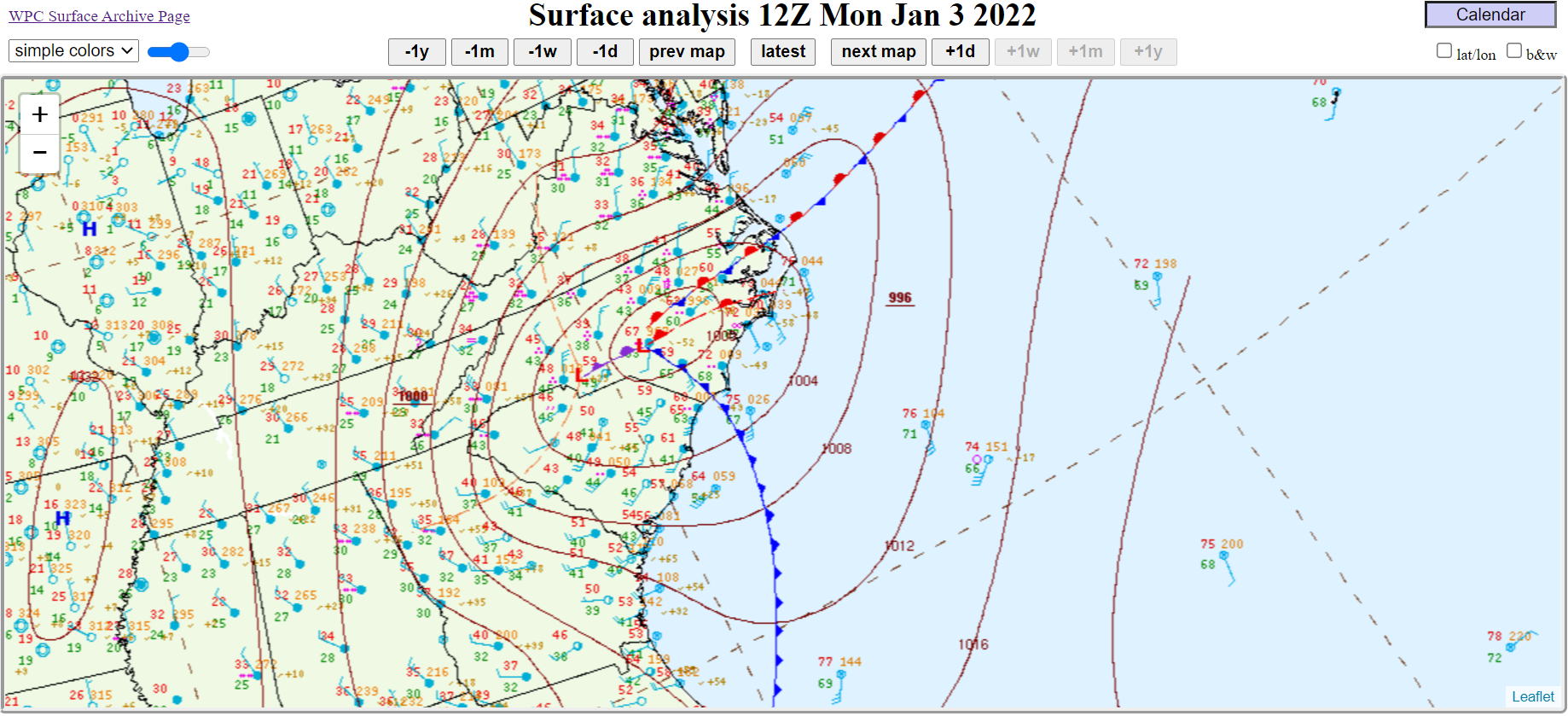
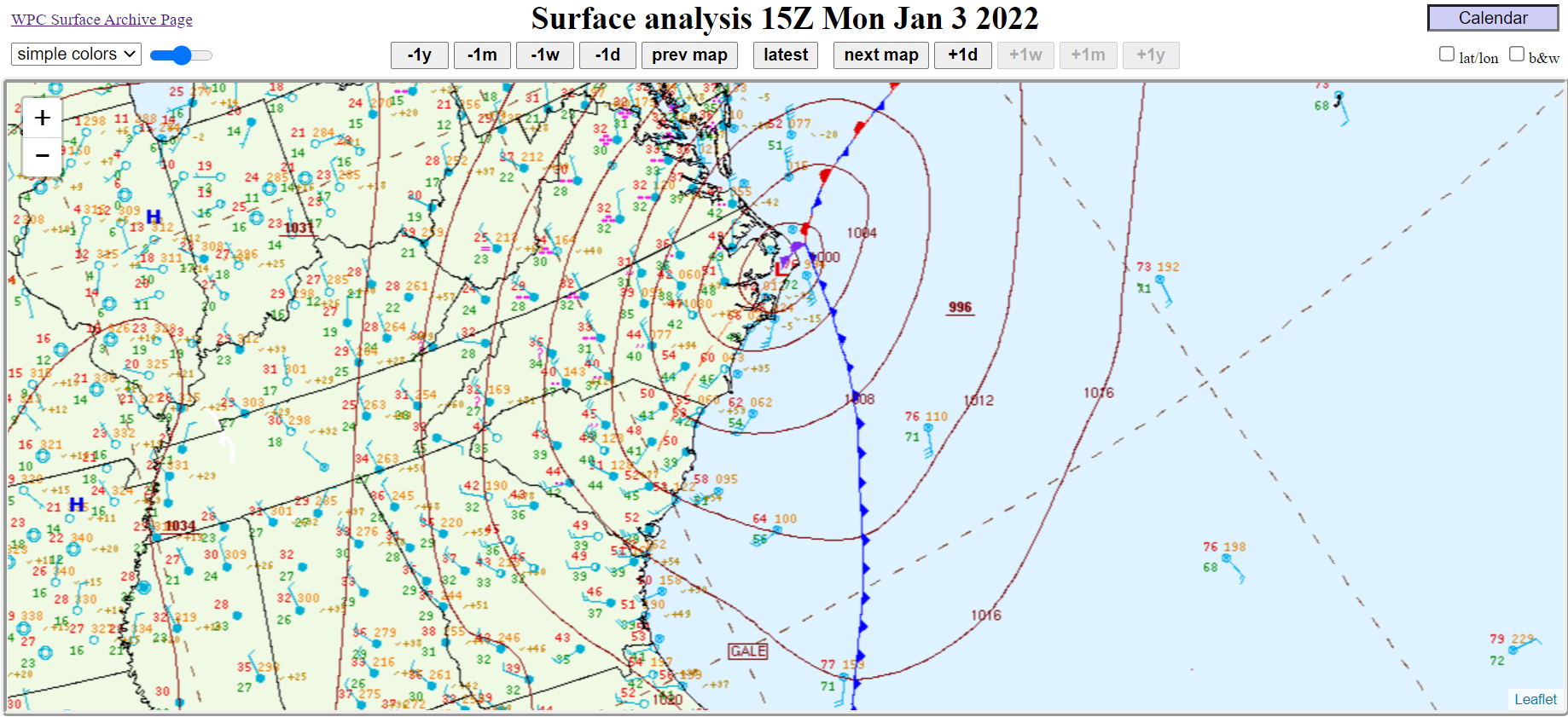
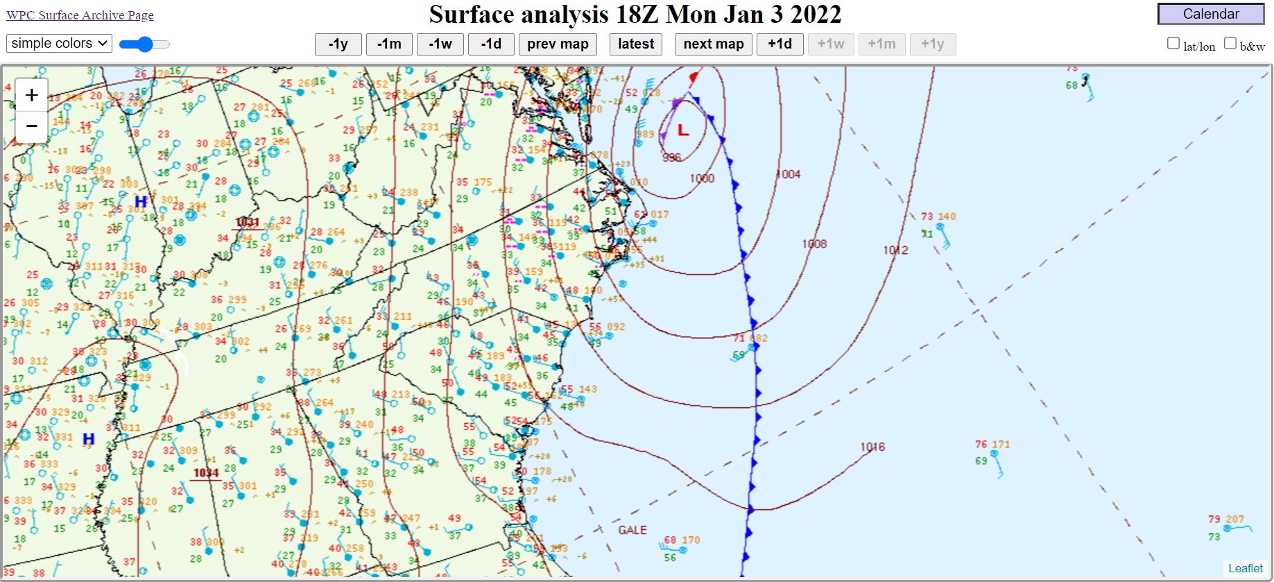
The area of low pressure continued to strengthen as it moved over the eastern Pamlico Sound and directly over Hatteras Island at around 1000 MB mid morning into the afternoon. The strength and track of the low was the perfect recipe for soundside flooding in Hatteras Village as strong south to southwest winds quickly shifted west and eventually northwest with the passage of the low. Significant flooding was reported in Hatteras Village with portions of NC 12 closed. As the storm moved off the coast a peak wind gust to 86 MPH was measured (hurricane force) at Oregon Inlet! Through multiple high tide cycles Monday January 3rd into Tuesday January 4th, the combination of high water, breached dunes, wave run up, and large waves caused high water on NC 12 north of Rodanthe, along with flooding on the south end of Ocracoke Island. These same areas were hard hit with similar water levels just this past November 2021.
As the storm system moved away from our coast, much colder air moved in across Eastern North Carolina. We had just enough leftover moisture around for flurries to be reported farther inland in places such as Greenville.
The loop below is of surface analysis from Sunday evening, January 2nd at 7 PM through midday Monday January 3rd at 1 PM. You can see the area of low pressure across the Upstate of South Carolina early on the morning of the 3rd, moving across Eastern North Carolina later in the morning. The low really strengthens while it moves over the Pamlico Sound and off the Outer Banks by late morning to early afternoon. You can play the loop by clicking start. If you would like to increase or decrease the speed of the loop, use the slider bar. You can also advance the loop image by image but clicking one of the arrows.
.PNG)
Scroll through the event using these tabs to learn more.
Coastal Flooding/Severe
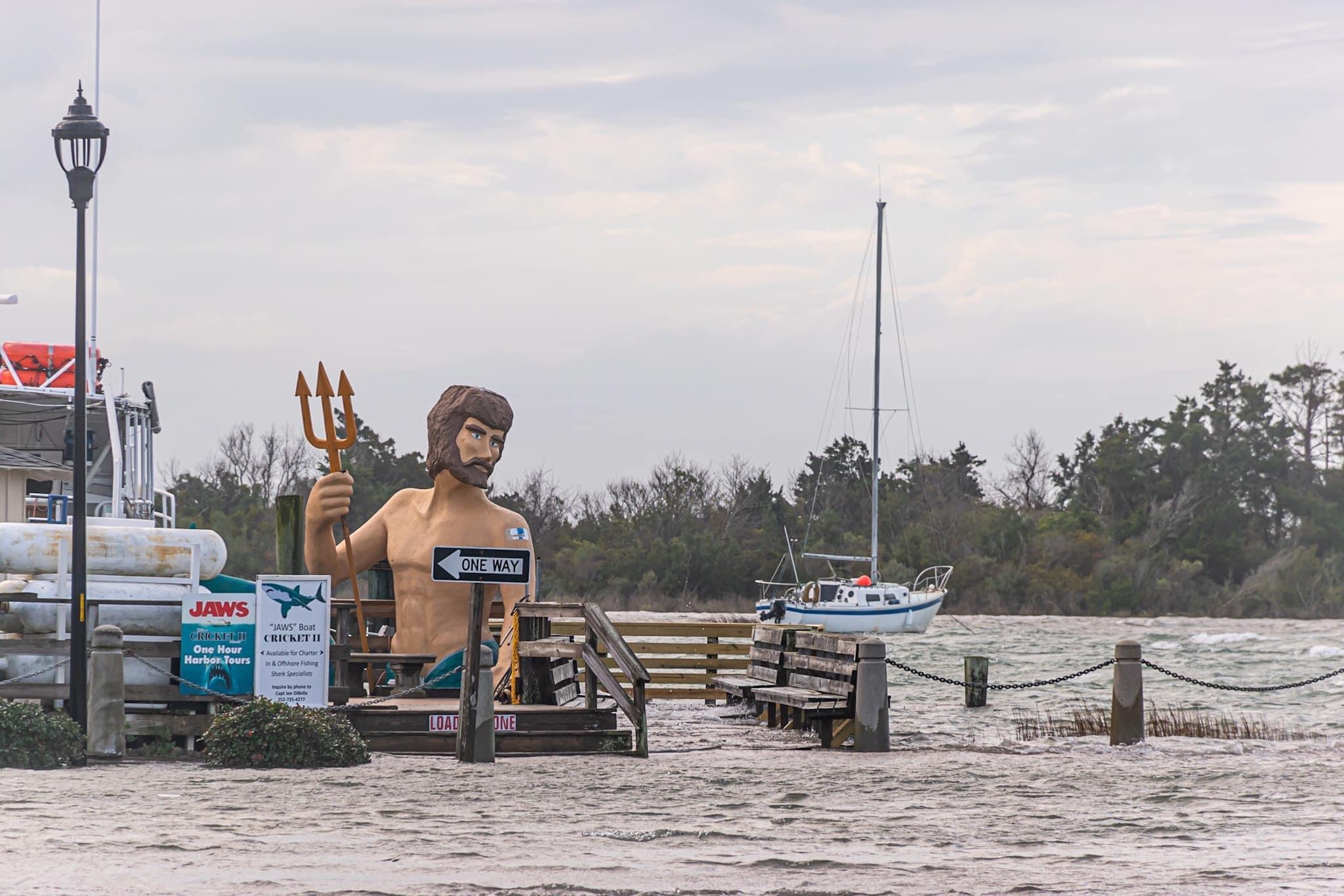
Coastal flooding can be a frequent occurrence along the coast of North Carolina. January 2022 provided an excellent example of how other factors can combine with a storm, to produce major impacts. The flooding was caused by three different factors: 1) Certain periods of the year we have higher than normal astronomical tides. These higher tides can cause flooding even absent of other weather factors and often are referred to as "sunny day" flooding or the "king tides". These higher tides caused elevated water levels Sunday January 2nd through Tuesday January 4th. 2) During the same time period, strong south to southwest winds ahead of a strong storm system helped caused these already high water levels to be even higher. This was especially true across portions of Carteret County such as Beaufort and Morehead City, where southerly winds can help pile water up against the coast. 3) Lastly, during this same period an area of low pressure moved right across Pamlico Sound and Hatteras Island. The track and strength of the low were key in shifting south winds into the west quickly, which sloshed water back toward Hatteras Island causing quick water level rises in Hatteras Village. As the low departed, tide levels remains elevated as powerful northeasterly swell built, causing oceanside overwash issues along NC 12 north of Rodanthe, in Avon, on the north side of Buxton, and on Ocracoke Island.
Below are some weather related graphs and information. Please see the videos and pictures tab for more on the impacts.
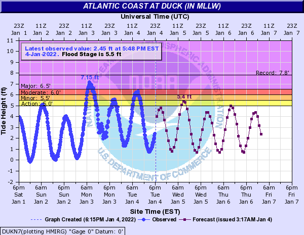
The above gauge at Duck shows that major flood stage (6.5 feet MLLW) was exceeded at high tide on Monday morning January 3rd. High water levels continued at the next two high tide cycles and when combined with breaking waves and wave run up on the beaches, breached dunes along Highway 12 north of Rodanthe and on Ocracoke Island, causing multiple sections of Highway 12 to be closed into Tuesday January 4th. The peak value of 7.15 feet (MLLW) was the 3rd all time highest value at Duck and the 2nd highest value in a non tropical event.
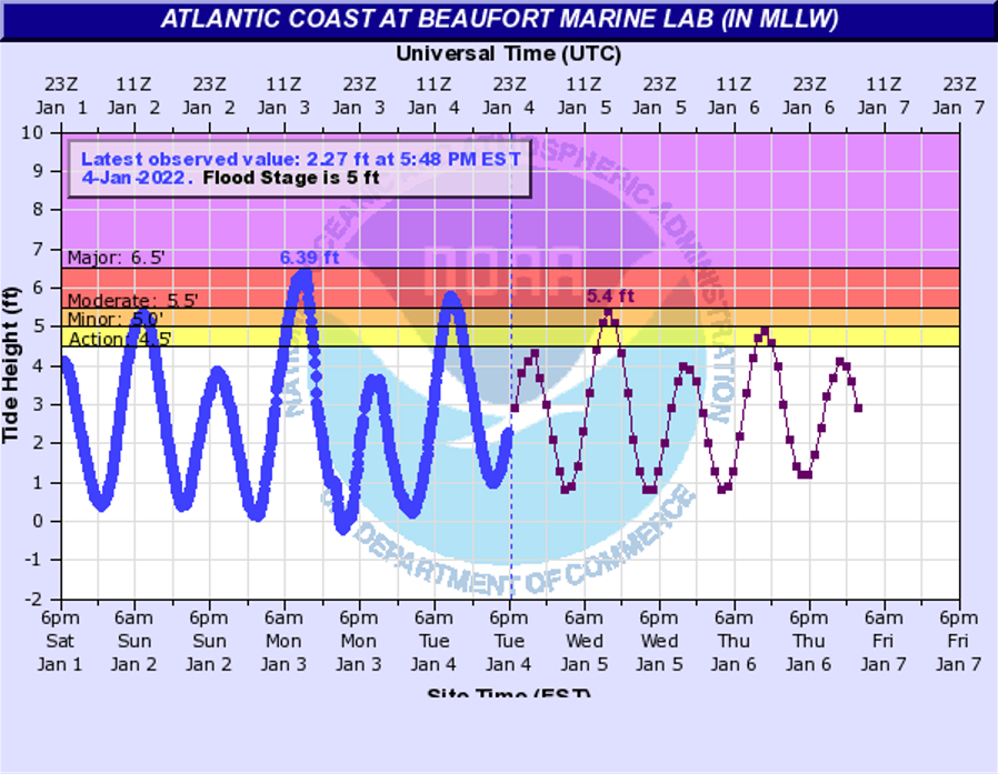
The above gauge at Beaufort shows that minor to moderate coastal flooding occurred multiple high tide cycles starting on January 2nd and lasting through January 4th. Water was observed during these high tides in Downtown Morehead City along Sheperd Street between 9th and 12th streets and along the Morehead City Waterfront. Downtown Beaufort also had flooding along Front Street along the waterfront.
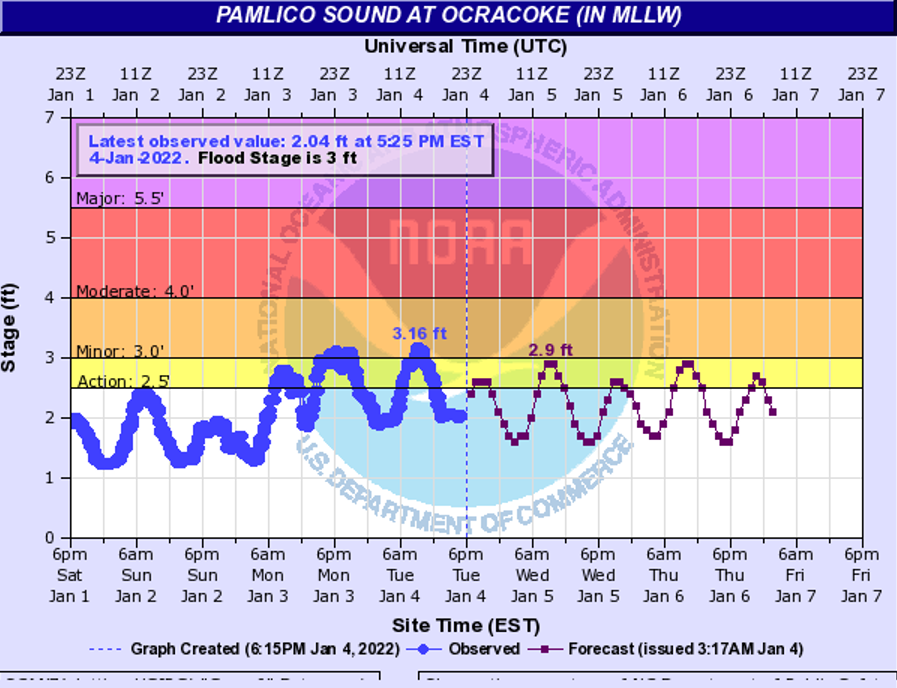
Flooding also occurred at the eastern end of the Pamlico Sound as strong south to southwest winds ahead of the strong system pushed the water away from Hatteras Island. On Monday morning as the strong low move over the Pamlico Sound, winds quickly shifted into the west and eventually northwest, causing sharp water level rises in Hatteras Village. Portions of NC 12 were closed on Hatteras Island with significant flooding in the village on Monday January 3rd. On Ocracoke Island, NC 12 was closed between the Ferry Terminal and National Park Services Pony Pen area into Tuesday January 4th with combined impacts from Ocean overwash as well.

Much of Eastern North Carolina experienced very warm weather early Monday, just ahead of the storm system, bringing the potential for severe thunderstorms and tornadoes. A line of thunderstorms helped to mix down strong winds, causing areas of wind damage across Eastern North Carolina. Much of the area was under a Tornado WATCH at the time.
000
NWUS52 KMHX 032108
LSRMHX

PRELIMINARY LOCAL STORM REPORT...SUMMARY
NATIONAL WEATHER SERVICE NEWPORT/MOREHEAD CITY NC
408 PM EST MON JAN 3 2022

..TIME...   ...EVENT...      ...CITY LOCATION...     ...LAT.LON...
..DATE...   ....MAG....      ..COUNTY LOCATION..ST.. ...SOURCE....
            ..REMARKS..


0735 AM     TSTM WND DMG     9 W TEACHEY             34.75N 78.16W
01/03/2022                   DUPLIN             NC   UTILITY COMPANY

            FOUR COUNTY ELECTRIC COOPERATIVE REPORTED
            TREE LIMBS ON POWERLINES NORTHEAST OF
            HARRELLS ALONG BULL TAIL RD.


0751 AM     TSTM WND DMG     2 NE WALLACE            34.78N 77.93W
01/03/2022                   DUPLIN             NC   UTILITY COMPANY

            FOUR COUNTY ELECTRIC COOPERATIVE REPORTED
            TREES LIMBS ON POWERLINES ALONG RIVENBARK
            TOWN RD. IN WALLACE.


0810 AM     NON-TSTM WND GST 1 NNW BEULAVILLE        34.94N 77.78W
01/03/2022  E46 MPH          DUPLIN             NC   TRAINED SPOTTER

            SKY WARN SPOTTER REPORTED A NON-TSTM WIND
            GUST OF 46 MPH.

0810 AM     NON-TSTM WND GST 1 NNW BEULAVILLE        34.94N 77.78W
01/03/2022  E46 MPH          DUPLIN             NC   TRAINED SPOTTER

            SKY WARN SPOTTER REPORTED A NON-TSTM WIND
            GUST OF 46 MPH.

0837 AM     TSTM WND DMG     2 SSE HAVELOCK          34.88N 76.89W
01/03/2022                   CRAVEN             NC   PUBLIC

            POWER LINE DOWN ON THE CORNER OF MCCOTTER
            BLVD AND JARRETT LN.

0837 AM     TSTM WND DMG     2 SSE HAVELOCK          34.88N 76.89W
01/03/2022                   CRAVEN             NC   PUBLIC

            POWER LINE DOWN ON THE CORNER OF MCCOTTER
            BLVD AND JARRETT LN.

0905 AM     TSTM WND DMG     PAMLICO BEACH           35.40N 76.61W
01/03/2022                   BEAUFORT           NC   UTILITY COMPANY

            TIDELAND ELECTRIC COOPERATIVE REPORTED A
            BROKEN POWER POLE AT PAMLICO BEACH. TIME
            BASED ON RADAR.

0905 AM     TSTM WND DMG     PAMLICO BEACH           35.40N 76.61W
01/03/2022                   BEAUFORT           NC   UTILITY COMPANY

            TIDELAND ELECTRIC COOPERATIVE REPORTED A
            BROKEN POWER POLE AT PAMLICO BEACH. TIME
            BASED ON RADAR.

0914 AM     NON-TSTM WND DMG 2 SE CATHERINE LAKE     34.77N 77.54W
01/03/2022                   ONSLOW             NC   911 CALL CENTER

            TREE AND POWER LINE REPORTED DOWN BY THE
            ONSLOW COUNTY 911 CENTER.

0914 AM     NON-TSTM WND DMG 2 SE CATHERINE LAKE     34.77N 77.54W
01/03/2022                   ONSLOW             NC   911 CALL CENTER

            TREE AND POWER LINE REPORTED DOWN BY THE
            ONSLOW COUNTY 911 CENTER.

0936 AM     COASTAL FLOOD    1 ESE MOREHEAD CITY     34.72N 76.71W
01/03/2022                   CARTERET           NC   FIRE DEPT/RESCUE

            COASTAL FLOODING REPORTED BY THE FIRE/EMS IN
            MOREHEAD CITY ON THE CORNER OF SHEPARD ST.
            AND 9TH ST.

0936 AM     COASTAL FLOOD    1 ESE MOREHEAD CITY     34.72N 76.71W
01/03/2022                   CARTERET           NC   FIRE DEPT/RESCUE

            COASTAL FLOODING REPORTED BY THE FIRE/EMS IN
            MOREHEAD CITY ON THE CORNER OF SHEPARD ST.
            AND 9TH ST.

0950 AM     NON-TSTM WND DMG HARKERS ISLAND          34.70N 76.56W
01/03/2022                   CARTERET           NC   UTILITY COMPANY

            CARTERET-CRAVEN ELECTRIC COOPERATIVE
            REPORTED A SNAPPED POWER POLE ON HARKERS
            ISLAND.

0950 AM     NON-TSTM WND DMG HARKERS ISLAND          34.70N 76.56W
01/03/2022                   CARTERET           NC   UTILITY COMPANY

            CARTERET-CRAVEN ELECTRIC COOPERATIVE
            REPORTED A SNAPPED POWER POLE ON HARKERS
            ISLAND.

1019 AM     TSTM WND GST     1 NNE AVON              35.37N 75.50W
01/03/2022  M61 MPH          DARE               NC   MESONET

            WXFLOW SITE ON THE NORTH SIDE OF AVON
            REPORTED A 53 KNOT (61 MPH) THUNDERSTORM
            WIND GUST.

1019 AM     TSTM WND GST     1 NNE AVON              35.37N 75.50W
01/03/2022  M61 MPH          DARE               NC   MESONET

            WXFLOW SITE ON THE NORTH SIDE OF AVON
            REPORTED A 53 KNOT (61 MPH) THUNDERSTORM
            WIND GUST.

1025 AM     TSTM WND GST     1 NNW RODANTHE          35.61N 75.47W
01/03/2022  M59 MPH          DARE               NC   PUBLIC

            PUBLIC WEATHER STATION OBSERVED A 51 KNOT
            (59 MPH) THUNDERSTORM WIND GUST.

1100 AM     NON-TSTM WND DMG 1 SSE HOOKERTON         35.41N 77.58W
01/03/2022                   GREENE             NC   911 CALL CENTER

            GREENE COUNTY 911 REPORTED A TREE DOWN ALONG
            HUGO RD.

1113 AM     COASTAL FLOOD    2 N COLUMBIA            35.95N 76.25W
01/03/2022                   TYRRELL            NC   TRAINED SPOTTER

            SOUND FLOODING ON SOUTHERN COAST OF
            ALBEMARLE SOUND. 12+ INCHES OF SOUND
            FLOODING INUNDATION IN PLACES.
            DOCKS/BULKHEADS LOSING MATERIALS.

0337 PM     COASTAL FLOOD    HATTERAS VILLAGE        35.22N 75.69W
01/03/2022                   DARE               NC   PUBLIC

            MULTIPLE IMAGES AND VIDEOS ON TWITTER OF
            WATER RISES IN HATTERAS VILLAGE, COVERING
            PORTIONS OF NC-12 AND REACHING HOMES.


0545 PM     COASTAL FLOOD    HATTERAS VILLAGE        35.22N 75.69W
01/03/2022                   DARE               NC   PUBLIC

            CALLER REPORTED NEIGHBOR WALKED THROUGH
            WAIST-HIGH WATER AFTER MOVING THEIR CAR.
            ESTIMATED 1-2 FEET ON THE ROAD, 2-3 FEET IN
            LOW-LYING AREAS.


&&

$$
&&
|
Wind Reports
Tropical storm force gusts (39 MPH or higher) were common across the entire area with hurricane force gusts across the Outer Banks. The peak wind in the area was 86 MPH at Oregon Inlet.
PUBLIC INFORMATION STATEMENT NATIONAL WEATHER SERVICE NEWPORT/MOREHEAD CITY NC 413 PM EST MON JAN 3 2022 ...HIGHEST WIND REPORTS IN THE PAST 24 HOURS... LOCATION SPEED TIME/DATE PROVIDER ...NORTH CAROLINA... ...BEAUFORT COUNTY... WASHINGTON (OCW AWOS) 32 MPH 1215 PM 01/03 AWOS BUNYAN RAWS 31 MPH 1213 PM 01/03 RAWS ...CARTERET COUNTY... INDIAN BEACH 0.3 WSW 58 MPH 0846 AM 01/03 CWOP FORT MACON (WXFLOW) 58 MPH 0905 AM 01/03 WXFLOW ATLANTIC BEACH 0.4 E 52 MPH 0901 AM 01/03 CWOP BEAUFORT (MRH ASOS) 52 MPH 0902 AM 01/03 ASOS PINEY ISLAND (NBT AWOS) 51 MPH 1022 AM 01/03 AWOS BEAUFORT 49 MPH 1054 AM 01/03 CWOP NEWPORT 7.5 E 44 MPH 0859 AM 01/03 CWOP CAPE LOOKOUT 44 MPH 0300 PM 01/03 NDBC BEAUFORT (DUKE MARINE LAB) 43 MPH 0842 AM 01/03 NOS-NWLON EMERALD ISLE 3 WSW 41 MPH 0215 PM 01/03 CWOP BOGUE FIELD (NJM ASOS) 39 MPH 0930 AM 01/03 AWOS MOREHEAD CITY 4.7 W 38 MPH 0900 AM 01/03 CWOP NEWPORT 6.4 SW 37 MPH 1001 AM 01/03 CWOP CAPE CARTERET 0.6 E 35 MPH 1015 AM 01/03 CWOP CROATAN RAWS 34 MPH 0205 PM 01/03 RAWS CEDAR ISLAND RAWS 30 MPH 1125 AM 01/03 RAWS ...CRAVEN COUNTY... CHERRY POINT (NKT ASOS) 48 MPH 0326 PM 01/03 AWOS NEW BERN (EWN ASOS) 47 MPH 0823 AM 01/03 ASOS HAVELOCK 0.7 NW 39 MPH 1016 AM 01/03 CWOP ...DARE COUNTY... OREGON INLET CG (WXFLOW) 86 MPH 0148 PM 01/03 WXFLOW AVON (WXFLOW) 66 MPH 1012 AM 01/03 WXFLOW KHK RESORT (WXFLOW) 63 MPH 0244 PM 01/03 WXFLOW RODANTHE 0.6 N 57 MPH 0220 PM 01/03 CWOP FRISCO (HSE ASOS) 56 MPH 1003 AM 01/03 ASOS OREGON INLET MARINA 56 MPH 1012 AM 01/03 NOS-NWLON REAL SLICK (WXFLOW) 56 MPH 0351 PM 01/03 WXFLOW OREGON INLET (WXFLOW) 55 MPH 0206 PM 01/03 WXFLOW NAGS HEAD 55 MPH 0227 PM 01/03 CWOP BUXTON (WXFLOW) 55 MPH 0328 PM 01/03 WXFLOW HATTERAS HIGH (WXFLOW) 54 MPH 0337 PM 01/03 WXFLOW BUXTON 48 MPH 0330 PM 01/03 RAWS BUXTON 0.7 SE 47 MPH 1017 AM 01/03 CWOP FRISCO 0.3 SW 47 MPH 0332 PM 01/03 CWOP SOUTHERN SHORES 1.7 NNW 46 MPH 0148 PM 01/03 CWOP DARE CO GNRY RAN (2DP AWOS) 41 MPH 0119 PM 01/03 AWOS DARE BOMB RANGE RAWS 39 MPH 0328 PM 01/03 RAWS MANTEO (MQI AWOS) 31 MPH 0615 AM 01/03 AWOS ...DUPLIN COUNTY... WALLACE 6.4 WNW (WILLIAMSDAL 35 MPH 0745 AM 01/03 NC-ECONET ...HYDE COUNTY... ENGELHARD (7W6 AWOS) 43 MPH 0135 PM 01/03 AWOS ...LENOIR COUNTY... KINSTON 2.5 NNE (CUNNINGHAM 36 MPH 0835 AM 01/03 NC-ECONET KINSTON (ISO AWOS) 35 MPH 0856 AM 01/03 AWOS ...ONSLOW COUNTY... SNEADS FERRY 1.7 SE 46 MPH 0145 PM 01/03 CWOP JACKSONVILLE 1.7 NNW 45 MPH 0858 AM 01/03 CWOP JACKSONVILLE (NCA ASOS) 44 MPH 0151 PM 01/03 AWOS RICHLANDS (OAJ AWOS) 40 MPH 0856 AM 01/03 AWOS ...PITT COUNTY... GREENVILLE (PGV AWOS) 30 MPH 0815 AM 01/03 AWOS GREENVILLE (DOWDY FICKLEN ST 30 MPH 0820 AM 01/03 MESOWEST ...WASHINGTON COUNTY... ROPER 9.8 ENE 38 MPH 0830 AM 01/03 CWOP TIDEWATER RESEARCH STATION 38 MPH 0135 PM 01/03 NC-ECONET CRESWELL 2.6 SSW 32 MPH 1130 AM 01/03 CWOP ...MARITIME STATIONS... JENNETTES PIER (WXFLOW) 81 MPH 0234 PM 01/03 WXFLOW ALLIGATOR RIVER BR (WXFLOW) 72 MPH 0933 AM 01/03 WXFLOW ROANOKE SOUND CHANNEL (WXFLO 70 MPH 0951 AM 01/03 WXFLOW CROATAN SOUND 65 MPH 0120 PM 01/03 WXFLOW AVON SOUND (WXFLOW) 63 MPH 0359 PM 01/03 WXFLOW DUCK PIER 63 MPH 0142 PM 01/03 NOS-NWLON DIAMOND BUOY (41025) 58 MPH 1020 AM 01/03 NDBC OCRACOKE (WXFLOW) 57 MPH 0952 AM 01/03 WXFLOW PAMLICO SOUND (WXFLOW) 53 MPH 0231 PM 01/03 WXFLOW NORTH RIVER 50 MPH 1028 AM 01/03 WXFLOW && && && |
Videos
Gusty winds occurred over much of Eastern North Carolina, especially ahead of the area of low pressure as it moved through the area. Some of these winds were enhanced as heavier rain and even thunderstorms moved through. This video is from Monday morning January 3rd as heavy rain and wind move through the NWS office in Newport, NC.
Pictures
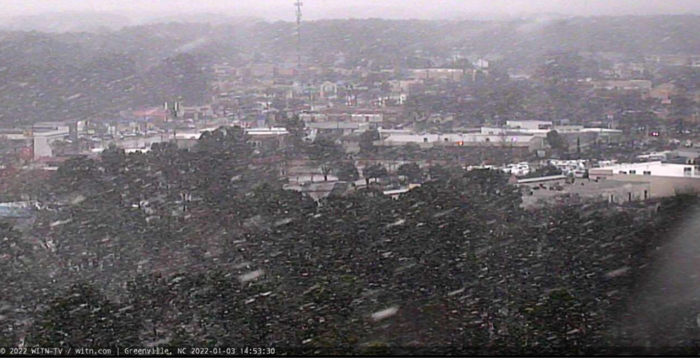
Greenville, NC just before 3 PM on Monday January 3rd
Credit ECU Pirate Cam
January 3rd Carteret County
|
Morehead City Waterfront
|
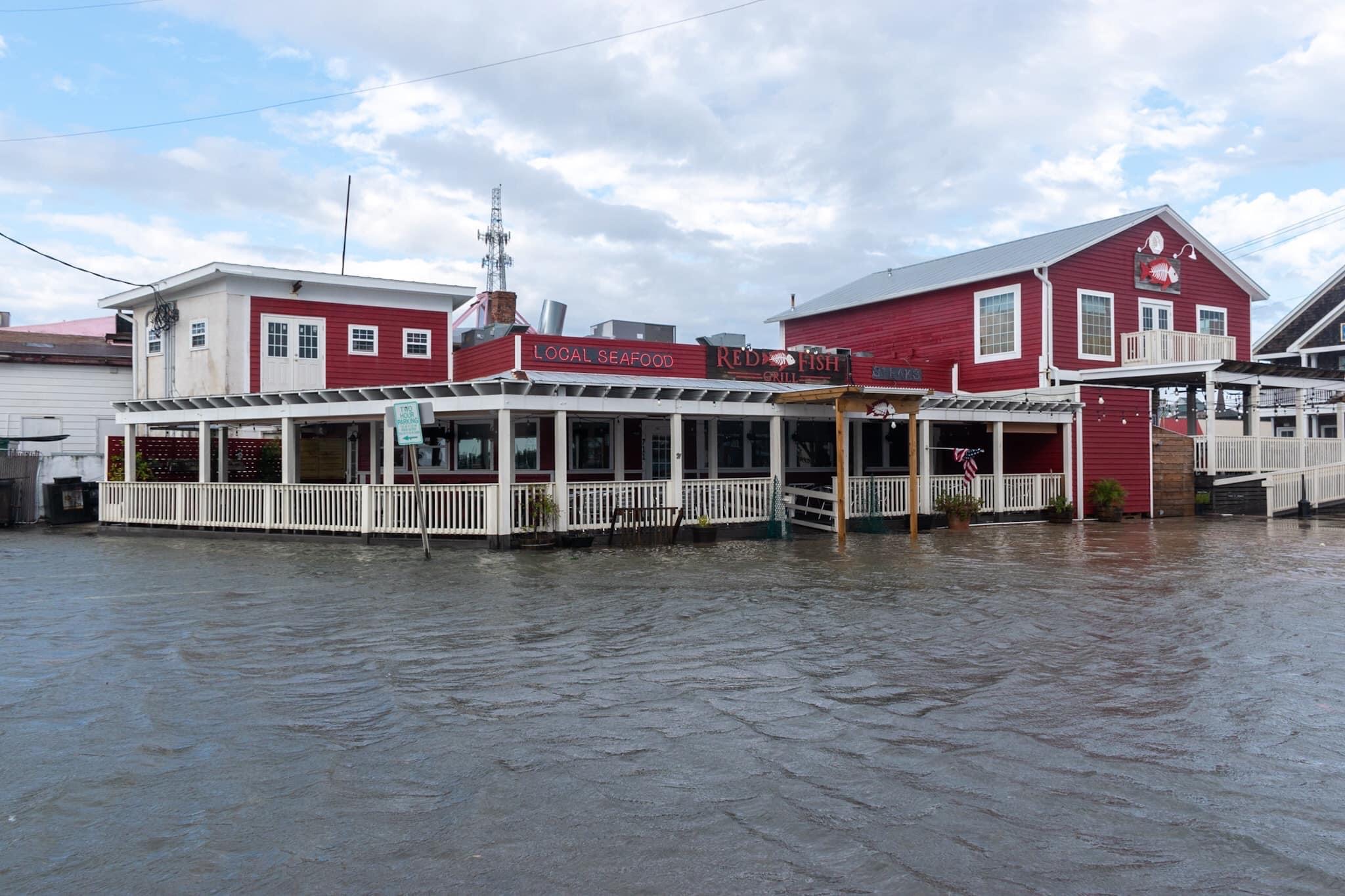
Red Fish Grill. Downtown Morehead City.
|
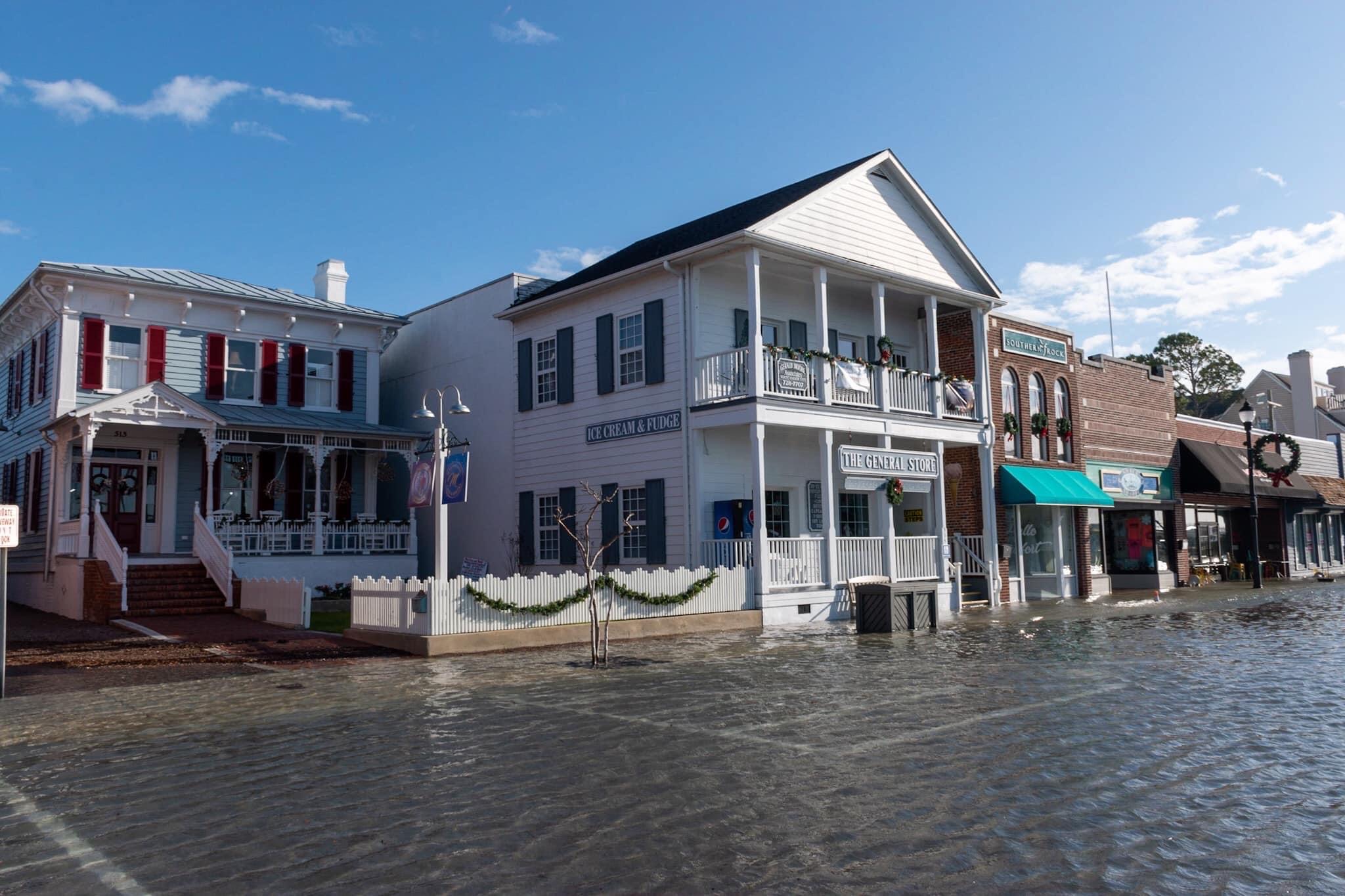
General Store. Front Street. Beaufort.
|
Marine
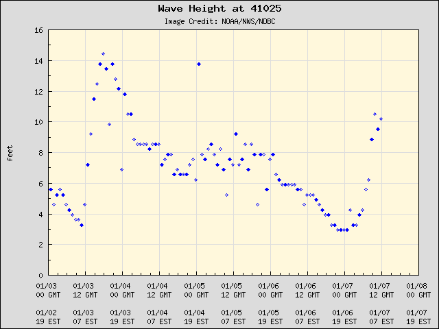
The Diamond Shoals buoy is located less than 20 miles off from Cape Point on Hatteras Island. Waves peaked at around 16 feet on the evening of the 6th (Friday night).
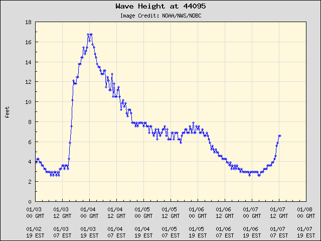
The Onslow Bay buoy is located well off the Crystal Coast. Waves peaked at around 16 feet on the evening of the 6th (Friday night) into early Saturday morning (7th).
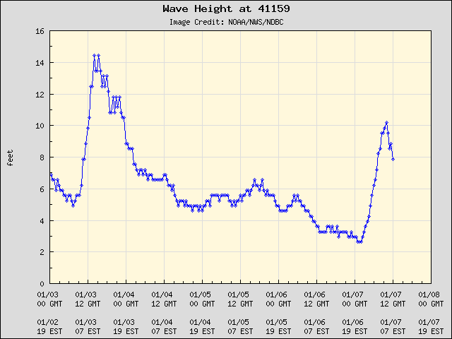
The buoy above is located off Oregon Inlet. Waves peaked at around 17 feet on the evening of the 7th (Sunday night) into early morning Monday morning (8th).
Impacts
***Check back for more soon***


.png) Surf Forecast/Rip Currents
Surf Forecast/Rip Currents Tropical Weather
 Map View
 Weather Hazard Briefing (when applicable)
 Forecaster Discussion
 Marine
 Text Products
.png) Skywarn
Skywarn Submit Storm Reports