NWS Newport/Morehead City, NC is responsible for marine forecasts for the coastal waters from Duck, NC to North Topsail, NC out to 20 nautical miles, as well as the tidal inshore waters from the Albemarle Sound to New River. Forecasts are updated frequently based on the latest observations and forecast guidance.
To report unusual marine conditions, including waterspout, to the National Weather Service call toll free 800-889-6889.
Select Point Forecasts:
| 145 | 230 | 255 | 275 | 285 | 296 | 315 | 342 | 345 | 355 |
| Wimble Shoals | Diamond Shoals | Lookout Shoals | Eastern Albemarle Sound (ICW) | Mouth of Pungo River (ICW) | Mouth of Neuse River (ICW) |
Other Forecast Resources:
814
WHUS72 KMHX 051222
MWWMHX
URGENT - MARINE WEATHER MESSAGE
National Weather Service Newport/Morehead City NC
822 AM EDT Mon May 5 2025
AMZ135-231-051800-
/O.NEW.KMHX.SC.Y.0044.250505T1222Z-250505T1800Z/
Pamlico Sound-Croatan and Roanoke Sounds-
822 AM EDT Mon May 5 2025
...SMALL CRAFT ADVISORY IN EFFECT UNTIL 2 PM EDT THIS AFTERNOON...
* WHAT...Southeast winds 20 to 25 kt and choppy waters.
* WHERE...Pamlico Sound and Croatan and Roanoke Sounds.
* WHEN...Until 2 PM EDT this afternoon.
* IMPACTS...Conditions will be hazardous to small craft.
PRECAUTIONARY/PREPAREDNESS ACTIONS...
Inexperienced mariners, especially those operating smaller
vessels, should avoid navigating in hazardous conditions.
&&
$$
AMZ150-152-051800-
/O.NEW.KMHX.SC.Y.0044.250505T1222Z-250505T1800Z/
S of Currituck Beach Light to Oregon Inlet NC out 20 nm-
S of Oregon Inlet to Cape Hatteras NC out 20 nm-
822 AM EDT Mon May 5 2025
...SMALL CRAFT ADVISORY IN EFFECT UNTIL 2 PM EDT THIS AFTERNOON...
* WHAT...Southeast winds 15 to 25 kt with gusts up to 30 kt and
seas 5 to 8 ft.
* WHERE...The coastal waters from Duck to Cape Hatteras.
* WHEN...Until 2 PM EDT this afternoon.
* IMPACTS...Conditions will be hazardous to small craft.
PRECAUTIONARY/PREPAREDNESS ACTIONS...
Inexperienced mariners, especially those operating smaller
vessels, should avoid navigating in hazardous conditions.
&&
$$
688
FZUS52 KMHX 110733
CWFMHX
Coastal Waters Forecast for North Carolina
National Weather Service Newport/Morehead City NC
333 AM EDT Sun May 11 2025
From S of Currituck Beach Light to N of Surf City NC out 20 NM,
including the Albemarle and Pamlico Sounds and the Monitor
National Marine Sanctuary
AMZ100-112045-
333 AM EDT Sun May 11 2025
.Synopsis for Eastern North Carolina coastal waters...
A slow moving low pressure system over the Deep South will
advance towards the Carolinas and bring an extended period of
unsettled weather to the area beginning this morning. This system
will eventually weaken and dissipate by mid week, with a ridge of
high pressure building in behind it by late next week.
$$
AMZ230-112045-
Albemarle Sound-
333 AM EDT Sun May 11 2025
.TODAY...SW winds around 5 kt, becoming SE late this morning,
then becoming E this afternoon. Waves 1 ft or less. A slight
chance of showers this afternoon.
.TONIGHT...SE winds 5 to 10 kt. Waves 1 ft or less.
.MON...SE winds 10 to 15 kt. Waves 1 to 2 ft. A chance of
showers.
.MON NIGHT...SE winds 10 to 15 kt. Waves around 2 ft. A slight
chance of tstms. A chance of showers in the evening, then showers
likely after midnight.
.TUE...SE winds 15 to 20 kt. Gusts up to 25 kt in the afternoon.
Waves around 2 ft. Showers with a chance of tstms.
.TUE NIGHT...SE winds 15 to 20 kt, becoming S 10 to 15 kt after
midnight. Waves around 2 ft. A chance of tstms. Showers, mainly
in the evening.
.WED...S winds 5 to 10 kt. Waves 1 ft or less. A chance of
showers in the morning, then showers likely with a chance of
tstms in the afternoon.
.WED NIGHT...SW winds 5 to 10 kt. Waves 1 ft or less. Showers
likely with a chance of tstms in the evening, then a chance of
showers after midnight.
.THU...SW winds 5 to 10 kt, becoming S in the afternoon. Waves
1 ft or less. A chance of showers and tstms in the afternoon.
.THU NIGHT...SW winds around 5 kt. Waves 1 ft or less. A chance
of showers and tstms in the evening.
Winds and waves higher in and near tstms.
$$
AMZ131-112045-
Alligator River-
333 AM EDT Sun May 11 2025
.TODAY...S winds around 5 kt, becoming E late this morning and
afternoon. Waves flat. A slight chance of showers this afternoon.
.TONIGHT...SE winds 5 to 10 kt. Waves light chop. A slight chance
of showers.
.MON...SE winds 5 to 10 kt. Waves light chop. A chance of
showers. A slight chance of tstms in the afternoon.
.MON NIGHT...SE winds 10 to 15 kt. Waves a moderate chop. A
slight chance of tstms. A chance of showers in the evening, then
showers likely after midnight.
.TUE...SE winds 10 to 15 kt. Gusts up to 25 kt in the afternoon.
Waves a moderate chop. Showers with a chance of tstms.
.TUE NIGHT...SE winds 10 to 15 kt, becoming S 5 to 10 kt after
midnight. Waves a moderate chop, diminishing to light chop after
midnight. A chance of tstms. Showers.
.WED...S winds 5 to 10 kt. Waves light chop. A chance of showers
in the morning, then showers likely with a chance of tstms in the
afternoon.
.WED NIGHT...SW winds 5 to 10 kt. Waves light chop. Showers
likely with a chance of tstms in the evening, then a chance of
showers after midnight.
.THU...SW winds around 5 kt. Waves flat. A chance of showers. A
chance of tstms in the afternoon.
.THU NIGHT...SW winds around 5 kt. Waves flat. A chance of
showers and tstms in the evening.
Winds and waves higher in and near tstms.
$$
AMZ231-112045-
Croatan and Roanoke Sounds-
333 AM EDT Sun May 11 2025
.TODAY...S winds around 5 kt, becoming E late this morning and
early afternoon, then becoming SE late. Waves flat, increasing to
light chop late. A slight chance of showers this afternoon.
.TONIGHT...SE winds 5 to 10 kt. Waves light chop.
.MON...SE winds 10 to 15 kt. Waves a moderate chop. A chance of
showers.
.MON NIGHT...SE winds 10 to 15 kt, increasing to 15 to 20 kt
after midnight. Waves a moderate chop, increasing to choppy after
midnight. A slight chance of tstms. A chance of showers in the
evening, then showers likely after midnight.
.TUE...SE winds 15 to 25 kt. Waves choppy. Showers with a chance
of tstms.
.TUE NIGHT...S winds 15 to 25 kt, diminishing to 10 to 15 kt
after midnight. Waves choppy, diminishing to a moderate chop after
midnight. Showers with a chance of tstms.
.WED...S winds around 10 kt. Waves light chop. Showers likely
with a chance of tstms.
.WED NIGHT...SW winds 5 to 10 kt. Waves light chop. Showers
likely with a chance of tstms in the evening, then a chance of
showers after midnight.
.THU...SW winds 5 to 10 kt. Waves light chop. A chance of
showers. A chance of tstms in the afternoon.
.THU NIGHT...SW winds 5 to 10 kt. Waves light chop. A chance of
showers and tstms in the evening.
Winds and waves higher in and near tstms.
$$
AMZ135-112045-
Pamlico Sound-
333 AM EDT Sun May 11 2025
.TODAY...SE winds 5 to 10 kt. Waves 1 ft or less. A slight chance
of showers late this morning. A chance of showers this afternoon.
.TONIGHT...SE winds 5 to 10 kt, increasing to 10 to 15 kt after
midnight. Waves 1 ft or less. A chance of showers, mainly in the
evening.
.MON...SE winds around 15 kt. Waves around 2 ft. A chance of
showers with a slight chance of tstms.
.MON NIGHT...SE winds 15 to 25 kt. Waves 2 to 3 ft. A slight
chance of tstms. A chance of showers in the evening, then showers
likely after midnight.
.TUE...SE winds around 20 kt with gusts up to 25 kt. Waves 2 to
3 ft. Showers with a chance of tstms.
.TUE NIGHT...S winds 15 to 25 kt, diminishing to 10 to 15 kt
after midnight. Waves 2 to 3 ft. Showers with a chance of tstms.
.WED...S winds around 10 kt. Waves 1 ft or less. Showers likely
with a chance of tstms.
.WED NIGHT...SW winds around 10 kt. Waves 1 ft or less. A chance
of tstms in the evening. A chance of showers.
.THU...SW winds 5 to 10 kt. Waves 1 ft or less. A chance of
showers. A chance of tstms in the afternoon.
.THU NIGHT...SW winds around 10 kt. Waves 1 ft or less. A chance
of showers and tstms in the evening.
Winds and waves higher in and near tstms.
$$
AMZ136-112045-
Pamlico and Pungo Rivers-
333 AM EDT Sun May 11 2025
.TODAY...E winds around 5 kt, becoming SE late this morning and
afternoon. Waves flat, increasing to light chop late this morning
and afternoon. A slight chance of showers early this morning,
then a chance of showers late this morning and afternoon.
.TONIGHT...SE winds 5 to 10 kt, increasing to 10 to 15 kt after
midnight. Waves light chop, increasing to a moderate chop after
midnight. A chance of showers. A slight chance of tstms after
midnight.
.MON...SE winds 10 to 15 kt. Waves a moderate chop. Showers
likely with a slight chance of tstms.
.MON NIGHT...SE winds 10 to 15 kt. Waves a moderate chop. A
slight chance of tstms. Showers.
.TUE...SE winds 10 to 15 kt. Waves a moderate chop. Showers with
a chance of tstms.
.TUE NIGHT...S winds 10 to 15 kt, diminishing to 5 to 10 kt after
midnight. Waves a moderate chop, diminishing to light chop after
midnight. A chance of tstms. Showers.
.WED...S winds 5 to 10 kt. Waves light chop. A chance of showers
in the morning, then showers likely with a chance of tstms in the
afternoon.
.WED NIGHT...SW winds 5 to 10 kt. Waves light chop. Showers
likely with a chance of tstms in the evening, then a chance of
showers after midnight.
.THU...SW winds around 5 kt. Waves flat. A chance of showers. A
chance of tstms in the afternoon.
.THU NIGHT...SW winds around 5 kt. Waves flat. A chance of
showers and tstms in the evening.
Winds and waves higher in and near tstms.
$$
AMZ137-112045-
Neuse and Bay Rivers-
333 AM EDT Sun May 11 2025
.TODAY...E winds 5 to 10 kt. Waves light chop. A chance of
showers this morning, then showers likely with a slight chance of
tstms this afternoon.
.TONIGHT...SE winds 5 to 10 kt, increasing to 10 to 15 kt after
midnight. Waves light chop, increasing to a moderate chop after
midnight. A chance of showers. A slight chance of tstms after
midnight.
.MON...SE winds 10 to 15 kt. Waves a moderate chop. Showers
likely with a slight chance of tstms.
.MON NIGHT...SE winds 10 to 15 kt. Waves a moderate chop. A
slight chance of tstms. Showers.
.TUE...SE winds 10 to 15 kt. Waves a moderate chop. Showers with
a chance of tstms.
.TUE NIGHT...S winds 10 to 15 kt, diminishing to 5 to 10 kt after
midnight. Waves a moderate chop, diminishing to light chop after
midnight. A chance of tstms. Showers.
.WED...S winds 5 to 10 kt. Waves light chop. A chance of showers
in the morning, then showers likely with a chance of tstms in the
afternoon.
.WED NIGHT...SW winds 5 to 10 kt. Waves light chop. Showers
likely with a chance of tstms in the evening, then a chance of
showers after midnight.
.THU...SW winds 5 to 10 kt. Waves light chop. A chance of
showers. A chance of tstms in the afternoon.
.THU NIGHT...SW winds 5 to 10 kt. Waves light chop. A chance of
showers and tstms in the evening.
Winds and waves higher in and near tstms.
$$
AMZ150-112045-
S of Currituck Beach Light to Oregon Inlet NC out 20 nm-
333 AM EDT Sun May 11 2025
.TODAY...SW winds around 5 kt, becoming E late this morning and
early afternoon, then becoming SE late. Seas 2 to 3 ft. Wave
Detail: E 3 ft at 8 seconds. A slight chance of showers late.
.TONIGHT...SE winds 5 to 10 kt. Seas 2 to 3 ft. Wave Detail: E
3 ft at 8 seconds.
.MON...SE winds 10 to 15 kt. Seas 3 to 4 ft. Wave Detail: SE 4 ft
at 8 seconds and SE 3 ft at 4 seconds. A chance of showers.
.MON NIGHT...SE winds 15 to 20 kt. Gusts up to 25 kt after
midnight. Seas 3 to 5 ft. Wave Detail: SE 5 ft at 7 seconds. A
slight chance of tstms. A chance of showers in the evening, then
showers likely after midnight.
.TUE...SE winds 15 to 25 kt. Seas 4 to 6 ft. Wave Detail: SE 6 ft
at 7 seconds. Showers with a chance of tstms.
.TUE NIGHT...SE winds 15 to 25 kt, becoming S 10 to 15 kt after
midnight. Seas 4 to 6 ft. Wave Detail: SE 6 ft at 7 seconds.
Showers with a chance of tstms.
.WED...S winds around 10 kt. Seas 3 to 5 ft. Showers likely with
a chance of tstms.
.WED NIGHT...S winds 5 to 10 kt. Seas 3 to 4 ft. Showers likely
with a chance of tstms in the evening, then a chance of showers
after midnight.
.THU...SW winds 5 to 10 kt, becoming S in the afternoon. Seas
around 3 ft. A chance of showers. A chance of tstms in the
afternoon.
.THU NIGHT...SW winds 5 to 10 kt. Seas around 3 ft. A chance of
showers and tstms in the evening.
Winds and seas higher in and near tstms.
$$
AMZ152-112045-
S of Oregon Inlet to Cape Hatteras NC out 20 nm-
333 AM EDT Sun May 11 2025
.TODAY...E winds around 5 kt. Seas 3 to 4 ft. Wave Detail: E 3 ft
at 8 seconds. A slight chance of showers early this afternoon. A
chance of showers late.
.TONIGHT...SE winds 5 to 10 kt, increasing to 10 to 15 kt after
midnight. Seas 3 to 4 ft. Wave Detail: E 3 ft at 9 seconds. A
slight chance of showers in the evening.
.MON...SE winds 10 to 15 kt. Seas 3 to 5 ft. Wave Detail: SE 5 ft
at 8 seconds and SE 3 ft at 5 seconds. A chance of showers with a
slight chance of tstms.
.MON NIGHT...SE winds 15 to 25 kt. Seas 4 to 6 ft. Wave Detail:
SE 6 ft at 7 seconds. A slight chance of tstms. A chance of
showers in the evening, then showers likely after midnight.
.TUE...SE winds around 20 kt with gusts up to 25 kt. Seas 5 to
7 ft. Wave Detail: SE 6 ft at 7 seconds. Showers with a chance of
tstms.
.TUE NIGHT...S winds 15 to 25 kt. Seas 5 to 7 ft. Wave Detail: SE
6 ft at 7 seconds. Showers with a chance of tstms.
.WED...S winds around 10 kt. Seas 4 to 6 ft. Showers likely with
a chance of tstms.
.WED NIGHT...SW winds around 10 kt. Seas 3 to 4 ft. A chance of
tstms in the evening. Showers likely.
.THU...SW winds 5 to 10 kt. Seas around 3 ft. A chance of
showers. A chance of tstms in the afternoon.
.THU NIGHT...SW winds around 10 kt. Seas 3 to 4 ft. A chance of
showers and tstms in the evening.
Winds and seas higher in and near tstms.
$$
AMZ154-112045-
S of Cape Hatteras to Ocracoke Inlet NC out 20 nm
including the Monitor National Marine Sanctuary-
333 AM EDT Sun May 11 2025
.TODAY...SE winds 5 to 10 kt. Seas 3 to 4 ft. Wave Detail: E 4 ft
at 8 seconds. A slight chance of showers late this morning. A
chance of showers this afternoon.
.TONIGHT...SE winds 10 to 15 kt. Seas 3 to 4 ft. Wave Detail: SE
4 ft at 8 seconds. A chance of showers, mainly in the evening.
.MON...SE winds around 15 kt. Seas 4 to 5 ft. Wave Detail: SE
5 ft at 8 seconds and SE 4 ft at 5 seconds. A chance of showers
with a slight chance of tstms.
.MON NIGHT...SE winds around 20 kt with gusts up to 25 kt. Seas
5 to 6 ft. Wave Detail: SE 6 ft at 8 seconds and S 4 ft at
7 seconds. A slight chance of tstms. A chance of showers in the
evening, then showers likely after midnight.
.TUE...SE winds 20 to 25 kt. Seas 6 to 7 ft. Wave Detail: SE 6 ft
at 7 seconds. Showers with a chance of tstms.
.TUE NIGHT...S winds 15 to 25 kt. Seas 5 to 7 ft. Wave Detail: SE
7 ft at 8 seconds and S 5 ft at 7 seconds. Showers with a chance
of tstms.
.WED...SW winds around 10 kt. Seas 4 to 5 ft. Showers likely with
a chance of tstms.
.WED NIGHT...SW winds around 10 kt. Seas 3 to 4 ft. A chance of
tstms in the evening. Showers likely.
.THU...SW winds around 10 kt. Seas around 3 ft. Showers likely in
the morning, then a chance of showers and tstms in the afternoon.
.THU NIGHT...W winds around 10 kt. Seas 3 to 4 ft. A chance of
tstms in the evening. A chance of showers.
Winds and seas higher in and near tstms.
$$
AMZ156-112045-
S of Ocracoke Inlet to Cape Lookout NC out 20 nm-
333 AM EDT Sun May 11 2025
.TODAY...SE winds 5 to 10 kt. Seas 3 to 4 ft. Wave Detail: E 4 ft
at 8 seconds. Adjacent sounds and rivers light chop. A chance of
showers this morning, then showers likely with a slight chance of
tstms this afternoon.
.TONIGHT...SE winds 10 to 15 kt. Seas 3 to 4 ft. Wave Detail: E
4 ft at 8 seconds. Adjacent sounds and rivers a moderate chop. A
chance of showers with a slight chance of tstms.
.MON...SE winds 15 to 20 kt. Seas 4 to 5 ft. Wave Detail: E 5 ft
at 8 seconds and SE 4 ft at 5 seconds. Adjacent sounds and rivers
choppy. A slight chance of tstms. Showers likely.
.MON NIGHT...SE winds 15 to 25 kt. Seas 4 to 6 ft. Wave Detail: S
5 ft at 7 seconds and E 4 ft at 8 seconds. Adjacent sounds and
rivers choppy. A slight chance of tstms. Showers.
.TUE...S winds around 20 kt with gusts up to 25 kt. Seas 5 to
7 ft. Wave Detail: SE 6 ft at 8 seconds and S 5 ft at 7 seconds.
Adjacent sounds and rivers choppy. Showers with a chance of
tstms.
.TUE NIGHT...S winds 15 to 25 kt, becoming SW 10 to 15 kt after
midnight. Seas 4 to 6 ft. Wave Detail: SE 6 ft at 7 seconds.
Adjacent sounds and rivers choppy, diminishing to a moderate chop
after midnight. Showers with a chance of tstms.
.WED...SW winds around 10 kt. Seas 3 to 5 ft. Adjacent sounds and
rivers light chop. Showers likely with a chance of tstms.
.WED NIGHT...SW winds around 10 kt. Seas 3 to 4 ft. Adjacent
sounds and rivers light chop. A chance of tstms in the evening.
Showers likely.
.THU...SW winds around 10 kt. Seas 2 to 3 ft. Adjacent sounds and
rivers light chop. A chance of showers. A chance of tstms in the
afternoon.
.THU NIGHT...SW winds around 10 kt. Seas 2 to 3 ft. Adjacent
sounds and rivers light chop. A chance of showers and tstms in
the evening.
Winds and seas higher in and near tstms.
$$
AMZ158-112045-
S of Cape Lookout to N of Surf City NC out 20 nm-
333 AM EDT Sun May 11 2025
.TODAY...E winds 10 to 15 kt. Seas 2 to 4 ft. Wave Detail: E 4 ft
at 8 seconds and E 3 ft at 4 seconds. Adjacent sounds and rivers
a moderate chop. A slight chance of tstms this morning. Showers.
A chance of tstms this afternoon.
.TONIGHT...SE winds 10 to 15 kt. Seas 3 to 5 ft. Wave Detail: SE
4 ft at 8 seconds and S 2 ft at 5 seconds. Adjacent sounds and
rivers a moderate chop. A chance of showers. A slight chance of
tstms in the evening, then a chance of tstms after midnight.
.MON...SE winds 15 to 20 kt. Seas 4 to 6 ft, except 3 to 5 ft
near shore. Wave Detail: SE 4 ft at 7 seconds. Adjacent sounds
and rivers choppy. Showers likely with a chance of tstms in the
morning, then showers with a slight chance of tstms in the
afternoon.
.MON NIGHT...SE winds 15 to 25 kt. Seas 5 to 7 ft, except 4 to 5
ft near shore. Wave Detail: SE 6 ft at 8 seconds and S 4 ft at 7
seconds. Adjacent sounds and rivers choppy. Showers with a slight
chance of tstms.
.TUE...S winds 15 to 25 kt. Seas 5 to 7 ft, except 4 to 5 ft near
shore. Wave Detail: SE 6 ft at 7 seconds. Adjacent sounds and
rivers choppy. Showers with a chance of tstms.
.TUE NIGHT...S winds 15 to 25 kt, becoming SW 10 to 15 kt after
midnight. Seas 4 to 6 ft. Wave Detail: S 5 ft at 7 seconds.
Adjacent sounds and rivers choppy, diminishing to a moderate chop
after midnight. A chance of tstms. Showers.
.WED...SW winds around 10 kt. Seas 3 to 5 ft. Adjacent sounds and
rivers light chop. A chance of tstms. Showers likely, mainly in
the morning.
.WED NIGHT...SW winds around 10 kt. Seas 2 to 4 ft. Adjacent
sounds and rivers light chop. A chance of tstms in the evening. A
chance of showers.
.THU...SW winds around 10 kt. Seas 2 to 3 ft. Adjacent sounds and
rivers light chop. A chance of showers. A chance of tstms in the
afternoon.
.THU NIGHT...SW winds 5 to 10 kt. Seas 2 to 3 ft. Adjacent sounds
and rivers light chop. A chance of showers and tstms in the
evening.
Winds and seas higher in and near tstms.
$$
758
FZNT22 KWBC 110824
OFFNT2
Offshore Waters Forecast
NWS Ocean Prediction Center Washington DC
424 AM EDT Sun May 11 2025
West central North Atlantic continental shelf and slope waters
beyond 20 nm to 250 nm offshore, including south of Georges Bank
from 1000 fm to 250 nm offshore.
Seas given as significant wave height, which is the average
height of the highest 1/3 of the waves. Individual waves may be
more than twice the significant wave height.
Locally higher winds and seas can be expected in and near tstms.
ANZ899-112030-
424 AM EDT Sun May 11 2025
.SYNOPSIS FOR MID ATLC WATERS...A stationary front persists across
the S waters this morning, with high pressure centered N of the
front over the central and N waters. The stationary front will
remain stalled through Mon, with the high shifting E and SE
later Mon and Mon night, allowing the stationary front to begin
lifting N as a warm front by Mon night. The warm front will
continue N across the southern and central portions Tue and Tue
night, with an associated low pressure moving N and inland across
the Carolinas. A cold front extending S from the low will move
offshore S of Cape Hatteras late Tue night, then farther E into
the waters Wed before weakening Wed night. The low will move
offshore Thu before exiting N and E of the area later Thu into
Thu night.
$$
ANZ820-112030-
Hudson Canyon to Baltimore Canyon to 1000 FM-
424 AM EDT Sun May 11 2025
.TODAY...W winds 5 to 15 kt, becoming 5 to 10 kt, then, becoming
W to SW 5 to 15 kt. Seas 3 to 4 ft.
.TONIGHT...Variable winds 5 to 15 kt, becoming E 5 to 10 kt.
Seas 3 to 4 ft.
.MON...E to SE winds 5 to 15 kt, becoming SE 5 to 10 kt. Seas
3 to 4 ft.
.MON NIGHT...S to SE winds 5 to 10 kt, becoming 5 to 15 kt. Seas
3 to 4 ft. Chance of showers.
.TUE...SE winds 5 to 15 kt, increasing to 10 to 20 kt. Seas 3 to
5 ft.
.TUE NIGHT...SE winds 20 to 30 kt. Seas 6 to 10 ft.
.WED...SE winds 20 to 30 kt. Seas 6 to 11 ft.
.WED NIGHT...SE winds 10 to 20 kt, becoming S 5 to 15 kt. Seas
5 to 9 ft.
.THU...S to SE winds 5 to 15 kt, becoming S 5 to 10 kt. Seas
4 to 7 ft.
.THU NIGHT...S to SW winds 5 to 10 kt. Seas 3 to 5 ft.
$$
ANZ915-112030-
Between 1000FM and 38.5 N west of 69 W-
424 AM EDT Sun May 11 2025
.TODAY...W winds 10 to 15 kt, becoming W to NW 5 to 10 kt. Seas
3 to 5 ft.
.TONIGHT...N to NE winds less than 10 kt, becoming E. Seas 3 to
4 ft.
.MON...E winds 5 to 15 kt, becoming S to SE 5 to 10 kt. Seas
3 to 4 ft.
.MON NIGHT...S winds 5 to 15 kt, becoming S to SW 5 to 10 kt.
Seas 3 to 4 ft.
.TUE...S to SE winds 5 to 10 kt, becoming SE 5 to 15 kt. Seas
3 to 4 ft.
.TUE NIGHT...SE winds 15 to 25 kt. Seas 5 to 8 ft.
.WED...SE winds 20 to 30 kt. Seas 6 to 11 ft.
.WED NIGHT...S to SE winds 15 to 25 kt. Seas 5 to 9 ft.
.THU...S winds 10 to 20 kt, diminishing to 5 to 15 kt. Seas 5 to
8 ft.
.THU NIGHT...S to SW winds 5 to 15 kt, becoming W to SW 5 to
10 kt. Seas 4 to 6 ft.
$$
ANZ920-112030-
Baltimore Canyon to 69W east of 1000 FM and south of 38.5N to
250 NM offshore-
424 AM EDT Sun May 11 2025
.TODAY...W winds 5 to 15 kt. Seas 3 to 6 ft.
.TONIGHT...N to NW winds 10 to 20 kt, becoming E to NE 5 to
15 kt. Seas 3 to 5 ft.
.MON...E winds 10 to 15 kt, becoming SE 5 to 15 kt. Seas 3 to
4 ft.
.MON NIGHT...S winds 5 to 10 kt, becoming 5 to 15 kt. Seas 3 to
4 ft.
.TUE...SE winds 5 to 15 kt, increasing to 10 to 20 kt. Seas 3 to
6 ft.
.TUE NIGHT...SE winds 20 to 30 kt. Seas 6 to 11 ft.
.WED...SE winds 20 to 30 kt. Seas 7 to 13 ft.
.WED NIGHT...S winds 20 to 30 kt. Seas 7 to 12 ft.
.THU...S to SW winds 15 to 25 kt. Seas 5 to 9 ft.
.THU NIGHT...SW winds 10 to 20 kt, diminishing to 5 to 15 kt.
Seas 4 to 7 ft.
$$
ANZ905-112030-
East of 69W to the Hague Line between 1000 FM and 39N-
424 AM EDT Sun May 11 2025
.TODAY...W winds 10 to 20 kt, becoming 10 to 15 kt, then,
becoming W to NW 15 to 25 kt. Seas 5 to 9 ft.
.TONIGHT...N to NW winds 15 to 25 kt. Seas 4 to 7 ft.
.MON...N winds 5 to 15 kt, becoming W to SW. Seas 3 to 6 ft.
.MON NIGHT...W to SW winds 10 to 20 kt, diminishing to 5 to
15 kt. Seas 3 to 4 ft.
.TUE...W to NW winds 5 to 15 kt, becoming variable less than
5 kt. Seas 3 to 4 ft.
.TUE NIGHT...SE winds less than 10 kt, increasing to 5 to 15 kt.
Seas 3 to 4 ft.
.WED...S to SE winds 5 to 15 kt. Seas 3 to 5 ft.
.WED NIGHT...S to SE winds 10 to 20 kt. Seas 4 to 7 ft.
.THU...S winds 15 to 25 kt. Seas 4 to 8 ft.
.THU NIGHT...S to SW winds 10 to 20 kt, becoming SW 5 to 15 kt.
Seas 5 to 8 ft.
$$
ANZ910-112030-
East of 69W and south of 39N to 250 NM offshore-
424 AM EDT Sun May 11 2025
.TODAY...W to NW winds 15 to 25 kt. Seas 4 to 8 ft.
.TONIGHT...N to NW winds 10 to 20 kt, becoming N to NE. Seas
4 to 7 ft.
.MON...NE winds 5 to 15 kt, becoming variable. Seas 3 to 6 ft.
.MON NIGHT...W to SW winds less than 10 kt. Seas 3 to 4 ft.
.TUE...Variable winds less than 10 kt. Seas 3 to 4 ft.
.TUE NIGHT...SE winds 5 to 15 kt, increasing to 10 to 20 kt.
Seas 3 to 4 ft.
.WED...S to SE winds 15 to 25 kt. Seas 5 to 8 ft.
.WED NIGHT...S winds 15 to 25 kt. Seas 5 to 9 ft.
.THU...S winds 20 to 30 kt. Seas 6 to 9 ft.
.THU NIGHT...S to SW winds 10 to 20 kt. Seas 5 to 7 ft.
$$
ANZ825-112030-
Baltimore Canyon to Cape Charles Light to 100 NM offshore-
424 AM EDT Sun May 11 2025
.TODAY...W to SW winds 5 to 10 kt, becoming SW 5 to 15 kt. Seas
3 to 4 ft.
.TONIGHT...S to SW winds less than 10 kt, becoming E. Seas 3 to
4 ft.
.MON...E winds 5 to 10 kt, becoming S to SE 5 to 15 kt. Seas
3 to 4 ft.
.MON NIGHT...SE winds 5 to 15 kt. Seas 3 to 5 ft. Scattered
showers and tstms.
.TUE...SE winds 15 to 25 kt. Seas 4 to 8 ft.
.TUE NIGHT...S to SE winds 20 to 30 kt. Seas 7 to 12 ft.
.WED...S to SE winds 10 to 20 kt, diminishing to 5 to 15 kt.
Seas 6 to 10 ft.
.WED NIGHT...S winds 5 to 10 kt, becoming 5 to 15 kt. Seas 4 to
8 ft.
.THU...S to SW winds 5 to 10 kt. Seas 3 to 6 ft.
.THU NIGHT...S to SW winds 5 to 10 kt, becoming SW 5 to 15 kt.
Seas 3 to 5 ft.
$$
ANZ828-112030-
Cape Charles Light to Currituck Beach Light to 100 NM offshore-
424 AM EDT Sun May 11 2025
...GALE FORCE WINDS POSSIBLE TUE...
.TODAY...SW winds 5 to 10 kt, becoming variable. Seas 3 to 4 ft.
.TONIGHT...S to SE winds less than 10 kt. Seas 3 to 4 ft.
.MON...SE winds 10 to 20 kt. Seas 3 to 5 ft.
.MON NIGHT...SE winds 15 to 25 kt. Seas 4 to 7 ft. Scattered
showers and tstms.
.TUE...SE winds 20 to 30 kt, increasing to 25 to 35 kt. Seas
7 to 11 ft.
.TUE NIGHT...SE winds 25 to 35 kt, becoming S 20 to 30 kt. Seas
7 to 13 ft.
.WED...S winds 5 to 15 kt, increasing to 10 to 20 kt. Seas 6 to
10 ft.
.WED NIGHT...S winds 10 to 20 kt. Seas 4 to 7 ft.
.THU...SW winds 5 to 10 kt, becoming S to SW 5 to 15 kt. Seas
3 to 6 ft.
.THU NIGHT...SW winds 5 to 15 kt. Seas 3 to 5 ft.
$$
ANZ925-112030-
Baltimore Canyon to Hatteras Canyon between 100 NM and 250 NM
offshore-
424 AM EDT Sun May 11 2025
...GALE FORCE WINDS POSSIBLE TUE NIGHT...
.TODAY...W to NW winds 5 to 15 kt, diminishing to less than
10 kt. Seas 3 to 5 ft.
.TONIGHT...Variable winds less than 10 kt, becoming E. Seas 3 to
4 ft.
.MON...E to SE winds 5 to 15 kt, becoming SE 10 to 20 kt. Seas
3 to 5 ft.
.MON NIGHT...SE winds 15 to 25 kt. Seas 3 to 6 ft. Scattered
showers and tstms.
.TUE...SE winds 20 to 30 kt. Seas 6 to 10 ft.
.TUE NIGHT...SE winds 25 to 35 kt. Seas 8 to 14 ft.
.WED...SE winds 25 to 35 kt, becoming S to SE 20 to 30 kt. Seas
7 to 13 ft.
.WED NIGHT...S winds 15 to 25 kt. Seas 6 to 10 ft.
.THU...S to SW winds 10 to 20 kt. Seas 4 to 7 ft.
.THU NIGHT...SW winds 5 to 15 kt. Seas 4 to 6 ft.
$$
ANZ830-112030-
Currituck Beach Light to Cape Hatteras to 100 NM offshore-
424 AM EDT Sun May 11 2025
...GALE FORCE WINDS POSSIBLE TUE...
.TODAY...Variable winds less than 10 kt, becoming S to SE. Seas
3 to 4 ft.
.TONIGHT...SE winds less than 10 kt, increasing to 5 to 15 kt.
Seas 3 to 4 ft.
.MON...SE winds 10 to 20 kt. Seas 3 to 6 ft.
.MON NIGHT...SE winds 15 to 25 kt. Seas 4 to 8 ft. Scattered
showers and tstms.
.TUE...SE winds 20 to 30 kt, increasing to 25 to 35 kt. Seas
6 to 11 ft.
.TUE NIGHT...S to SE winds 25 to 35 kt, becoming S 15 to 25 kt.
Seas 7 to 12 ft.
.WED...S winds 5 to 15 kt, increasing to 10 to 20 kt. Seas 5 to
9 ft.
.WED NIGHT...S to SW winds 10 to 20 kt. Seas 4 to 7 ft.
.THU...W to SW winds 5 to 10 kt, becoming SW 5 to 15 kt. Seas
3 to 6 ft.
.THU NIGHT...SW winds 5 to 15 kt. Seas 3 to 5 ft.
$$
ANZ833-112030-
Cape Hatteras to Cape Fear to 100 NM Offshore.-
424 AM EDT Sun May 11 2025
.TODAY...E winds 5 to 10 kt, becoming E to SE 5 to 15 kt. Seas
3 to 5 ft. Scattered showers and tstms.
.TONIGHT...SE winds 5 to 15 kt, increasing to 10 to 20 kt. Seas
3 to 5 ft. Scattered showers and tstms.
.MON...SE winds 15 to 25 kt. Seas 4 to 8 ft. Scattered showers
and tstms.
.MON NIGHT...SE winds 20 to 30 kt. Seas 6 to 10 ft. Scattered
showers and tstms.
.TUE...S to SE winds 20 to 30 kt. Seas 6 to 11 ft.
.TUE NIGHT...S winds 20 to 30 kt, becoming S to SW 10 to 20 kt.
Seas 6 to 11 ft.
.WED...S to SW winds 5 to 15 kt. Seas 4 to 8 ft.
.WED NIGHT...S to SW winds 10 to 20 kt. Seas 3 to 6 ft.
.THU...W to SW winds 5 to 15 kt, becoming SW 10 to 20 kt. Seas
3 to 5 ft.
.THU NIGHT...SW winds 10 to 20 kt, becoming 10 to 15 kt. Seas
3 to 5 ft.
$$
ANZ930-112030-
Hatteras Canyon to Cape Fear between 100 NM and 250 NM offshore-
424 AM EDT Sun May 11 2025
...GALE FORCE WINDS POSSIBLE TUE NIGHT...
.TODAY...E to NE winds 5 to 10 kt, becoming E to SE 5 to 15 kt.
Seas 3 to 5 ft.
.TONIGHT...E winds 5 to 15 kt, increasing to 10 to 20 kt. Seas
3 to 5 ft.
.MON...E to SE winds 10 to 20 kt. Seas 3 to 6 ft.
.MON NIGHT...SE winds 15 to 25 kt. Seas 4 to 8 ft. Scattered
showers and tstms.
.TUE...SE winds 20 to 30 kt. Seas 5 to 9 ft.
.TUE NIGHT...SE winds 25 to 35 kt, becoming S to SE 20 to 30 kt.
Seas 6 to 11 ft.
.WED...S winds 15 to 25 kt. Seas 5 to 9 ft.
.WED NIGHT...S winds 10 to 20 kt, becoming SW 10 to 15 kt. Seas
5 to 7 ft.
.THU...SW winds 10 to 15 kt. Seas 4 to 6 ft.
.THU NIGHT...SW winds 10 to 20 kt, becoming 10 to 15 kt. Seas
4 to 5 ft.
$$
ANZ835-112030-
Cape Fear to 31N to 1000 FM-
424 AM EDT Sun May 11 2025
.TODAY...SE winds 10 to 15 kt, becoming S to SE 10 to 20 kt.
Seas 3 to 6 ft. Scattered showers and tstms.
.TONIGHT...SE winds 15 to 25 kt. Seas 4 to 8 ft. Scattered
showers and tstms.
.MON...S to SE winds 15 to 25 kt. Seas 5 to 9 ft. Scattered
showers and tstms.
.MON NIGHT...S to SE winds 20 to 30 kt. Seas 6 to 10 ft.
Scattered showers and tstms.
.TUE...S to SW winds 20 to 30 kt. Seas 6 to 10 ft.
.TUE NIGHT...S to SW winds 15 to 25 kt. Seas 6 to 10 ft.
.WED...W to SW winds 5 to 15 kt. Seas 3 to 6 ft.
.WED NIGHT...SW winds 10 to 15 kt, becoming 10 to 20 kt. Seas
3 to 5 ft.
.THU...SW winds 5 to 15 kt, increasing to 10 to 20 kt. Seas 3 to
5 ft.
.THU NIGHT...SW winds 10 to 20 kt, becoming 10 to 15 kt. Seas
3 to 5 ft.
$$
ANZ935-112030-
Cape Fear to 31N east of 1000 FM to 250 NM offshore-
424 AM EDT Sun May 11 2025
.TODAY...E to SE winds 5 to 15 kt. Seas 4 to 5 ft. Scattered
showers and tstms.
.TONIGHT...E to SE winds 10 to 20 kt. Seas 4 to 6 ft.
.MON...SE winds 15 to 25 kt. Seas 4 to 7 ft. Scattered showers
and tstms.
.MON NIGHT...SE winds 20 to 30 kt. Seas 5 to 9 ft. Scattered
showers and tstms.
.TUE...S to SE winds 20 to 30 kt. Seas 5 to 9 ft.
.TUE NIGHT...S winds 15 to 25 kt. Seas 6 to 10 ft.
.WED...S to SW winds 5 to 15 kt, becoming S 10 to 20 kt. Seas
4 to 6 ft.
.WED NIGHT...S to SW winds 5 to 15 kt. Seas 4 to 6 ft.
.THU...SW winds 5 to 15 kt, increasing to 10 to 20 kt. Seas 4 to
5 ft.
.THU NIGHT...SW winds 10 to 20 kt, becoming 10 to 15 kt. Seas
4 to 5 ft.
$$
.Forecaster Collins. Ocean Prediction Center.
NWS Tide Predictions:

NOAA Tides and Currents Webpage
829
SOUS42 KMHX 111010
TIDMHX
Tidal Information
National Weather Service Newport/Morehead City NC
610 AM EDT Sun May 11 2025
NCZ203-204-205-121000-
Northern Outer Banks-Ocracoke Island-Hatteras Island-
610 AM EDT Sun May 11 2025
Tides for Duck Pier:
High tide 731 AM.
Low tide 118 PM.
High tide 744 PM.
Low tide 211 AM Monday.
Tides for Oregon Inlet:
High tide 747 AM.
Low tide 115 PM.
High tide 808 PM.
Low tide 231 AM Monday.
Tides for the Pamlico Sound near Rodanthe:
High tide 1014 AM.
Low tide 504 PM.
High tide 1115 PM.
Low tide 556 AM Monday.
Tides for Hatteras Inlet:
High tide 727 AM.
Low tide 122 PM.
High tide 749 PM.
Low tide 225 AM Monday.
Tides for Ocracoke Inlet:
High tide 728 AM.
Low tide 120 PM.
High tide 750 PM.
Low tide 223 AM Monday.
Area Water Temperatures:
Duck Pier...66.
Jennettes Pier...64.
Oregon Inlet Marina...71.
Avon Pier...69.
$$
NCZ195-196-199-121000-
West Carteret-East Carteret-Coastal Onslow-
610 AM EDT Sun May 11 2025
Tides for Bardens Inlet:
High tide 706 AM.
Low tide 1258 PM.
High tide 723 PM.
Low tide 157 AM Monday.
Tides for the Harkers Island Bridge:
High tide 927 AM.
Low tide 340 PM.
High tide 949 PM.
Low tide 443 AM Monday.
Tides for Beaufort Inlet:
High tide 726 AM.
Low tide 120 PM.
High tide 748 PM.
Low tide 223 AM Monday.
Tides for the Newport River:
High tide 822 AM.
Low tide 222 PM.
High tide 844 PM.
Low tide 325 AM Monday.
Tides for Bogue Inlet:
High tide 732 AM.
Low tide 124 PM.
High tide 754 PM.
Low tide 227 AM Monday.
Tides for Swansboro:
High tide 850 AM.
Low tide 312 PM.
High tide 932 PM.
Low tide 423 AM Monday.
Area Water Temperatures:
Beaufort...73.
Oceanana Pier...73.
Bogue Inlet Pier...72.
$$
Current View from Diamond Shoal Buoy:

Current Radar (click for looping options):


 Graphical Forecast
 Forecaster Discussion
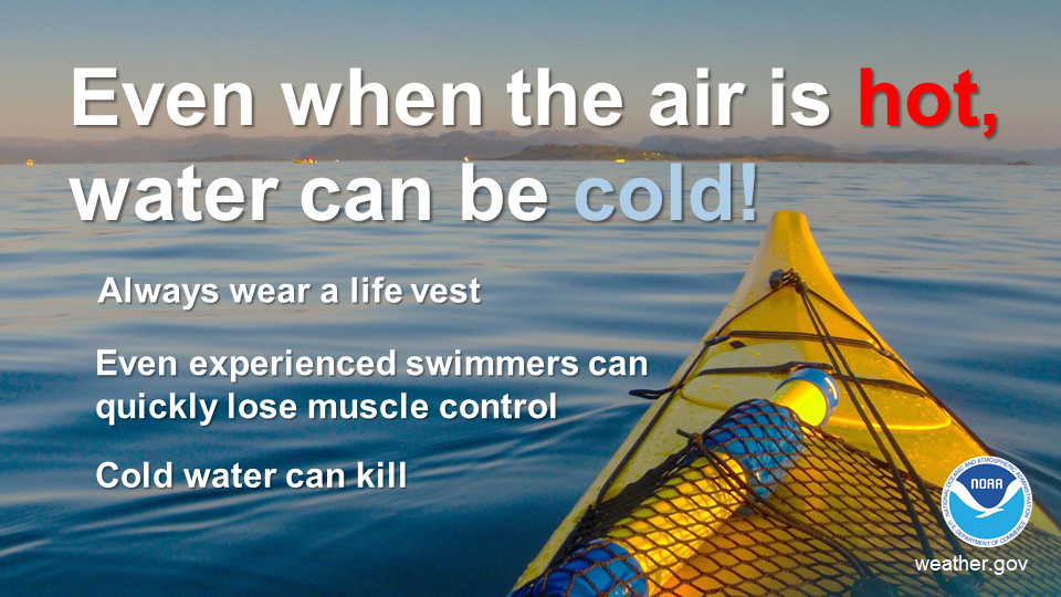
.png) Surf Forecast/Rip Currents
Surf Forecast/Rip Currents Map View
 Marine
 Text Products
.png) Skywarn
Skywarn Submit Storm Reports
 Coastal Flood