Tropical Landfall and Impact Statistics (Through 2014)
Landfall: The intersection of the surface center of a tropical cyclone with a coastline. Because the strongest winds in a tropical cyclone are not located precisely at the center, it is possible for a cyclone's strongest winds to be experienced over land even if landfall does not occur. Similarly, it is possible for a tropical cyclone to make landfall and have its strongest winds remain over the water. Compare direct hit, indirect hit, and strike.
|
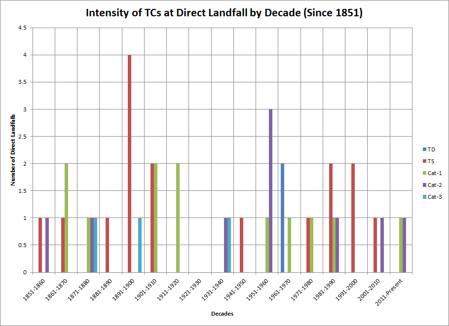
Intensity at Landfall |
|
|
Storm Category |
Number of Occurances |
|
TD |
2 |
|
TS |
16 |
|
Cat 1 |
12 |
|
Cat 2 |
9 |
|
Cat 3 |
3 |
|
Cat 4 |
0 |
|
Cat 5 |
0 |
|
Total Storm #: |
41 |
.png)
|
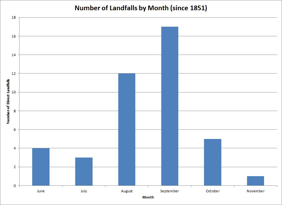
Landfalls by County (Initial County Hit) |
||
|
County |
Number of Landfalls |
Intensity |
|
Carteret |
26 |
1-TD; 12-TS; 8- Cat 1; 4- Cat 2; 1-Cat 3 |
|
Dare |
8 |
3- TS; 1- Cat 1; 3- Cat 2; 1- Cat 3 |
|
Hyde |
2 |
1- Cat 1; 1- Cat 3 |
|
Onslow |
6 |
1- TD; 2- TS; 1- Cat 1; 2- Cat 2 |
|
Total |
42 |
|
DIRECT HIT: A close approach of a tropical cyclone to a particular location. For locations on the left-hand side of a tropical cyclone's track (looking in the direction of motion), a direct hit occurs when the cyclone passes to within a distance equal to the cyclone's radius of maximum wind. For locations on the right-hand side of the track, a direct hit occurs when the cyclone passes to within a distance equal to twice the radius of maximum wind. Compare indirect hit, strike.
|
Direct Hits by County |
||||||
|
County |
Number of Hits |
Cat-1 |
Cat-2 |
Cat-3 |
Intensity |
|
|
Onslow |
13 |
7 |
5 |
1 |
7- Cat 1; 5- Cat 2; 1- Cat 3 |
|
|
Carteret |
23 |
12 |
8 |
2 |
12-Cat-1; 9-Cat 2; 2-Cat 3 |
|
|
Pamlico |
14 |
8 |
5 |
1 |
8-Cat 1; 5-Cat 2; 1-Cat 3 |
|
|
Beaufort |
9 |
4 |
4 |
1 |
4-Cat 1; 2-Cat 2; 1-Cat 3 |
|
|
Hyde |
23 |
12 |
7 |
4 |
12-Cat 1; 7- Cat 2; 4-Cat 3 |
|
|
Dare |
25 |
11 |
10 |
4 |
11-Cat 1; 10- Cat 2; 4-Cat 3 |
|
|
Tyrrell |
13 |
7 |
5 |
1 |
7-Cat 1; 5-Cat 2; 1-Cat 3 |
|
|
Washington |
6 |
3 |
2 |
1 |
3-Cat 1; 2- Cat 1; 1-Cat 3 |
|
INDIRECT HIT: Generally refers to locations that do not experience a direct hit from a tropical cyclone, but do experience hurricane force winds (either sustained or gusts) or tides of at least 4 feet above normal.
|
Indirect Hits by County |
||||||
|
County |
Number of Indirect Hits |
Cat-1 |
Cat-2 |
Cat-3 |
Intensity |
|
|
Onslow |
8 |
2 |
3 |
3 |
2- Cat 1; 3- Cat 2; 3- Cat 3 |
|
|
Carteret |
14 |
5 |
5 |
4 |
5-Cat-1; 5-Cat 2; 4-Cat 3 |
|
|
Pamlico |
8 |
4 |
3 |
1 |
4-Cat 1; 3-Cat 2; 1-Cat 3 |
|
|
Beaufort |
4 |
2 |
1 |
1 |
2-Cat 1; 1-Cat 2; 1-Cat 3 |
|
|
Hyde |
9 |
5 |
2 |
2 |
5-Cat 1; 2- Cat 2; 2-Cat 3 |
|
|
Dare |
9 |
3 |
4 |
2 |
3-Cat 1; 4- Cat 2; 2-Cat 3 |
|
|
Tyrrell |
1 |
0 |
1 |
0 |
1-Cat 2 |
|
|
Washington |
4 |
2 |
2 |
0 |
2-Cat 1; 2- Cat 2 |
|
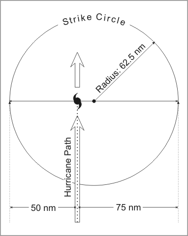
STRIKE: For any particular location, a hurricane strike occurs if that location passes within the hurricane's strike circle, a circle of 125 n mi diameter, centered 12.5 n mi to the right of the hurricane center (looking in the direction of motion). This circle is meant to depict the typical extent of hurricane force winds, which are approximately 75 n mi to the right of the center and 50 n mi to the left.
|
Hurricane Strikes by County |
||||||
|
County |
Number of Strikes |
Cat-1 |
CCat-2 |
Cat-3 |
Intensity |
|
|
Onslow |
22 |
9 |
9 |
4 |
9- Cat 1; 9- Cat 2; 4- Cat 3 |
|
|
Carteret |
37 |
17 |
14 |
6 |
17-Cat-1; 14-Cat 2; 6-Cat 3 |
|
|
Pamlico |
23 |
12 |
9 |
2 |
12-Cat 1; 9-Cat 2; 2-Cat 3 |
|
|
Beaufort |
13 |
6 |
5 |
2 |
6-Cat 1; 5-Cat 2; 2-Cat 3 |
|
|
Hyde |
33 |
17 |
10 |
6 |
17-Cat 1; 10- Cat 2; 6-Cat 3 |
|
|
Dare |
35 |
14 |
15 |
6 |
14-Cat 1; 15- Cat 2; 6-Cat 3 |
|
|
Tyrrell |
14 |
7 |
6 |
1 |
7-Cat 1; 6-Cat 2; 1-Cat 3 |
|
|
Washington |
10 |
5 |
4 |
1 |
5-Cat 1; 4- Cat 1; 1-Cat 3 |
|
|
Major Hurricane Strikes by County |
|
|
County |
Number of Strikes |
|
Onslow |
4 |
|
Carteret |
6 |
|
Pamlico |
2 |
|
Beaufort |
2 |
|
Hyde |
6 |
|
Dare |
6 |
|
Tyrrell |
1 |
|
Washington |
1 |
TROPICAL IMPACT DEFINITION: The following tables show the breakdown of all 167 tropical cyclones identified to have affected the Newport/Morehead City County Warning Area. Each of these tropical cyclones is included because they brought some type of impact to the region. This study’s definition of a tropical cyclone impact is: “A tropical based system of any intensity that brought adverse weather conditions or natural hazards to an area. An impact can be in the form of wind, heavy rainfall, coastal and inland flooding, storm surge, beach erosion, rip currents, or tornadoes. A tropical cyclone can have an impact on a region without making landfall or being close to the coast, as tropical systems are much larger than a point on a map.
.png)
| Intensity of Tropical Cyclone Impacts | Percent of Total Tropical Cyclones |
| Tropical Depression | 7.14% |
| Tropical Storm | 51.19% |
| Category 1 Hurricane | 15.48% |
| Category 2 Hurricane | 10.12% |
| Category 3 Hurricane | 4.17% |
| Post-Tropical Storm/ET | 11.90% |
|
Intensity at MHX CWA Impact |
|
|
Storm Category |
Number of Occurrences |
|
ET |
20 |
|
TD |
12 |
|
TS |
86 |
|
Cat 1 |
26 |
|
Cat 2 |
17 |
|
Cat 3 |
7 |
|
Cat 4 |
0 |
|
Cat 5 |
0 |
|
Total Storm #: |
167 |
|
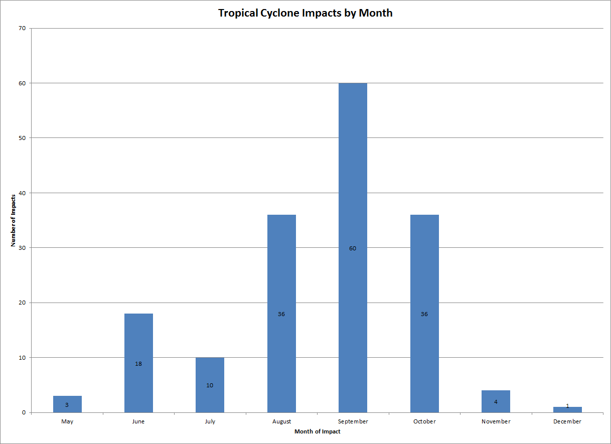
MHX CWA Impacts by Month |
||
|
Month |
Number of Occurrences |
Intensity |
|
May |
3 |
1-TD; 1-TS; 1-Cat 1 |
|
June |
18 |
6-ET; 2-TD; 10-TS |
|
July |
10 |
2-TD; 4-TS; 2-Cat 1; 2-Cat 2 |
|
August |
36 |
1-ET; 3-TD; 14-TS; 9-Cat 1; 6-Cat 2; 3-Cat 3 |
|
September |
60 |
5-ET; 3-TD; 30-TS; 11-Cat 1; 8-Cat 2; 3-Cat 3 |
|
October |
36 |
7-ET; 1-TD; 24-TS; 2-Cat 1; 1-Cat 2; 1-Cat 3 |
|
November |
4 |
3-TS; 1-Cat 1 |
|
December |
1 |
1-ET |
|
Total |
167 |
|


 Map View
 Weather Hazard Briefing (when applicable)
 Forecaster Discussion
 Marine
 Text Products
.png) Skywarn
Skywarn Submit Storm Reports
 Coastal Flood
.png) Surf Forecast/Rip Currents
Surf Forecast/Rip Currents