Major Ice/Snow Event, January 28-29, 2014
Summary
A highly unusual, prolonged winter weather event unfolded over eastern North Carolina beginning during the morning of January 28, 2014 and continued into the mid-morning hours of January 29. This was an especially high-impact event for eastern North Carolina as many schools and businesses were closed for 4 days due to widespread hazardous road conditions. This event was unusual in the large accumulations of ice and sleet that occurred, in addition to significant snow accumulations over inland areas (Figure 1).
The precipitation began as several hours of freezing rain over coastal sections of Carteret and Onslow Counties. A few reports of up to 1/4 inch of ice were reported, especially in Carteret County. The freezing rain changed to sleet during the mid to late afternoon hours near the coast and started to work its way inland. With an initially very dry subcloud layer over inland areas, it took several hours for the airmass to saturate and for precipitation to reach the ground inland. By late afternoon, most areas were reporting a mix of sleet and freezing rain. By around 7 pm Tuesday, the precipitation began to transition to snow over most inland areas (Figure 2) as a surface low started to slowly gain strength and move well off the North Carolina coast. However, a pronounced warm nose aloft (Figure 3) in the 7 pm (00Z) Newport/Morehead City upper air sounding, kept the precipitation as a steady sleet over coastal sections through much of the night before transitioning to snow in the early morning hours of Wednesday, January 29. The precipitation gradually ended by mid to late morning on Wednesday.
With an accretion of freezing rain, 1 to 2 inches of sleet and as much as 7 inches of snow, roads across eastern North Carolina became very hazardous. Numerous accidents were reported and most all schools were closed from Tuesday through Friday. Temperatures below freezing and cloud cover kept much of the snow and ice from melting until Friday.
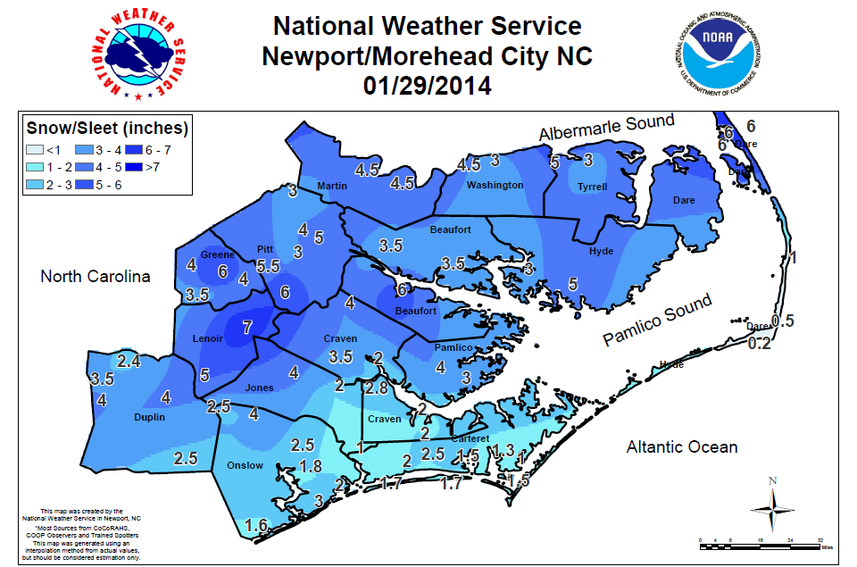
Figure 1. Snow/Ice Accumulations for January 28-29, 2014.
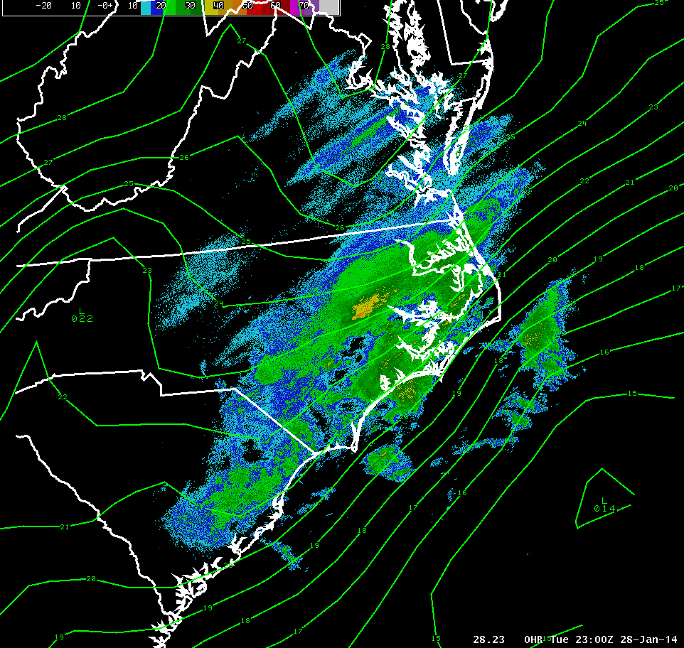
Figure 2. Radar at 6 pm Tuesday January 28. Surface low well offshore with snow falling inland and sleet near the coast.
.png)
Figure 3. The 00Z Sounding from Newport/Morehead City shows a significant warm nose aloft (the red line is the 0 degree Celsius line).
.jpg)
Snow and ice cover roadways in Morehead City.


.png) Surf Forecast/Rip Currents
Surf Forecast/Rip Currents Tropical Weather
 Map View
 Weather Hazard Briefing (when applicable)
 Forecaster Discussion
 Marine
 Text Products
.png) Skywarn
Skywarn Submit Storm Reports