Hurricane Diana September 13, 1984
Event Overview
Hurricane Diana was the fourth tropical storm, the first hurricane, and the strongest storm of the 1984 Atlantic Hurricane Season. Diana was the first major hurricane to hit the Eastern United States in the previous 20 years and the most intense hurricane to strike the coast since Hazel in 1954. Diana caused moderate damage in North Carolina while it made an anticyclonic loop offshore (Figure 1) and after it made landfall as a Category 2 hurricane in the Cape Fear area. Forming on September 8, 1984, Diana moved northward and wandered across North Carolina for a couple of days during mid-September, dropping heavy rainfall. Once it left the state and accelerated east-northeast, Diana (Figure 2) quickly evolved into an extratropical cyclone. Damages to the United States totaled $65.5 million dollars (1984 USD). Three indirect fatalities were caused by the cyclone.
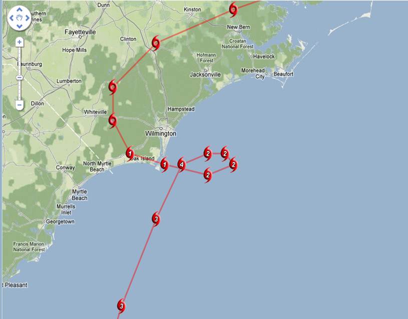
Figure 1. Track of Hurricane Diana, September 11-13, 1984.
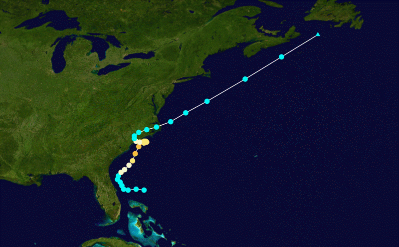
Figure 2. Full track of Hurricane Diana, September 8-16, 1984.
Evolution and Impacts
A deep closed low developed near the tail end of a frontal trough in the Bahamas, and convection increased on the September 7, 1984. Winds increased to tropical storm strength on September 8, and the cyclone was designated Diana. After initially drifting westward and threatening the central Florida coast, the system moved north-northeast ahead of a frontal system moving out of Canada, essentially ovar the Gulf Stream. The cold front bypassed the hurricane to the north, allowing it to move in a slow anticyclonic loop just off of the Cape Fear region of North Carolina. On the morning of the September 13, Diana finally made landfall as a category two hurricane south of Wilmington, NC (Figure 3), and weakened into a tropical storm 12 hours later. The blocking high moved out to sea, allowing the storm to move offshore to the east, near Oregon Inlet on September 14. In a favorable environment, the system nearly regained hurricane strength. After passing just north of Sable Island, Nova Scotia, the cyclone became extratropical as it passed through Newfoundland on September 16, 1984.
The highest observed winds associated with Diana occurred at the Oak Island Coast Guard station south of Wilmington with sustained winds of 115 mph. Winds were much less over the Newport/Morehead City County Warning Area as the storm center passed through Warsaw, Kinston, Belhaven and offshore near Oregon Inlet, however some trees were knocked down in Duplin and Lenoir Counties. There were no confirmed tornadoes from Diana.
The main impacts in Eastern North Carolina were from flooding, as up to 14 inches of rain were reported in Duplin County (Figure 3). A dam failure was reported at Faison in Duplin County. Tides of 4 to 5 feet above normal were observed at Fort Macon with minor to moderate beach erosion along the beaches of Carteret and Onslow Counties.
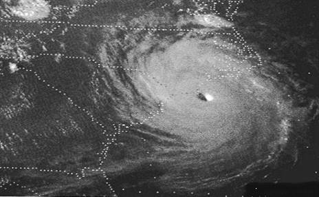
Figure 3. Hurricane Diana at peak intensity east of the Cape Fear Region, September 13, 1984.
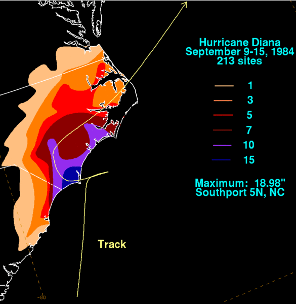
Figure 4. Rainfall amounts from Hurricane Diana, September 9 through 15, 1984.
Sources
National Hurricane Center
Wikipedia
Associated Press
Sciencephoto.com


 Map View
 Weather Hazard Briefing (when applicable)
 Forecaster Discussion
 Marine
 Text Products
.png) Skywarn
Skywarn Submit Storm Reports
 Coastal Flood
.png) Surf Forecast/Rip Currents
Surf Forecast/Rip Currents