Event Overview –
Tropical Storm Gabrielle made landfall on September 9, 2007, just before noon at the Cape Lookout National Seashore. Gabrielle developed as a subtropical cyclone on September 8 about 385 miles southeast of Cape Lookout. Unfavorable wind shear impacted the storm for much of its duration. Based on evidence of a weak warm-core and with weaker wind shear, the system was re-designated as Tropical Storm Gabrielle late on September 8 about 185 miles southeast of Cape Lookout. Gabrielle made landfall with winds of 60 mph. Turning to the northeast, the storm quickly weakened and dissipated on September 11 (Figure 1).
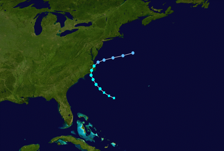
Figure 1. Path of Tropical Storm Gabrielle, September 8 through 11, 2007.
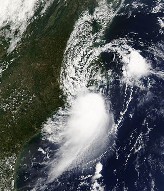
Figure 2. Satellite image of Tropical Storm Gabrielle near the North Carolina coast, September 9, 2007.
Evolution and Impacts –
Gabrielle formed from a decaying cold front just east of the Georgia coast on September 2, 2007. It slowly became better organized as its motion became erratic, and by late on September 4 the convection had become concentrated to the east of the center. Upper-level winds became increasingly favorable, allowing the convection to concentrate about halfway between North Carolina and Bermuda. With a deep-layer ridge to its north, the system turned to a steady west-northwest track. A reconnaissance aircraft flight late on September 7 reported a very elongated center, with peak flight winds of 55 mph about 100 miles northeast of the center. Vertical wind shear decreased as the storm passed over the Gulf Stream, allowing a strong convective burst to develop near the center. As it approached the North Carolina coast, the center re-developed within the deep convection underneath the mid-level circulation, although increased northerly wind shear displaced the center of Gabrielle to the north of the thunderstorm activity. Tracking around the ridge over the western Atlantic, the storm turned to the north and north-northeast (Figure 3), emerging into the ocean near Kill Devil Hills early on September 10 as a poorly organized system with convection far to the south of the center. Gabrielle weakened to a tropical depression shortly thereafter and by midday on September 11, the circulation had become ill-defined and elongated. Gabrielle dissipated well to the south of Nova Scotia. By early the next day, the remnants of Gabrielle were absorbed by an approaching cold front.
The National Hurricane Center issued a Tropical Storm Watch from Edisto Beach, South Carolina to Oregon Inlet, including the Pamlico Sound on September 8. As the storm approached the coast, the watch south of Cape Fear was discontinued, and a Tropical Storm Warning was issued from Surf City to the North Carolina–Virginia border, which was upgraded to a warning on September 9.
Prior to the arrival of the storm, the National Park Service closed visitor centers and campgrounds along the Outer Banks. For about 12 hours, the ferry between Hatteras Inlet and Ocracoke was closed. North Carolina Governor Mike Easley put rescue teams and the National Guard on standby. Sustained Tropical Storm force winds occurred across the coastal waters east of Cape Lookout. Wind gusts between 50 and 60 mph were reported mainly across the southern Outer Banks from Ocracoke to the Cape Hatteras area. Minor beach erosion occurred along the south-facing beaches with an estimated storm surge of 1 to 2 feet along with significant wave action. An estimated sound side surge of 2 to 3 feet occurred across Dare County near Salvo and Rodanthe withoverwash on Highway 12 during the late evening.
Significant rainfall occurred across southern Craven and eastern Carteret counties, where rainfall amounts of 4 to 8 inches were recorded (Figure 4) with a peak amount of over 9 inches at Harlowe. This heavy rainfall resulted in the flooding of several residences and one store in the Morehead City and Beaufort areas.
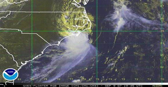
Figure 3. Tropical Storm Gabrielle weakening over Eastern North Carolina, September 9, 2007
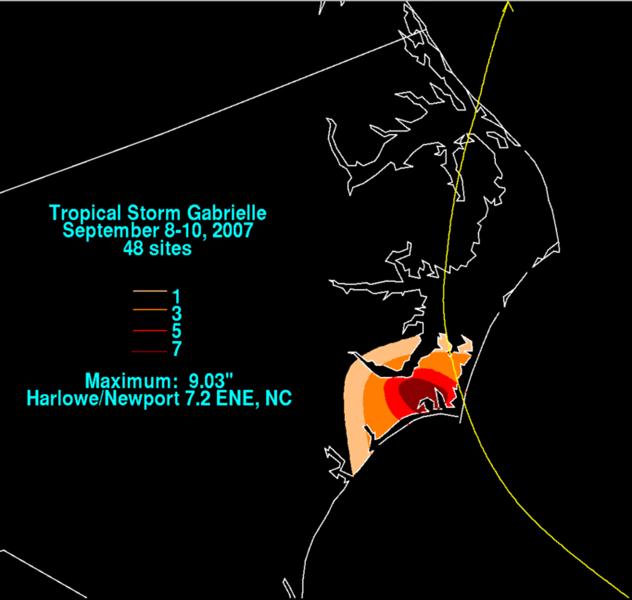
Figure 4. Rainfall Totals from Tropical Storm Gabrielle, September 8-10, 2007.
A. HIGHEST MEASURED WINDS...(ALL SPEEDS ARE UNOFFICIAL)
2-MIN WIND PEAK GUST TIME COMMENTS
LOCATION (ID) (MPH) (MPH) (EDT)
CAPE HATTERAS (HSE) 39 53 741 PM
BEAUFORT (MRH) 33 44 307 PM
NEW BERN (EWN) 18 30 154 PM
CHERRY POINT (NKT) 22 29 354 PM
ONSLOW BEACH (RSLN7) 31 38 800 PM
NEWPORT (MHX) NA 27 227 PM
CEDAR ISLAND (CITN7) 24 35 450 PM
SWANQUARTER (SWQN7) 22 29 950 PM
STUMPY POINT (SPON7) 35 41 220 PM
MANTEO (MQI) 22 33 721 PM
CAPE LOOKOUT (CLKN7) 30 35 500 PM
ONSLOW BAY BUOY (41035) 31 38 550 PM
ONSLOW BAY BUOY (41036) 31 38 220 PM
DUCK COE PIER (DUCN7) 31 35 400 PM
DIAMOND SHOALS (41025) 40 52 600 AM
KITTY HAWK (FFA) 20 31 300 PM
OCRACOKE COOP NA 56 M
OCRACOKE NA 61 M
MOREHEAD CITY STATE PORT NA 47 M
DUCK NA 32 M
KILL DEVIL HILLS NA 32 M
INDIAN BEACH NA 42 400 PM
SURF CITY NA 31 M
COMMENTS KEY
M-TIME UNKNOWN
B. LOWEST PRESSURE...
PRESSURE TIME COMMENTS
LOCATION (ID) (MB) (EDT)
BEAUFORT (MRH) 1008.5 915 AM
CAPE HATTERAS (HSE) 1010.5 410 PM
CHERRY POINT (NKT) 1010.5 254 PM
NEW BERN (EWN) 1010.5 301 PM
CEDAR ISLAND (CITN7) 1008.0 1150 AM
SWANQUARTER (SWQN7) 1007.0 220 PM
STUMPY POINT (SPON7) 1009.0 620 PM
CAPE LOOKOUT BUOY(CLKN7) 1007.3 1000 AM
ONSLOW BAY BUOY (41035) 1011.3 400 PM
ONSLOW BAY BUOY (41036) 1008.6 720 AM
DIAMOND SHOALS (41025) 1010.4 750 AM
DUCK COE BUOY 1010.1 800 PM
COMMENTS KEY
C. RAINFALL...(ALL TOTALS ARE UNOFFICIAL)
STORM TOTAL RAINFALL 9/9/07
LOCATION (ID) AMOUNT(INCHES) COMMENTS
BEAUFORT ASOS (MRH) 7.43
CHERRY POINT ASOS (NKT) 4.52
NEW BERN ASOS (EWN) 1.89
HATTERAS ASOS (HSE) 0.23
NEWPORT NWS 5.36
NEW BERN RAWS 1.12
6N BEAUFORT 8.30
MOREHEAD CITY 7.70
MOREHEAD CITY WASTE WATER PLANT 7.53
HARLOWE (7.2 ENE NEWPORT COCORAHS) 9.03
MOREHEAD CITY (2.9 WNW COCORAHS) 7.07
SMYRNA (COCORAHS) 6.85
NEWPORT (0.2 SW COCORAHS) 5.50
5E AYDEN (COCORAHS) 0.31
AURORA* (AURN7) 0.44
BELHAVEN* (BEEN7) 0.24
GREENVILLE WP* (GREN7) 0.45
JACKSONVILLE* (JEON7) 0.62
OCRACOKE* (OCRN7) 0.34
PERRYTOWN* (PYTN7) 1.33
WILLIAMSTON* (WLLN7) 0.39
BUNYAN 3ESE (BNYN7) 0.32
HOFMANN FOREST (HFMN7) 0.61
GREENVILLE TOWN COMMONS (PGVN7) 0.42
MOREHEAD CITY MESONET 6.93
DAVIS MESONET 4.88
INDIAN BEACH MESONET 2.19
SURF CITY MESONET 0.43

Building surf during Tropical Storm Gabrielle, September 7, 2007
Case Study Team:
Chris Collins


 Map View
 Weather Hazard Briefing (when applicable)
 Forecaster Discussion
 Marine
 Text Products
.png) Skywarn
Skywarn Submit Storm Reports
 Coastal Flood
.png) Surf Forecast/Rip Currents
Surf Forecast/Rip Currents