Event Overview
Several severe thunderstorms developed and moved through Eastern North Carolina during the afternoon and evening hours of October 1, 2008. These storms formed ahead of a surface cold front and lee trough.
Pre-Storm Environment
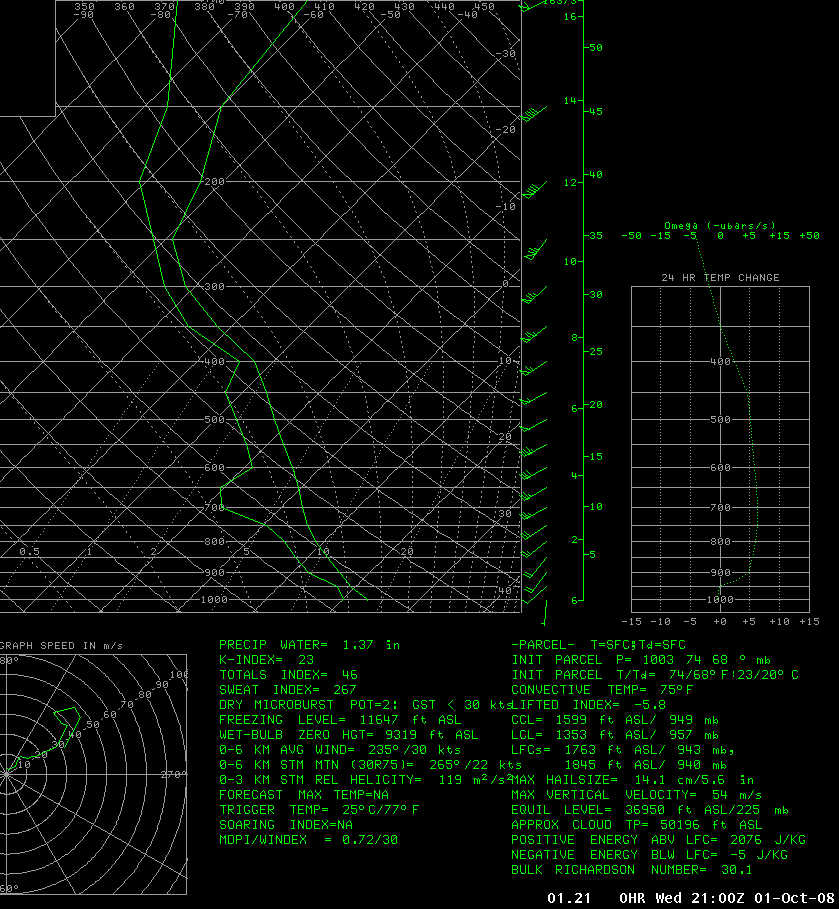
At 17z a there was a closed upper level low over the Great Lakes with associated upper trough deepening over the east coast. A 1006 mb surface low was located near Fayetteville, NC ahead of a surface cold front. It was very moist across eastern North Carolina ahead of the lee trough and front, with dewpoints in the upper 60s. Afternoon mixed level CAPES were around 1500-2000 J/kg. Lapse rates steepened through the day with approaching cooler air at the midlevels coupled with continued daytime surface heating. Freezing levels were around 10.5 kft and wet bulb zero levels 9.5 kft. The surface low strengthened to 1003 mb, and tracked east/northeast and by 22z was located right along the coast, with the cold front bisecting the county warning area west to east. Hail and damaging wind gusts were the primary threats for the day. Though there was the potential for isolated tornados, due to the position and track of the surface low.
The following is a Mesoscale Discussion from the Storm Prediction Center prior to the issuance of a Severe Thunderstorm Watch for the area:
MESOSCALE DISCUSSION 2303
NWS STORM PREDICTION CENTER NORMAN OK
1128 AM CDT WED OCT 01 2008
AREAS AFFECTED...E NC AND SE VA
CONCERNING...SEVERE POTENTIAL...WATCH LIKELY
VALID 011628Z - 011900Z
H5 CHART AND WATER VAPOR IMAGERY DEPICT A HEALTHY JET STREAK
/MID-LVL HEIGHT FALLS 90 METERS AT KILN/ DIGGING INTO THE LWR OH/TN
VLYS AT LATE MORNING ALONG THE BASE OF THE GRTLKS UPR TROUGH. THE
IMPULSE WILL SPREAD ESE INTO VA AND NC BY MID-AFTN.
READJUSTMENTS OF THE MASS FIELDS WERE OCCURRING RAPIDLY AHEAD OF THE
AFOREMENTIONED JET STREAK. OLD FRONT THAT SETTLED SWD INTO NC LAST
NIGHT HAS DISSOLVED WITH REDEVELOPMENT FARTHER W IN THE PIEDMONT.
THE 15Z MESOANALYSIS PLACED A 1006 MB LOW INVOF KFAY WITH A N-S
ORIENTED LEE TROUGH EXTENDING FROM E SC INTO E VA. THE NEW COLD
FRONT WAS BEGINNING TO SURGE SEWD IN THE KRDU METRO AND THE
FOOTHILLS OF WRN NC WITH THE APCH OF THE UPR IMPULSE.
AHEAD OF THE TROUGH...VSBL SATL SHOWS EVIDENCE OF MORE SUBSTANTIAL
BOUNDARY LAYER MOISTURE...MARKED BY DISSOLVING STRATUS
FIELD...SURGING NWD INTO ECNTRL NC ATTM. MID-UPR 60S F SFC DEW
POINTS SHOULD BE MAINTAINED AND/OR TRANSPORTED NWD TOWARD EXTREME SE
VA INTO THIS AFTN. THOUGH MID-LVL LAPSE RATES ARE CURRENTLY LESS
THAN 6 C PER KM...SOME STEEPENING IS EXPECTED THIS AFTN OWING TO THE
APCH OF COOLER MID-LVL TEMPERATURES AND CONTINUED HEATING OF THE
SFC. AFTN MLCAPES OF 1500-2000 J/KG WILL BE LIKELY OVER ERN NC AND
1000-1500 J/KG OVER EXTREME SE VA.
TSTMS WILL BE LIKELY ALONG/AHEAD OF THE LEE-TROUGH/COLD FRONT
THROUGH THE AFTN. FIRST STORMS SHOULD INITIATE BY 18Z ALONG THE
LEADING EDGE OF THE MORE ROBUST MOISTURE RETURN ACROSS EC/NERN NC
AND EXTREME SE VA. OTHER STORMS WILL DEVELOP 18-21Z FARTHER S AHEAD
OF THE SFC LOW/FRONT FROM SE NC NEWD INTO ECNTRL NC/OUTER BANKS.
ROUGHLY 45-50 KTS OF WSW FLOW WILL MAINTAIN AMPLE VERTICAL SHEAR FOR
SUSTAINED SUPERCELLS AND MULTICELL BANDS CAPABLE OF LARGE HAIL AND
DMGG WIND GUSTS. THOUGH WEAK LOW-LVL FLOW WILL PERSIST...THREAT FOR
ISOLD TORNADOES WILL EXIST...PARTICULARLY VCNTY THE SFC LOW TRACK
FROM SCNTRL-ECNTRL NC THROUGH EARLY EVENING.

Synoptic Overview
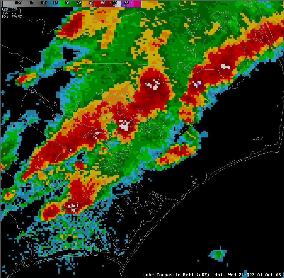
The Storm Prediction Center issued Severe Thunderstorm Watch # 910 at 1730z for all of Eastern North Carolina. The primary threat of the day was hail, although there was an isolated tornado threat as well…with primarily a blend of multicellular, linear storms and few discrete supercells. Storms began to initiate around 18z and move northeastward into the coastal plain ahead of the advancing trough. Storms intensified and moved across most of easternNorth Carolina in the moist unstable air aided by the entrance region of a 250 mb 100+ knot jet. Reflectivity signatures used in warning decision making were generally elevated cores with 55 dbz height around 19kft. There was a really strong cell with good rotation in Sampson and Wayne counties, which a tornado warning was issued for as it moved into Lenoir County, as it began to move to the right. But the storm began to weaken as it began making the right turn into Lenoir County.

The following is a Mesoscale Discussion from the Storm Prediction Center issued during the event:
MESOSCALE DISCUSSION 2305
NWS STORM PREDICTION CENTER NORMAN OK
0324 PM CDT WED OCT 01 2008
AREAS AFFECTED...E NC AND SE VA
CONCERNING...SEVERE THUNDERSTORM WATCH 910...
VALID 012024Z - 012200Z
THE SEVERE WEATHER THREAT FOR SEVERE THUNDERSTORM WATCH 910
CONTINUES.
1003 MB SFC LOW WAS DEVELOPING QUICKLY ENE AND SHOULD MOVE INTO THE
STRONGEST 3-HRLY PRESSURE FALLS INVOF THE NAGS HEAD REGION BY 00Z.
IN WAKE OF THE LOW...A COLD FRONT WAS STRENGTHENING AND WILL SWEEP
SEWD ACROSS SC AND MOST OF MAINLAND NC BY NIGHTFALL AND THE CSTL
LOCATIONS BY 03Z.
BLEND OF DISCRETE SUPERCELL AND MULTICELL LINE MODES WERE WELL
REPRESENTED THIS AFTN WITH A FEW REPORTS OF GOLFBALL AND SLIGHTLY
LARGER SIZED HAIL ASSOCD WITH THE SUPERCELLS. VWP DERIVED
HODOGRAPHS ARE STILL EXHIBITING NEARLY 50 KTS OF 0-6KM SHEAR...BUT
INCREASING NUMBER OF STORMS HAS YIELDED A TREND TOWARD LINEAR STORM
MODES SINCE 19Z. HIGHEST POTENTIAL FOR SVR TSTMS WILL EXIST TO THE
E OF THE APCHG COLD FRONT AND NE OF BOUNDARY LAYER DRYING ASSOCD
WITH THE LEE-TROUGH. NAMELY...AREAS N OF KILM NEWD INTO THE PAMLICO
SOUND REGION INCLUDING CAPE HATTERAS COULD EXPERIENCE LARGE HAIL...
DMGG WIND GUSTS AND PERHAPS A BRIEF TORNADO THROUGH 00Z.
There were a total of 25 warnings issued October 1, 2008: 20 severe thunderstorm warnings and 5 tornado warnings. Reports of penny size to golf ball size hail were reported across Eastern NC. Golfball size hail was reported in Blounts Creek, NC in Beaufort County. Several funnel clouds were reported in Pitt, Martin, and Beaufort counties…with no confirmed tornado touchdowns.