March 28, 2005 Severe Thunderstorms
Event Overview
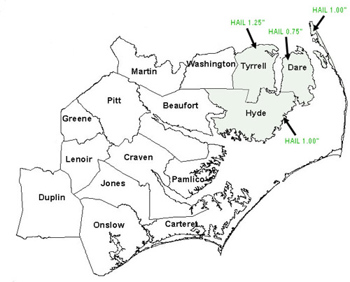
Several severe thunderstorms with hail occurred in eastern North Carolina during the morning and afternoon hours of March 28, 2005. 1.25" (half dollar sized) hail was reported in Tyrrell county, 3/4" hail (penny sized) was reported in mainland Dare county, and 1.00" hail was reported in both mainland Hyde and Outer Banks Dare counties.
Severe Weather Reports - Local storm reports from March 28, 2005 show several large hail reports over eastern North Carolina.
Synoptic Overview
A strong closed 500 mb low was located over eastern Tennessee at 12Z on the morning of March 28, 2005. Ahead of the low, a large area of showers and thunderstorms spread across Eastern North Carolina. A 90 knot southwesterly jet was observed at 500 MB with a 140 knot southwesterly jet at 300 MB. A warm front advanced northward from near the North Carolina/South Carolina border at 09Z to near the Virginia/North Carolina border by 12Z. As a result, a warmer and more unstable airmass moved into central and eastern North Carolina. Some tornado potential existed in the morning given the strong low-level shear in the vicinity of the warm front over eastern North Carolina. Hail was also a threat due the advancing upper low and associated height falls. During the afternoon the shear became more unidrectional and hail became the primary threat as the strong upper-low advanced further across North Carolina.
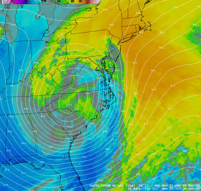
Satellite Imagery - Infrared Satellite Imagery with 500 mb heights overlaid from 415 pm Monday March 28, 2005 showing a deep, closed upper-low centered over western North Carolina. Low freezing/wetbulb-zero heights and steep mid-level lapse rates associated with this upper-low suggested hail would be the primary threat in the afternoon/evening of March 28.
Mesoscale Overview
The strong wind shear in this event was sampled well in the morning MHX VAD wind profile, which showed >90 degrees of veering and more than 30 knots of 0-1 kilometer speed shear. Enhancing situational awareness was the fact that a supercell near Charleston, SC split earlier in the morning with the left-moving member moving northward at around 80 knots through NWS Raleigh's County warning area, producing hail as large as 4 inches in diameter. Around 13Z, a few discrete cells began to form out ahead of the larger area of showers and thunderstorms in eastern North Carolina. The first Special Marine Warning was issued for the Pamlico Sound and the coastal waters from Cape Lookout to Ocracoke at 7:57 am. This cell eventually took on supercell characteristics over the Pamlico Sound and Severe Thunderstorms Warnings were subsequently issued for Mainland portions of Hyde and Dare counties and Outer Banks Dare County. These warnings were verified with several reports of large hail as the storm maintained a 65-70 dbZ core across both counties with VILs maxing out around 55 kg/m3 over the northern Outer Banks. A second cell started to indicate strong low-level rotation over mainland Hyde County near Swanquarter. This strong low-level rotation persisted for several volume scans. A tornado warning was issued for this cell, but because it remained over largely unpopulated areas, no verification was ever received.
Later in the afternoon, as the upper level low moved east across the state, another area of isolated showers and thunderstorms moved into northeast North Carolina. These showers and thunderstorms formed along a dewpoint discontinuity stretching from Onslow county NE through Jones, Craven, Beaufort and Tyrrell counties. Showers forming along the boundary found themselves in more unstable air in Tyrrell county. At around 425 pm, one of these cells briefly pulsed up with a 65 dbZ core and a VIL of 40-45 kg/m3. A Severe Thunderstorm Warning was issued at 428 pm for Tyrrell county. This warning later verified with a report of 1.25 inch hail along the shores of the Albemarle Sound in northern Tyrrell county. A Special Marine Warning was subsequently issued for the Albemarle Sound. Upon reaching Pasquotank county on the opposite side of the sound a Severe Thunderstorm Warning was issued by the NWS Wakefield, VA office. Another Special Marine Warning was issued for the Albemarle Sound at 725 pm after a second thunderstorm intensified over Tyrrell county and produced 40 knot wind gusts at the Alligator River Bridge.
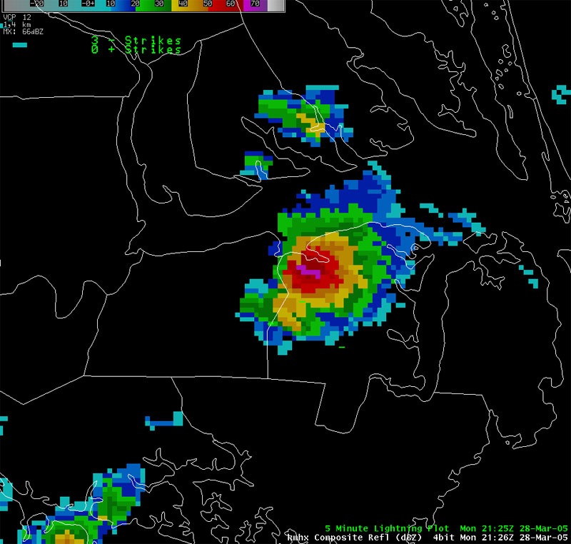
Radar Imagery - 426 pm Composite reflectivity showing 65-70 dBZ core that prompted a Severe Thunderstorm Warning for Tyrrell county. This storm produced 1.25" (half dollar sized) hail.
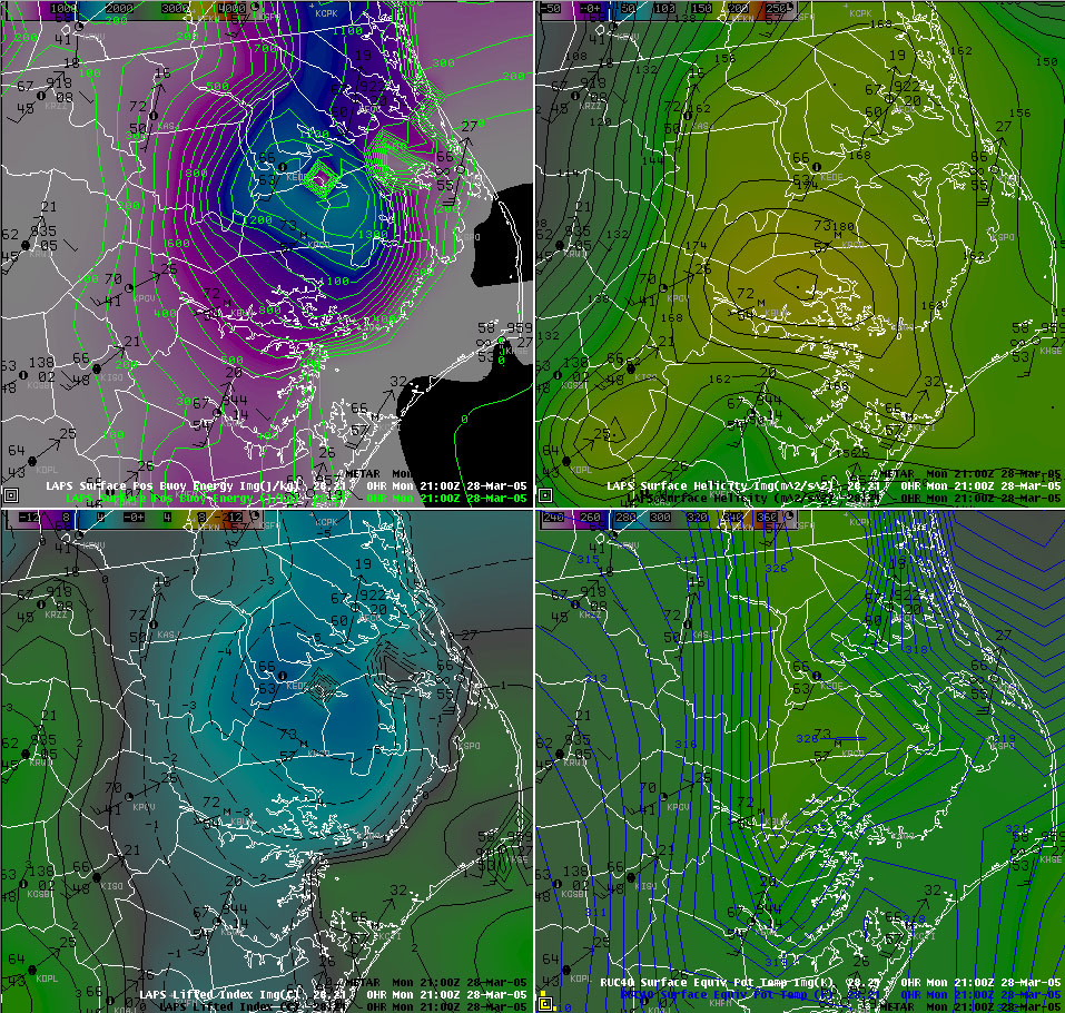
Mesoscale Model/Analysis Imagery - 4-Panel 2100Z (400 pm) display of LAPS CAPE and surface observations (upper left), LAPS helicity (upper right), LAPS lifted index (lower left) and RUC40 surface theta-e (lower right). In the afternoon, showers formed along the theta-e ridge axis in Craven county and advected northeast into more unstable air.
Case Study Team:
Brandon Vincent
Chris Collins


 Map View
 Weather Hazard Briefing (when applicable)
 Forecaster Discussion
 Marine
 Text Products
.png) Skywarn
Skywarn Submit Storm Reports
 Coastal Flood
.png) Surf Forecast/Rip Currents
Surf Forecast/Rip Currents