March 8, 2005 Severe Thunderstorm Outbreak
Event Overview
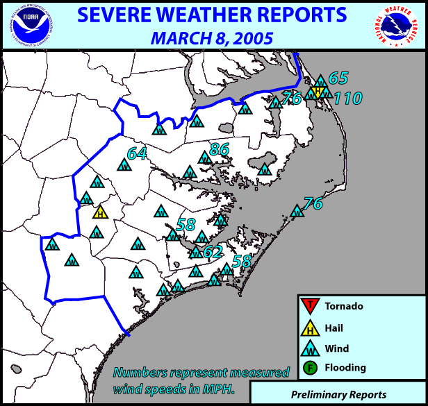
A line of severe thunderstorms marched through North Carolina on the morning hours of March 8, 2005 creating extensive wind damage across the entire state. Eastern North Carolina experienced straight-line wind gusts up to 110 mph, with numerous public reports and ASOS/AWOS measured gusts of 58+ mph. Widespread damage in the Newport/Morehead City CWA consisted of downed trees, road signs, powerlines and extensive structural damage to homes/businesses. Additionally, a communications tower was blown down on the northern Outer Banks. Possible disaster was averted in Beaufort county where the town of Bath was having its 300 year anniversary celebration. Over a hundred people were going to be in an outside tent near lunchtime. Several weather briefings by the Newport/Morehead City NWS office were given earlier in the morning to emergency officials. These briefings, in addition to the timely issuance of severe thunderstorm warnings (30+ minute lead-times) allowed officials more than enough time to evacuate people indoors before the storms arrived. The outdoor tent was subsequently blown down with chairs strewn about as wind gusts up to 86 mph accompanied the severe thunderstorms when they crossed Beaufort county.
ASOS/AWOS Wind Gusts Across the Entire State of NC (MHX CWA METARS in blue):
METAR KILM 081553Z 27033G77KT Wilmington, NC (89 MPH)
SPECI KFBG 081445Z 30040G57KT Fort Bragg, NC (66 MPH)
SPECI KHFF 081421Z 31025G57KT Mackall Airfield, NC (66 MPH)
SPECI KNKT 081640Z 29038G54KT Cherry Point, NC (62 MPH)
SPECI KGSB 081535Z 27043G53KT Seymour-Johnson AFB (61 MPH)
SPECI KECG 081717Z 32041G52KT Elizabeth City, NC (60 MPH)
SPECI KEQY 081303Z 29028G52KT Monroe, NC (60 MPH)
METAR KMRH 081656Z 28037G50KT Beaufort, NC (58 MPH)
SPECI KEWN 081633Z 30026G50KT New Bern, NC (58 MPH)
Public/Spotter Measured Wind Gusts (in blue) in eastern North Carolina:
Kill Devil Hills (Dare County) 110 MPH
Belhaven (Beaufort County) 86 MPH
Alligator River Bridge (Dare/Tyrrell County) 76 MPH
Ocracoke Ferry Office (Hyde County) 76 MPH
Kitty Hawk (Dare County) 65 MPH
Greenville (Pitt County) 64 MPH
Severe Weather Reports - Local storm reports from March 8, 2005 show numerous high wind reports/damage over all of eastern North Carolina.
Synoptic Overview
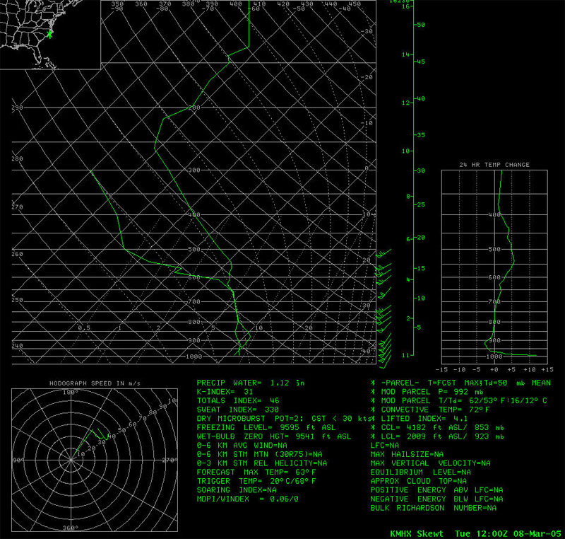
On the morning hours of March 8, 2005 a deep, negatively tilted 500 mb trough was digging into western North Carolina. Further aloft, at 250 mb, a 180+ knot jet max existed over GA and off the GA/SC coast, with eastern NC in the left exit region. Strong divergence values and 50 knot cross-height ageostrophic wind components (towards higher heights) along and off the NC/SC coast showed just how much the atmosphere was advecting itself out of balance. The 12Z March 8, 2005 MHX upper-air sounding showed a 61 knot (70 mph) low level jet at just 1200 ft AGL! Before and throughout the event, little or no instability was present over eastern North Carolina. Instability during the event was quite weak, indeed, with only 500-750 J/kg or less of CAPE (assessed using the LAPS analysis), primarily directly ahead of the squall line. Ahead of the cold front, temperatures were in the upper 50s to low 60s and dewpoints were predominately in the low to mid 50s. Behind the cold front, temperatures were in the mid 30s to low 40s. At 1800Z (100 pm), after the cold front crossed the Albemarle Sound area, Elizabeth City, NC (KECG) reported peak wind gusts to 52 knots with thundersnow and temperatures near freezing while Kitty Hawk and Manteo, just 30 miles away, reported temperatures near 60 with severe thunderstorms!
The fact that such an extensive severe weather event occurred in the presence of such marginal moisture/instability is a testament to the important role that low-level wind shear and upper-level dynamics play in the development and sustainment of severe thunderstorms.
Mesoscale Overview
At around 1200Z (7am) on March 8, 2005 a squall line formed west of Charlotte, NC along a strong surface cold front and downstream of a deep, negatively-tilted upper trough. The squall line proceeded to rapidly propogate across the state. Severe thunderstorm warnings were issued by NWS offices in Greenville/Spartanburg, SC and Raleigh, NC as the line of storms continued to move east. The sustained, impressive radar characteristics of the squall line as it crossed the state and the extensive wind damage history that accompanied it allowed NWS Newport/Morehead City, NC forecasters ample time to prepare for warnings as the squall line approached eastern North Carolina. 0.5 degree radial velocities showed 70+ knot inbound winds embedded within the squall line as it approached and subsequently crossed the area.
Upper-Air Sounding - 12Z (7am) March 8, 2005 Newport/Morehead City, NC upper-air sounding showing 60+ kt (70+ mph) winds just above the surface through 500 mb. Note the dry air above 600 mb. Also note the absence of any CAPE in this sounding.
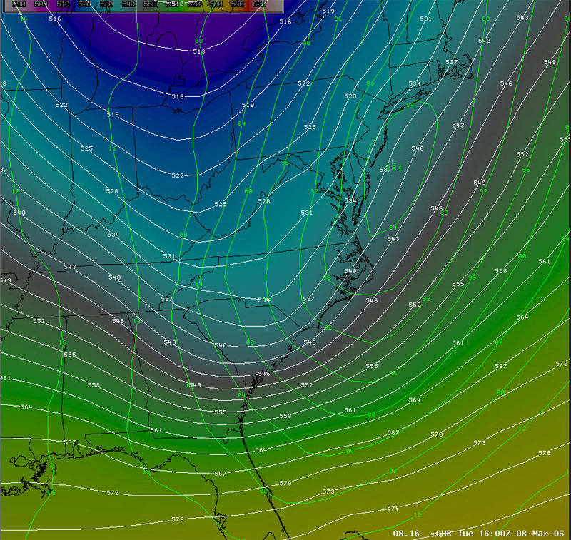
Model Synoptic Analysis - 1600Z (1100am) March 8, 2005 0-HR RUC40 500mb Height and MSLP analysis showing a deep, negatively-tilted 500mb trough digging over North Carolina and a deeping surface low (981 mb) along the coast.
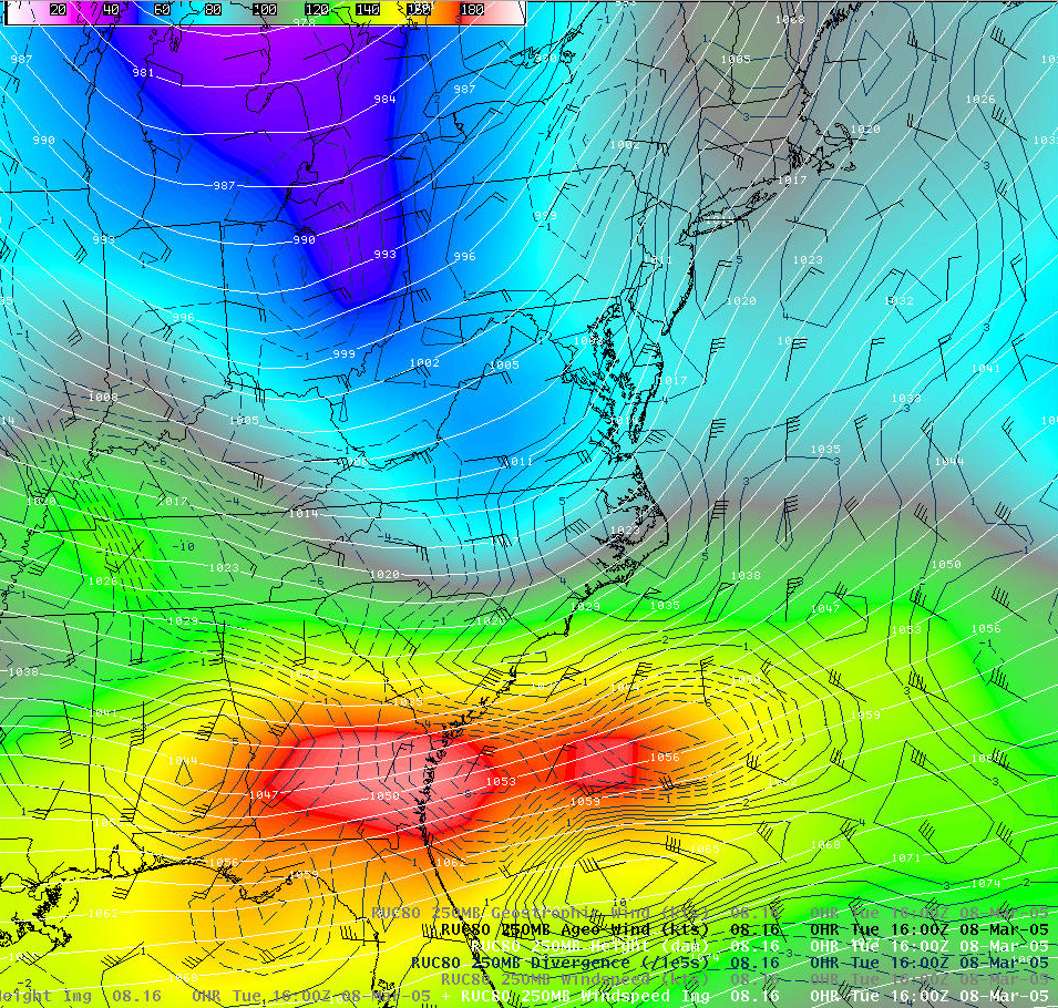
Model Jet Analysis - 1600Z (1100am) March 8, 2005 0-hr RUC40 250mb heights (white), windspeed (image), ageostrophic wind component (barbs) and divergence (solid blue). Note the 180+ knot jet max over GA and off the GA/SC coast with eastern NC in the left exit region. Strong divergence values and up to 60 knot cross-height ageostrophic wind components (towards higher heights) along and off the NC/SC coast show how much the atmosphere was advecting itself out of balance.
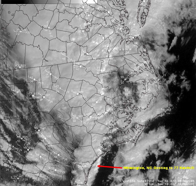
Visible Satellite Imagery - 1600Z (1100am) March 8, 2005 Visible satellite image showing the strong surface front crossing eastern North Carolina. Note the cloud streaks behind and perpendicular to the front, indicating very strong NW winds aloft. Also note Wilmington, NC gusting to 77 knots (89 mph) with the passage of the squall line along the cold front.
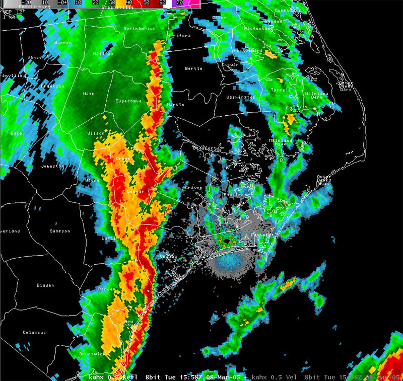
Radar Imagery - 1558Z (1058am) 0.5 degree KMHX reflectivity image showing the squall line crossing eastern North Carolina. Note the bowing of the line in Onslow county, a visual clue that severe winds were occurring.
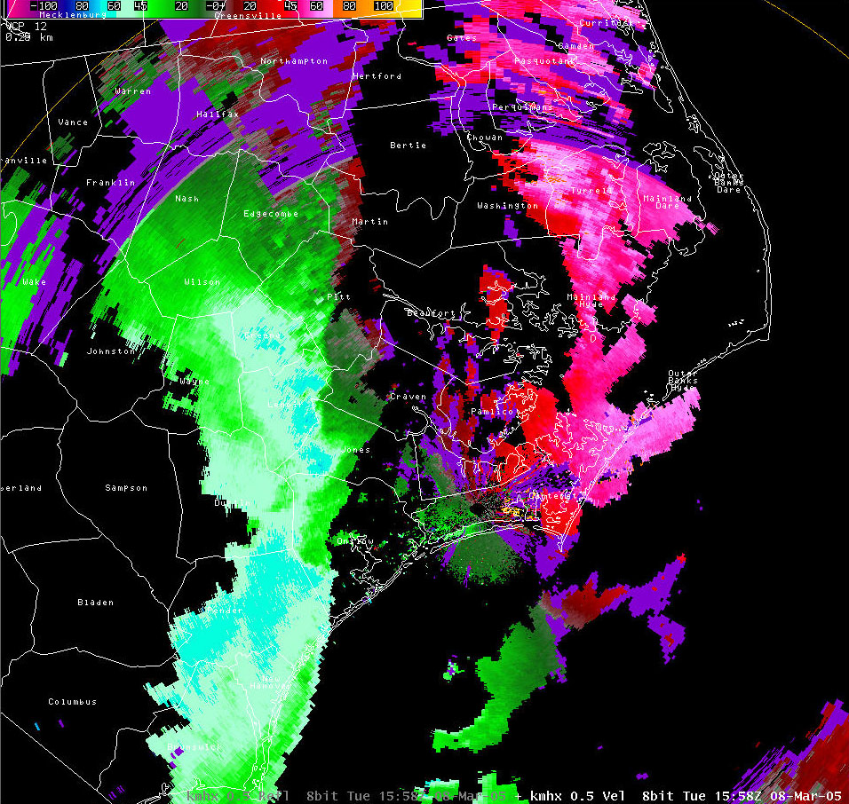
Radar Imagery - 1558Z (1058am) 0.5 degree MHX radial velocity image showing a large area of 64+ knot inbound velocities associated with the squall line. Several pixels of 70+ knot inbound velocities can be found in portions of the squall line.
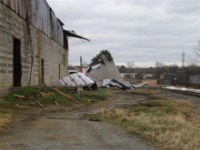
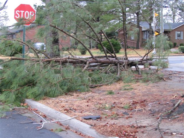
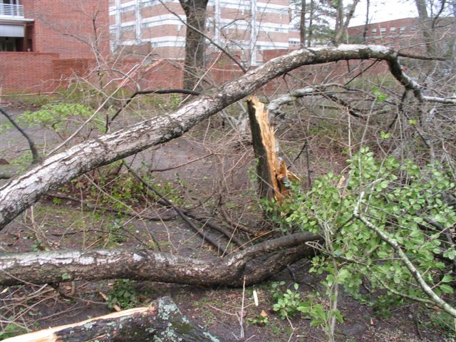
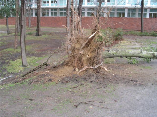
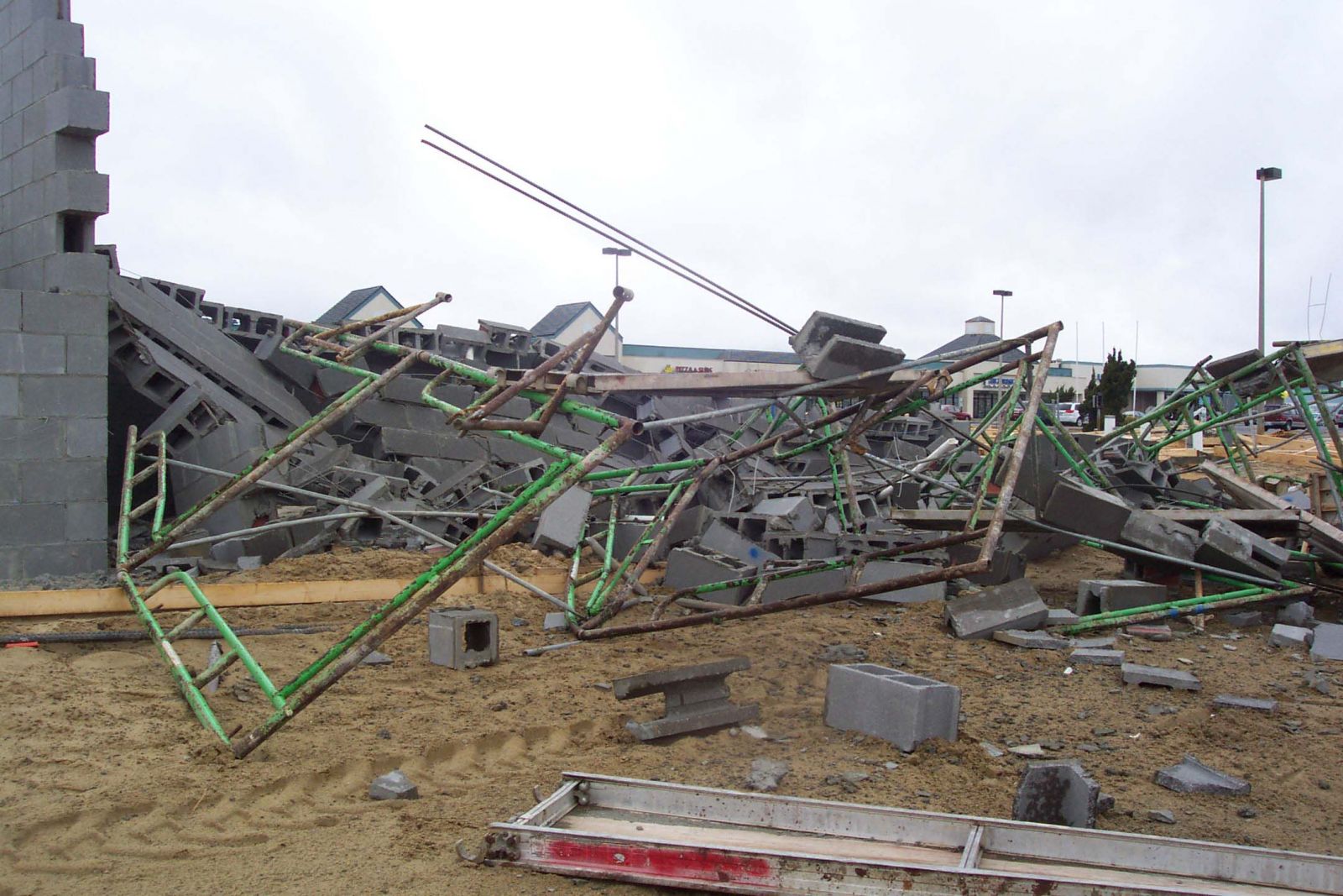
Damage Pictures from Pitt County
Photos courtesy of Eric Christensen, MHX Spotter
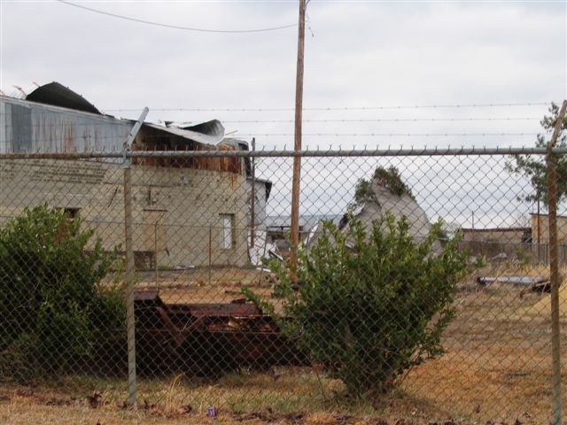
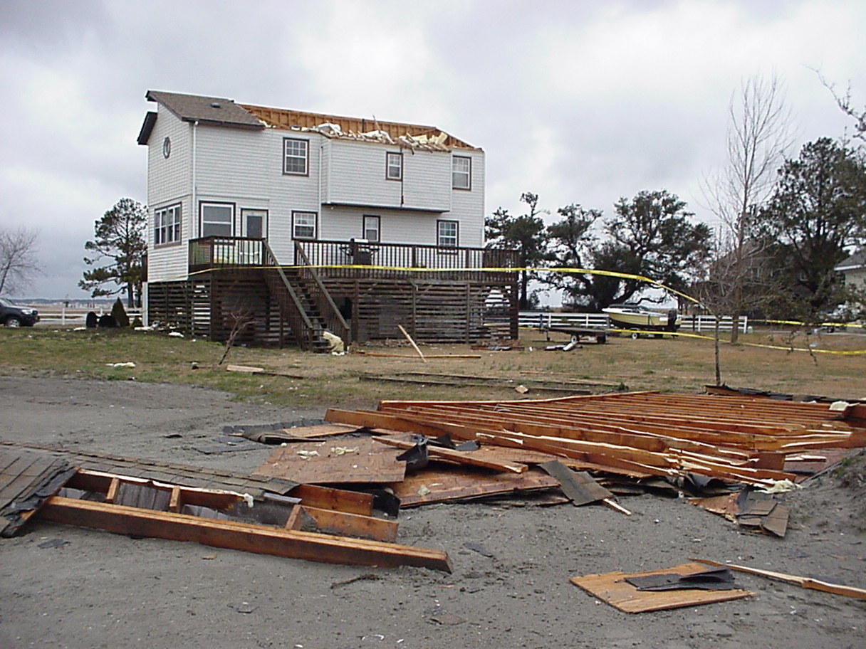
Damage Pictures from Outer Banks Dare County
Photos courtesy of the Outer Banks Sentinel, used with permission.
Case Study Team:
Brandon Vincent
Chris Collins


 Map View
 Weather Hazard Briefing (when applicable)
 Forecaster Discussion
 Marine
 Text Products
.png) Skywarn
Skywarn Submit Storm Reports
 Coastal Flood
.png) Surf Forecast/Rip Currents
Surf Forecast/Rip Currents