Snowstorm of the Century, March, 1, 1980
Event Overview
On the afternoon and evening of March 2, 1980, North Carolina experienced a major winter storm with heavy snow across the entire state and near blizzard conditions in the eastern part of the state. Widespread snowfall totals of 12 to 18 inches were observed over Eastern North Carolina, with localized amounts ranging up to 22 inches at Morehead City and 25 inches at Elizabeth City, with unofficial reports of up to 30 inches at Emerald Isle and Cherry Point (Figure 1). This was one of the great snowstorms in Eastern North Carolina history. What made this storm so remarkable was the combination of snow, high winds, and very cold temperatures.
In addition to the high snow totals, sustained winds of 20 to 40 mph were observed in eastern North Carolina with gusts of over 50 mph. The maximum gust recorded was 62 mph at Cape Hatteras. The winds caused snow drifts up to 8 feet. All travel in North Carolina came to a stop with many stranded motorists in eastern sections. Property damage was estimated at $21.8 million with nearly $10 million in Duplin County to the poultry industry. There were 13 storm related deaths statewide, including 8 in the Newport/Morehead City (MHX) area of responsibility.
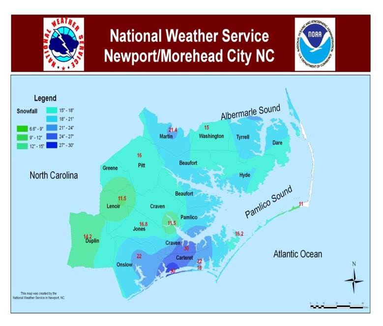
Figure 1. Snowfall Amounts from the March 1-3, 1980 snowstorm.
Synoptic Overview
Arctic air gripped much of the eastern United States in advance of this storm with strong high pressure (1048 mb) over southern Canada and the northern Great Plains providing the cold air (Figure 2). Aloft, a very cold polar vortex moved from the southeastern part of Hudson Bay into the Maritime Provinces of Canada and northern New England as of 00Z March 1 (Figure 3). A potent 500 mb shortwave developed in the strong upper cyclonic flow and dove into the lower Mississippi Valley by 12Z March 2 (Figure 4).
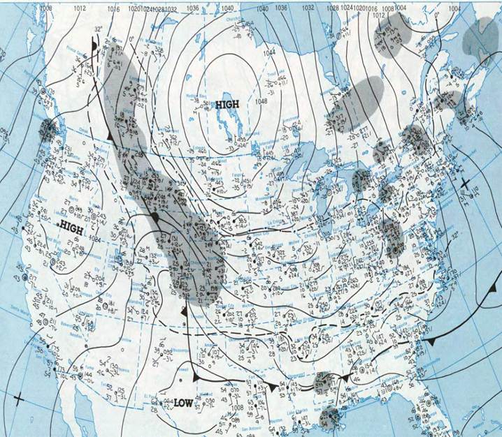
Figure 2. Surface Analysis at 12Z March 1, 1980 showing strong Arctic high pressure covering much of the eastern U.S.
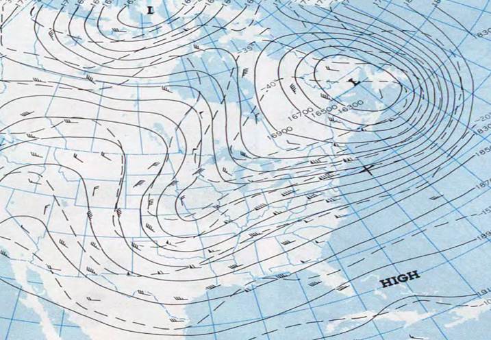
Figure 3. 500 mb Heights at 00Z March 1, 1980 showing cold polar vortex over eastern Canada.
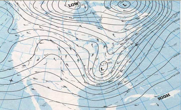
Figure 4. 500 mb Heights/Vorticity at 12Z March 2, 1980 showing shortwave digging across the southern states.
As the shortwave continued to strengthen, the overall system slowed and became neutrally tilted by the afternoon of March 2 with the 500 mb low cutting off over Georgia (Figure 5). By late afternoon on March 2, the system intensifies and becomes negatively tilted with cyclogenesis off the South Carolina coast (Figure 6).
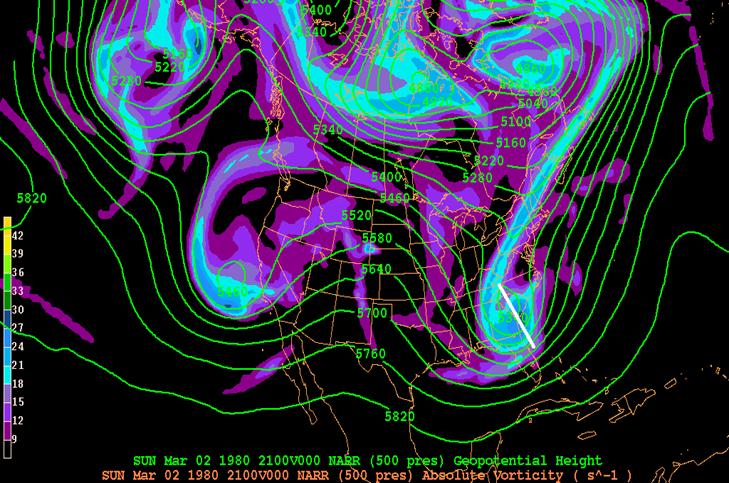
Figure 5. 500 mb Heights/Vorticity at 21Z March 2, 1980 showing upper low becoming negatively tilted and cutting off.
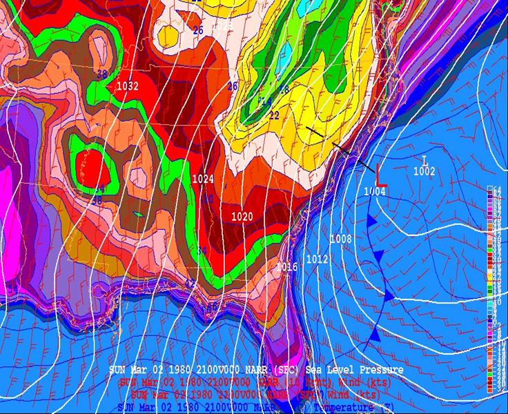
Figure 6. Surface low pressure deepening off the Carolina coast late evening March 2, 1980
During the morning of March 2, snow was falling across Alabama, Georgia, north Florida, eastern Tennessee, South Carolina, North Carolina, and southern Virginia. The precipitation in Eastern North Carolina started as sleet around noon on March 1, creating icy roads. It was during the afternoon and evening on the 2nd, when the very heavy snowfall occurred across eastern North Carolina as the surface low rapidly strengthened offshore to 999 mb by 00Z March 3. At 250 mb, eastern North Carolina was in the area in the right rear entrance region of a jet streak across the northeast, and also in the left front exit region of the jet streak across Florida (Figure 7). This maximized lift over the region with a large area of strong 250 mb divergence (Figure 8). This strong upper divergence corresponded well with the heaviest snowfall amounts. As the surface low continued to move away from the area late on March 2 into early March 3, it “bombed”, creating sufficient instability to produce rare “thunder snow” over the Outer Banks. Gusty winds also accompanied the storm with blizzard like conditions observed. Wind gusts in excess of 60 mph caused not only snow drifts up to 8 feet, but also very cold wind chills.
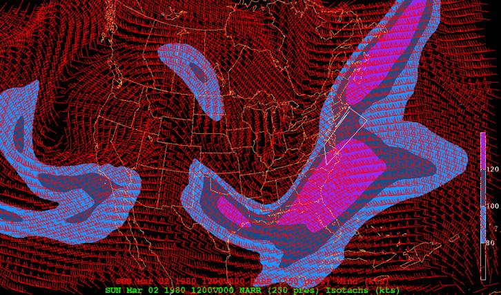
Figure 7. 250 mb Winds showing Eastern North Carolina between 2 jet streaks.
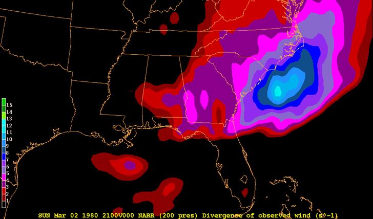
Figure 8. 250 mb Divergence at 21Z March 2, 1980. Divergence matched up well with areas of heaviest snowfall.
The snow continued until early Monday morning March 3 before ending. With the deep snow pack, very cold temperatures were observed in the wake of the storm on Monday March 3, as Cedar Island dropped to 10 degrees and Morehead City to 12 degrees.
Eastern Carolina University Account of the Storm
This account of the March 1980 snowstorm is courtesy of the Joyner Library Archives at East Carolina University in Greenville, NC.
How It Was . . . Remember the Blizzard of March 2, 1980, at ECU.
The bulletin board in the lobby of Mendenhall Student Center read: "Today on Campus . . . Snow . . . No Classes." Classes at ECU were cancelled on Monday and Tuesday, March 3 and 4, and the University slowly struggled back to normal on following days while as much as 20 inches of snow and frozen stuff melted.
The "blizzard" which struck the area on March 2 forced a total closing of ECU the next day. "I can't remember the University closing down before," said Vice Chancellor-Business Affairs C.G. Moore. "We had a big ice storm back in the 60s, but I don't think we closed down even then." Mrs. Agnes Barrett, long-time administrative assistant, recalled that classes were cancelled because of damage from Hurricane Hazel in October 1954. That was wind and water damage.
The blizzard of March 2 paralyzed Eastern North Carolina with as much as 20 to 25 inches of snow, sleet and freezing rain and high winds that whipped up three- to four-foot drifts. "We couldn't have done anything without four-wheel drive vehicles," said Joe Calder, ECU Director of Security. "All of our regular vehicles were snowed in. We borrowed a couple of the Geology Department trucks," Calder said. Others pitched in. A freshman student, Allen Tingle, volunteered his Jeep for emergency trips, such as taking sick students to the infirmary. They ran out of bread and milk and other staples at the campus cafeteria and snack bar and at nearby convenience stores. Pitt Memorial Hospital ran short of blood and there was an appeal for donors. The Post Office suspended service. Newspapers were late.
Snowbound insofar as vehicular traffic was concerned, some students, faculty, and staff found plenty to do -- shoveling snow, for example. Some students with shovels walked from house to house in residential neighborhoods offering to shovel walks and drives. Some students stationed themselves near the icy drifts at street intersections to help the occasional motorists make it through. Many ECU people, however, were virtually marooned. Cars and trucks were stranded all over the area. It was estimated that 3,000 ECU students were more or less stranded in the campus area. They frolicked on the snow-covered hills and streets. Jim Westmoreland, men's residence counselor at Scott Dorm, reported few problems. The cafeteria was serving hamburgers on muffins or French bread. A hot dog on a weiner bun was not to be found. "We had no deliveries of bread or milk for a few days," said Ira Simon, spokesman for Servomation. Shelves of nearby convenience stores were wiped clean of bread, milk, cakes, cookies, and the like.
On Tuesday, University officials waited until a forecast of rising termperatures to decide to resume classes on Wednesday. A great deal of snow remained -- even more melting slush. Slowly, however, things returned to normal. One instructor reported four of his fourteen students made it to class on Wednesday. "It could have been worse," said another professor wryly. "It could have come during spring break."
Most ECU people took it all in stride, although astonished. Student Bonnie Hall of Rich Square was taking pictures of the snow-covered landscape. "I'm going to send pictures to my aunt who went to school here," she said. "She'll never believe that there is this much snow in Greenville."
Acknowledgements
Graphics courtesy of the NOAA NWS NCEP Reanalysis Data Display, NOAA’s Daily Weather Maps, and Allan Huffman at raleighwx.americanwx.com. Other images courtesy of James Merrell and WRAL-TV, Raleigh, NC.
Photos

Photo Courtesy: WRAL TV

Photo Courtesy: Jim Merrell
Case Study Team:
Chris Collins