Event Overview
An area of low pressure was riding northeast along a slow moving frontal boundary near the Virginia/North Carolina border on the afternoon and evening of the 23rd. A mid level disturbance moved across the area during the evening hours to further enhance instability across Eastern North Carolina. There was strong surface heating and a moisture was plentiful ahead of the front, adding to the instability. Thunderstorms already developing along and ahead of the front would be moving into a favorable environment for them to become strong to severe. Eastern North Carolina was placed under a severe thunderstorm watch from around 430 PM until 900 PM EDT. The Newport/Morehead City NWS office issued 4 tornado warnings and 4 severe thunderstorm warnings during the event.
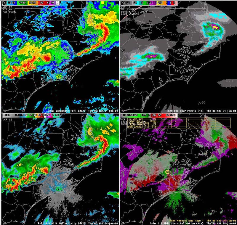
| Radar Imagery | |
|
|
|
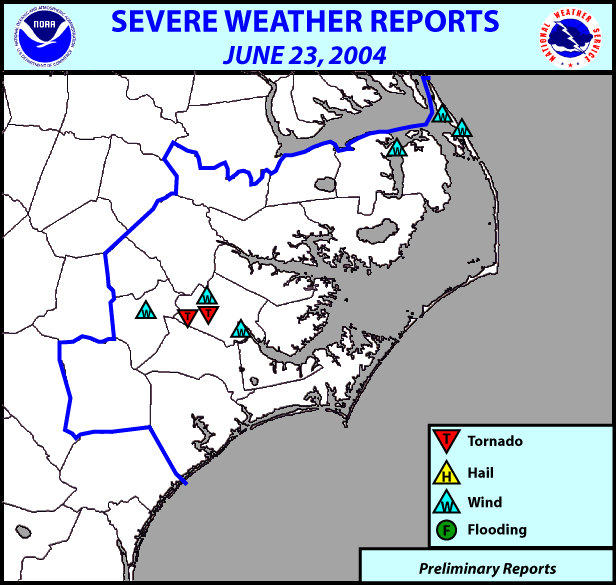
Preliminary Local Storm Reports:
..TIME...   ...EVENT...     ...CITY LOCATION...      ...LAT.LON...
..DATE...   ....MAG....     ..COUNTY LOCATION...ST.. ...SOURCE....
            ..REMARKS..

0741 PM     TSTM WND GST     5 W EAST LAKE           35.87N 76.05W
06/23/2004  58 MPH           TYRRELL            NC   PARK/FOREST SRVC

0812 PM     TSTM WND DMG     KINSTON                 35.28N 77.59W
06/23/2004                   LENOIR             NC   EMERGENCY MNGR

            POWER LINES DOWN WITHIN THE KINSTON CITY LIMITS.

0835 PM     TSTM WND DMG     NAGS HEAD               35.94N 75.63W
06/23/2004                   OUTER BANKS DARE   NC   EMERGENCY MNGR

            MULTIPLE REPORTS OF TREES AND POWER LINES DOWN IN NAGS
            HEAD AREA.

0835 PM     TORNADO          DOVER                   35.22N 77.43W
06/23/2004                   CRAVEN             NC   EMERGENCY MNGR

            TORNADO SPOTTED ON HWY 70 NEAR THE CITY OF DOVER.

0835 PM     TORNADO          2 NE DOVER              35.24N 77.41W
06/23/2004                   CRAVEN             NC   EMERGENCY MNGR

            TORNADO SPOTTED ON WINTERGREEN RD JUST NORTHEAST OF THE
            CITY OF DOVER.

0840 PM     TSTM WND DMG     SOUTHERN SHORES         36.12N 75.73W
06/23/2004                   OUTER BANKS DARE   NC   EMERGENCY MNGR

            TREE DOWN IN SOUTHERN SHORES AT 840 PM.

0845 PM     TSTM WND DMG     FORT BARNWELL           35.27N 77.33W
06/23/2004                   CRAVEN             NC   EMERGENCY MNGR

            MULTIPLE TREES DOWN IN FORT BARNWELL AREA AT 845 PM.


0917 PM     TSTM WND DMG     NEW BERN                35.12N 77.08W
06/23/2004                   CRAVEN             NC   EMERGENCY MNGR

            POWER LINES DOWN ON BROAD ST. IN NEW BERN AT 917 PM.


 Map View
 Weather Hazard Briefing (when applicable)
 Forecaster Discussion
 Marine
 Text Products
.png) Skywarn
Skywarn Submit Storm Reports
 Coastal Flood
.png) Surf Forecast/Rip Currents
Surf Forecast/Rip Currents