|
Synoptic Overview –
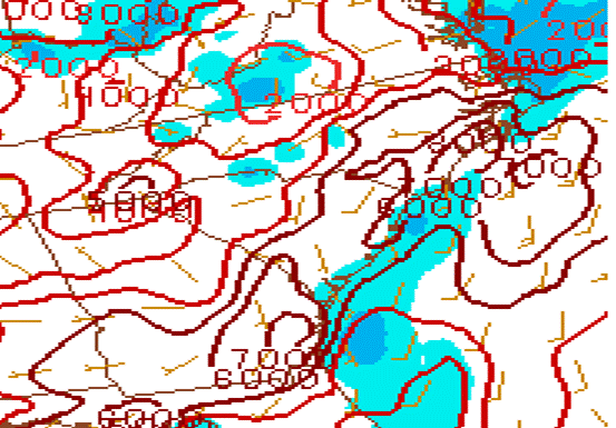
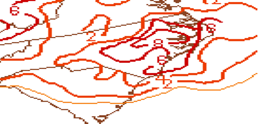
The environment over eastern North Carolina on the afternoon of July 1, 2012 was extremely unstable as an unusually strong heat wave had been underway for several days in advance of the event with widespread temperatures at or above 100 degrees over inland eastern North Carolina. Lifted index values were well below -10 (Figure 3) with Precipitable Water values near 2 inches (Figure 4).
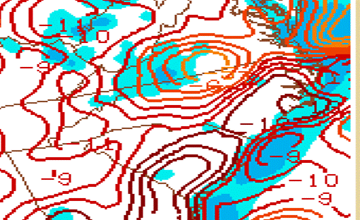
Figure 3. Lifted Index values below -10 over eastern North Carolina at 3 pm July 1, 2012
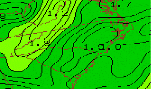
Figure 4. Precipitable Water Values of nearly 2 inches, 3 pm, July 1, 2012.
A weak heat-induced surface trough (Figure 5) was located along the North Carolina piedmont in advance of the developing line of thunderstorms (Figure 6) at mid-afternoon July 1. As the line progressed east into the very unstable airmass, the line of thunderstorms strengthened and began to produce widespread wind damage (Figures 7,8,9).
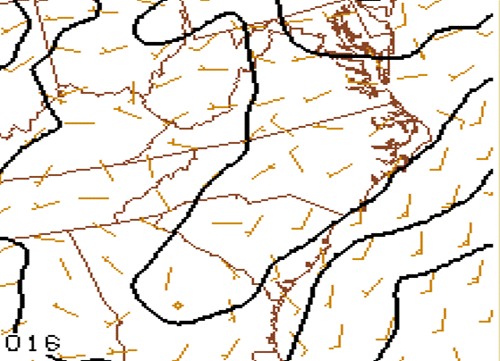
Figure 5. SPC Surface Analysis showing weak heat-induced trough over the North Carolina Piedmont
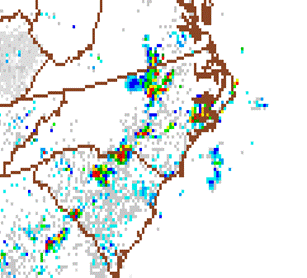 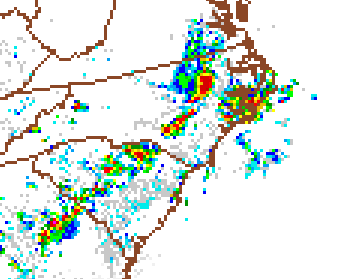
Figure 6. SPC Radar Image at 3 pm July 1, 2012 Figure 7. SPC Radar Image at 4 pm July 1, 2012
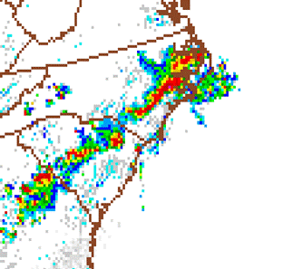 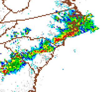
Figure 8. SPC Radar Image at 5 pm July 1, 2012 Figure 9. SPC Radar Image at 6 pm July 1, 2012
This line of severe thunderstorms caused 1 death in Pitt County and 2 deaths in Beaufort County. The Warren Field Airport just outside Washington received extensive damage. Trees were downed and power outages were widespread throughout eastern North Carolina.
PRELIMINARY LOCAL STORM REPORT...SUMMARY
NATIONAL WEATHER SERVICE NEWPORT/MOREHEAD CITY NC
829 PM EDT SUN JUL 01 2012
..TIME... ...EVENT... ...CITY LOCATION... ...LAT.LON...
..DATE... ....MAG.... ..COUNTY LOCATION..ST.. ...SOURCE....
..REMARKS..
0910 AM HAIL 5 SE ROPER 35.83N 76.55W
07/01/2012 E0.75 INCH WASHINGTON NC BROADCAST MEDIA
0315 PM HAIL 1 SE THURMAN 35.03N 76.99W
07/01/2012 M1.00 INCH CRAVEN NC 911 CALL CENTER
RELAYED BY 911 CALL CENTER FROM CRAVEN COUNTY SHERIFFS
DEPUTY
0315 PM HAIL 2 S JAMES CITY 35.04N 77.02W
07/01/2012 E0.50 INCH CRAVEN NC COCORAHS
0320 PM HAIL 2 SE JAMES CITY 35.05N 76.99W
07/01/2012 E1.00 INCH CRAVEN NC PUBLIC
0345 PM MARINE TSTM WIND 2 NW PAMLICO SHORES 35.14N 76.01W
07/01/2012 M47 MPH AMZ135 NC WEATHER FLOW
MEASURED BY WEATHERFLOW STATION AT OCRACOKE
0359 PM HAIL CEDAR ISLAND 35.00N 76.33W
07/01/2012 E1.00 INCH CARTERET NC PUBLIC
REPORTED BY CEDAR ISLAND FERRY TERMINAL
0405 PM TSTM WND GST FARMVILLE 35.59N 77.59W
07/01/2012 E65 MPH PITT NC SPOTTER
SPOTTER ESTIMATED 60-65 MPH WINDS
0420 PM TSTM WND DMG WINTERVILLE 35.53N 77.40W
07/01/2012 PITT NC AMATEUR RADIO
SEVERAL TREES DOWN
0423 PM TSTM WND GST GREENVILLE 35.60N 77.37W
07/01/2012 M74 MPH PITT NC SPOTTER
TRAINED SPOTTER REPORTED 74 MPH WIND GUST ON HOME
WEATHER STATION
0423 PM TSTM WND DMG GREENVILLE 35.60N 77.37W
07/01/2012 PITT NC PUBLIC
10 X 20 BARN DESTROYED
0423 PM HAIL 3 E CALYPSO 35.15N 78.05W
07/01/2012 E1.00 INCH DUPLIN NC PUBLIC
0425 PM TSTM WND DMG GREENVILLE 35.60N 77.37W
07/01/2012 PITT NC PUBLIC
NUMEROUS TREES DOWN IN AN APARTMENT COMPLEX OFF 10TH
STREET
0430 PM TSTM WND GST GREENVILLE 35.60N 77.37W
07/01/2012 M75 MPH PITT NC LAW ENFORCEMENT
MEASURED BY HIGHWAY PATROL ANEMOMETER
0430 PM TSTM WND DMG SIMPSON 35.58N 77.28W
07/01/2012 PITT NC PUBLIC
SEVERAL TREES DOWN THROUGHOUT SIMPSON
0430 PM TSTM WND GST GREENVILLE 35.60N 77.37W
07/01/2012 E65 MPH PITT NC SPOTTER
WIND SPEED ESTIMATED. LARGE TREE DOWN ON 5TH ST IN
FRONT OF ECU ART BUILDING
0433 PM HAIL FORT BARNWELL 35.27N 77.33W
07/01/2012 E1.00 INCH CRAVEN NC PUBLIC
0433 PM TSTM WND DMG 2 S WILLIAMSTON 35.82N 77.06W
07/01/2012 MARTIN NC PUBLIC
ROOF OFF BARN AND NUMEROUS TREES DOWN
0433 PM TSTM WND DMG 1 NW CALICO 35.43N 77.26W
07/01/2012 PITT NC EMERGENCY MNGR
*** 1 FATAL *** SHED FELL ON A MAN WHILE HE WAS TRYING
TO PUT HIS GOLF CART IN STORAGE
0435 PM HAIL KINSTON 35.28N 77.59W
07/01/2012 E1.00 INCH LENOIR NC PUBLIC
0437 PM TSTM WND DMG WASHINGTON 35.56N 77.05W
07/01/2012 BEAUFORT NC PUBLIC
NUMEROUS TREES DOWN
0440 PM TSTM WND DMG WARSAW 35.00N 78.09W
07/01/2012 DUPLIN NC 911 CALL CENTER
911 CALL CENTER REPORTS NUMEROUS POWER LINES DOWN
0440 PM TSTM WND DMG GILEAD 35.45N 76.99W
07/01/2012 BEAUFORT NC EMERGENCY MNGR
*** 2 FATAL *** TREE FELL ON A COUPLE IN A GOLF CART
0445 PM TSTM WND DMG WASHINGTON 35.56N 77.05W
07/01/2012 BEAUFORT NC EMERGENCY MNGR
*** 40 INJ *** OVER 40 TREATED THROUGHOUT THE COUNTY
FOR STORM RELATED INJURIES
0453 PM TSTM WND DMG 3 NW WENONA 35.76N 76.67W
07/01/2012 WASHINGTON NC 911 CALL CENTER
TREES DOWN NEAR HIGHWAY 99 NORTHWEST OF WENONA.
0507 PM TSTM WND GST NEW BERN 35.12N 77.08W
07/01/2012 M65 MPH CRAVEN NC ASOS
0510 PM MARINE TSTM WIND 2 W EAST LAKE LANDING 35.90N 76.01W
07/01/2012 M54 MPH AMZ130 NC PUBLIC
REPORTED BY ALLIGATOR RIVER BRIDGE TENDER
0515 PM TSTM WND DMG 2 NW KILKENNY 35.67N 76.26W
07/01/2012 TYRRELL NC 911 CALL CENTER
TRRES DOWN ALONG HIGHWAY 94 NORTHWEST OF KILKENNY.
0515 PM TSTM WND DMG NEW BERN 35.12N 77.08W
07/01/2012 CRAVEN NC PUBLIC
SEVERAL TREES DOWN IN THE AREA
0518 PM TSTM WND GST CHERRY POINT 34.92N 76.88W
07/01/2012 M84 MPH CRAVEN NC ASOS
0530 PM TSTM WND GST NEW RIVER 34.76N 77.41W
07/01/2012 M62 MPH ONSLOW NC ASOS
0530 PM TSTM WND DMG 5 NW HAVELOCK 34.94N 76.99W
07/01/2012 CRAVEN NC PUBLIC
NUMEROUS TREES DOWN ALONG HWY 70 IN BETWEEN HAVELOCK
AND NEW BERN
0545 PM MARINE TSTM WIND 1 W WAVES LANDING 35.57N 75.49W
07/01/2012 M68 MPH AMZ135 NC WEATHER FLOW
0545 PM TSTM WND GST OCRACOKE 35.10N 75.98W
07/01/2012 M67 MPH HYDE NC WEATHER FLOW
MEASURED BY WEATHERFLOW STATION AT OCRACOKE
0547 PM TSTM WND DMG EMERALD ISLE 34.67N 77.03W
07/01/2012 CARTERET NC PUBLIC
SEVERAL TREES DOWN ALONG EMERALD ISLE
0547 PM TSTM WND DMG CEDAR POINT 34.68N 77.08W
07/01/2012 CARTERET NC SPOTTER
SPOTTER REPORTED A LARGE 20 X 20 TENT BLOWN OVER IN
FRONT OF LOCAL FURNITURE STORE
0550 PM TSTM WND DMG NEWPORT 34.79N 76.86W
07/01/2012 CARTERET NC NWS EMPLOYEE
TREES DOWN JUST WEST OF NWS OFFICE
0555 PM MARINE TSTM WIND FRISCO 35.23N 75.61W
07/01/2012 M56 MPH DARE NC WEATHER FLOW
WEATHERFLOW STATION AT FRISCO WOODS
0556 PM TSTM WND GST BEAUFORT 34.72N 76.65W
07/01/2012 M61 MPH CARTERET NC PUBLIC
MEASURED ON HOME WEATHER STATION
0600 PM TSTM WND DMG NEWPORT 34.79N 76.86W
07/01/2012 CARTERET NC AMATEUR RADIO
TREES DOWN ON POWERLINES NEAR NEWPORT FIRE STATION 43.
REPORTED BY SKYWARN
&&
$$
Damage Pictures from Beaufort and Pitt Counties
Photos courtesy of: NWS Newport/Morehead City Damage Assessment Team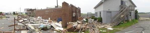
Damage at Warren Field Airport in Washington, NC following July 1, 2012 Derecho
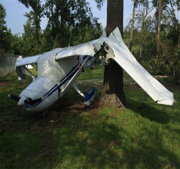
Airplane flipped over near Washington, NC Airport
Case Study Team:
Bob Frederick
Chris Collins
|


 Map View
 Weather Hazard Briefing (when applicable)
 Forecaster Discussion
 Marine
 Text Products
.png) Skywarn
Skywarn Submit Storm Reports
 Coastal Flood
.png) Surf Forecast/Rip Currents
Surf Forecast/Rip Currents